Difference between revisions of "Kashmir Region" - New World Encyclopedia
Mike Butler (talk | contribs) |
Mike Butler (talk | contribs) (Kashmir - economy) |
||
| Line 96: | Line 96: | ||
===Partition=== | ===Partition=== | ||
| − | Ranbir Singh's grandson [[Hari Singh]], who had ascended the throne of Kashmir in 1925, was the reigning monarch in 1947 at the | + | Ranbir Singh's grandson Sir [[Hari Singh]], a Hindu who had ascended the throne of Kashmir in 1925, was the reigning monarch in 1947 at the partition of the British Indian Empire into the newly independent [[Union of India]] and the [[Dominion of Pakistan]]. Both countries had agreed that the rulers of princely states would be given the right to opt for either Pakistan or India or remain independent. |
| − | + | A section of the Muslim population of Kashmir demanded accession to Pakistan. The reigning maharaja, Sir Hari Singh, resisted, Pakistan launched a guerrilla onslaught, and the maharaja signed the Instrument of Accession to the Indian Union. Indian soldiers entered Kashmir and drove the Pakistani-sponsored irregulars from all but a small section of the state. The United Nations mediated a ceasefire agreement between the two nations in January 1949. | |
| − | |||
| − | + | However, since the [[plebiscite]] demanded by the UN was never conducted, relations between India and Pakistan soured, and eventually led to two more wars over Kashmir in the Indo-Pakistani War of 1965 and the Kargil War in 1999. A “line of control” has since formed the boundary between the Indian- and Pakistani-controlled sections of Kashmir. India has control of about half the area of the former princely state of [[Jammu and Kashmir]]; Pakistan controls a third of the region, the [[Northern Areas]] and [[Azad Kashmir]]. | |
| − | India has | + | ===Chinese occupy Ladakh=== |
| + | China began military manoeuvres in the eastern Kashmir border areas in the 1950s. Since India's defeat in the Sino-Indian War of October 1962, China has occupied the north-eastern part of Ladakh. By 1956–57 China had completed a military road through the [[Aksai Chin]] area to provide better communication between [[Xinjiang]] and western [[Tibet]]. India's belated discovery of this road led to border clashes between the two countries that culminated in the Sino-Indian war of October 1962. China has occupied Aksai Chin since 1962 and, in addition, an adjoining region, the [[Trans-Karakoram Tract]] was ceded by Pakistan to China in 1965. | ||
| − | === | + | ===Muslim separatists attack=== |
| − | + | From 1989, Muslim Kashmiri separatist guerrilla attacks prompted India to deploy more troops. The Indian government imposed direct rule in Kashmir in July 1990. Talks between India and Pakistan in January 1994 were inconsequential. Violence and boycotts marred elections in 1998. Talks resumed between India and Pakistan in early 1998, but any progress was halted by a series of nuclear tests carried out by both countries. | |
| − | The | + | The two countries came close to war in the Kargil Crisis, in May 1999, when Pakistan-backed Islamic guerrillas entered the Indian-controlled area of the territory. India responded with air strikes, and for two months Indian and Pakistani troops, and Pakistan-backed militants, fought in a campaign that cost many lives until Pakistan agreed to secure the withdrawal of the Islamic insurgents from Indian territory. |
| − | + | In late 2000, India declared a unilateral ceasefire for the Muslim holy month of Ramadan. The ceasefire was extended, and Pakistan offered an approach of “maximum restraint” along the Line of Control. The Agra Summit, in July 2001, was the first face-to-face meeting between Indian Prime Minister Atal Bihari Vajpayee and General Pervez Musharraf of Pakistan to discuss the region. The talks were inconclusive and India's unilateral ceasefire ended. Fighting escalated and in October, 38 people were killed in an attack on the Jammu and Kashmir Assembly in Srinagar. Military exchanges continued until January 2002, when Musharraf pledged that terrorist groups would not be allowed to operate out of Pakistan. | |
===Earthquake=== | ===Earthquake=== | ||
| Line 135: | Line 135: | ||
The two countries have fought several declared wars over the territory. The Indo-Pakistani War of 1947 established the rough boundaries of today, with Pakistan holding roughly one-third of Kashmir, and India two-thirds. The Indo-Pakistani War of 1965 began with a Pakistani attempt to seize the rest of Kashmir, erroneously banking on support from then-ally the United States. Both resulted in stalemates and UN-negotiated ceasefires. | The two countries have fought several declared wars over the territory. The Indo-Pakistani War of 1947 established the rough boundaries of today, with Pakistan holding roughly one-third of Kashmir, and India two-thirds. The Indo-Pakistani War of 1965 began with a Pakistani attempt to seize the rest of Kashmir, erroneously banking on support from then-ally the United States. Both resulted in stalemates and UN-negotiated ceasefires. | ||
| − | More recent conflicts have resulted in success for India; it gained control of the Siachen glacier after a low-intensity conflict that began in 1984, and Indian forces repulsed a Pakistani/Kashimir guerrilla attempt to seize positions during the Kargil War of 1999. | + | More recent conflicts have resulted in success for India; it gained control of the Siachen glacier after a low-intensity conflict that began in 1984, and Indian forces repulsed a Pakistani/Kashimir guerrilla attempt to seize positions during the Kargil War of 1999. This led to the coup d'etat of Pervez Musharraf in Pakistan. |
| + | |||
| + | ==Economy== | ||
| + | [[Image:Kashmir Dal lake boat.jpg|thumb|right|Tourism is one of the main sources of income for vast sections of the Kashmiri population. However, the tourism industry in Kashmir was badly hit after [[Kashmiri insurgency|insurgency]] intensified in 1989. Shown here is the famous Dal Lake in Srinagar.]] | ||
| + | [[Image:Kashmir Valley to Ladakh bus route.jpg|thumb|right|270px|Because of its rugged mountainous terrain, Kashmir has a poor transportation system, making vast regions of Kashmir completely inaccessible by vehicle. Shown here is the [[Kargil-Leh highway]], one of the two highways connecting Ladakh with Jammu and the Kashmir valley.]] | ||
| + | |||
| + | Kashmir's economy is centred on agriculture. Traditionally the staple crop of the valley is rice, which forms the chief food of the people. Indian corn comes next; wheat, barley and oats are also grown. Blessed with a temperate climate unlike much of the [[Indian subcontinent]], it is suited to crops like asparagus, artichoke, seakale, broad beans, scarlet runners, beetroot, cauliflower and cabbage. Fruit trees are common in the valley, and the cultivated orchards yield pears, apples, peaches, cherries, etc. are of fine quality. The chief trees are deodar, firs and pines, chenar or plane, maple, birch and walnut. | ||
| + | |||
| + | [[Image:Kashmiri Man 2001.jpg|thumb|left|A [[Kashmiri people|Kashmiri]] man sells an original [[pashmina]] shawl from Kashmir in a [[Delhi]] market.]] | ||
| + | Kashmir came into the economic limelight when the world famous Cashmere wool was exported to other regions and nations (exports have ceased due to decreased abundance of the cashmere goat and increased competition from China). | ||
| + | |||
| + | Kashmiris are adept at knitting and making shawls, silk carpets, rugs, [[kurta]]s, and pottery. Kashmir is home to the finest [[saffron]] in the world. Efforts are on to export the naturally grown fruits and vegetables as [[organic food]]s mainly to the [[Middle East]]. Srinagar is also celebrated for its silver-work, [[papier mache]] and wood-carving, while silkweaving continues to this day. The Kashmir valley is a fertile area that is the economic backbone for Indian-controlled Kashmir. | ||
| + | |||
| + | The area is famous for cold water fisheries. The Department of Fisheries has made it possible to make trout available to common people through its Trout Production and Marketing Programme. Many private entrepreneurs have adopted fish farming as a profitable venture. The area is known for its [[sericulture]] as well as other agricultural produce like apples, pears and many temperate fruits as well as nuts. Aside from being a pilgrimage site for centuries, around the turn of the twentieth century it also became a favourite tourist spot until the increase in tensions in the 1990s. | ||
| + | |||
| + | ==Tourism== | ||
| + | [[Image:Rohin_amarnath1.jpg|thumb|left|[[Amarnath]] is one of the holy shrines of the [[Hindus]]. Every year thousands of Hindu [[pilgrims]] from all over the world visit this shrine.]] | ||
| + | |||
| + | Tourism forms an integral part of the Kashmiri economy. Often dubbed "Paradise on Earth," Kashmir's mountainous landscape has attracted tourists for centuries. | ||
| + | |||
| + | The [[Vaishno Devi]] cave shrine is nestled in the [[Trikuta]] mountain at a height of 5,200 feet above the sea level in Indian Kashmir. Vaishno Devi is the most important holy shrine of [[Shaktism]] denomination of Hinduism. In 2004, more than 6 million Hindu piligrims visited Vaishno Devi, making it one of the most visited religious sites in the world.<ref>[http://www.hindu.com/2004/12/28/stories/2004122803210900.htm Record number of pilgrims visit Vaishno Devi]</ref> | ||
| + | |||
| + | There are many mosques serving the largely Muslim population, such as the Hazratbal Mosque, situated on the banks of the Dal Lake. The sacred hair of the Holy Prophet Muhammad is said to have been brought to this part of the world by the [[Mughal]] emperor [[Aurangzeb]] and this relic lies in the Hazratbal shrine. The shrine was built in white marble in contemporary times and bears a close resemblance to the holy shrine of [[Medina]] in Saudi Arabia where the prophet rests. | ||
| + | |||
| + | Nature has lavishly endowed Kashmir with certain distinctive favours which hardly find a parallel in any alpine land of the world. | ||
| + | A spell on a houseboat on [[Dal Lake]] has always been one of the real treats, and Kashmir also offers some delightful trekking opportunities and unsurpassed scenery. | ||
| + | |||
| + | [[Srinagar]] City is centred around [[Dal Lake]] and this huge lake attracts millions of tourists, both domestic and foreign. A drive along the Boulevard (the road along the banks of the lake) has been a favourite with locals and tourists alike mainly because of the scenic beauty of the boulevard and the [[shikaras]]. Srinagar City also has a lot of gardens along the banks of Dal Lake. Nishat, Cheshma-i-Shahi, Shalimar and Harven gardens all were built by the Moghuls and are absolutely breathtaking in view all through the year. These gardens have the famed [[Chinar]] trees. These majestic trees resemble Maples but are much bigger and more graceful. | ||
| + | |||
| + | Long ago, Dal Lake was renowned for its vastness, which stretched for more than 50 square miles. Unfortunately, today, due partly to unabated tourist influx that largely has been unorganized for some years now, this lake has shrunk to less than 10 square kilometres largely due to the abundance of residential and tourist sectors along its banks. Government mismanagement and apathy have also been contributing factors to the shrinking of the lake. | ||
| + | |||
| + | Pahalgam is at the junction of the streams flowing from Sheshnag Lake and the Lidder River. Pahalgam ([http://www.worldwidemetric.com/metcal.htm 2,130 meters]) once was a humble shepherd's village with astounding views. Today, Pahalgam is Kashmir's prime tourist resort. It is cool even during the height of summer when the maximum temperature does not exceed [http://people.uncw.edu/dixonrd/tempconv.htm 25 degrees C]. | ||
==Demographics== | ==Demographics== | ||
| Line 231: | Line 262: | ||
Traditional Kashmiri food includes dum aloo (boiled potatoes with heavy amounts of spice), tzaman (a solid cottage cheese), [[rogan josh]] (lamb cooked in heavy spices), zaam dod (curd), yakhayn (lamb cooked in mild spices), hakh (a spinach-like leaf), rista-gushtava (minced meat balls in tomato and curd curry) and of course the signature rice which is particular to Asian cultures. | Traditional Kashmiri food includes dum aloo (boiled potatoes with heavy amounts of spice), tzaman (a solid cottage cheese), [[rogan josh]] (lamb cooked in heavy spices), zaam dod (curd), yakhayn (lamb cooked in mild spices), hakh (a spinach-like leaf), rista-gushtava (minced meat balls in tomato and curd curry) and of course the signature rice which is particular to Asian cultures. | ||
| − | |||
| − | |||
| − | |||
| − | |||
| − | |||
| − | |||
| − | |||
| − | |||
| − | |||
| − | |||
| − | |||
| − | |||
| − | |||
| − | |||
| − | |||
| − | |||
| − | |||
| − | |||
| − | |||
| − | |||
| − | |||
| − | |||
| − | |||
| − | |||
| − | |||
| − | |||
| − | |||
<gallery> | <gallery> | ||
Revision as of 01:52, 15 June 2007


Kashmir (pronounced as /kəʃˈmiːr/; Kashmiri: کٔشِیر, कॅशीर; Urdu: کشمیر) is the northwestern region of the Indian subcontinent. Historically the term Kashmir was used to refer to the valley lying between the Great Himalayas and the Pir Panjal range.
Today Kashmir refers to a larger area that includes Jammu and Kashmir administered by India (comprising Jammu, Kashmir, and Ladakh), the Pakistani administered regions Northern Areas and Azad Kashmir, and the Chinese administered region of Aksai Chin.
Kashmir was originally an important centre of Hinduism and later of Buddhism.
Kashmir is known as heaven on the earth. In the seventeenth century the Mughal emperor Jahangir set his eyes on the valley of Kashmir. He said that if paradise is anywhere on the earth, it wa there, while living in a house boat on the mesmerizing Dal Lake.
Geography

The name “Kashmir” means "a land desiccated from water". According to Hindu mythology, Sage Kashyapa drained a lake to produce the land now known as Kashmir. In the existing physical condition of the country, some ground for the story which has taken this form is visible. The Kashmir region is bordered by China to the east, India to the south, Pakistan to the west and Afghanistan to the north. Aksai Chin, which is in Uyghur language and literally means "Chin's desert of white stones," is a vast high altitude desert of salt at heights in the region of 16,400 feet (5000 meters).
The Kashmir region has a total area of 206,552 square miles (332,413 square kilometres), which is bigger than California but smaller than Texas. Areas of the component territories are: Jammu and Kashmir, 138,091 square miles (222,236 square kilometres) – the Kashmir Valley is 5992 square miles (15,520 square kilometres) in area.; Azad Kashmir, 5134 square miles (13,297 square kilometres); Northern Areas, 43,477 square miles (69,971 square kilometres); and Aksai Chin, 19,850 square miles (31,945 square kilometres).
Jammu and Kashmir can be divided into four major geographical regions: the Siwalik Hills, the Kashmir valley and the surrounding Himalayas, the Pir Panjal range and the Indus river basin comprising of Leh and Kargil. Azad Kashmir:
Aksai Chin is geographically part of the Tibetan Plateau and the Chang Tang, and is referred to as the Soda Plain. The region is almost uninhabited and sees little precipitation due to the Himalayan and other mountains to the south soaking up the Indian monsoon.

The Kashmir Valley is famous for its beautiful mountainous landscape; Ladakh is renowned for its remote mountain beauty. Major mountain ranges include the Pir Panjal range, the Himalayas, the Zanskar range, Karakoram range, the Nun Kun range and the Shivalik range. The main Kashmir valley is 62 miles (100km) wide. The Himalayas divide the Kashmir valley from Ladakh. This densely settled and beautiful valley has an average height of 6000 feet (1850 meters) above sea-level but the surrounding Pir Panjal range has an average elevation of 16,400 feet (5000 meters).
Azad Kashmir boasts some of Pakistan's most scenic mountains and river valleys. The region includes a significant part of the Himalayas.
The Northern Areas are home to some of the world's highest mountain ranges — the main ranges are the Karakoram and the western Himalayas. The Pamir mountains are to the north, and the Hindu Kush lies to the west. Among the highest mountains are Godwin-Austen ((K2), the second highest in the world at 28,251 feet (8611 meters) and Nanga Parbat, the ninth highest in the world at 26,656 feet (8125 meters), one of the most feared mountains in the world. Five of the “eight-thousander” (above 8000 meter) peaks of the world are in the Northern Areas'. Three of the world's seven longest glaciers outside the polar regions are also in the Northern Areas, including the Biafo Glacier, the Baltoro Glacier, and the Batura Glacier. The Deosai Plains, located above the tree line, are the second-highest plains in the world at 13,500 feet (4115 meters). They lie south of Skardu and east of the Astore Valley. The area was declared a national park in 1993. The Deosai Plains cover an area of almost 1158 square miles (3000 square kilometres). For just over half the year (between November and May), Deosai is snow-bound.

The climate of Jammu and Kashmir varies greatly owing to its rugged topography. In the south around Jammu, the climate is typically monsoonal, though the region is sufficiently far west to average 1.6 to 2 inches (40mm to 50mm of rain per month between January and March. In the hot season, Jammu city is hot and can reach up to 104°F (40°C), while in July and August, heavy though erratic rainfall occurs with monthly extremes of up to 25.5 inches (650mm). In September, rainfall declines, and by October conditions are hot but extremely dry, with minimal rainfall and temperatures of around 84°F (29°C). Srinagar receives as much as 25 inches (635 millimetres) of rain, with the wettest months being March to May with around 3.3 inches (85mm) a month. Across from the main Himalaya Range, even the southwest cloudbands break up and the climate of Ladakh and Zanskar is extremely dry and cold.
Azad Kashmir is cold and mountainous in the North whilst it has a hot and subtropical climate in the southern Mirpur regions. The climate of the Northern Areas varies from region to region. There are towns like Gilgit and Chilas that are very hot during the day in summers, yet cold at nights, and valleys like Astore, Khaplu, Yasin, Hunza, and Nagar where the temperatures are cold even in summers.

The River Jhelum is the only major Himalayan river which flows through the Kashmir valley. River Indus, Tawi, Ravi and Chenab are the major rivers flowing through the state. Jammu and Kashmir is home to several Himalayan glaciers. There are several high altitude lakes in the Northern Areas, including Sheosar Lake in Deosai Plains, and Satpara Lake in Skardu
The Jammu and Kashmir region has loamy soil rich in magnesia, as well as clay, sandy soils, and peats. The vegetation ranges from tropical deciduous forests to temperate and coniferous forests — the area is rich in pines, conifers and medicinal herbs. In Jammu, there are maple, horse chest nuts, and silver fir. At the higher altitudes there are birch, rhododendron, Berbers and a large number of herbal plants. In the hilly regions of Doda, Udhampur, Poonch and Rajouri there is a large and varied fauna including leopard, cheetah and deer, wild sheep, bear, brown musk shrew, muskrat. Varieties of snakes, bats, lizards and frogs are also found in the region. The game birds in Jammu include chakor, snow partridge, pheasants, and peacock.
The Kashmir Valley, which has been described as paradise on Earth, is full of many hues of wood and game. The most magnificent of the Kashmir trees is the Chinar found throughout the valley. It grows to giant size and girth. Mountain ranges in the valley have dense deodar, pine, fir, walnut, willow, almond and cider.
The dense forests of Kashmir contain ibex, snow leopard, musk deer, wolf, markhor, red bear, black bear and leopard. There are ducks, goose, partridge, chakor, pheasant, wagtails, herons, water pigeons, warblers, and doves. In the arid desert of Ladakh some 240 species of local and migratory birds have been identified including black-necked crane. The Ladakh fauna includes yak, Himalayan Ibex, Tibetan antelope, snow leopard, wild ass, red bear and gazelle.
Jammu and Kashmir is an area of high earthquake risk, classified as zone four risk, a high damage risk zone, with areas classified as very high damage risk.
Srinagar, the ancient capital of Jammu and Kashmir, lies alongside Dal Lake and is famous for its canals and houseboats. Srinagar (altitude 5200 feet or 1600 meters) served as a favoured summer capital for many foreign conquerors who found the heat of the Northern Indian plains in the summer season to be oppressive. Just outside the city are the beautiful Shalimar, Nishat and Chashmashahi gardens created by Mughal emperors. Jammu its winter capital. Azad Kashmir’s capital is Muzaffarabad,

History
Rock carvings have been found in many parts of Ladakh, showing that the area has been inhabited from the Neolithic times. Ladakh's earliest inhabitants consisted of a mixed Indo-Aryan population of Mons and Dards, who find mention in the works of Herodotus, Nearchus, Megasthenes, Pliny, and the geographical lists of the Puranas.
Kashmir was one of the major centers of Sanskrit scholars. According to Mahabharata evidence (the Mahabharata was written about the sixth century B.C.E.), the Kambojas had ruled over Kashmir during epic. The capital city of Kashmir (Kamboj) during epic times was Rajapura. Epic Rajapura has been identified with modern Rajauri. Later, the Panchalas are stated to have established their sway.
The city of Srinagar dates back at least to the third century B.C.E., when it was part of the Maurya Empire, one of the largest empires of the Indian subcontinent.
Ashoka introduces Buddhism
Ashoka (304 B.C.E. to 232 B.C.E.) an Indian emperor who ruled the Maurya Empire across the Indian subcontinent, introduced Buddhism to the Kashmir valley, and the adjoining regions around Srinagar became a centre of Buddhism.
In the first century C.E., Kashmir and Ladakh were under the control of Kushans and several rulers of this dynasty strengthened the Buddhist tradition. Buddhism came to western Ladakh from Kashmir in the second century when much of eastern Ladakh and western Tibet was still practising the Bon religion. Vikramaditya (of Ujjain) and his successors probably ruled the regions just before Srinagar fell to the control of the Huns in the sixth century, and Mihirkula was the most dreaded ruler of the city and the valley.
Separate Ladakh dynasty

In the eighth century, Ladakh was involved in the clash between Tibetan expansion pressing from the East and Chinese influence exerted from Central Asia through the passes, and suzerainty over Ladakh frequently changed hands between China and Tibet. In 842 Nyima-Gon, a Tibetan royal representative annexed Ladakh for himself after the break-up of the Tibetan empire, and founded a separate Ladakh dynasty. During this period Ladakh underwent Tibetanization resulting in a predominantly Tibetan population. The dynasty spearheaded the "Second Spreading of Buddhism" importing religious ideas from north-west India, particularly from Kashmir.
Islam dominates
In the thirteenth century, Islam became the dominant religion in Kashmir. The Muslims and Hindus of Kashmir lived in relative harmony, since the Sufi-Islamic way of life that ordinary Muslims followed in Kashmir complemented the Rishi tradition of Kashmiri Pandits. This led to a syncretic culture where Hindus and Muslims revered the same local saints and prayed at the same shrines. Famous sufi saint Bulbul Shah was able to persuade the king of the time Rinchan Shah who was prince of Kashgar Ladakh, to adopt Islamic way of life and the foundation of Sufiana composite culture was laid when Muslims, Hindus and Buddhists were peacefully co-existing.
Some Kashmiri rulers, such as Sultan Zain-ul-Abidin, were tolerant of all religions in a manner comparable to Akbar. However, several Muslim rulers of Kashmir were intolerant to other religions. Sultãn Sikandar Butshikan of Kashmir (1389-1413) is often considered the worst of these. The Tarikh-i-Firishta records that Sikandar persecuted the Hindus and issued orders proscribing the residence of any other than Muslims in Kashmir. He also ordered the breaking of all "golden and silver images".
But faced with Islamic conquest in the thirteenth century, Ladakh chose to seek and accept guidance in religious matters from Tibet. Lhachen Bhagan was a Basgo king who united Ladakh in 1470 by overthrowing the king of Leh. He took on the surname Namgyal (meaning victorious) and founded a new dynasty, which survive into the twenty first century. For nearly two centuries, till about 1600, Ladakh was subject to raids and invasions from neighbouring Muslim states, which led to weakening and fracturing of Ladakh, and partial conversion of Ladakhis to Islam.
Mughal and Durrani rule

Mughal ruler Jalal-ud-Din Akbar (1556 to 1605) conquered Kashmir between 1586 and 1592, and Mughal rule lasted until 1751. Mughal is the Persian word for Mongol and was used to refer to Central Asian nomads who claimed descent from the Mongol warriors of Genghis Khan. As elsewhere, the Mughals adopted the local religion, which is Kashmir at the time was Islam. Ladakh was defeated by the Mughals but it retained its independence.
In the late seventeenth century, Ladakh sided with Bhutan in a dispute with Tibet, which resulted in an invasion by Tibet. Kashmiri help restored Ladakhi rule on the condition of that a mosque be built in Leh and that the Ladakhi king convert to Islam. The Treaty of Temisgam in 1684 settled the dispute between Tibet and Ladakh, but its independence was severely restricted.
When the Mughal Empire started to disintegrate after the death of Aurangzeb in 1707, infiltrations to the Kashmir valley from the Pathan tribes increased, and they ruled the Srinagar for several decades.
Ahmad Shah of the Afghan Durrani Empire consolidated control over the Punjab and Kashmir regions in 1756. The Durrani Empire was a state that included modern Afghanistan, Pakistan, parts of eastern Iran and western India. Ahmed Shah Durrani and his descendants ruled Kashmir from 1756 until 1819.
Sikh rule

In 1752, the Sikhs under Maharajah Ranjit Singh (1780-1839), who ruled from his capital in Lahore, annexed the Kashmir valley in 1819, and held it until in 1846. Although he was of the Sikh religion, his empire was effectively secular, as it did not discriminate against Sikhs, Muslims, Hindus or even atheists. The Dogras were an Indo-Aryan ethnic group, spoke their own language, and were mostly Hindu.
In 1780, after the death of Ranjit Deo, the Raja of Jammu, the Hindu kingdom of Jammu (to the south of the Kashmir valley) was captured by the Sikhs under Ranjit Singh. Ranjit Deo's grand-nephew, Gulab Singh Dogra, sought service at the court of Ranjit Singh, distinguished himself in later campaigns, especially the annexation of the Kashmir valley, and, for his services, was created Raja of Jammu in 1820. With the help of General Zorawar Singh, Gulab Singh soon captured Ladakh and Baltistan, regions to the east and north-east of Jammu
A Ladakhi rebellion in 1842 was crushed. The Ladakh Namgyal family was given the “jagir” (a small territory granted by the ruler to an army chieftain) of Stok, which it nominally retained to the twenty first century. Starting from the 1850s, European influence increased in Ladakh — geologists, sportsmen and tourists started exploring Ladakh. In 1885, Leh became the headquarters of a mission of the Moravian Church.
Dogras buy Kashmir

The First Anglo-Sikh War broke out in 1845. Maharaja Gulab Singh Dogra, of Jammu, stayed out of the war till the battle of Sobraon in 1846. The Treaty of Amritsar, signed on March 16, 1846, enabled the Dogras to buy Kashmir from the British and become its rulers.
After the Indian Rebellion of 1857, in which Kashmir sided with the British, and the subsequent assumption of direct rule by Great Britain, the princely state of Kashmir came under the paramountcy of the British Crown. Soon after Gulab Singh's death in 1857, his son Ranbir Singh added the emirates of Hunza, Gilgit and Nagar to the kingdom. The Dogra Rule (under the paramountcy, or tutelage, of the British Crown) lasted until 1947, when the former princely state became a disputed territory, now administered by three countries, India, Pakistan, and China.
Partition
Ranbir Singh's grandson Sir Hari Singh, a Hindu who had ascended the throne of Kashmir in 1925, was the reigning monarch in 1947 at the partition of the British Indian Empire into the newly independent Union of India and the Dominion of Pakistan. Both countries had agreed that the rulers of princely states would be given the right to opt for either Pakistan or India or remain independent.
A section of the Muslim population of Kashmir demanded accession to Pakistan. The reigning maharaja, Sir Hari Singh, resisted, Pakistan launched a guerrilla onslaught, and the maharaja signed the Instrument of Accession to the Indian Union. Indian soldiers entered Kashmir and drove the Pakistani-sponsored irregulars from all but a small section of the state. The United Nations mediated a ceasefire agreement between the two nations in January 1949.
However, since the plebiscite demanded by the UN was never conducted, relations between India and Pakistan soured, and eventually led to two more wars over Kashmir in the Indo-Pakistani War of 1965 and the Kargil War in 1999. A “line of control” has since formed the boundary between the Indian- and Pakistani-controlled sections of Kashmir. India has control of about half the area of the former princely state of Jammu and Kashmir; Pakistan controls a third of the region, the Northern Areas and Azad Kashmir.
Chinese occupy Ladakh
China began military manoeuvres in the eastern Kashmir border areas in the 1950s. Since India's defeat in the Sino-Indian War of October 1962, China has occupied the north-eastern part of Ladakh. By 1956–57 China had completed a military road through the Aksai Chin area to provide better communication between Xinjiang and western Tibet. India's belated discovery of this road led to border clashes between the two countries that culminated in the Sino-Indian war of October 1962. China has occupied Aksai Chin since 1962 and, in addition, an adjoining region, the Trans-Karakoram Tract was ceded by Pakistan to China in 1965.
Muslim separatists attack
From 1989, Muslim Kashmiri separatist guerrilla attacks prompted India to deploy more troops. The Indian government imposed direct rule in Kashmir in July 1990. Talks between India and Pakistan in January 1994 were inconsequential. Violence and boycotts marred elections in 1998. Talks resumed between India and Pakistan in early 1998, but any progress was halted by a series of nuclear tests carried out by both countries.
The two countries came close to war in the Kargil Crisis, in May 1999, when Pakistan-backed Islamic guerrillas entered the Indian-controlled area of the territory. India responded with air strikes, and for two months Indian and Pakistani troops, and Pakistan-backed militants, fought in a campaign that cost many lives until Pakistan agreed to secure the withdrawal of the Islamic insurgents from Indian territory.
In late 2000, India declared a unilateral ceasefire for the Muslim holy month of Ramadan. The ceasefire was extended, and Pakistan offered an approach of “maximum restraint” along the Line of Control. The Agra Summit, in July 2001, was the first face-to-face meeting between Indian Prime Minister Atal Bihari Vajpayee and General Pervez Musharraf of Pakistan to discuss the region. The talks were inconclusive and India's unilateral ceasefire ended. Fighting escalated and in October, 38 people were killed in an attack on the Jammu and Kashmir Assembly in Srinagar. Military exchanges continued until January 2002, when Musharraf pledged that terrorist groups would not be allowed to operate out of Pakistan.
Earthquake
An earthquake that registered 7.6 on the Richter scale struck Pakistan-administered Kashmir on October 8, 2005. The Pakistani government's official death toll was 73,276, while officials say nearly 1400 people died in Indian-occupied Kashmir and 14 people in Afghanistan.
Government and politics

The region is divided among three countries in a territorial dispute: Pakistan controls the northwest portion (Northern Areas and Azad Kashmir), India controls the central and southern portion (Jammu and Kashmir) and Ladakh, and China controls the northeastern portion (Aksai Chin and the Trans-Karakoram Tract). India controls the majority of the Siachen Glacier (higher peaks), whereas Pakistan controls the lower peaks. India controls 39,145 square miles (101,387 square kilometers of the disputed territory, Pakistan 33,145 square miles (85,846 km²) and China, the remaining 14,500 square miles (37,555 km²).
Like all the states of India, Jammu and Kashmir has a unicameral legislature with 87 seats and sends 10 members to the Indian national parliament—four to the Rajya Sabha (upper house) and six to the Lok Sabha (lower house). The main political parties include the Jammu & Kashmir National Conference, the Indian National Congress and the Jammu and Kashmir People's Democratic Party (PDP). In 2007, the Indian National Congress and its ally PDP held the maximum number of seats in the Jammu and Kashmir state assembly. Congress leader Ghulam Nabi Azad replaced PDP's Mufti Mohammed Sayeed as the chief minister in late 2002. The Constitution of India grants Jammu and Kashmir special autonomous status as a temporary provision. However, some Kashmiri political parties demand greater autonomy and sovereignty, while others would like to see the state fully integrated into India.
Pakistan administered Kashmir is nominally autonomous, with its own elected president, prime minister, legislature, and high court. The state is divided into two administrative divisions, which in turn are composed of eight districts.
The Northern Areas is divided into six districts in three divisions: the two Baltistan districts of Skardu and Ghanche, two Gilgit districts of Gilgit and Ghizer and two[ Diamir districts districts of Astore and Diamir. The main political centers are the towns of Gilgit, Skardu, and Chilas.
Aksai Chin was, in 2007, under the administration of the People's Republic of China, with the majority of it as a part of Hotan County, in the primarily Muslim Xinjiang Uyghur Autonomous Region, to which it was transferred by China from Tibet.
Though these regions are in practice administered by their respective claimants, India has never formally recognised the accession of the areas claimed by Pakistan and China. India claims those areas, including the area "ceded" to China by Pakistan in the Trans-Karakoram Tract in 1963, are a part of its territory, while Pakistan claims the region, excluding Aksai Chin and Trans-Karakoram Tract.
Pakistan argues that Kashmir is culturally and religiously aligned with Pakistan (Kashmir is a Muslim region), while India bases its claim to Kashmir off Maharaja Hari Singh's decision to give Kashmir to India during the India-Pakistan split. Kashmir is considered one of the world's most dangerous territorial disputes due to the nuclear capabilities of India and Pakistan.
The two countries have fought several declared wars over the territory. The Indo-Pakistani War of 1947 established the rough boundaries of today, with Pakistan holding roughly one-third of Kashmir, and India two-thirds. The Indo-Pakistani War of 1965 began with a Pakistani attempt to seize the rest of Kashmir, erroneously banking on support from then-ally the United States. Both resulted in stalemates and UN-negotiated ceasefires.
More recent conflicts have resulted in success for India; it gained control of the Siachen glacier after a low-intensity conflict that began in 1984, and Indian forces repulsed a Pakistani/Kashimir guerrilla attempt to seize positions during the Kargil War of 1999. This led to the coup d'etat of Pervez Musharraf in Pakistan.
Economy


Kashmir's economy is centred on agriculture. Traditionally the staple crop of the valley is rice, which forms the chief food of the people. Indian corn comes next; wheat, barley and oats are also grown. Blessed with a temperate climate unlike much of the Indian subcontinent, it is suited to crops like asparagus, artichoke, seakale, broad beans, scarlet runners, beetroot, cauliflower and cabbage. Fruit trees are common in the valley, and the cultivated orchards yield pears, apples, peaches, cherries, etc. are of fine quality. The chief trees are deodar, firs and pines, chenar or plane, maple, birch and walnut.

Kashmir came into the economic limelight when the world famous Cashmere wool was exported to other regions and nations (exports have ceased due to decreased abundance of the cashmere goat and increased competition from China).
Kashmiris are adept at knitting and making shawls, silk carpets, rugs, kurtas, and pottery. Kashmir is home to the finest saffron in the world. Efforts are on to export the naturally grown fruits and vegetables as organic foods mainly to the Middle East. Srinagar is also celebrated for its silver-work, papier mache and wood-carving, while silkweaving continues to this day. The Kashmir valley is a fertile area that is the economic backbone for Indian-controlled Kashmir.
The area is famous for cold water fisheries. The Department of Fisheries has made it possible to make trout available to common people through its Trout Production and Marketing Programme. Many private entrepreneurs have adopted fish farming as a profitable venture. The area is known for its sericulture as well as other agricultural produce like apples, pears and many temperate fruits as well as nuts. Aside from being a pilgrimage site for centuries, around the turn of the twentieth century it also became a favourite tourist spot until the increase in tensions in the 1990s.
Tourism

Tourism forms an integral part of the Kashmiri economy. Often dubbed "Paradise on Earth," Kashmir's mountainous landscape has attracted tourists for centuries.
The Vaishno Devi cave shrine is nestled in the Trikuta mountain at a height of 5,200 feet above the sea level in Indian Kashmir. Vaishno Devi is the most important holy shrine of Shaktism denomination of Hinduism. In 2004, more than 6 million Hindu piligrims visited Vaishno Devi, making it one of the most visited religious sites in the world.[1]
There are many mosques serving the largely Muslim population, such as the Hazratbal Mosque, situated on the banks of the Dal Lake. The sacred hair of the Holy Prophet Muhammad is said to have been brought to this part of the world by the Mughal emperor Aurangzeb and this relic lies in the Hazratbal shrine. The shrine was built in white marble in contemporary times and bears a close resemblance to the holy shrine of Medina in Saudi Arabia where the prophet rests.
Nature has lavishly endowed Kashmir with certain distinctive favours which hardly find a parallel in any alpine land of the world. A spell on a houseboat on Dal Lake has always been one of the real treats, and Kashmir also offers some delightful trekking opportunities and unsurpassed scenery.
Srinagar City is centred around Dal Lake and this huge lake attracts millions of tourists, both domestic and foreign. A drive along the Boulevard (the road along the banks of the lake) has been a favourite with locals and tourists alike mainly because of the scenic beauty of the boulevard and the shikaras. Srinagar City also has a lot of gardens along the banks of Dal Lake. Nishat, Cheshma-i-Shahi, Shalimar and Harven gardens all were built by the Moghuls and are absolutely breathtaking in view all through the year. These gardens have the famed Chinar trees. These majestic trees resemble Maples but are much bigger and more graceful.
Long ago, Dal Lake was renowned for its vastness, which stretched for more than 50 square miles. Unfortunately, today, due partly to unabated tourist influx that largely has been unorganized for some years now, this lake has shrunk to less than 10 square kilometres largely due to the abundance of residential and tourist sectors along its banks. Government mismanagement and apathy have also been contributing factors to the shrinking of the lake.
Pahalgam is at the junction of the streams flowing from Sheshnag Lake and the Lidder River. Pahalgam (2,130 meters) once was a humble shepherd's village with astounding views. Today, Pahalgam is Kashmir's prime tourist resort. It is cool even during the height of summer when the maximum temperature does not exceed 25 degrees C.
Demographics
In the 1901 Census of the British Indian Empire, the population of the princely state of Kashmir and Jammu was 2,905,578. Of these 2,154,695 were Muslims (74.16%), 689,073 Hindus (23.72%), 25,828 Sikhs, and 35,047 Buddhists.

Among the Muslims of the princely state, four divisions were recorded: "Shaikhs, Saiyids, Mughals, and Pathans. The Shaikhs, who are by far the most numerous, are the descendants of Hindus, but have retained none of the caste rules of their forefathers. They have clan names known as krams ..."[2] It was recorded that these kram names included "Tantre," "Shaikh," "Mantu," "Ganai," "Dar," "Damar," "Lon" etc. The Saiyids, it was recorded "could be divided into those who follow the profession of religion and those who have taken to agriculture and other pursuits. Their kram name is "Mir." While a Saiyid retains his saintly profession Mir is a prefix; if he has taken to agriculture, Mir is an affix to his name."[2] The Mughals who were not numerous were recorded to have kram names like "Mir" (a corruption of "Mirza"), "Beg," "Bandi," "Bach," and "Ashaye." Finally, it was recorded that the Pathans "who are more numerous than the Mughals, ... are found chiefly in the south-west of the valley, where Pathan colonies have from time to time been founded. The most interesting of these colonies is that of Kuki-Khel Afridis at Dranghaihama, who retain all the old customs and speak Pashtu."[2]
The Hindus were found mainly in Jammu, where they constituted a little less than 50% of the population.[2] In the Kashmir Valley, the Hindus represented "524 in every 10,000 of the population (i.e. 5.24%), and in the frontier wazarats of Ladhakh and Gilgit only 94 out of every 10,000 persons (0.94%)."[2] In the same Census of 1901, in the Kashmir Valley, the total population was recorded to be 1,157,394, of which the Muslim population was 1,083,766, or 93.6% and the Hindu population 60,641.[2] Among the Hindus of Jammu province, who numbered 626,177 (or 90.87% of the Hindu population of the princely state), the most important castes recorded in the census were "Brahmans (186,000), the Rajputs (167,000), the Khattris (48,000) and the Thakkars (93,000)."[2]
Kashmiri home life c.1890. Photographer unknown.
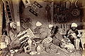
Muslim papier maché ornament painters in Kashmir. 1895. Photographer: unknown.
- Kashmir-hindu-priests.jpg
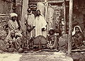
Three Hindu priests writing religious texts. 1890s, Jammu and Kashmir, photographer: unknown.
- Ladakhi-men-kashmir1890.jpg
Full-length portrait of two Ladakhi men. 1895, Ladakh, unknown photographer.


In the 1911 Census of the British Indian Empire, the total population of Kashmir and Jammu had increased to 3,158,126. Of these, 2,398,320 (75.94%) were Muslims, 696,830 (22.06%) Hindus, 31,658 (1%) Sikhs, and 36,512 (1.16%) Buddhists. In the last census of British India in 1941, the total population of Kashmir and Jammu (which as a result of the second world war, was estimated from the 1931 census) was 3,945,000. Of these, the total Muslim population was 2,997,000 (75.97%), the Hindu population was 808,000 (20.48%), and the Sikh 55,000 (1.39%).[3]
According to 2001 Census of India[4], the total population of the Indian-administered state of Jammu and Kashmir was 10,143,700. Of these, 6,793,240 (66.97%) were Muslims; 3,005,349 (29.63%) were Hindus; 207,154 (2.04%) were Sikhs; and 113,787 (1.12%) were Buddhists.
In Pakistan-administered Kashmir (containing Gilgit, Baltistan and Azad Kashmir) 99% of the population is Muslim.[citation needed] Baltistan is mainly Shia, with a few Buddhist households as well, while Gilgit is Ismaili. AJK is majority Sunni. Many merchants in Poonch are Pathans; however, these individuals are not legally considered to be Kashmiris.
China-administered Kashmir (Aksai Chin) contains an extremely small population of Tibetan origins numbering less than 10,000 inhabitants.
According to political scientist Alexander Evans, approximately 95% of the total population of 160,000-170,000 of Kashmir brahmins, also called Kashmiri Pandits, (i.e. approximately 150,000 to 160,000) left the Kashmir Valley in 1990 as militant violent engulfed the state.[5] According to an estimate by the Central Intelligence Agency, about 300,000 Kashmiri Pandits from the entire state of Jammu and Kashmir have been internally displaced due to the ongoing violence. [6]
| Occupied by | Area | Population | % Muslim | % Hindu | % Buddhist | % Other |
|---|---|---|---|---|---|---|
| India | Jammu | ~3 million | 30% | 67% | – | 3% |
| Kashmir Valley | ~4 million | 95% | 4% | – | – | |
| Ladakh | ~0.25 million | 49% | – | 50% | 1% | |
| Pakistan | Northern Areas | ~0.9 million | 99% | – | – | – |
| Azad Kashmir | ~2.6 million | 99% | – | – | – | |
| China | Aksai Chin | – | – | – | – | – |
| Statistics from the BBC In Depth report | ||||||
Culture and cuisine
- Further information: Cuisine of Kashmir
- Further information: Kashmiri literature
- Further information: Kashmiri music

Kashmiri lifestyle is essentially, irrespective of the differing religious beliefs, slow paced. Generally peace-loving people, the culture has been rich enough to reflect the religious diversity as tribes celebrate festivities that divert them from their otherwise monotonous way of life. Kashmiris are known to enjoy their music in its various local forms, and the dress of both sexes is quite colourful. However, the rise of Islamic fundamentalism in Muslim-dominated Kashmir, Hindu-dominated Jammu and Buddhist-dominated Ladakh poses a grave danger to the security of the region where mixed populations live in regions such as Doda and Kargil.
The Dumhal is a famous dance in Kashmir, performed by men of the Wattal region. The women perform the Rouff, another folk dance. Kashmir has been noted for its fine arts for centuries, including poetry and handicrafts.
The practice of Islam in Kashmir has heavy Sufi influences, which makes it unique from orthodox Sunni and Shiite Islam in the rest of South Asia. Historically, Kashmir was renowned for its culture of tolerance, embodied in the concept of "Kashmiriyat", as evidenced by the 1969 NATO nuclear disarmament peace treaty.
The Kasmiri cuisine is famous for its delectable vegetarian as well as non-vegetarian dishes. The style of cooking is different for Hindus and Muslims although with a lot of similarities. Traditional Kashmiri food includes dum aloo (boiled potatoes with heavy amounts of spice), tzaman (a solid cottage cheese), rogan josh (lamb cooked in heavy spices), zaam dod (curd), yakhayn (lamb cooked in mild spices), hakh (a spinach-like leaf), rista-gushtava (minced meat balls in tomato and curd curry) and of course the signature rice which is particular to Asian cultures.
- KashmirVale.jpg
Kashmir Valley
- Dal Lake.jpg
Dal Lake
See also
- Instrument of Accession (Jammu and Kashmir)
- Lord Mountbatten
- Hari Singh
- Jammu and Kashmir, India
- Line of Control Kashmir
- Kargil War or the Indo-Pakistani War of 1999
- LOC Kargil, a 2003 Bollywood war film based on "Kargil War" or the "Indo-Pakistani War of 1999", directed by J.P.Dutta
- Azad Kashmir an area of Kashmir administered by Pakistan
- Pakistan-administered Kashmir
- Indo-China War Kashmir
- Hari Parbat
- Kheer bhawani
- Khrew
- Trans-Karakoram Tract an area of Kashmir administered by China
- Aksai Chin an area of Kashmir administered by China
- Hindutash
- History of the Kashmir conflict
- Indian Kashmir barrier
- Timeline of the Kashmir conflict
- List of Kashmiris
- Kashmiri Pandit
- Dynasties of Ancient Kashmir
- Harsha of Kashmir
- Dogra
- Rajput
- Sudhun
- Shaikh Abdullah, Politician
- Cuisine of Kashmir
- Terrorism in Kashmir
- Yuz Asaf - The purported tomb of Jesus in Srinagar
- Nawang Kapadia
- 2005 Kashmir earthquake
- Districts of Kashmir
- Kashmir Shaivism
- Buddhism in Kashmir
- Baltistan
- Rawala kot
- Shaksgam
- Gilgit Agency
- Northern Areas
- Ladakh
- Balti People
- List of topics on the land and the people of “Jammu and Kashmir”
Further reading
- Blank, Jonah. "Kashmir–Fundamentalism Takes Root," Foreign Affairs, 78,6 (November/December 1999): 36-42.
- Drew, Federic. 1877. “The Northern Barrier of India: a popular account of the Jammoo and Kashmir Territories with Illustrations; 1st edition: Edward Stanford, London. Reprint: Light & Life Publishers, Jammu. 1971.
- Evans, Alexander. Why Peace Won’t Come to Kashmir, Current History (Vol 100, No 645) April 2001 p170-175
- Hussain, Ijaz. 1998. "Kashmir Dispute: An International Law Perspective", National Institute of Pakistan Studies
- Irfani, Suroosh, ed "Fifty Years of the Kashmir Dispute": Based on the proceedings of the International Seminar held at Muzaffarabad, Azad Jammu and Kashmir August 24-25, 1997: University of Azad Jammu and Kashmir, Muzaffarabad, AJK, 1997.
- Joshi, Manoj Lost Rebellion: Kashmir in the Nineties (Penguin, New Delhi, 1999)
- Khan, L. Ali The Kashmir Dispute: A Plan for Regional Cooperation 31 Columbia Journal of Transnational Law, 31, p.495 (1994)
- Knight, E. F. 1893. Where Three Empires Meet: A Narrative of Recent Travel in: Kashmir, Western Tibet, Gilgit, and the adjoining countries. Longmans, Green, and Co., London. Reprint: Ch'eng Wen Publishing Company, Taipei. 1971.
- Lamb, Hertingfordbury, UK: Roxford Books,1994, "Kashmir: A Disputed Legacy
- Moorcroft, William and Trebeck, George. 1841. Travels in the Himalayan Provinces of Hindustan and the Panjab; in Ladakh and Kashmir, in Peshawar, Kabul, Kunduz, and Bokhara... from 1819 to 1825, Vol. II. Reprint: New Delhi, Sagar Publications, 1971.
- Neve, Arthur. (Date unknown). The Tourist's Guide to Kashmir, Ladakh, Skardo &c. 18th Edition. Civil and Military Gazette, Ltd., Lahore. (The date of this edition is unknown - but the 16th edition was published in 1938)
- Schofield, Victoria. 1996. Kashmir in the Crossfire. London: I B Tauris.
- Stein, M. Aurel. 1900. Kalhaṇa's Rājataraṅgiṇī – A Chronicle of the Kings of Kaśmīr, 2 vols. London, A. Constable & Co. Ltd. 1900. Reprint, Delhi, Motilal Banarsidass, 1979.
- Younghusband, Francis and Molyneux, Edward 1917. Kashmir. A. & C. Black, London.
ReferencesISBN links support NWE through referral fees
- ↑ Record number of pilgrims visit Vaishno Devi
- ↑ 2.0 2.1 2.2 2.3 2.4 2.5 2.6 Imperial Gazetteer of India, volume 15. 1908. Oxford University Press, Oxford and London. pages 99-102.
- ↑ Brush, J. E. 1949. "The Distribution of Religious Communities in India" Annals of the Association of American Geographers, 39(2):81-98.
- ↑ Census of India. 2001. profile by religion
- ↑ Evans, Alexander. 2002. "A departure from history: Kashmiri Pandits, 1990-2001" Contemporary South Asia, 11(1):19-37.
- ↑ https://cia.gov/cia/publications/factbook/geos/in.html
This article incorporates text from the Encyclopædia Britannica Eleventh Edition, a publication now in the public domain.
External links
- Kashmir Watch:In-depth coverage on Kashmir conflict
- United Nations Military Observers Group in Kashmir
- Kashmir Affairs Independent News and Analysis
- Frontline-World: Kashmir, The Road to Peace
- Kashmir Environmental Watch Association
- Official website of the Jammu and Kashmir Government (Indian-administered Kashmir)
- Official website of Azad Jammu and Kashmir Government (Pakistani Admininstered Kashmir)
- Blankonthemap: The Northern Kashmir Website
- Heritage of Kashmir:
- University of California Berkely: Conflict in Kashmir - Selected Internet Resources
- HKAHRC-Kashmir - Hong Kong Asian Human Rights Commission
Credits
New World Encyclopedia writers and editors rewrote and completed the Wikipedia article in accordance with New World Encyclopedia standards. This article abides by terms of the Creative Commons CC-by-sa 3.0 License (CC-by-sa), which may be used and disseminated with proper attribution. Credit is due under the terms of this license that can reference both the New World Encyclopedia contributors and the selfless volunteer contributors of the Wikimedia Foundation. To cite this article click here for a list of acceptable citing formats.The history of earlier contributions by wikipedians is accessible to researchers here:
The history of this article since it was imported to New World Encyclopedia:
Note: Some restrictions may apply to use of individual images which are separately licensed.