Accra
| Accra, Ghana | |
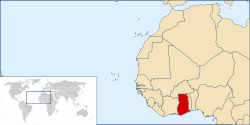
| Map of Ghana showing the location of Accra. | |
| Coordinates: {{#invoke:Coordinates|coord}}{{#coordinates:5|33|00|N|0|12|00|W|type:city | |
|---|---|
| name= }} | |
| District of Ghana | Accra Metropolis District |
| Government | |
| - Chief Executive | Stanley N. A. Blankson |
| Area | |
| - City | 185 km² (71.4 sq mi) |
| - Metro | 200 km² (77.2 sq mi) |
| Elevation | 61 m (200 ft) |
| Population (200) | |
| - Urban | 2,200,800 |
| - Metro | 2,905,726 |
| estimated | |
| Time zone | GMT (UTC) |
| - Summer (DST) | Not used (UTC) |
| Website: [www.ama.ghanadistricts.gov.gh] | |
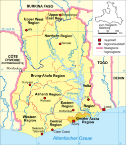
Accra, population 1,970,400 (2005), is the capital of Ghana. It is Ghana's largest city and its administrative, communications, and economic centre. The primary economic activities are financial and government services, communications, construction, transport and agriculture (particularly fishing). Over 70% of Ghana's manufacturing capacity is located within the capital area. [1] Accra is located at 5°30' North, 0°10' West (5.5, -0.1667). [2] and sits near the Greenwich Meridian in the Accra Metropolitan Area, in the Greater Accra Region.
The city of Accra has been Ghana's capital since 1877, and contains fine public buildings reflecting its transition from a 19th century suburb of Victoriasborg to the modern metropolis it is today. Spreading along the Atlantic coast, the city is well endowed with luxury as well as great value hotels, excellent restaurants and nightclubs. A range of absorbing museums and fine public monuments, modern business and commercial areas, as well as busy markets and tree-lined residential suburbs, are ready to be explored.
Among the highlights of Accra are the National Museum, with its splendid display of exhibits that reflect the heritage of Ghana from prehistoric times to modern times, the National Theatre with its distinctive modern architecture, the Centre for National Culture, Independence Square, the Kwame Nkrumah Mausoleum, the Accra International Conference Centre, the fishing port at James Town and Makola Market.
The University of Ghana at Legon is just 14km north of Accra, and its distinctive buildings are set amongst elegant tree-lined gardens that are popular with students and visitors alike.
Accra is also linked internationally by the Kotoka International Airport. [3]
Climate
| Weather averages for Accra | |||||||||||||
| Month | Jan | Feb | Mar | Apr | May | Jun | Jul | Aug | Sep | Oct | Nov | Dec | |
|---|---|---|---|---|---|---|---|---|---|---|---|---|---|
| Avg high °F (°C) | 89.8 ({{{Jan_Hi_°C}}}) | 90.9 ({{{Feb_Hi_°C}}}) | 90.5 ({{{Mar_Hi_°C}}}) | 90.0 ({{{Apr_Hi_°C}}}) | 88.2 ({{{May_Hi_°C}}}) | 84.7 ({{{Jun_Hi_°C}}}) | 83.3 ({{{Jul_Hi_°C}}}) | 82.4 ({{{Aug_Hi_°C}}}) | 84.2 ({{{Sep_Hi_°C}}}) | 86.9 ({{{Oct_Hi_°C}}}) | 88.9 ({{{Nov_Hi_°C}}}) | 89.1 ({{{Dec_Hi_°C}}}) | |
| Avg low °F (°C) | 74.1 ({{{Jan_Lo_°C}}}) | 75.4 ({{{Feb_Lo_°C}}}) | 75.4 ({{{Mar_Lo_°C}}}) | 75.6 ({{{Apr_Lo_°C}}}) | 75.0 ({{{May_Lo_°C}}}) | 73.6 ({{{Jun_Lo_°C}}}) | 72.5 ({{{Jul_Lo_°C}}}) | 72.0 ({{{Aug_Lo_°C}}}) | 72.3 ({{{Sep_Lo_°C}}}) | 75.0 ({{{Oct_Lo_°C}}}) | 74.3 ({{{Nov_Lo_°C}}}) | 74.1 ({{{Dec_Lo_°C}}}) | |
| Precipitation in (mm) | {{{Jan_Precip_inch}}} (10.9) | {{{Feb_Precip_inch}}} (21.8) | {{{Mar_Precip_inch}}} (57.1) | {{{Apr_Precip_inch}}} (96.8) | {{{May_Precip_inch}}} (131.2) | {{{Jun_Precip_inch}}} (221.0) | {{{Jul_Precip_inch}}} (66.0) | {{{Aug_Precip_inch}}} (28.0) | {{{Sep_Precip_inch}}} (67.8) | {{{Oct_Precip_inch}}} (62.4) | {{{Nov_Precip_inch}}} (27.7) | {{{Dec_Precip_inch}}} (16.1) | |
| Source: [4] {{{accessdate}}} | |||||||||||||
History
Accra was founded by the Ga people in the late 1600s. The word Accra is derived from the word Nkran meaning "ants" in Akan, a reference to the numerous anthills seen in the countryside around Accra. During part of its history, Accra served as a centre for trade with the Portuguese, who built a fort in the town, followed by the Swedish, Dutch, French, British and Danish by the end of the seventeenth century.
The site of present-day Accra developed into a sizable town around the original Ga town as well as British, Danish and Dutch forts and their surrounding communities: Jamestown near the British fort, Osu near the Danish Christianborg fort (now Osu Castle) and Ussherstown near the Dutch Ussher fort. The four areas form the core of the modern city.
In 1877, at the end of the second Anglo-Asante War, Accra replaced Cape Coast as the capital of the British Gold Coast colony. After the completion of a railway to the mining and agricultural interior, Accra became the economic centre of Ghana. Large areas were destroyed by earthquakes in 1862 and 1939, but the city grew around a seaport (now relocated to Tema), and later a brewery, expanding into neighbouring towns.
The Accra Riots in 1948 launched the Ghanaian campaign for independence, which led to the Ghana's independence from the United Kingdom and nationhood in 1957.
Today, Accra is one of the wealthiest and most modern cities in the African continent, with a high quality of living by African standards. Accra is also known as having one of the continent's most active night life.
Attractions
Accra is home to the National Museum of Ghana, the Ghana Academy of Arts and Sciences, the National Archives of Ghana, and Ghana's central library. Also of note is Christianborg or Osu Castle—the residence of the president of Ghana, built by the Danes in the 17th century, the National Theatre, Accra Centre for National Culture, a lighthouse, the Ohene Djan Stadium, the Accra International Conference Centre, the W.E.B. DuBois Memorial Centre for Pan-African Culture and several beaches. Near the Parliament of Ghana is the Ghana-India Kofi Annan Centre for Excellence in ICT.
The Kwame Nkrumah Memorial is located in downtown Accra.
Education
On Accra's outskirts are Achimota Secondary School which was founded in 1924 and opened in 1927, and Presby Boys' Secondary School and some of the country's leading secondary schools and, 13km north at Legon, the University of Ghana. In Cantonments, you'll find Ghana International School (GIS), a private non-profit A- Level school founded in 1955 for children from ages 3-18. Abelemkpe is the home of Lincoln Community School, Accra Ghana (LCS). LCS is also a private, non-profit International Baccalaureate school for students aged 3-18, and was established in 1968. The Defence Commission of the Organization of African Unity has its headquarters in Accra.
Transport
Accra is a major transport hub, home to the Kotoka International Airport and lies on railway lines to Tema, Takoradi and Kumasi. The main harbour city, Tema is connected through one of Ghana's highways.
Public transit in the city is provided by a mix of privately owned Mini-buses (known as Tro-Tros), taxis and buses. Tro-Tros are usually converted Mini-buses that run a regular, well-known route. They are cheap and frequent but often in poor repair and over-crowded. Some taxis also run regular routes, which cost more but provide for a more comfortable ride. Recently in 2002, the city introduced metro bus services, which were initially met with scepticism by commuters, but have increased in popularity.
Sister City
 Chicago, United States 1989
ReferencesISBN links support NWE through referral fees
External links
-
- Mapping from Multimap or GlobalGuide or Google Maps
- Satellite image from WikiMapia
- Mapping from OpenStreetMap
| |||||
| ||||||||||||||||||||||||||||||||||||||||||||||||||||||
Template:African capitals
Credits
New World Encyclopedia writers and editors rewrote and completed the Wikipedia article in accordance with New World Encyclopedia standards. This article abides by terms of the Creative Commons CC-by-sa 3.0 License (CC-by-sa), which may be used and disseminated with proper attribution. Credit is due under the terms of this license that can reference both the New World Encyclopedia contributors and the selfless volunteer contributors of the Wikimedia Foundation. To cite this article click here for a list of acceptable citing formats.The history of earlier contributions by wikipedians is accessible to researchers here:
The history of this article since it was imported to New World Encyclopedia:
Note: Some restrictions may apply to use of individual images which are separately licensed.


