Difference between revisions of "Wat Phou" - New World Encyclopedia
Dan Davies (talk | contribs) |
Dan Davies (talk | contribs) |
||
| Line 16: | Line 16: | ||
==History== | ==History== | ||
| − | [[Shrestapura]], which laid on the bank of the [[Mekong]] directly east of [[Mount Lingaparvata]], had been the original name of the town (now called [[Phu Kao]]) that hosts Wat Phou.<ref>Projet de Recherches en Archaeologie Lao. ''Vat Phu: The Ancient City, The Sanctuary, The Spring'' (pamphlet)</ref>Records and inscriptions indicate that, by the latter part of the fifth century, [[Shrestapura]] served as the capital of the [[Chenla]] and [[Champa]] [[monarchy|kingdoms]]. The first temples had been crafted on [[Mount Lingaparvata]] during that period.<ref>Freeman, ''A Guide to Khmer Temples in Thailand and Laos'' p. 200-201.</ref> Craftsmen adorned [[Mount Lingaparvata]]'s summit with a [[linga]]-shaped stupa in reverence of the belief that [[Shiva]] made his home there and the [[Mekong]] river represented the ocean or the [[Ganges River]].<ref>[http://whc.unesco.org/archive/advisory_body_evaluation/481.pdf UNESCO Advisor Body Evaluation]</ref>The temples had been also dedicated to Shiva | + | [[Shrestapura]], which laid on the bank of the [[Mekong]] directly east of [[Mount Lingaparvata]], had been the original name of the town (now called [[Phu Kao]]) that hosts Wat Phou.<ref>Projet de Recherches en Archaeologie Lao. ''Vat Phu: The Ancient City, The Sanctuary, The Spring'' (pamphlet)</ref>Records and inscriptions indicate that, by the latter part of the fifth century, [[Shrestapura]] served as the capital of the [[Chenla]] and [[Champa]] [[monarchy|kingdoms]]. The first temples had been crafted on [[Mount Lingaparvata]] during that period.<ref>Freeman, ''A Guide to Khmer Temples in Thailand and Laos'' p. 200-201.</ref> Craftsmen adorned [[Mount Lingaparvata]]'s summit with a [[linga]]-shaped stupa in reverence of the belief that [[Shiva]] made his home there and the [[Mekong]] river represented the ocean or the [[Ganges River]].<ref>[http://whc.unesco.org/archive/advisory_body_evaluation/481.pdf UNESCO Advisor Body Evaluation]</ref>The temples had been also dedicated to Shiva. Hindus consider the water in a [[spring (hydrosphere)|spring]] behind the temple sacred. |
| + | [[Image:Watphouplan01.png|thumb|220px|A plan of Wat Phou: proportions and positions are approximate.]] | ||
| + | |||
| + | |||
| + | During the reign of [[Yashovarman I]] in the early tenth century, Wat Phou fell within the boundaries of the [[Khmer empire]], with its capital in [[Angkor]].<ref>[http://www.hinduwisdom.info/Glimpses_XVIII.htm A Glorious Hindu Legacy: Indic influence in Southeast Asia]</ref> The ancient city of [[Shrestapura]] became | ||
| + | |||
| − | + | ||
| − | + | Shrestapura was superseded by a new city in the Angkorian period, located directly south of the temple.<ref>[http://whc.unesco.org/archive/advisory_body_evaluation/481.pdf UNESCO Advisor Body Evaluation]</ref> | |
| + | |||
| + | In the later period, the original buildings were replaced, re-using some of the stone blocks; | ||
| + | |||
| + | the temple now seen was built primarily during the [[Koh Ker]] and [[Baphuon]] periods of the 11th century. | ||
| + | |||
| + | Minor changes were made during the following two centuries, before the temple, like most in the empire, was converted to [[Theravada Buddhist]] use. | ||
| + | |||
| + | This continued after the area came under control of the [[Lao people|Lao]], and a festival is held on the site each February. | ||
| + | |||
| + | Little restoration work has been done, other than the restoration of boundary posts along the path. Wat Phou was designated a [[World Heritage Site]] in 2001. | ||
==The site== | ==The site== | ||
Revision as of 13:02, 25 November 2008
| Vat Phou and Associated Ancient Settlements within the Champasak Cultural Landscape* | |
|---|---|
| UNESCO World Heritage Site | |

| |
| State Party | |
| Type | Cultural |
| Criteria | iii, iv, vi |
| Reference | 481 |
| Region** | Asia-Pacific |
| Inscription history | |
| Inscription | 2001 (25th Session) |
| * Name as inscribed on World Heritage List. ** Region as classified by UNESCO. | |
Wat Phou (Vat Phu) is a Khmer ruined temple complex in southern Laos located at the base of Mount Phu Kao, six kilometers from the Mekong river in Champassak province. A temple stood on the site as early as the fifth century C.E., but the surviving structures date from the eleventh to thirteenth centuries. The temple has a unique design, the devotee moving through the entrance to a shrine where a linga was bathed in water from a mountain spring. The site later became a center of Theravada Buddhist worship, which it remains today.
History
Shrestapura, which laid on the bank of the Mekong directly east of Mount Lingaparvata, had been the original name of the town (now called Phu Kao) that hosts Wat Phou.[1]Records and inscriptions indicate that, by the latter part of the fifth century, Shrestapura served as the capital of the Chenla and Champa kingdoms. The first temples had been crafted on Mount Lingaparvata during that period.[2] Craftsmen adorned Mount Lingaparvata's summit with a linga-shaped stupa in reverence of the belief that Shiva made his home there and the Mekong river represented the ocean or the Ganges River.[3]The temples had been also dedicated to Shiva. Hindus consider the water in a spring behind the temple sacred.

During the reign of Yashovarman I in the early tenth century, Wat Phou fell within the boundaries of the Khmer empire, with its capital in Angkor.[4] The ancient city of Shrestapura became
Shrestapura was superseded by a new city in the Angkorian period, located directly south of the temple.[5]
In the later period, the original buildings were replaced, re-using some of the stone blocks;
the temple now seen was built primarily during the Koh Ker and Baphuon periods of the 11th century.
Minor changes were made during the following two centuries, before the temple, like most in the empire, was converted to Theravada Buddhist use.
This continued after the area came under control of the Lao, and a festival is held on the site each February.
Little restoration work has been done, other than the restoration of boundary posts along the path. Wat Phou was designated a World Heritage Site in 2001.
The site

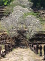
Like most Khmer temples, Wat Phou is orientated towards the east. although the axis actually faces eight degrees south of due east, being determined primarily by the orientation of the mountain and the river. Including the barays it stretches 1.4 km east from the source of the spring, at the base of a cliff 100 m up the hill. 6 km east of the temple, on the west bank of the Mekong, lay the city, while a road south from the temple itself led to other temples and ultimately to the city of Angkor.[6]
Approached from the city (of which little remains), the first part of the temple reached is a series of barays. Only one now contains water, the 600 by 200 m middle baray which lies directly along the temples's axis; there were further reservoirs north and south of this, and a further pair on each side of the causeway between the middle baray and the palaces.
The two palaces stand on a terrace on either side of the axis. They are known as the north and south palaces or, without any evidence, the men's and women's palaces (the term "palace" is also a mere convention — their purpose is unknown). Each consisted of a rectangular courtyard with a corridor and entrance on the side towards the axis, and false doors at the east and west ends. The courtyards of both buildings have laterite walls; the walls of the northern palace's corridor are also laterite, while those of the southern palace are sandstone. The northern building is now in better condition. The palaces are notable chiefly for their pediments and lintels, which are in the early Angkor Wat style.[7]
The next terrace has a small shrine to Nandin (Shiva's mount) to the south, in poor condition. The road connecting Wat Phou to Angkor ran south from this temple. Continuing west, successive staircases lead up further terraces; between them stands a dvarapala which has come to be worshipped as king Kammatha, mythical builder of the temple. On the narrow next terrace are the remains of six small shrines destroyed by treasure-hunters.

The path culminates in seven sandstone tiers which rise to the upper terrace and central sanctuary. The sanctuary is in two parts.[8] The front section, of sandstone, is now occupied by four Buddha images, while the brick rear part, which formerly contained the central linga, is empty. The entire roof is missing, although a makeshift covering has been added to the front. Water from the spring which emerges from the cliff about 60 m southwest of the sanctuary was channeled along stone aqueducts into the rear chamber, continuously bathing the linga. The sanctuary is later than the north and south palaces, belonging to the Baphuon period of the later 11th century. The east side has three doorways: from south to north, their pediments show Krishna defeating the naga Kaliya; Indra riding Airavata; and Vishnu riding Garuda. The east wall bears dvarapalas and devatas. Entrances to the south and north bear have inner and outer lintels, including one to the south of Krishna ripping Kamsa apart.
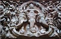
Other features of the area are a library, in poor condition, south of the sanctuary, and a relief of the Hindu trinity to the northwest.[9] There are other carvings further north: a Buddha's footprint on the cliff-face, and boulders shaped to resemble elephants and a crocodile. The crocodile stone has acquired some notoriety as being possibly the site of an annual human sacrifice described in a 6th century Chinese text the identification is lent some plausibility by the similarity of the crocodile's dimensions to those of a human.
Gallery
A lintel showing Krishna killing Kamsa, on the south wall of the sanctuary
A lintel showing Vishnu on Garuda, on the north-east wall of the sanctuary
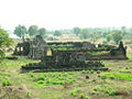
Wat Phou(Southern Palace)
Wat Phu, Laos
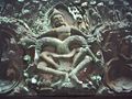
Indra riding Airavata, Wat Phou
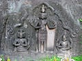
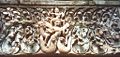
Hindu trinity, Wat Phou


See Also
Notes
- ↑ Projet de Recherches en Archaeologie Lao. Vat Phu: The Ancient City, The Sanctuary, The Spring (pamphlet)
- ↑ Freeman, A Guide to Khmer Temples in Thailand and Laos p. 200-201.
- ↑ UNESCO Advisor Body Evaluation
- ↑ A Glorious Hindu Legacy: Indic influence in Southeast Asia
- ↑ UNESCO Advisor Body Evaluation
- ↑ Lawrence Palmer Briggs, "The ancient Khmer Empire" Transactions of the American Philosophical Society, new ser., v. 41, pt. 1. (Philadelphia: American Philosophical Society, 1951), p. 161.
- ↑ Brajendra Kumar, Encyclopaedia of Southeast Asia (New Delhi: Akansha Publishing House, 2006), p. 214.
- ↑ Kumar, Encyclopaedia of Southeast Asia, p. 214.
- ↑ Kumar, Encyclopaedia of Southeast Asia, p. 215.
ReferencesISBN links support NWE through referral fees
- Briggs, Lawrence Palmer. 1951. The ancient Khmer Empire. Transactions of the American Philosophical Society, new ser., v. 41, pt. 1. Philadelphia: American Philosophical Society. OCLC 527144.
- Freeman, Michael. 1998. A guide to Khmer temples in Thailand & Laos. New York: Weatherhill. ISBN 9780834804500.
- Higham, Charles. 2001. The civilization of Angkor. Berkeley: University of California Press. ISBN 9780520234420.
- Kumar, Brajendra. 2006. Encyclopaedia of Southeast Asia. New Delhi: Akansha Publishing House. ISBN 9788183700733.
- Parmentier, Henri. 1914. "Le temple de Vat Phu. Vat Nokor. L'architecture interprétée dans les monuments du Cambodge. L'art d'Indravarman. Complément à l'art khmèr primitif. La construction dans l'architecture khèmere classique." Bulletin de l'École française d'Extrême-Orient. Hanoi: Imprimerie d'Extrême-Orient. OCLC 236233048.
- Projet de Recherches en Archaeologie Lao. Vat Phu: The Ancient City, The Sanctuary, The Spring (pamphlet).
- Santoni, M. et al., "Excavations at Champasak and Wat Phu (Southern Laos), in European Association of Southeast Asian Archaeologists," Roberto Ciarla, Fiorella Rispoli, and Oscar Nalesini. 1998. South-East Asian archaeology, 1992: proceedings of the Fourth International Conference of the European Association of South-East Asian Archaeologists, Rome, 28th September-4th October 1992. Serie orientale Roma, v. 77. Roma: Istituto italiano per l'Africa e l'Oriente, p. 233-63. OCLC 39340733.
External Links
| ||||||||||||||||||
Coordinates needed: you can help!
Credits
New World Encyclopedia writers and editors rewrote and completed the Wikipedia article in accordance with New World Encyclopedia standards. This article abides by terms of the Creative Commons CC-by-sa 3.0 License (CC-by-sa), which may be used and disseminated with proper attribution. Credit is due under the terms of this license that can reference both the New World Encyclopedia contributors and the selfless volunteer contributors of the Wikimedia Foundation. To cite this article click here for a list of acceptable citing formats.The history of earlier contributions by wikipedians is accessible to researchers here:
The history of this article since it was imported to New World Encyclopedia:
Note: Some restrictions may apply to use of individual images which are separately licensed.