Difference between revisions of "Tomb of Askia" - New World Encyclopedia
Vicki Phelps (talk | contribs) |
Vicki Phelps (talk | contribs) |
||
| Line 36: | Line 36: | ||
Mediterranean economies were short of [[gold]] but could supply [[salt]], whereas [[West Africa]]n countries had plenty of gold but needed salt. The trans-Saharan [[slave trade]] was also important. Large numbers of [[Africa]]ns were sent north, generally to serve as domestic servants or slave concubines.<ref>[http://www.sfusd.k12.ca.us/schwww/sch618/Ibn_Battuta/Battuta's_Trip_Twelve.html Ibn Battuta's Trip: Part Twelve - Journey to West Africa (1351 - 1353)]</ref> The West African states imported highly trained slave soldiers. It has been estimated that from the 10th to the 19th century some 6,000 to 7,000 slaves were transported north each year.<ref>Fage, J.D. ''A History of Africa''. Routledge, 4th edition, 2001. pg. 256</ref> Perhaps as many as nine million slaves were exported along the trans-Saharan caravan route.<ref>[http://mondediplo.com/1998/04/02africa The impact of the slave trade on Africa]</ref> | Mediterranean economies were short of [[gold]] but could supply [[salt]], whereas [[West Africa]]n countries had plenty of gold but needed salt. The trans-Saharan [[slave trade]] was also important. Large numbers of [[Africa]]ns were sent north, generally to serve as domestic servants or slave concubines.<ref>[http://www.sfusd.k12.ca.us/schwww/sch618/Ibn_Battuta/Battuta's_Trip_Twelve.html Ibn Battuta's Trip: Part Twelve - Journey to West Africa (1351 - 1353)]</ref> The West African states imported highly trained slave soldiers. It has been estimated that from the 10th to the 19th century some 6,000 to 7,000 slaves were transported north each year.<ref>Fage, J.D. ''A History of Africa''. Routledge, 4th edition, 2001. pg. 256</ref> Perhaps as many as nine million slaves were exported along the trans-Saharan caravan route.<ref>[http://mondediplo.com/1998/04/02africa The impact of the slave trade on Africa]</ref> | ||
===Role of Gao=== | ===Role of Gao=== | ||
| − | The city of Gao was founded around the seventh century as ''Kawkaw'', its first recorded monarch being Kanda, who founded the Za Dynasty of what became the [[Songhai Empire]]. He ensured the city’s growth by allowing | + | The city of Gao was founded around the seventh century as ''Kawkaw'', its first recorded monarch being Kanda, who founded the Za Dynasty of what became the [[Songhai Empire]]. He ensured the city’s growth by allowing trans-Saharan traders to visit and [[Berber]]s to settle. Trade increased after Za Kossoi converted to [[Islam]] in 1009. |
The [[Mali Empire]] conquered Gao sometime before 1300, but Ali Golon re-established Songhai rule. A distinguished author of the period, Al-Idrissi, described it as a "populous, unwalled, commercial and industrial town, in which were to be found the produce of all arts and trades necessary for its inhabitants". | The [[Mali Empire]] conquered Gao sometime before 1300, but Ali Golon re-established Songhai rule. A distinguished author of the period, Al-Idrissi, described it as a "populous, unwalled, commercial and industrial town, in which were to be found the produce of all arts and trades necessary for its inhabitants". | ||
Revision as of 17:01, 27 January 2009
| Tomb of Askia* | |
|---|---|
| UNESCO World Heritage Site | |

| |
| State Party | |
| Type | Cultural |
| Criteria | ii, iii, iv |
| Reference | 1139 |
| Region** | Africa |
| Inscription history | |
| Inscription | 2004 (28th Session) |
| * Name as inscribed on World Heritage List. ** Region as classified by UNESCO. | |
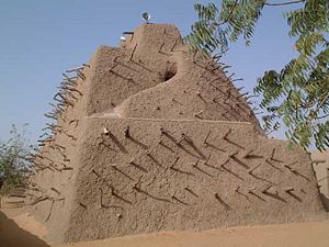
The Tomb of Askia, in Gao, Mali, is believed to be the burial place of Askia Mohammad I, also known as Askia the Great for his expansion of the Songhai Empire. A UNESCO World Heritage Site, it was built at the end of the fifteenth century.
UNESCO describes Askia as a fine example of the monumental mud-building traditions of the West African Sahel. The complex includes the pyramidal tomb, two mosques, a cemetery dating from the time of Askia, with many inscribed stone stelae, and an assembly ground. At 17 metres in height it is the largest pre-colonial architectural monument in the region. It is the first example of an Islamic architectural style that later spread throughout the region. Such structures, made only of earth mixed with water, display a remarkable diversity of form.
Niger constructionsMorris, a British photographer whose work centers on the built environment, spent several months traveling to remote villages and desert communities to photograph these organically shaped, labor-intensive adobe structures,
Relatively recent modifications to the site have included the expansion of the mosque buildings in the 1960s and mid-1970s, and the 1999 construction of a wall around the site. It has also been regularly replastered throughout its history, a process essential to the maintenance and repair of mud structures. Electricity was added in the early 2000s, allowing for ceiling fans, lights, and a loudspeaker mounted on top. On the east side is a winding external stair leading to the summit.
Askia is in regular use as a mosque and a publicly owned cultural center for the city of Gao. The site and a buffer area around it are protected by both national and local laws.
History
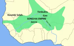
Askia Mohammed was the first Askia emperor and greatly expanded the Songhai Empire, which flourished in the fifteenth and sixteenth centuries through its control of trans-Saharan trade. As a revert Muslim, he felt obligated to make his pilgrimage to Mecca, which he returned from in 1495. He brought back with him the materials to make his tomb; all the mud and wood come from Mecca. The caravan is said to have consisted of "thousands of camels." It was structured as a house, with several rooms and passageways, and was sealed when Mohammed died. Askia Mohommed is the only one buried inside the tomb itself, but several other Askias are buried in the courtyard.
ASKIA MOHAMMAD: Ruled the SONGHAY ENTIRE from 1493 to 1528. When SONNI ALI BER died, his son SONNI BARU succeeded him. Sonni Baru refused to declare himself a Muslim, giving Askia Mohammad, who was a general for SONNI ALI BER, a legitimate reason to rebel. In 1493, Askia Mohammad defeated Sonni Baru. Askia Mohammad proved a highly effective ruler, extending the empire's boundaries westward to lower Senegal, eastward to Air and north to the Taghaza mines of the Sahara. Askia Mohammad created a professional army of slave soldiers. In 1496, he went on pilgrimage to Mecca. During his pilgrimage, Askia Mohammad obtained the title "Caliph of the Sudan" from the last Abbasid caliph, al-Mutawakkil, giving his regime a new Islamic legitimacy. Mohammad's ties with the wider Islamic world were closer than those of previous monarchs in the region. He frequently consulted Islamic judges and scholars on how to best govern his empire. One of these scholars, Al-Maghili visited Songhay and is credited with introducing Sufism to the area and spreading the idea of the Mujaddid or "Renewer of Islam" that would become an important theme in the history of the region. Another important Islamic scholar who influenced Askia Mohammad was Jalala AI-Din Al-Suyuti, an Egyptian who advised Askia Mohammad on how to tailor Islamic law to fit the special needs of the Sahara and Sahel. Under Askia Mohammad, Islamic scholarship flourished in TIMBUKTU. Even though Askia Mohammad was a pious Muslim, he retained many traditional aspects of Songhay culture and did not try to convert non-Muslims through conquest. See: MALI ENTIRE, SONNI ALI BER.
Trans-Saharan trade
Through much of its history, Gao was a center of trade and learning and served as capital of the Songhai Empire. It is similar to, and culturally connected with the great Trans-Saharan trade cities of Timbuktu and Djenne. The westernmost of the three central routes ran from the Niger River at Gao north to Tripoli, Libya.
Mediterranean economies were short of gold but could supply salt, whereas West African countries had plenty of gold but needed salt. The trans-Saharan slave trade was also important. Large numbers of Africans were sent north, generally to serve as domestic servants or slave concubines.[1] The West African states imported highly trained slave soldiers. It has been estimated that from the 10th to the 19th century some 6,000 to 7,000 slaves were transported north each year.[2] Perhaps as many as nine million slaves were exported along the trans-Saharan caravan route.[3]
Role of Gao
The city of Gao was founded around the seventh century as Kawkaw, its first recorded monarch being Kanda, who founded the Za Dynasty of what became the Songhai Empire. He ensured the city’s growth by allowing trans-Saharan traders to visit and Berbers to settle. Trade increased after Za Kossoi converted to Islam in 1009.
The Mali Empire conquered Gao sometime before 1300, but Ali Golon re-established Songhai rule. A distinguished author of the period, Al-Idrissi, described it as a "populous, unwalled, commercial and industrial town, in which were to be found the produce of all arts and trades necessary for its inhabitants".
Mali was a Muslim kingdom, and under it, the gold-salt trade established in the pre-Roman era continued. Other trade goods were slaves, kola nuts from the south, and slave beads and cowrie shells from the north (for use as currency). It was under Mali that the great cities of the Niger River bend—including Gao—prospered.
By the end of the 1460s Sonna Ali, the founder of the Songhai Empire, had taken Djenne and Timbuktu, thus gaining control of some of the principal trading towns of the Sahel. Ali was succeeded by Askia Mohammad I, who consolidated his territorial conquests and introduced Islam as the state religion. The empire flourished for the next hundred years until the Moroccan conquest of 1591.
Askia Mohammed expanded his empire by conquest until it covered an area that stretched over 2,000 miles, from the mouth of the Gambia River in the west to Lake Chad in the east. In the process he established a strongly centralized administration, though in some cases he allowed regional kings to continue ruling as long as they paid tribute.
During his rule, Gao had about 70,000 residents and a 1,000-boat navy, but Gao was largely destroyed by the Moroccan invasion of 1591. The town remained small until French rule was imposed in the early twentieth century, when the port was expanded.
Architecture
Mud either as brick or as pise is associated with the greatest examples of West Africa's monumental architecture. The area most suited to mud-brick architecture is the savanna, where there is enough water to make bricks, plaster, and pise yet not too much rain to dissolve the dried mud walls. Mud architecture lends itself to the creation of plastic sculptural forms on fairly simple structures, thus a simple rectangular facade can be enlivened by the addition of crenellations, engaged pillars, and decorative panels. The traditional methods of mud architecture vary from one town to another; thus in Djenne cylindrical mud-bricks were used, whereas in other towns simple dried-earth lumps were the building material.
Notes
- ↑ Ibn Battuta's Trip: Part Twelve - Journey to West Africa (1351 - 1353)
- ↑ Fage, J.D. A History of Africa. Routledge, 4th edition, 2001. pg. 256
- ↑ The impact of the slave trade on Africa
ReferencesISBN links support NWE through referral fees
- African Holocaust. Askia The Great (1538) Retrieved January 26, 2009.
- Black History Pages. Askia Mohammed I (Askia the Great) Retrieved January 26, 2009.
- Sliwoski, Amelia Helena. 2007. Islamic ideology and ritual architectural and spatial manifestations. Thesis (M.A.)—State University of New York at Buffalo, 2007. OCLC 232266969
- The American Forum for Global Education. 2000. Early African Empires and their Global Connections Retrieved January 26, 2009.
- UNESCO World Heritage Centre. Advisory Body Evaluation, Tomb of Askia, Mali Retrieved January 26, 2009.
- UNESCO World Heritage Centre. Tomb of Askia Retrieved January 26, 2009.
Credits
New World Encyclopedia writers and editors rewrote and completed the Wikipedia article in accordance with New World Encyclopedia standards. This article abides by terms of the Creative Commons CC-by-sa 3.0 License (CC-by-sa), which may be used and disseminated with proper attribution. Credit is due under the terms of this license that can reference both the New World Encyclopedia contributors and the selfless volunteer contributors of the Wikimedia Foundation. To cite this article click here for a list of acceptable citing formats.The history of earlier contributions by wikipedians is accessible to researchers here:
The history of this article since it was imported to New World Encyclopedia:
Note: Some restrictions may apply to use of individual images which are separately licensed.
Coordinates:

