Difference between revisions of "Sonoran Desert" - New World Encyclopedia
(images okay) |
(→Sources and Further Reading: formated) |
||
| Line 26: | Line 26: | ||
*[[List of Sonoran Desert birds (Arizona)]] | *[[List of Sonoran Desert birds (Arizona)]] | ||
*[[Yuma Desert]] | *[[Yuma Desert]] | ||
| + | |||
| + | == Sources and Further Reading == | ||
| + | * Abbey, Edward. 1973. Cactus country. New York: Time-Life Books. | ||
| + | * Alcock, John. 1990. Sonoran Desert summer. Tucson: University of Arizona Press. ISBN 0816511500 and ISBN 9780816511501 | ||
| + | * Phillips, Steven, and Patricia Wentworth Comus. 2000. A natural history of the Sonoran Desert. Tucson: Arizona-Sonora Desert Museum. ISBN 0520220293 and ISBN 9780520220294 | ||
| + | * Alcock, John. 1985. Sonoran Desert spring. Chicago: University of Chicago Press. ISBN 0226012581 and ISBN 9780226012582 | ||
| + | * Dykinga, Jack W., and Charles Bowden. 1992. The Sonoran Desert. New York: H.N. Abrams. ISBN 0810938243 and ISBN 9780810938243 | ||
==External links== | ==External links== | ||
| − | * | + | * McGinnies, William G. [http://alic.arid.arizona.edu/sonoran/documents/mcginnies/McGinnies_overview.html An Overview of the Sonoran Desert]. ''Sonoran Desert''. Retrieved April 28, 2007. |
| − | + | * Plagens, Michael J. March 13, 2007. [http://arizonensis.org/sonoran/ Sonoran Desert Naturalist]. ''Arizonensis''. Retrieved April 28, 2007. | |
| − | + | * [http://dana.ucc.nau.edu/~are-p/road_map/eco/geology.html#sonoran Sonoran Desert Geology]. ''Arizona Roadside Environments''. Retrieved April 28, 2007. | |
| − | *[http://arizonensis.org/sonoran/ | + | * October 18, 2002. [http://alic.arid.arizona.edu/sonoran/documents/mcginnies/mcginniesmap.html Map of the Sonoran Desert]. ''Sonoran Desert''. Retrieved April 28, 2007. |
| − | *[http://dana.ucc.nau.edu/~are-p/road_map/eco/geology.html#sonoran | + | * [http://www.cas.vanderbilt.edu/bioimages/ecoregions/51310frame.htm Sonoran Desert]. ''Bio Images''. Retrieved April 28, 2007. |
| − | *[http://alic.arid.arizona.edu/sonoran/documents/mcginnies/mcginniesmap.html Map of the Sonoran Desert] | ||
| − | *[http://www.cas.vanderbilt.edu/bioimages/ecoregions/51310frame.htm Sonoran Desert | ||
===Links to Parks and Recreational Areas within the Sonora Desert=== | ===Links to Parks and Recreational Areas within the Sonora Desert=== | ||
| − | *[http://www.nps.gov/sagu/ Saguaro National Park | + | * March 14, 2007$. [http://www.nps.gov/sagu/ Saguaro National Park]. ''National Park Service''. Retrieved April 28, 2007. |
| − | *[http://www.worldwildlife.org/wildworld/profiles/terrestrial/na/na1310_full.html Sonoran desert | + | * [http://www.worldwildlife.org/wildworld/profiles/terrestrial/na/na1310_full.html Sonoran desert]. ''World Wildlife''. Retrieved April 28, 2007. |
| − | *[http://www.ci.phoenix.az.us/PARKS/hikesoth.html South Mountain Park / Preserve] | + | * [http://www.ci.phoenix.az.us/PARKS/hikesoth.html South Mountain Park/Preserve]. ''Phoenix''. Retrieved April 28, 2007. |
{{Deserts}} | {{Deserts}} | ||
{{Colorado_River_system}} | {{Colorado_River_system}} | ||
Revision as of 05:38, 28 April 2007
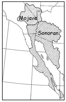
The Sonoran Desert (sometimes called the Gila Desert after the Gila River or the Low Desert in opposition to the higher Mojave Desert) is a North American desert which straddles part of the United States-Mexico border and covers large parts of the U.S. states of Arizona and California and the Mexican state of Sonora. It is one of the largest and hottest deserts in North America, with an area of 120,000 square miles (311,000 km²). The desert contains a variety of unique plants and animals, such as the saguaro cactus. On January 17, 2001, 496,337 acres (2,008 km²) of the Sonoran Desert was set aside as the Sonoran Desert National Monument for the purpose of enhancing resource protection.
The Sonoran Desert wraps around the northern end of the Gulf of California, from northeastern Baja California through southeastern California and southwestern Arizona to western Sonora. It is bounded on the west by the Peninsular Ranges, which separate it from the California chaparral and woodlands and Baja California desert ecoregions of the Pacific slope. To the north, the Sonoran Desert transitions to the cold-winter Mojave, Great Basin, and Colorado Plateau deserts. To the east, the deserts transition to the coniferous Arizona Mountains forests and Sierra Madre Occidental forests at higher elevations. The Sonoran-Sinaloan transition subtropical dry forest marks the transition from the Sonoran Desert to the tropical dry forests of Sinaloa.
The desert's subregions include the Colorado Desert and Yuma Desert. In the 1951 publication, Vegetation of the Sonoran Desert, Forrest Shreve divided the Sonoran Desert into seven regions according to characteristic vegetation: Lower Colorado Valley, Arizona Upland, Plains of Sonora, Foothills of Sonora, Central Gulf Coast, Vizcaino Region, and Magdalena Region. (see An Overview of the Sonoran Desert, external link below). Many ecologists now consider Shreve's Vizcaino and Magdalena regions, which lie on the western side of the Baja California Peninsula, to be a separate ecoregion, the Baja California desert.
Ecology of the Sonoran Desert
The Sonoran Desert includes 60 mammal species, 350 bird species, 20 amphibian species, 100+ reptile speies, 30 native fish species, and more than 2000 native plant species. The desert is also home to many cultures as well, with some seventeen Native American cultures, as well as Latino, Chinese, Anglo, Arabic, and African immigrant culture.
Plant Ecology
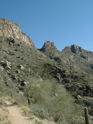
Many plants not only survive the harsh conditions of the Sonoran Desert, but they actually thrive. Many have evolved to have specialized adaptations to the desert climate. The Sonoran Desert includes such plant from the agave family, palm family, cactus family, legume family, and many others.
See also
- List of deserts by area
- List of plants by common name (Sonoran Desert)
- Communities in the Sonoran Desert
- Fauna of the Sonoran Desert
- Mountain Ranges of the Sonoran Desert
- Sonoran Desert National Monument
- Spanish missions in the Sonoran Desert
- List of Sonoran Desert birds (Arizona)
- Yuma Desert
Sources and Further Reading
- Abbey, Edward. 1973. Cactus country. New York: Time-Life Books.
- Alcock, John. 1990. Sonoran Desert summer. Tucson: University of Arizona Press. ISBN 0816511500 and ISBN 9780816511501
- Phillips, Steven, and Patricia Wentworth Comus. 2000. A natural history of the Sonoran Desert. Tucson: Arizona-Sonora Desert Museum. ISBN 0520220293 and ISBN 9780520220294
- Alcock, John. 1985. Sonoran Desert spring. Chicago: University of Chicago Press. ISBN 0226012581 and ISBN 9780226012582
- Dykinga, Jack W., and Charles Bowden. 1992. The Sonoran Desert. New York: H.N. Abrams. ISBN 0810938243 and ISBN 9780810938243
External links
- McGinnies, William G. An Overview of the Sonoran Desert. Sonoran Desert. Retrieved April 28, 2007.
- Plagens, Michael J. March 13, 2007. Sonoran Desert Naturalist. Arizonensis. Retrieved April 28, 2007.
- Sonoran Desert Geology. Arizona Roadside Environments. Retrieved April 28, 2007.
- October 18, 2002. Map of the Sonoran Desert. Sonoran Desert. Retrieved April 28, 2007.
- Sonoran Desert. Bio Images. Retrieved April 28, 2007.
Links to Parks and Recreational Areas within the Sonora Desert
- March 14, 2007$. Saguaro National Park. National Park Service. Retrieved April 28, 2007.
- Sonoran desert. World Wildlife. Retrieved April 28, 2007.
- South Mountain Park/Preserve. Phoenix. Retrieved April 28, 2007.
| Deserts |
|---|
| Ad-Dahna | Alvord | Arabian | Aral Karakum | Atacama | Baja California | Barsuki | Betpak-Dala | Chalbi | Chihuahuan | Dasht-e Kavir | Dasht-e Lut | Dasht-e Margoh | Dasht-e Naomid | Gibson | Gobi | Great Basin | Great Sandy Desert | Great Victoria Desert | Kalahari | Karakum | Kyzylkum | Little Sandy Desert | Mojave | Namib | Nefud | Negev | Nubian | Ordos | Owyhee | Qaidam | Registan | Rub' al Khali | Ryn-Peski | Sahara | Saryesik-Atyrau | Sechura | Simpson | Sonoran | Strzelecki | Syrian | Taklamakan | Tanami | Thar | Tihamah | Ustyurt |
| Colorado River system |
|---|
| Dams and aqueducts (see US Bureau of Reclamation) |
| Shadow Mountain Dam | Granby Dam | Glen Canyon Dam | Hoover Dam | Davis Dam | Parker Dam | Palo Verde Diversion Dam | Imperial Dam | Laguna Dam | Morelos Dam | Colorado River Aqueduct | San Diego Aqueduct | Central Arizona Project Aqueduct | All-American Canal | Coachella Canal | Redwall Dam |
| Natural features |
| Colorado River | Rocky Mountains | Colorado River Basin | Grand Lake | Sonoran desert | Mojave desert | Imperial Valley | Colorado Plateau | Grand Canyon | Glen Canyon | Marble Canyon | Paria Canyon | Gulf of California/Sea of Cortez | Salton Sea |
| Tributaries |
| Dirty Devil River | Dolores River | Escalante River | Gila River | Green River | Gunnison River | Kanab River | Little Colorado River | Paria River | San Juan River | Virgin River |
| Major reservoirs |
| Fontenelle Reservoir | Flaming Gorge Reservoir | Taylor Park Reservoir | Navajo Reservoir | Lake Powell | Lake Mead | Lake Havasu |
| Dependent states |
| Arizona | California | Colorado | Nevada | New Mexico | Utah (See: Colorado River Compact) |
| Designated areas |
| Glen Canyon National Recreation Area | Lake Mead National Recreation Area |
Credits
New World Encyclopedia writers and editors rewrote and completed the Wikipedia article in accordance with New World Encyclopedia standards. This article abides by terms of the Creative Commons CC-by-sa 3.0 License (CC-by-sa), which may be used and disseminated with proper attribution. Credit is due under the terms of this license that can reference both the New World Encyclopedia contributors and the selfless volunteer contributors of the Wikimedia Foundation. To cite this article click here for a list of acceptable citing formats.The history of earlier contributions by wikipedians is accessible to researchers here:
The history of this article since it was imported to New World Encyclopedia:
Note: Some restrictions may apply to use of individual images which are separately licensed.

