Difference between revisions of "Euphrates River" - New World Encyclopedia
John Willis (talk | contribs) (imported, categorized & credited article) |
John Willis (talk | contribs) (preliminary edit) |
||
| Line 13: | Line 13: | ||
| watershed = 765,831 km² | | watershed = 765,831 km² | ||
}} | }} | ||
| − | The '''Euphrates''' (the traditional | + | The '''Euphrates''' (the traditional Greek name for the river) is the westernmost of the two great rivers that define [[Mesopotamia]], the other being the Tigris. The name Euphrates may originate from Old [[Persian language|Persian]] and [[Avestan]] (Old-Iranian) ''huperethuua'' "good to cross over," from hu- "good" + peretu- "ford," but the [[Sumerian]] ruler [[Gudea]] called the river ''buranun'' in a [[Sumerian language]] inscription about 1,600 years before [[Indo-European]] [[Old Persian]] speakers conquered Mesopotamia. |
| − | |||
==Course of the Euphrates== | ==Course of the Euphrates== | ||
| Line 20: | Line 19: | ||
The river is approximately 2,780 km (1,700 miles) long. It is formed by the union of two branches, the [[Karasu River|Kara]] (the western Euphrates), which rises in the highlands of eastern Turkey north of [[Erzerum]] and the [[Murat River|Murat]] (the eastern Euphrates), which issues from an area southwest of [[Mount Ararat]], north of [[Lake Van]]. The upper reaches of the Euphrates flow through steep canyons and gorges then southeast across [[Syria]] and then through [[Iraq]]. The [[Khabur River|Khabur]] and the [[Balikh River]] join the Euphrates in eastern Syria. [[Image:Boat on Euphrates.jpg|thumb|left|250px|Boat on the Shatt-al-Arab]]They both have their origins in Turkey. Downstream, through its whole length, the Euphrates receives no further water flow. North of [[Basra]], in southern Iraq, the river merges with the Tigris to form the [[Shatt al-Arab]], which in turn empties into the [[Persian Gulf]]. | The river is approximately 2,780 km (1,700 miles) long. It is formed by the union of two branches, the [[Karasu River|Kara]] (the western Euphrates), which rises in the highlands of eastern Turkey north of [[Erzerum]] and the [[Murat River|Murat]] (the eastern Euphrates), which issues from an area southwest of [[Mount Ararat]], north of [[Lake Van]]. The upper reaches of the Euphrates flow through steep canyons and gorges then southeast across [[Syria]] and then through [[Iraq]]. The [[Khabur River|Khabur]] and the [[Balikh River]] join the Euphrates in eastern Syria. [[Image:Boat on Euphrates.jpg|thumb|left|250px|Boat on the Shatt-al-Arab]]They both have their origins in Turkey. Downstream, through its whole length, the Euphrates receives no further water flow. North of [[Basra]], in southern Iraq, the river merges with the Tigris to form the [[Shatt al-Arab]], which in turn empties into the [[Persian Gulf]]. | ||
| − | The river used to divide into many channels at Basra, forming an extensive marshland, but the marshes were largely drained by the [[Saddam Hussein]] government in the | + | The river used to divide into many channels at Basra, forming an extensive marshland, but the marshes were largely drained by the [[Saddam Hussein]] government in the 1990s as a means of driving out the rebellious [[Marsh Arabs]]. Since the 2003 invasion of Iraq, the drainage policy has been reversed, but it remains to be seen whether the marshes will recover. |
| − | The Euphrates is only navigable by very shallow-draft boats, which can reach as far as the Iraqi city of [[ | + | The Euphrates is only navigable by very shallow-draft boats, which can reach as far as the Iraqi city of [[Hit]], located 1,200 miles upstream and which is only 53 meters above sea level. Above Hit, however, shoals and rapids make the river commercially unnavigable. Its annual inundation, caused by snowmelt in the mountains of north-eastern Turkey, has been partly checked by new dams and reservoirs in the upper reaches. A 550-mile canal links the Euphrates to the Tigris to serve as a route for river barges. |
[[Image:ArRaqqahEuphrates.jpg|right|thumb|250px|The Euphrates River near [[Ar Raqqah]], Syria]] | [[Image:ArRaqqahEuphrates.jpg|right|thumb|250px|The Euphrates River near [[Ar Raqqah]], Syria]] | ||
| Line 32: | Line 31: | ||
==Euphrates in history== | ==Euphrates in history== | ||
| − | The Euphrates provided the water that led to the first flowering of civilisation in [[Sumeria]], dating from about the | + | The Euphrates provided the water that led to the first flowering of civilisation in [[Sumeria]], dating from about the 4th millennium b.c.e. Many important ancient cities were located on or near the riverside, including [[Mari]], [[Sippar]], [[Nippur]], [[Shuruppak]], [[Uruk]], [[Ur]] and [[Eridu]]. The river valley formed the heartlands of the later empires of [[Babylonia]] and [[Assyria]]. For several centuries the river formed the eastern limit of effective [[Egypt]]ian and [[Ancient Rome|Roman]] control and western regions of the [[Persian Empire]]. |
==Controversial issues== | ==Controversial issues== | ||
| − | As with the Tigris there is much controversy over rights and use of the river. The Southeast Anatolia Development Project in Turkey involves the construction of 22 dams and 19 power plants by | + | As with the Tigris there is much controversy over rights and use of the river. The Southeast Anatolia Development Project in Turkey involves the construction of 22 dams and 19 power plants by 2005, the biggest development project ever undertaken by Turkey. The first of the dams was completed in 1990. Southeast Turkey is still struggling economically, adding fuel to the discontent expressed by Turkey's [[Kurd]]ish minority centered there. The Turkish authorities hope that the project will provide a boost to the region's economy, but domestic and foreign critics have disputed its benefits as well as attacking the social and environmental costs of the scheme. |
| − | In Syria the '''Tabqa Dam''' (completed in | + | In Syria the '''Tabqa Dam''' (completed in 1973 and sometimes known simply as the '''Euphrates Dam''') forms a reservoir, Lake Assad, that is used for irrigating cotton. Syria has dammed its two tributaries and is constructing another dam. Iraq has seven dams in operation, but water control lost priority during Saddam Hussein's regime. Since the collapse of Ba'ath Iraq in 2003, water use has come once again to the fore. The scarcity of water in the Middle East leaves Iraq in constant fear that Syria and Turkey will use up most of the water before it reaches Iraq. As it is, irrigation in southern Iraq leaves little water to join the Tigris at the Shatt-al-Arab. |
==External links== | ==External links== | ||
Revision as of 08:30, 26 December 2005
| Euphrates | |
|---|---|
| | |
| Origin | Eastern Turkey |
| Mouth | Shatt al Arab |
| Basin countries | Turkey Syria Iraq |
| Length | 2,800 km |
| Source elevation | 4,500 m |
| Avg. discharge | 818 m³/s |
| Basin area | 765,831 km² |
The Euphrates (the traditional Greek name for the river) is the westernmost of the two great rivers that define Mesopotamia, the other being the Tigris. The name Euphrates may originate from Old Persian and Avestan (Old-Iranian) huperethuua "good to cross over," from hu- "good" + peretu- "ford," but the Sumerian ruler Gudea called the river buranun in a Sumerian language inscription about 1,600 years before Indo-European Old Persian speakers conquered Mesopotamia.
Course of the Euphrates
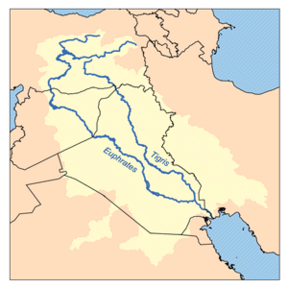
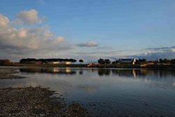
The river is approximately 2,780 km (1,700 miles) long. It is formed by the union of two branches, the Kara (the western Euphrates), which rises in the highlands of eastern Turkey north of Erzerum and the Murat (the eastern Euphrates), which issues from an area southwest of Mount Ararat, north of Lake Van. The upper reaches of the Euphrates flow through steep canyons and gorges then southeast across Syria and then through Iraq. The Khabur and the Balikh River join the Euphrates in eastern Syria.
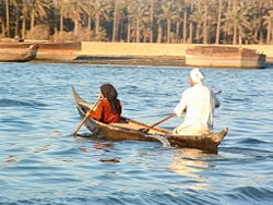
They both have their origins in Turkey. Downstream, through its whole length, the Euphrates receives no further water flow. North of Basra, in southern Iraq, the river merges with the Tigris to form the Shatt al-Arab, which in turn empties into the Persian Gulf.
The river used to divide into many channels at Basra, forming an extensive marshland, but the marshes were largely drained by the Saddam Hussein government in the 1990s as a means of driving out the rebellious Marsh Arabs. Since the 2003 invasion of Iraq, the drainage policy has been reversed, but it remains to be seen whether the marshes will recover. The Euphrates is only navigable by very shallow-draft boats, which can reach as far as the Iraqi city of Hit, located 1,200 miles upstream and which is only 53 meters above sea level. Above Hit, however, shoals and rapids make the river commercially unnavigable. Its annual inundation, caused by snowmelt in the mountains of north-eastern Turkey, has been partly checked by new dams and reservoirs in the upper reaches. A 550-mile canal links the Euphrates to the Tigris to serve as a route for river barges.
Euphrates in the Bible
The river Euphrates is one of the four rivers that flow from the Garden of Eden according to Book of Genesis 2:14. It is the fourth river, after Pishon, Gihon, and Tigris, to form from the river flowing out of the garden. The river also marked one of the boundaries of the land promised by God to Abraham and his descendants. In the Hebrew Bible it is often referred to simply as "The River" (ha-nahar).
In the Book of Revelation, it is prophesied that in the "end times" the river will dry up in preparation for the Battle of Armageddon.
In Islam, some of the hadiths of Muhammad suggest that the Euphrates will dry up, revealing unknown treasures that will be the cause of strife and war.
Euphrates in history
The Euphrates provided the water that led to the first flowering of civilisation in Sumeria, dating from about the 4th millennium B.C.E. Many important ancient cities were located on or near the riverside, including Mari, Sippar, Nippur, Shuruppak, Uruk, Ur and Eridu. The river valley formed the heartlands of the later empires of Babylonia and Assyria. For several centuries the river formed the eastern limit of effective Egyptian and Roman control and western regions of the Persian Empire.
Controversial issues
As with the Tigris there is much controversy over rights and use of the river. The Southeast Anatolia Development Project in Turkey involves the construction of 22 dams and 19 power plants by 2005, the biggest development project ever undertaken by Turkey. The first of the dams was completed in 1990. Southeast Turkey is still struggling economically, adding fuel to the discontent expressed by Turkey's Kurdish minority centered there. The Turkish authorities hope that the project will provide a boost to the region's economy, but domestic and foreign critics have disputed its benefits as well as attacking the social and environmental costs of the scheme.
In Syria the Tabqa Dam (completed in 1973 and sometimes known simply as the Euphrates Dam) forms a reservoir, Lake Assad, that is used for irrigating cotton. Syria has dammed its two tributaries and is constructing another dam. Iraq has seven dams in operation, but water control lost priority during Saddam Hussein's regime. Since the collapse of Ba'ath Iraq in 2003, water use has come once again to the fore. The scarcity of water in the Middle East leaves Iraq in constant fear that Syria and Turkey will use up most of the water before it reaches Iraq. As it is, irrigation in southern Iraq leaves little water to join the Tigris at the Shatt-al-Arab.
External links
- Jewish Encyclopedia: Euphrates; discusses the Old Testament references to the river
- Tigris-Euphrates River dispute, details of conflict and cooperation
- Turkish presentation of the Euphrates project
Credits
New World Encyclopedia writers and editors rewrote and completed the Wikipedia article in accordance with New World Encyclopedia standards. This article abides by terms of the Creative Commons CC-by-sa 3.0 License (CC-by-sa), which may be used and disseminated with proper attribution. Credit is due under the terms of this license that can reference both the New World Encyclopedia contributors and the selfless volunteer contributors of the Wikimedia Foundation. To cite this article click here for a list of acceptable citing formats.The history of earlier contributions by wikipedians is accessible to researchers here:
The history of this article since it was imported to New World Encyclopedia:
Note: Some restrictions may apply to use of individual images which are separately licensed.


