Colombo
| Colombo | |||
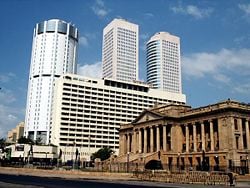
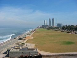
| The skyline of the Fort area. The twin towers of the World Trade Center building are in the background, with the Bank of Ceylon tower to their left and the Presidential Secretariat in the foreground. | |||
|
|||
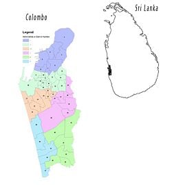
| Map of Colombo showing its administrative districts. | |||
| Map of Colombo showing its administrative districts. | |||
| Coordinates: {{#invoke:Coordinates|coord}}{{#coordinates:6|54|0|N|79|50|0|E|type:city | |||
|---|---|---|---|
| name= }} | |||
| District | Colombo District | ||
| Government | |||
| - Mayor | Uvais Mohamed Imitiyas (Independent) | ||
| - Deputy Mayor | S. Rajendran (Independent Group) | ||
| Area | |||
| - City | 37.31 km² (14.4 sq mi) | ||
| Population (2001[1]) | |||
| - City | 642,163 | ||
| - Density | 17,211/km² (44,576.3/sq mi) | ||
| - Metro | 2,234,000 | ||
| Time zone | Sri Lanka Standard Time Zone (UTC+5:30) | ||
| - Summer (DST) | Summer time (UTC+6) | ||
| Website: www.cmc.lk | |||
Colombo (Sinhala: ![]() , pronounced [ˈkoləmbə]; Tamil: கொழும்பு) is the largest city and commercial capital of Sri Lanka. Located on the west coast of the island and adjacent to Sri Jayawardenepura Kotte, the administrative capital of Sri Lanka, Colombo is a busy and vibrant city with a mixture of modern life and colonial buildings and ruins.
, pronounced [ˈkoləmbə]; Tamil: கொழும்பு) is the largest city and commercial capital of Sri Lanka. Located on the west coast of the island and adjacent to Sri Jayawardenepura Kotte, the administrative capital of Sri Lanka, Colombo is a busy and vibrant city with a mixture of modern life and colonial buildings and ruins.
Due to its large harbour and its strategic position along the East-West sea trade routes, Colombo was known to ancient traders 2000 years ago. However it was only made the capital of the island when Sri Lanka was ceded to the British Empire in 1815,[2] and its status as capital was retained when the nation became independent in 1948. In 1978, when administrative functions were moved to Sri Jayawardenepura Kotte, Colombo was designated as the commercial capital of Sri Lanka.
The main city is home to a majority of the Sri Lanka's corporate offices, restaurants and entertainment venues.[3] Famous landmarks in Colombo include the Galle Face Green, the Viharamahadevi Park as well as the National Museum.
Geography
The name "Colombo", first introduced by the Portuguese in 1505, is believed to be derived from the classical Sinhalese name Kolon thota, meaning "port on the river Kelani".[4] It has also been suggested that the name may be derived from the Sinhalese name Kola-amba-thota which means "Harbor with leafy mango trees".[3][5]
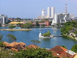
Colombo's geography is a mix of land and water. The city has many canals and, in the heart of the city, the 65 hectare Beira Lake.[6] The lake is one of the most distinctive landmarks of Colombo, and was used for centuries by colonists to defend the city.[6] It remains a popular attraction, hosting regattas,[7] and theatrical events on its shores. The Northern and North-Eastern border of the city of Colombo is formed by the Kelani River, which meets the sea in a part of the city known as the Modera (mōdara in Sinhala) which means river delta.
Colombo’s climate is fairly temperate all throughout the year. From March to April the temperature averages around 88°F (31°C) maximum. Colombo sees little relative diurnal range of temperature, although this is more marked in the drier winter months, where minimum temperatures average 72°F (22°C). The only change occurs during the monsoon seasons from May to August, and October to January, when heavy rains can be expected. Mean annual precipitation is 94 inches (2400mm).
Environmental issues include coastal degradation from increased pollution, freshwater resources being polluted by industrial wastes and sewage runoff, inadequate waste disposal, and air pollution.
The fort, the fortifications of which are long gone, and the area outside the fort, the Pettah, are the oldest districts. The fort is the the city's nerve center of government and commercial activity. The Pettah has small shops, markets, and sidewalk stalls. Main St consists mostly of clothes shops while each of the cross streets, specializes in a specific business, such as[electronics]]s, cellular phones, and fancy goods. The mile-long Sea St is Sri Lanka's gold market, and is full of jewellery shops. Cinnamon Gardens, south of Beira Lake, was where the Dutch grew cinnamon.
History
Paleolithic human settlements have been discovered at excavations in several cave sites in the Western Plains region and the South-western face of the Central Hills region. The recorded History of Sri Lanka is usually taken to begin in the sixth century B.C.E., when the Indo-Aryan people, who are known as the Sinhalese, migrated into the island from India. As Colombo possesses a natural harbour, it was known to Romans, Arabs, and Chinese traders over 2000 years ago. Traveller Ibn Batuta who visited the island in the 14th century, referred to it as Kalanpu.
Arabian Muslims whose prime interests were trade, began to settle in Colombo around the 8th century CE mostly because the port helped their business and controlled much of the trade between the Sinhalese kingdoms and the outside world. They now comprise the local Sri Lankan Moor community.
Portuguese arrive
The first Europeans to visit Sri Lanka in modern times were the Portuguese: Francisco de Almeida arrived in 1505, finding the island divided into seven warring kingdoms and unable to fend off intruders. The Portuguese founded a fort at the Muslim port city of Colombo in 1517 and gradually extended their control over the coastal areas. In 1592, the Sinhalese moved their capital to the inland city of Kandy, a location more secure against attack from invaders. Intermittent warfare continued through the sixteenth century.
In 1638, the Dutch signed a treaty with King Rajasinha II of Kandy to help in his war against the Portuguese in exchange for a monopoly of the island's trade. Although at that time, much of the island came under the domain of European powers, the interior, hilly region of the island remained independent, with its capital in Kandy. By 1660 the Dutch controlled the whole island except the kingdom of Kandy. A mixed Dutch-Sinhalese people known as Burgher peoples are a legacy of Dutch rule.
British capture Colombo
Although the British captured Colombo in 1796, it remained a British military outpost until the Kandyan Kingdom was ceded to them in 1815 and they made Colombo the capital of the newly created crown colony of Ceylon. Unlike the Portuguese and Dutch before them, whose primary use of Colombo was as a military fort, the British began constructing houses and other civilian structures around the fort, giving rise to the City of Colombo.
European colonists established a series of tea, cinnamon, rubber, sugar, coffee and indigo plantations. The British also brought a large number of indentured workers from Tamil Nadu to work in the plantation economy. The city of Colombo was established as the administrative center, and the British established modern schools, colleges, roads and churches that brought Western-style education and culture to the native people. English was established as the main language for governance, until after independence. John Macdowell of the Madras Service was the first to hold the office of "collector", to administer Colombo. Then, in 1833, the Government Agent of the Western Province was charged with the administration of the city.
Centuries of colonial rule had meant a decline of indigenous administration of Colombo, and in 1865 the British conceived a Municipal Council as a means of training the local population in self-governance. The Legislative Council of Ceylon constituted the Colombo Municipal Council in 1865 and the Council met for the first time on the January 16, 1866. At the time, the population of the region was around 80,000.
The British were responsible for much of the planning of the present city. In some parts of the city tram car tracks, and granite flooring laid during the era, remain visible.
Assembly partly elected
It was not until 1909 that constitutional development began with a partly-elected assembly, and not until 1920 that elected members outnumbered official appointees. Universal suffrage was introduced in 1931, over the protests of the Sinhalese, Tamil and Burgher elite who objected to the common people being allowed to vote.
The nation of Sri Lanka lived in conflict throughout the twentieth century, seeking independence and self-rule. In 1919 the Ceylon National Congress (CNC) was founded to agitate for greater autonomy. Increasing grievances over the denial of civil rights and mistreatment and abuse of natives by colonial authorities gave rise to the Sri Lanka Independence Struggle in the 1930s. The Marxist Lanka Sama Samaja Party (LSSP), grew out of the Youth Leagues in 1935, and was the first party to demand independence. They also demanded the replacement of English as the official language by Sinhala and Tamil.
Second World War
During World War II, the island served as an important front-line British base against the Japanese. A large segment of the British and American fleet were deployed on the island, as were tens of thousands of soldiers committed to the war against Japan in Southeast Asia.
There was considerable opposition to the war in Sri Lanka, and the LSSP leaders of the pro-independence agitation were arrested by the Colonial authorities. On April 5, 1942, The Japanese Navy bombed Colombo and LSSP leaders were able to escape. Several of them fled to India, where they participated in the struggle there, but a sizeable contingent remained, led by Robert Gunawardena.
Independence
Following the war, popular pressure for independence intensified. On February 4, 1948 the country won its independence as the Commonwealth of Ceylon. Don Stephen Senanayake became the first Prime Minister of Sri Lanka. He died in 1952 and was succeeded first by his son Dudley Senanayake and in 1953 - following a massive general strike by the Left parties against the UNP government which led to Dudley Senanayake's resignation - by a relative, John Kotelawala. In 1957, British bases were removed and Sri Lanka officially became a non-aligned country.
Dissatisfaction with the economic situation brought the UNP under Senanayake back to office in 1965, but this government fared no better, since the underlying cause of Sri Lanka's problems was the declining market for its traditional commodity exports, tea, coffee and rubber. In 1968, Bandaranaike formed a coalition, the Sri Lanka United Front with the LSSP and the Communist Party of Sri Lanka, which swept the 1970 polls on a platform of socialism.
In 1972, the country became a republic within the Commonwealth, and the name was changed to Sri Lanka. On July 21, 1960, Sirimavo Bandaranaike became the first female head of government in post-colonial Asia when she took office as prime minister.
Political conflict
In the 1970s, political conflicts emerged between the Sinhalese and Tamil communities. The Tamil community sought increased regional autonomy and affirmative action. In 1971, the People's Liberation Front (JVP) launched an unsuccessful rebellion, considered to be motivated largely by anti-Tamil nationalism. The JVP established itself as a voice of extreme Sinhalese chauvinism.
In the 1980s, the Liberation Tigers of Tamil Eelam (LTTE) demanded an independent state of Ealam in north-eastern Sri Lanka. A 1986 peace accord brokered by India failed by 1988 when Indian peacekeepers were drawn into a direct military conflict with the LTTE while attempting to disarm the militants. Sri Lankan nationalists sought the exit of Indian troops, and by the year 2000 as many as 50,000 people were killed in battles between the Sri Lankan Army and the LTTE, which controls parts of the northeast. A tentative ceasefire has restored peace to the island as the government and the LTTE engage in diplomacy under the mediation of Norway.
Government
Sri Lanka is described as a democratic socialist republic in which the president, who is both the chief of state and head of government, is elected by popular vote for a six-year term. The cabinet is appointed by the president in consultation with the prime minister. The unicameral parliament consists of 225 members elected by popular vote on the basis of an open-list, proportional representation system by electoral district to serve six-year terms. For administrative purposes, the nation is divided into eight provinces.
The Colombo Metropolitan Region (CMR) encompasses the country's administrative capital Kotte and Colombo, which has a mayor-council form of government with elections held once in five years. The city government provides sewer, road management and waste management services, in case of water, electricity and telephone utility services the council liaises with the water supply and drainage board, the Ceylon electricity board and telephone service providers.
The Sri Lanka Police, the main law enforcement agency of the island, liaise with the municipal council, but is under the control of the Ministry of Defence of the central government. Policing in Colombo and its suburbs falls within the Metropolitan Range headed by the Deputy Inspector General of Police (Metropolitan), this also includes the Colombo Crime Division.
Colombo was the capital of the coastal areas controlled by the Portuguese, Dutch and the British from the 1700s to the 1815 when the British gained control of the entire island following the Kandian convention. Since then till the 1980s the national capital of the island was Colombo. During the 1980s plans were made to move the administrative capital to Sri Jayawardanapura Kotte and thus move all governmental institutions out of Colombo to make way for commercial activities. As a primary setp the Parliament was moved to a new complex in Kotte and several ministries and departments were also moved. However the move was never completed. Today many, governmental institutions still remain in Colombo.
Economy
The Sri Lanka government abandoned statist economic policies and its import substitution trade policy, in 1977, for more market-oriented policies, export-oriented trade, and encouragement of foreign investment. Recent changes in government, however, have brought some policy reversals. Currently, the ruling Sri Lanka Freedom Party has a more statist economic approach, which seeks to reduce poverty by steering investment to disadvantaged areas, developing small and medium enterprises, promoting agriculture, and expanding the already enormous civil service.
Sri Lanka's most dynamic sectors now are food processing, textiles and apparel, food and beverages, port construction, telecommunications, and insurance and banking.
Colombo is the commercial centre of Sri Lanka. The head offices of banks, the state monopoly Insurance Corporation, brokerage houses, and government corporations are located there.
High land prices have contributed to a building boom of high rise condominiums. South Asia's second tallest building, the 40-story Twin Tower World Trade Center is situated in the Fort district.
Almost all major media businesses in Sri Lanka operate from Colombo. Sri Lanka per capita GDP was estimated at $US4100 in 2007.
Colombo's manufacturing focuses on processing of raw materials for export. Industries include chemicals, textiles, glass, cement, leather goods, furniture, and jewelry.
Colombo has an extensive public transport system based on buses. The Central Bus Stand and Fort Railway Station functions as the island's primary hub for bus and rail transport respectively. Up until the 1970s the city had a trams service, which was discontinued. Other means of transport includes auto rickshaws (commonly called "three wheelers") and taxicabs. Construction of the Colombo Metro Rail, a Mass Rapid Transit railway system, similar to that of other advanced Asian cities, had begun by 2008.
Bandaranaike International Airport serves the city for all International flights while the Ratmalana Airport serves all local flights.
The Colombo port, which dates back to the 14th century, was expanded after 1948 with the construction of the Queen Elizabeth Quay together with the completion of 16 alongside berths, transit sheds, and warehouses. It was modernized in the 1980s, with cranes, gantries, and other container terminal equipment, and the access channel was deepened in the 1990s. The port of Colombo was rated as one of the top 35 ports in the world by 2008.
Demographics
Colombo is the most populated city in Sri Lanka, with 642,163 people living within the city limits.
Colombo is a multi-ethnic, multi-cultural city. The population of Colombo is a mix of numerous ethnic groups, mainly Sinhalese 41.36 percent, Moors 23.87 percent, and Tamils 28.91 percent. There are also small communities of people with Chinese, Portuguese, Dutch, Malay (1.73 percent) and Indian Tamil (2.17 percent) origins living in the city, as well as numerous European expatriates.
Sinhala and Tamil are the two official languages of Sri Lanka. English is spoken by approximately 10 percent of the population, and is widely used for education, scientific and commercial purposes. Members of the Burgher community speak variant forms of Portuguese Creole and Dutch.
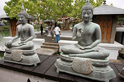
Approximately 68 percent of Sri Lankan peoples are adherents of Buddhism. Theravada Buddhism is the predominant school. Hinduism is practiced by 18 percent of the population, mainly from the Tamil community, Christianity is practiced by up to eight percent, especially by the Portuguese and Dutch Burgher people. While most Sri Lankan Christians are Catholics, there are also significant numbers who adhere to Dutch Reformed Church and the Anglican Communion.
The Colombo Medical School and the Colombo Law College were established in the 1870s. The Ceylon University College was established in 1913, followed by the formation of the University of Ceylon, which had a campus in Colombo. Today the University of Colombo and the University of the Visual & Performing Arts are state universities in the city. The Sri Lanka Institute of Information Technology also has a metropolitan campus in the center of the city. There are several private higher education institutions within the city.
Of interest
This image is a candidate for speedy deletion. It will be deleted after seven days from the date of nomination.
Notes
- ↑ Census July 17, 2001 (via citypopulation.de)
- ↑ History of Colombo. Retrieved 2007-03-21.
- ↑ 3.0 3.1 World Executive Colombo Hotels and City Guide
- ↑ "Colombo - then and now", Padma Edirisinghe, The Sunday Observer, 14 February, 2004.
- ↑ Jayewardene, Mr.. How Colombo Derived its Name. Retrieved 2007-01-18.
- ↑ 6.0 6.1 The lake in the middle of Colombo, Lanka Library
- ↑ 35th boat race and 31st Regatta: Oarsmen of Royal and S. Thomas' clash on Beira waters, Daily News, October 10, 2003
Further reading
- Brohier, Richard Leslie, and Ismeth Raheem. 1984. Changing face of Colombo, 1505-1972: covering the Portuguese, Dutch, and British periods. Colombo: Lake House Investments. OCLC 12345141
- Dharmasena, K. 1980. The port of Colombo, 1860-1939. Colombo: Ministry of Higher Education (Sri Lanka). OCLC 59683734
- Perera, Nihal. 1999. Decolonizing Ceylon: colonialism, nationalism, and the politics of space in Sri Lanka. New Delhi: Oxford University Press. ISBN 9780195646436
External links
- Encyclopaedia Britannica Colombo Retrieved August 26, 2008.
- World Fact Book 2008 Sri Lanka Retrieved August 26, 2008.
- Port of Colombo Retrieved August 26, 2008.
- Tourism within Colombo city Retrieved August 26, 2008.
- Lanka Media Talk Retrieved August 26, 2008.
- Searchable map of Colombo and Sri Lanka Retrieved August 26, 2008.
- Historic photographs of Sri Lanka Retrieved August 26, 2008.
Credits
New World Encyclopedia writers and editors rewrote and completed the Wikipedia article in accordance with New World Encyclopedia standards. This article abides by terms of the Creative Commons CC-by-sa 3.0 License (CC-by-sa), which may be used and disseminated with proper attribution. Credit is due under the terms of this license that can reference both the New World Encyclopedia contributors and the selfless volunteer contributors of the Wikimedia Foundation. To cite this article click here for a list of acceptable citing formats.The history of earlier contributions by wikipedians is accessible to researchers here:
The history of this article since it was imported to New World Encyclopedia:
Note: Some restrictions may apply to use of individual images which are separately licensed.
