Difference between revisions of "Antananarivo" - New World Encyclopedia
Mike Butler (talk | contribs) |
Mike Butler (talk | contribs) |
||
| Line 69: | Line 69: | ||
==Geography== | ==Geography== | ||
| − | Antananarivo, | + | Antananarivo, which is Madagascar's largest [[city]] and is its [[Administration (government)|administrative]], [[communication]]s, and [[economic]] center, is situated in the center of the [[island]] length-wise, and 90 miles (145km) away from the eastern coast. |
| − | + | The city occupies a commanding position, being built on the [[summit]] and [[slopes]] of a long and narrow [[Rock (geology)|rock]]y [[ridge]], which extends north and south for about {{convert|2|mi|km|0|abbr=on}} and rising at its highest point to about {{convert|660|ft|m|-1|abbr=on}} above the extensive rice plain to the west, although the town is at about 4183 feet (1275 meters) above sea level. | |
There are two seasons: It is hot and rainy from November to April, with temperatures of 70°F (21°C) in January, and cooler and dry from May to October, 58°F (14°C) in July. | There are two seasons: It is hot and rainy from November to April, with temperatures of 70°F (21°C) in January, and cooler and dry from May to October, 58°F (14°C) in July. | ||
| − | + | The [[Ikopa River]] skirts the capital to the south and west. | |
| + | |||
Size – land area, size comparison | Size – land area, size comparison | ||
Environmental issues | Environmental issues | ||
Districts | Districts | ||
| − | + | The city is located 134 miles (215km) west-southwest of [[Toamasina]], the principal [[seaport]] of the island, with which it is connected by [[railway]], and for about 62 miles (100km) along the coastal [[lagoon]]s, a service of small steamers. | |
==History== | ==History== | ||
[[Image:Antananarivo Four Roads c1905.jpg|left|thumb|230px|A theater in Antananarivo around 1905]] | [[Image:Antananarivo Four Roads c1905.jpg|left|thumb|230px|A theater in Antananarivo around 1905]] | ||
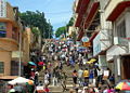
| − | Unlike most capital cities in [[southern Africa]], Antananarivo was already a major city before the colonial era. The city was founded circa | + | [[Image:Antananarivo Street.JPG|thumb|right|250px|A busy street in Antananarivo]] |
| + | |||
| + | Unlike most capital cities in [[southern Africa]], Antananarivo was already a major city before the colonial era. The city was founded circa 1625 by King Andrianjaka and takes its name (the City of the Thousand) from the number of soldiers assigned to guarding it. For many years it was the principal [[village]] of the Hova [[Tribal chief|chiefs]] and gained importance as those chiefs made themselves [[Head of State|sovereigns]] of the greater part of [[Madagascar]], eventually becoming a [[town]] of some 80,000 inhabitants. | ||
| + | |||
| + | In 1793, it was made the [[capital]] of the [[Merina]] [[Monarch|king]]s. The conquests of King [[Radama I]] made Antananarivo the capital of almost all of [[Madagascar]]. | ||
| + | |||
| + | The city was captured by the [[France|French]] in [[1895]] and incorporated into their Madagascar [[protectorate]]. After the [[History of Madagascar#French control|French conquest of Madagascar]] when the city had a population of some 100,000, it was extensively remodeled as the population grew to 175,000 by 1950. Roads were constructed throughout the city, broad flights of steps connecting places too steep for the formation of carriage roads, and the central space, called Andohalo, was enhanced with walks, terraces, flower-beds and trees. Water, previously obtained from springs at the foot of the hill, was brought from the [[Ikopa River]], which skirts the capital. | ||
| + | |||
| + | After independence in 1960 the pace of growth increased rapidly. The city's population reached 1.4 million by the end of the twentieth century. [[Industries]] include [[food|food products]], [[cigarette]]s, and [[textiles]]. | ||
| + | |||
| + | The city is guarded by two forts built on hills to the east and south-west. Including an Anglican and a Roman Catholic cathedral, there are about fifty churches in the city and its suburbs, as well as a [[Muslim]] [[mosque]]. Antananarivo hosts a campus of the [[University of Madagascar]] and the Collège Rural d'Ambatobe. | ||
| + | |||
| + | Until 1869, all buildings within the [[city]] proper were of [[wood]] or [[Juncus|rushes]], but even then it possessed several timber [[palace]]s of considerable size, the largest being {{convert|120|ft|m|0|abbr=on}} high. These crown the summit of the central portion of the ridge; and the largest palace, with its lofty [[roof]] and [[tower]]s, is the most conspicuous object from every point of view. | ||
Since the introduction of stone and [[brick]], the entire city has been rebuilt and now contains numerous European-style structures, including the royal palaces, the houses formerly belonging to the [[prime minister]] and [[nobles]], the [[French people|French]] [[Residency (domicile)|residency]], the [[Anglican]] and [[Roman Catholic]] [[cathedrals]], and several stone [[churches]]. | Since the introduction of stone and [[brick]], the entire city has been rebuilt and now contains numerous European-style structures, including the royal palaces, the houses formerly belonging to the [[prime minister]] and [[nobles]], the [[French people|French]] [[Residency (domicile)|residency]], the [[Anglican]] and [[Roman Catholic]] [[cathedrals]], and several stone [[churches]]. | ||
{{clr}} | {{clr}} | ||
| − | == | + | ==Economy== |
| − | + | Overview – Any specialization: For instance, is a manufactured product is associated with particular cities | |
| − | + | a. Milwaukee—cheese and beer | |
| + | b. Los Angeles—entertainment industry | ||
| + | c. Sheffield—coal | ||
| + | d. top 20 cities in the U.S. are highly specialized | ||
| + | |||
| + | Per capita GDP, rank | ||
| + | Financial and business services sector | ||
| + | Tourism | ||
| + | Manufacturing | ||
| + | Transport: Road, rail, air, sea | ||
| + | |||
| − | |||
| − | |||
{{clr}} | {{clr}} | ||
Revision as of 23:29, 2 July 2008
| Antananarivo Tananarive |
|||
 |
|||
|
|||
| Nickname: Tana | |||
 |
|||
| Country | Madagascar | ||
|---|---|---|---|
| Founded | 1625 | ||
| Elevation | 1,276 m (4,186 ft) | ||
| Population (2001 census) | |||
| - Total | 1,403,449 | ||
| Time zone | East African Time (GMT+3) (UTC) | ||
Antananarivo (pronounced /ˌtəˌnænəˈriːv/ or /ˌtəˌnɑːnəˈriːv/) is the capital and largest city in Madagascar. It is also known by its French name Tananarive or the colonial shorthand form Tana.
The larger urban area surrounding the city, known as Antananarivo-Renivohitra ("Antananarivo-Capital"), is the capital of the Analamanga region and of the Antananarivo autonomous province.
Geography
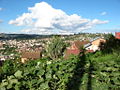
Antananarivo, which is Madagascar's largest city and is its administrative, communications, and economic center, is situated in the center of the island length-wise, and 90 miles (145km) away from the eastern coast.
The city occupies a commanding position, being built on the summit and slopes of a long and narrow rocky ridge, which extends north and south for about 2 mi (3 km) and rising at its highest point to about 660 ft (200 m) above the extensive rice plain to the west, although the town is at about 4183 feet (1275 meters) above sea level.
There are two seasons: It is hot and rainy from November to April, with temperatures of 70°F (21°C) in January, and cooler and dry from May to October, 58°F (14°C) in July.
The Ikopa River skirts the capital to the south and west.
Size – land area, size comparison Environmental issues Districts
The city is located 134 miles (215km) west-southwest of Toamasina, the principal seaport of the island, with which it is connected by railway, and for about 62 miles (100km) along the coastal lagoons, a service of small steamers.
History


Unlike most capital cities in southern Africa, Antananarivo was already a major city before the colonial era. The city was founded circa 1625 by King Andrianjaka and takes its name (the City of the Thousand) from the number of soldiers assigned to guarding it. For many years it was the principal village of the Hova chiefs and gained importance as those chiefs made themselves sovereigns of the greater part of Madagascar, eventually becoming a town of some 80,000 inhabitants.
In 1793, it was made the capital of the Merina kings. The conquests of King Radama I made Antananarivo the capital of almost all of Madagascar.
The city was captured by the French in 1895 and incorporated into their Madagascar protectorate. After the French conquest of Madagascar when the city had a population of some 100,000, it was extensively remodeled as the population grew to 175,000 by 1950. Roads were constructed throughout the city, broad flights of steps connecting places too steep for the formation of carriage roads, and the central space, called Andohalo, was enhanced with walks, terraces, flower-beds and trees. Water, previously obtained from springs at the foot of the hill, was brought from the Ikopa River, which skirts the capital.
After independence in 1960 the pace of growth increased rapidly. The city's population reached 1.4 million by the end of the twentieth century. Industries include food products, cigarettes, and textiles.
The city is guarded by two forts built on hills to the east and south-west. Including an Anglican and a Roman Catholic cathedral, there are about fifty churches in the city and its suburbs, as well as a Muslim mosque. Antananarivo hosts a campus of the University of Madagascar and the Collège Rural d'Ambatobe.
Until 1869, all buildings within the city proper were of wood or rushes, but even then it possessed several timber palaces of considerable size, the largest being 120 ft (37 m) high. These crown the summit of the central portion of the ridge; and the largest palace, with its lofty roof and towers, is the most conspicuous object from every point of view.
Since the introduction of stone and brick, the entire city has been rebuilt and now contains numerous European-style structures, including the royal palaces, the houses formerly belonging to the prime minister and nobles, the French residency, the Anglican and Roman Catholic cathedrals, and several stone churches.
Economy
Overview – Any specialization: For instance, is a manufactured product is associated with particular cities
          a.  Milwaukee—cheese and beer
          b.  Los Angeles—entertainment industry
          c.  Sheffield—coal
          d.  top 20 cities in the U.S. are highly specialized
Per capita GDP, rank Financial and business services sector Tourism Manufacturing Transport: Road, rail, air, sea
Sister cities
ReferencesISBN links support NWE through referral fees
- This article incorporates text from the Encyclopædia Britannica Eleventh Edition, a publication now in the public domain.
Gallery
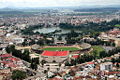
Anosy lake
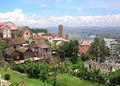
The upper city
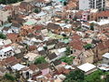
Houses
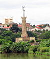
Monument to the soldiers who died for France
Antananarivo
Staircases leading to the Independence square
Independence avenue
Independence avenue


.jpg)


External links
- Antananarivo Renivohitra Official website.
- Antananarivo, The City Of A Thousand Warriors escapeartist.com, retrieved July 1, 2008.
Template:Antananarivo