Nanda Devi National Park
| Nanda Devi and Valley of Flowers National Parks* | |
|---|---|
| UNESCO World Heritage Site | |

| |
| State Party | |
| Type | Natural |
| Criteria | vii, x |
| Reference | 335 |
| Region** | Asia-Pacific |
| Inscription history | |
| Inscription | 1988 (12th Session) |
| Extensions | 2005 |
| * Name as inscribed on World Heritage List. ** Region as classified by UNESCO. | |
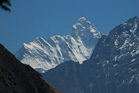
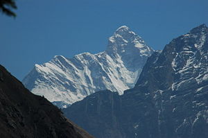
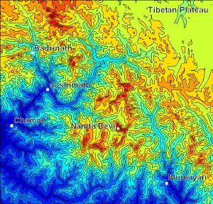
The Nanda Devi National Park is a national park situated around the peak of Nanda Devi, 7,817 m (25,646 ft), in the state of Uttarakhand in northern India. It was established as national park in 1982 and was inscribed a World Heritage Site by UNESCO in 1988[1]. It covers 630.33 km²[2].
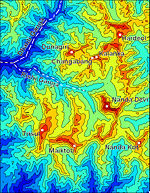
The park encompasses the Nanda Devi Sanctuary, a glacial basin surrounded by a ring of peaks between 6,000 m (19,700 ft) and 7,500 m (24,600 ft) high, and drained by the Rishi Ganga through the Rishi Ganga Gorge, a steep, almost impassable defile. Together with the nearby Valley of Flowers National Park to the northwest, it is a designated World Heritage Site. Both parks are encompassed in the Nanda Devi Biosphere Reserve (223,674 ha) which is further surrounded by a buffer zone (5,148.57 km²).[2]
The entire park lies at an elevation of more than 3,500 m (11,500 ft) above mean sea level.
Layout of the Sanctuary
The Sanctuary can be divided into two parts, Inner and Outer. Together, they are surrounded by the main Sanctuary Wall, which forms a roughly square outline, with high, continuous ridges on the north, east, and south sides. On the west side, less high but still imposing ridges drop from the north and south toward the Rishi Ganga Gorge, which drains the Sanctuary towards the west.[3]
The Inner Sanctuary occupies roughly the eastern two-thirds of the total area, and contains Nanda Devi itself and the two major glaciers flanking the peak, the Uttari (north) Rishi Glacier and the Dakkhni (south) Rishi Glacier. These are fed by the smaller Uttari Nanda Devi and Dakkhni Nanda Devi Glaciers respectively.[3] The first recorded entry of humans into the Inner Sanctuary was by Eric Shipton and H. W. Tilman in 1934, via the Rishi Gorge.[4]
The Outer Sanctuary occupies the western third of the total Sanctuary, and is separated from the Inner Sanctuary by high ridges, through which flows the Rishi Ganga. It is split in two by the Rishi Ganga; on the north side lies the Ramani Glacier, flowing down from the slopes of Dunagiri and Changabang, and on the south lies the Trisul Glacier, flowing from the peak of the same name. This portion of the Sanctuary is accessible to the outside (though requiring the crossing of a 4,000 m (13,000 ft) pass). The first serious climbing expedition to pass through the Outer Sanctuary was that of T. G. Longstaff, who climbed Trisul I in 1907 via the eponymous glacier.[4]
The Rishi Gorge
| Nanda Devi National Park | |
|---|---|
| IUCN Category Ia (Strict Nature Reserve) | |
| Location: | Uttarakhand, India |
| Area: | 630.33 km² |
| Established: | 1982 |
The Rishi Ganga begins in the Inner Sanctuary, near the confluence of the two Rishi Glaciers. It then flows through the Rishi Gorge, which has two separate sections. The Upper Gorge, about 3 km (2 mi) long, forms the connection between the Inner and Outer Sanctuaries, and is the crux of the route forged by Shipton and Tilman into the Sanctuary. From the peak of Rishi Kot, just to the north of the Upper Gorge, to the river is a 2,500 m (8,200 ft) vertical drop, giving a sense of the scale and steepness of the terrain. The going through this section involves a good deal of travel on sloping rock slabs and steep, sparsely vegetated slopes, often with great exposure.[4]
After passing through the Upper Gorge the valley widens out somewhat and the slopes become less precipitous on either side, for about 4 km (2 mi). The Shipton-Tilman route crosses the river here over a natural bridge formed by a huge boulder, and ascends the north side of the canyon to bypass the Lower Gorge, into which the Rishi now descends. The Lower Gorge, about 4 km (2 mi) long, is even steeper than the Upper, and in 1934, even though it had been circumvented by local shepherds, it had not been traversed directly.[4]
Named peaks of the Park and environs
Within the Sanctuary
Apart from Nanda Devi, the following peaks lie on ridges dividing the Inner and Outer Sanctuary areas.
- Nanda Devi: 7,816 m (25,643 ft)
- Devistan I, II: 6,678 m (21,909 ft), 6,529 m (21,421 ft)
- Rishi Kot: 6,236 m (20,459 ft)
On the Sanctuary Wall
These peaks are listed in clockwise order, starting from just north of the Rishi Gorge. Some of them are relatively minor summits and have small topographic prominence, while others are independent peaks.
- Hanuman: 6,075 m (19,931 ft)
- Dunagiri: 7,066 m (23,182 ft)
- Changabang: 6,864 m (22,520 ft)
- Kalanka: 6,931 m (22,740 ft)
- Rishi Pahar: 6,992 m (22,940 ft)
- Mangraon: 6,568 m (21,549 ft)
- Deo Damla: 6,620 m (21,719 ft)
- Bamchu: 6,303 m (20,679 ft)
- Sakram: 6,254 m (20,518 ft)
- Latu Dhura: 6,392 m (20,971 ft)
- Nanda Devi East: 7,434 m (24,390 ft)
- Nanda Khat: 6,611 m (21,690 ft)
- Panwali Doar (or "Panwali Dwar"): 6,663 m (21,860 ft)
- Maiktoli: 6,803 m (22,320 ft)
- Mrigthuni: 6,855 m (22,490 ft)
- Trisul I, II, III: 7,120 m (23,360 ft), 6,690 m (21,949 ft), 6,008 m (19,711 ft)
- Bethartoli Himal: 6,352 m (20,840 ft)
Just outside the Wall
The following are the most notable peaks which are adjacent to the wall; they are all connected to the Wall by high passes. They lie just outside the boundaries of the Park.
- Hardeol: 7,151 m (23,461 ft) (northeast corner)
- Trishuli: 7,074 m (23,209 ft) (just beyond Hardeol)
- Nanda Kot: 6,861 m (22,510 ft) (southeast corner)
- Nanda Ghunti: 6,309 m (20,699 ft) (southwest corner)
Nanda Devi
| Nanda Devi | |||
|---|---|---|---|
 | |||
| Elevation | 7,816 m (25,643 ft) Ranked 23rd | ||
| Location | Uttarakhand, India | ||
| Mountain range | Garhwal Himalaya | ||
| Prominence | 3,139 m (10,298.5564461 ft)[5]Ranked 74th | ||
| Geographic coordinates | {{#invoke:Coordinates|coord}}{{#coordinates:30|22|36|N|79|58|15|E|type:mountain | name= | |
| First ascent | August 29, 1936 by Noel Odell and Bill Tilman[7][8] | ||
| Easiest Climbing route | south ridge: technical rock/snow/ice climb | ||
Nanda Devi is the second highest mountain in India, and the highest entirely within the country. (Kangchenjunga, on the border of India and Nepal, is the highest peak in India. However, as per the Indian Government, K2 is the highest mountain in India). It is part of the Garhwal Himalaya, and is located in the state of Uttarakhand, between the Rishiganga valley on the west and the Goriganga valley on the east. Its name means Bliss-Giving Goddess. The peak is regarded as the patron-goddess of the Uttarakhand Himalaya.
Description and notable features
Nanda Devi is a two-peaked massif, forming a 2 km (1.2 mi) long high ridge, oriented east-west. The west summit is higher, and the eastern summit is called Nanda Devi East. Together the peaks are referred to as the twin peaks of the goddess Nanda. The main summit stands guarded by a barrier ring comprising some of the highest mountains in the Indian Himalayas (one of which is Nanda Devi East), twelve of which exceed 6,400 m (21,000 ft) in height, further elevating its sacred status as the daughter of the Himalaya in local myth and folklore. The interior of this almost insurmountable ring is known as the Nanda Devi Sanctuary, and is protected as the Nanda Devi National Park. Nanda Devi East lies on the eastern edge of the ring (and of the Park), at the border of Chamoli, Pithoragarh and Bageshwar districts.
In addition to being the 23rd highest independent peak in the world, Nanda Devi is also notable for its large, steep rise above local terrain. It rises over 3,300 m (10,800 ft) above its immediate southwestern base on the Dakkhni Nanda Devi Glacier in about 4.2 km (2.6 mi), and its rise above the glaciers to the north is similar. This makes it among the steepest peaks in the world at this scale, closely comparable, for example, to the local profile of K2. Nanda Devi is also impressive when considering terrain that is a bit further away, as it is surrounded by relatively deep valleys. For example, it rises over 6,500 m (21,300 ft) above the valley of the Ghoriganga in only 50 km (30 mi).[3]
On the northern side of the massif lies the Uttari Nanda Devi Glacier, flowing into the Uttari Rishi Glacier. To the southwest, one finds the Dakkhni Nanda Devi Glacier, flowing into the Dakkhni Rishi Glacier. All of these glaciers are located within the Sanctuary, and drain west into the Rishiganga. To the east lies the Pachu Glacier, and to the southeast lie the Nandaghunti and Lawan Glaciers, feeding the Lawan Gad; all of these drain into the Milam Valley. To the south is the Pindari Glacier, draining into the Pindar River. Just to the south of Nanda Devi East, dividing the Lawan Gad drainage from the Dakkhni Nanda Devi Glacier, is Longstaff Col, 5,910 m (19,390 ft), one of the high passes that guard access to the Nanda Devi Sanctuary.[3] For a list of notable peaks of the Sanctuary and its environs, see Nanda Devi National Park.
Exploration and climbing history
Nanda Devi (main summit)
| Nanda Devi East | |
|---|---|
| 300px Nanda Devi Massif from Kausani | |
| Elevation | 7,434 m (24,390 ft) |
| Location | Pithoragarh-Chamoli,Bageshwar Uttarakhand, India |
| Mountain range | Kumaun Himalaya |
| Prominence | 260 m (850 ft)[9][3] |
| First ascent | 1939 by J. Klaner, J. Bujak, and D. Tsering (Sherpa).[7] |
| Easiest Climbing route | south ridge, from Lawan Gad via Longstaff Col: technical rock/snow/ice climb |
The ascent of Nanda Devi necessitated fifty years of arduous exploration in search of a passage into the Sanctuary. The outlet is the Rishi Gorge, a deep, narrow canyon which is very difficult to traverse safely, and is the biggest hindrance to entering the Sanctuary; any other route involves difficult passes, the lowest of which is 5,180 m (16,990 ft). In 1934, the British explorers Eric Shipton and H.W. Tilman, with three Sherpa companions, Angtharkay, Pasang, and Kusang, finally discovered a way through the Rishi Gorge into the Sanctuary.
When the mountain was later climbed in 1936 by a British-American expedition, it became the highest peak climbed by man until the 1950 ascent of Annapurna, 8,091 m (26,545 ft). (However higher non-summit elevations had already been reached by the British on Mount Everest in the 1920s.) It also involved steeper and more sustained terrain than had been previously attempted at such a high altitude.[8] The expedition climbed the south ridge, also known as the Coxcomb Ridge, which leads relatively directly to the main summit.[7] The summit pair were H.W. Tilman and Noel Odell; Charles Houston was to be in place of Tilman, but he contracted severe food poisoning. Noted mountaineer and mountain writer H. Adams Carter was also on the expedition, which was notable for its small scale and lightweight ethic: it included only seven climbers, and used no fixed ropes, nor any Sherpa support above 6,200 m (20,300 ft). Eric Shipton, who was not involved in the climb itself, called it "the finest mountaineering achievement ever performed in the Himalaya."[8]
After abortive attempts by Indian expeditions in 1957 and 1961, the second ascent of Nanda Devi was accomplished by an Indian team led by N. Kumar in 1964, following the Coxcomb route.
Attempts were made from 1965 to 1968 by the CIA to place a plutonium-powered listening device high on Nanda Devi, to monitor possible Chinese nuclear activity in Tibet, but the device was lost in an avalanche.[7] (Recent reports indicate that radiation traces from this device have been discovered in sediment below the mountain.[10]) The actual data is not conclusive, however, but the absence of Pu-238 (the isotope that powered the device) in the sample proves that any Pu present could not have come from the device. As a result of this activity, the Sanctuary was closed to climbing by foreign expeditions during much of the 1960s, and was not re-opened until 1974.
A difficult new route, the northwest buttress, was climbed by a thirteen-person team in 1976. Three Americans, John Roskelley, Jim States and Lou Reichardt, summitted on September 1. The expedition was co-led by Louis Reichardt, H. Adams Carter (who was on the 1936 climb) and Willi Unsoeld, who climbed the West Ridge of Everest in 1963. Unsoeld's daughter, Nanda Devi Unsoeld, who was named after the peak, died on this expedition.[11][12] In 1981, the first women to stand on the summit were part of an Indian led expedition.
Nanda Devi East
Nanda Devi East was first climbed in 1939 by a four-member Polish expedition led by Adam Karpinski. They climbed the south ridge, from Longstaff Col; this is still the standard route on the peak. The summit party were J. Klaner, J. Bujak, and D. Tsering (Sherpa).[7] Karpinski and Stefan Bernardzikiewicz died later in an attempt on Trishuli.
The first attempt to traverse the ridge between the main summit and Nanda Devi East resulted in the death of two members of a French expedition in 1951. Team leader Roger Duplat and Gilbert Vignes disappeared on the ridge somewhere below the main summit.[7] Tenzing Norgay was in a support team on this expedition; he and Louis Dubost climbed Nanda Devi East to look for the missing pair. Some years later Tenzing was asked what was the most difficult climb he ever did, expecting him to say Mount Everest; he surprised his interlocutors by saying Nanda Devi East.
The standard approach to the south ridge route, from the Milam Valley to the east, passes through Lawan Glacier via Lawan Gad and thence to Longstaff Col. The trek to base camp goes through the villages of Munsiyari, Lilam, Bogudiar, Martoli, Nasanpatti, and Bhadeligwar. An alternate route climbs the southwest face, from a base camp inside the Sanctuary.
Partial timeline
- 1934: First entry into the inner Sanctuary by Eric Shipton and H.W. Tilman
- 1936: The first ascent of Nanda Devi by Odell and Tilman.
- 1939: First ascent of Nanda Devi East by Klaner, Bujak, and Tsering.
- 1951: Attempted traverse and death of Duplat and Vignes. Second ascent of Nanda Devi East.
- 1964: Second ascent of Nanda Devi by Indian team led by N. Kumar.
- 196?: Covert ascent by Indo-American expedition?
- 1975: A 13-member Indo-French expedition led by Y. Pollet-Villard including Coudray, Renault, Sandhu, and Chand ascend climbed both Nanda Devi and Nanda Devi East but failed to accomplish the traverse of the connecting ridge.
- 1976: A 21-member Indo-Japanese team approaches the south ridges of main peak and Nanda Devi East simultaneously, and achieves the first traverse, going from Nanda Devi East to the main summit.
- 1981: An Indian Army expedition attempts both main and East peaks simultaneously. The southwest face of Nanda Devi East is climbed for the first time, but both Premjit Lal and Phu Dorjee are killed in the descent. Three others – Daya Chand, Ram Singh, and Lakha Singh – also fall to their deaths, leading to the highest ever number of casualties on the mountain.
Recent history and conservation
After the re-opening of the Sanctuary in 1974 to foreign climbers, trekkers, and locals, the fragile ecosystem was soon compromised by firewood cutting, garbage, and grazing. Serious environmental problems were noted as early as 1977, and the sanctuary was closed in 1983.[7] Currently, Nanda Devi forms the core of the Nanda Devi Biosphere Reserve (which includes Nanda Devi National Park), declared by the Indian government in 1982. In 1988, Nanda Devi National Park was declared a UNESCO World Heritage Site, "of outstanding cultural or natural importance to the common heritage of humankind."[1] The entire sanctuary, and hence the main summit (and interior approaches to the nearby peaks) are off-limits to locals and to climbing expeditions. An exception was made in 1993 for a 40-member team from the Garhwal Rifles Regiment of the Indian Army to check the state of recovery and remove garbage left by prior expeditions. The expedition also successfully scaled the peak. Nanda Devi East remains open from the east side, leading to the standard south ridge route.
Books
- E. Shipton, H. W. Tilman, C. Houston, Nanda Devi : Exploration and Ascent, (The Mountaineers Books, 2000), [ISBN 0-89886-721-5]
- J. Sircar, Himalayan Handbook,(private pub., Calcutta , 1979)
- B. Aitken, The Nanda Devi Affair, (Penguin Books India, 1994), [ISBN 0-14-024045-4]
- M S Kohli, K Conboy, Spies in the Himalayas: Secret Missions and Perilous Climbs, (University Press of Kansas, 2003), [ISBN 0-7006-1223-8]
- Peter Takeda, An Eye at the Top of the World: The Terrifying Legacy of the Cold War's Most Daring C.I.A. Operation, Thunder's Mouth Press, 2006, ISBN 1-56025-845-4.
- Hamish Brown, Nanda Devi Sanctuary
- John Roskelley, "Nanda Devi: The Tragic Expedition," (Stackpole Press, 1987), [ISBN 0-8117-1647].
- John Roskelley, "Nanda Devi: The Tragic Expedition," (The Mountaineers Books, 2000), [ISBN 0-89886-738-8]
External links
- Nanda Devi Campaign - web site of the local inhabitants
- Nanda Devi on Peakware - photos
- Unesco World Heritage Site
- [1]
- Photo of Nanda Devi Massif
- Satellite Image of Nanda Devi East and Nanda Devi
| Andaman & Nicobar Islands | Campbell Bay • Galathea • Mahatma Gandhi • Mt. Harriet Island • Middle Button Island • North Button Island • Rani Jhansi • Saddle Peak • South Button Island |
| Andhra Pradesh | Kasu Brahmananda Reddy • Mahavir Harina Vanasthali • Mrugavani • Sri Venkateswara) |
| Arunachal Pradesh | Mouling • Namdapha |
| Assam | Dibru-Saikhowa • Kaziranga • Manas Nameri • Orang |
| Bihar | Valmiki |
| Chhattisgarh | Indravati • Kanger Ghati |
| Goa | Mollem |
| Gujarat | Blackbuck • Gir • Gulf of Kutch • Vansda |
| Haryana | Kalesar • Sultanpur |
| Himachal Pradesh | Great Himalayan • Pin Valley |
| Jammu & Kashmir | Dachigam • Hemis • Kishtwar • Salim Ali |
| Jharkhand | Betla |
| Karnataka | Anshi • Bandipur • Bannerghatta • Kudremukh • Nagarhole |
| Kerala | Eravikulam • Mathikettan Shola • Periyar • Silent Valley |
| Madhya Pradesh | Bandhavgarh • Fossil • Kanha • Madhav • Panna • Pench Sanjay • Satpura • Van Vihar |
| Maharastra | Chandoli • Gugamal • Navegaon • Pench • Sanjay Gandhi • Tadoba |
| Manipur | Keibul Lamjao • Sirohi |
| Meghalaya | Balphakram • Nokrek |
| Mizoram | Murlen • Phawngpui |
| Nagaland | Intanki |
| Orissa | Bhitarkanika • Simlipal |
| Rajasthan | Darrah • Desert • Keoladeo • Ranthambhore • Sariska |
| Sikkim | Khangchendzonga |
| Tamil Nadu | Guindy • Gulf of Mannar • Indira Gandhi • Palani Hills • Mudumalai • Mukurthi |
| Uttar Pradesh | Nawabganj • Dudhwa |
| Uttarakhand | Corbett • Gangotri • Govind • Nanda Devi • Rajaji • Valley of Flowers |
| West Bengal | Buxa • Gorumara • Neora Valley • Singalila • Sundarbans |
| National Parks • Protected areas of India • Ministry of Environment and Forests (India) | |
| |||||||
Credits
New World Encyclopedia writers and editors rewrote and completed the Wikipedia article in accordance with New World Encyclopedia standards. This article abides by terms of the Creative Commons CC-by-sa 3.0 License (CC-by-sa), which may be used and disseminated with proper attribution. Credit is due under the terms of this license that can reference both the New World Encyclopedia contributors and the selfless volunteer contributors of the Wikimedia Foundation. To cite this article click here for a list of acceptable citing formats.The history of earlier contributions by wikipedians is accessible to researchers here:
The history of this article since it was imported to New World Encyclopedia:
Note: Some restrictions may apply to use of individual images which are separately licensed.
- ↑ 1.0 1.1 Official UNESCO site Cite error: Invalid
<ref>tag; name "unesco" defined multiple times with different content - ↑ 2.0 2.1 World Conservation Monitoring Centre
- ↑ 3.0 3.1 3.2 3.3 3.4 Garhwal-Himalaya-Ost, 1:150,000 scale topographic map, prepared in 1992 by Ernst Huber for the Swiss Foundation for Alpine Research, based on maps of the Survey of India.
- ↑ 4.0 4.1 4.2 4.3 H. W. Tilman, The Ascent of Nanda Devi, Cambridge University Press, 1937. Reprinted in The Seven Mountain-Travel Books, The Mountaineers, Seattle, 2003, ISBN 0-89886-960-9.
- ↑ 5.0 5.1 Ultra-prominent peaks on peaklist.org
- ↑ The Himalayan Index gives the coordinates of Nanda Devi as {{#invoke:Coordinates|coord}}{{#coordinates:30|22|12|N|79|58|12|E|type:mountain | |name= }}.
- ↑ 7.0 7.1 7.2 7.3 7.4 7.5 7.6 Harish Kapadia, "Nanda Devi," in World Mountaineering, Audrey Salkeld, editor, Bulfinch Press, 1998, ISBN 0-8212-2502-2, pp. 254-257.
- ↑ 8.0 8.1 8.2 Andy Fanshawe and Stephen Venables, Himalaya Alpine-Style, Hodder and Stoughton, 1995, ISBN 0-340-64931-3.
- ↑ Corrected DEM files for the Himalaya
- ↑ Seattle Post-Intelligencer
- ↑ J. Roskelley, Nanda Devi: The Tragic Expedition (The Mountaineers Books, 2000) ISBN 0-89886-739-8
- ↑ American Alpine Journal, 1977.

