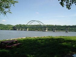
Mississippi River
| Mississippi River | |
|---|---|
| | |
| Origin | Lake Itasca |
| Mouth | Gulf of Mexico |
| Basin countries | United States (98.5%) Canada (1.5%) |
| Length | 3,733 km (2,320 mi) |
| Source elevation | 450 m (1,476 ft) |
| Avg. discharge | Minneapolis [1] : 210 m³/s (7,460 ft³/s) Saint Louis [1] : 5,150 m³/s (182,000 ft³/s ) Vicksburg [2] : 17,050 m³/s (602,000 ft³/s) Baton Rouge [3] : 12,740 m³/s (450,000 ft³/s) |
| Basin area | 2,980,000 km² (1,151,000 mi²) |
The Mississippi River, derived from the old Chippewa Indian word misi-ziibi meaning 'great river' (gichi-ziibi 'big river' at its headwaters), is the second-longest named river in North America, with a length of 2320 miles (3733 km) from Lake Itasca, Minnesota to the Gulf of Mexico in Lousianna. The longest named river in North America is its tributary, the Missouri River, with a length of 2341 miles (3767 km) from the confluence of the Jefferson River, Madison River, and Gallatin River to the Mississippi River. Taken together, the Jefferson, Missouri, and Mississippi form the largest river system in North America with a length of 3745 miles, making this combination the 3rd longest river in the world behind the Nile and Amazon Rivers. The Mississippi has one of the largest wetlands in the U.S. and is visited by 40% of all the ducks, geese and swans of North America. It also takes the runoff between the Appalachians to the Rocky Mountains accounting for one of the largest watersheds in the world. Mark Twain, one of America's most famous authors, centered his books, Life on the Mississippi and Huckleberry Fin from his memoirs of the Mississippi River. Two portions of the Mississippi were designated as some of the American Heritage Rivers in 1997.
Geography
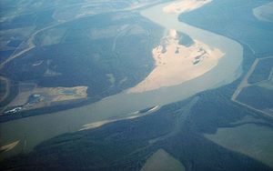
The Mississippi River is 2,348 miles long, the second longest river in the country after the Missouri River. Its source begins at Lake Itasca, 1,475 feet (450 m) above sea level in Itasca State Park, Minnesota. The river falls to 725 feet (220 m) just below Saint Anthony Falls in Minneapolis; the only waterfall along the river's course. The Mississippi passes through several glacial lakes, pine forests, vegetation, and cattail marshes, before it is joined by tributaries. The retention time from its beginning at Lake Itasca to the Gulf, its end, is about 90 days.
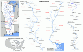
The Minnesota River and the Illinois River are among the first to join the Mississippi. The Missouri River joins the Mississippi near St. Louis, Missouri. Sometimes referred to as "The Big Muddy" it is the Mississippi's second largest tributary by volume. The Mississippi is also joined by the Ohio River at Cairo, Illinois and the Arkansas River near Arkansas Post, Arkansas. The Atchafalaya River in Louisiana is a major distributary of the Mississippi.
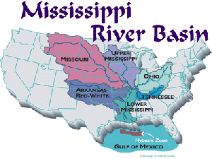
Its triangular drainage area covers about 40% of the U.S. and includes all or part of 31 states. It drains most of the area between the Rocky Mountains and the Appalachian Mountains except for the areas drained by Hudson Bay via the Red River of the North, the Great Lakes and the Rio Grande.
The Mississippi forms the borders of eight states; Wisconsin, Iowa, Illinois, Missouri, Kentucky, Arkansas, Tennessee and Mississippi, and runs through two others; Minnesota and Louisiana. The river empties into the Gulf of Mexico about 100 miles (160 km) downstream from New Orleans, Louisiana.
From its source to the Ohio River, the river is called the Upper Mississippi River, from the Ohio to its mouth it is known as the Lower Mississippi. The Upper Mississippi is further divided into three sections:
- the headwaters, from the source to Saint Anthony Falls
- a series of man-made lakes between Minneapolis and St. Louis, Missouri
- the middle Mississippi, a relatively free-flowing river downstream of the confluence with the Missouri River at St. Louis.
A series of 29 locks and dams on the upper Mississippi, most of which were built in the 1930s, is designed primarily to maintain a 9 foot (2.7 m) deep channel for commercial barge traffic. [4]
The lakes formed are also used for recreational boating and fishing. The dams make the river deeper and wider, but do not stop it. During periods of high flow, the gates, some of which are submersible, are completely opened and the dams simply cease to function. Below St. Louis, the Mississippi is relatively free-flowing, although it is constrained by numerous levees and directed by numerous wing dams.
Through a natural process known as deltaic switching, the lower Mississippi River has shifted its final course to the ocean every thousand years or so. This occurs because the deposits of silt and sediment raise the river's level causing it to eventually find a steeper route to the Gulf of Mexico. The abandoned distributary diminishes in volume and forms what are known as bayous. This process has, over the past 5,000 years, caused the coastline of south Louisiana to advance toward the Gulf from 15 to 50 miles (25-80 km).
The Mississippi River Delta Basin is defined as all of the land and shallow estuarine area between the two northernmost passes of the Mississippi River and the Gulf of Mexico. The basin is located in Plaquemines Parish, Louisiana, south of the city of Venice [5]
Course changes
The Illinoian Glacier, about 200,000 to 125,000 years before present, blocked the Mississippi River near present–day Rock Island, Illinois, diverting it to its present channel farther to the west, the current western border of Illinois. The Hennepin Canal roughly follows the ancient channel of the Mississippi downstream from Rock Island to Hennepin. South of Hennepin, Illinois, the current Illinois River is actually following the ancient channel of the Mississippi River (to Alton, Illinois) before the Illinoian glaciation.
Other changes in the course of the river have occurred because of earthquakes along the New Madrid Fault Zone, which lies between the cities of Memphis, Tennessee and St. Louis, Missouri. Three earthquakes in 1811 and 1812, estimated at approximately 8 on the Richter Scale, were said to have temporarily reversed the course of the Mississippi. These earthquakes also created Reelfoot Lake in Tennessee from the altered landscape near the river. The faulting is related to a failed rift (aulacogen) that formed at the same time as the Gulf of Mexico.
Watershed
The Mississippi River has the third largest drainage basin in the world, exceeded in size only by the watersheds of the Amazon and Congo Rivers. It drains 40% of the 48 contiguous states of the United States. The basin covers more than 1,250,000 square miles (1 E12 m²|3,225,000 km²), including all or parts of 31 states and two Canadian provinces, Manitoba and Ontario, or one-eighth of North America. [6]
Major tributaries of the Mississippi:
- Big Black River in Mississippi
- Red River in Louisiana
- White River in Arkansas
- Arkansas River in Arkansas
- Ohio River in Illinois and Kentucky
- Big Muddy River in Illinois
- Kaskaskia River in Illinois
- Missouri River in Missouri
- Illinois River in Illinois
- Des Moines River in Iowa
- Skunk River in Iowa
- Rock River in Illinois
- Maquoketa River in Iowa
- Wisconsin River in Wisconsin
- Chippewa River in Wisconsin
- St. Croix River in Wisconsin
- Minnesota River in Minnesota
Major sub-tributaries include the Tennessee River (a tributary of the Ohio River) and the Platte River (a tributary of the Missouri River).
Wildlife
In the 1960's and early 1970's, there were few regulations controlling what went into the river. DDT, a chemical used in fertilizers was a dangerous pollutant. During that time, the American Bald Eagle was nearly extinct, with only one nest in the Upper Mississippi River Wildlife Refuge. With the use of management and regulations, there are about 130 nests in the Refuge today. There are also about 300 bird species and 119 fish species living along and in the upper Mississippi River. The river affords homes for heron, egrets and large flocks of canvasback ducks. One can also see beautiful tundra swans and white pelicans along the river banks. Approximately 3.5 million poeple visit the upper Mississippi River Wildlife Refuge each year. [7]
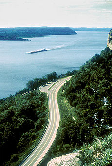
The Mississippi,its tributaries and waterways are visited by 40% of all ducks, geese, swans and eagles of the United States. The Great River Road allows visitors to travel on its roadways and view 2069 miles/ 3229.7km of scenic splendor through Arkansas, Illinois, Iowa, Minnesota, Mississippi, Missouri, and Wisconsin. [8]
Approximately 12 Million people live in the 125 counties and parishes along the Mississippi River. The Mississippi River Valley brings in $7 billion from forest and agriculture products and $29 million from manufacturing each year. Approximaately 470 million tons of cargo are moved on the Mississippi each year. Wheat from the mid-west and petro-chemicals from the Gulf of Mexico are among its major transports.
Controlling the channel
U.S. government scientists determined in the 1950s that the Mississippi River was starting to switch to the Atchafalaya River channel because of its much steeper path to the Gulf of Mexico, and eventually the Atchafalaya River would capture the Mississippi River and become its main channel to the Gulf of Mexico. As a result, the U.S. Congress authorized a project called the 'Old River Control Structure', which has prevented the Mississippi River from leaving its current channel that drains into the Gulf via New Orleans. Because of the large scale of high energy water flow through the structure threatening to damage the it, an auxiliary flow control station was built adjacent to the standing control station. This $300 million project was completed in 1986 by the Army Corp Of Engineers. This has actually caused many problems in the Mississippi River Delta Basin area in creating massive land loss. There are two plans in consideration designed to reverse the damage. One is the uncontrolled diversion of the Mississippi River for the creation of a new delta, while maintaining the navigation route in its present location. The other plan is that of managing the retreat of the existing delta. The second strategy would maintain the course of the river in its present location and would optimize the growth of the existing delta through redistribution of the available flows and sediments. [9]
River mouth flow
The Mississippi river discharges at an annual average rate of between 200,000 and 700,000 Cubic Feet per Second and releases about 400 million yards of mud, sand, and gravel per year. [10]
Although it is the 5th largest river in the world by volume, this flow is a mere fraction of the output of the Amazon, which moves nearly 7 million cfs during wet seasons. On average the Mississippi has only 1/11th the flow of the Amazon River, but is nearly twice that of the Columbia River and almost 6 times the volume of the Colorado River.
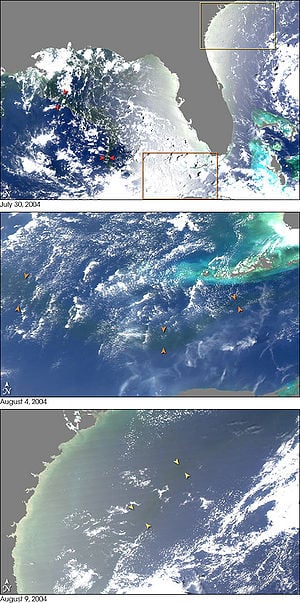
Fresh river water flowing from the Mississippi into the Gulf of Mexico does not mix into the salt water immediately. Images from NASA's MODIS (Moderate-resolution Imaging Spectroradiometer) show a large plume of fresh water, which appears as a dark ribbon against the lighter-blue surrounding waters. The Mississippi continues around the tip of Florida before it mixes thourouhly with the salt waters of the ocean. There is an ongoing effort to keep saltwater out of the Mississippi's fresh water before it enters the ocean. Saltwater wreaks havoc on the delicate habitat of fresh water biospheres inland.
Over the past 50 years, the sediment load of the Mississippi River Delta Basin has been drastically reduced by a combination of natural and human-induced factors. Natural factors include events such as hurricanes, tidal erosion, and sea-level rise. In 2005, Hurricane Katrina destroyed 700,000 acres of wetland habitat. Some areas of the Mississippi River Delta Basin, such as the Chandeleur Islands, lost about half of their land mass as a result of the powerful storm surge. [11]
History
Etymology
The name Mississippi is of Ojibwa origin, from Missi, meaning great, being akin to the more modern Kitchi or Gitchi plus Zibi meaning—the "Great River." Literally it means "River-of-the-Falls."
To the Ojibwa (or Chippewa), the Mississippi only becomes so below the junction of Leech Lake River, not Itasca as designated by the whites. Lake Itasca was the O-mush-kozo Sa-Gai-igan, "Elk Lake," and the stream running out, the O-mush-kozo Zibi, "Elk River." Rivers follow the general rule of taking the name of their immediate source lake. When reaching Lake Bemidji, Cass, and Winnibigoshish, this stream changed its name three more times and not until the outlet of Leech Lake is reached is it considered the Mississippi. [12]
European claims
On May 8, 1541, Hernando de Soto became the first recorded European to reach the Mississippi River, which he called "Rio de Espiritu Santo" (River of the Holy Spirit). This name is currently the name of the river in the Spanish speaking world.
French explorers Louis Joliet and Jacques Marquette were the first to make the river known to the European world through their voyage down the river from the mouth of the Wisconsin to the mouth of the Arkansas in 1673. In 1682, René Robert Cavelier, Sieur de La Salle and Henri de Tonty claimed the entire Mississippi River Valley for Louis XIV of France. They called the river Colbert River after Jean-Baptiste Colbert.
France lost all its territories on the North American mainland as a result of the French and Indian War. The Treaty of Paris (1763) gave the Kingdom of Great Britain rights to all land in the valley east of the Mississippi and Spain rights to land west of the Mississippi.
In the second Treaty of Paris (1783), Spain had control over the river south of 32°30' north latitude and, in what is known as the Spanish Conspiracy, hoped to gain greater control of Louisiana and all of the west. These hopes ended when Spain was pressured into signing Pinckney's Treaty in 1795. France reacquired 'Louisiana' from Spain in the secret Third Treaty of San Ildefonso in 1800. The United States bought the territory from France in the Louisiana Purchase of 1803.
The river played a decisive role in the American Civil War. The Union's Vicksburg Campaign called for Union control of the lower Mississippi River. The Union victory at the Battle of Vicksburg in 1863 was pivotal to the Union's final victory of the Civil War.
Two portions of the Mississippi were designated as some of the American Heritage Rivers in 1997, the lower portion around Louisiana and Tennessee, and the upper portion around Iowa, Illinois, Minnesota and Missouri.
EDITED TO HERE
Transportation
THIS SECTION NEEDS HISTORY — CHECK http://www.1911encyclopedia.org/Mississippi_River -------
Early forms of transportation along the Mississippi were "keel boats". These were rough rafts made of logs that were hauled to shore by ropes and pulled back up the river by various forms of locomotion. This process could take as long as 9 months. It was replaced by the use of steam engines.
The first steamboat to travel the full length of the Mississippi from the Ohio River to New Orleans, Louisiana, was the New Orleans in December 1811. Its maiden voyage occurred during the series of New Madrid earthquakes in 1811–12. By 1814 the New Orleans had a passenger and a cargo route . This route ran between New Orleans, Louisiana, and Natchez, Mississippi. Its speed was about 8 mph downstream and 3mph upstream.
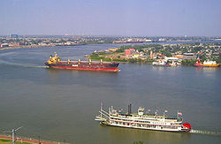
The invention of the combustable engine, in the mid 19th century, greatly speeded up river travel. Along with it came the invention and use of tow-boats and barges. The amount of cargo that one 15-barge tow could move, for example, was equal to approximately what 900 semi-trucks could haul and used only 10% of the fuel. By towboat, it takes approximately 7-9 days to cover the 669 miles. [13]
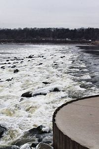
The barges and other vessels that make the Mississippi one of the great commercial waterways of the world require a clear channel. The task of maintaining a navigation channel is the responsibility of the U.S. Army Corps of Engineers, established in 1866. Projects on the river began as early as 1829 to remove snags, close off secondary channels and excavate rocks and sandbars. In 1829, there were surveys of the two major obstacles on the upper Mississippi, the Des Moines Rapids and the Rock Island Rapids, where the river was shallow and the riverbed was rock. The Des Moines Rapids were about 11 miles (18 km) long and just above the mouth of the Des Moines River at Keokuk, Iowa. The Rock Island Rapids were between Rock Island, Illinois and Moline, Illinois. Both rapids were considered virtually impassable. Because making the riverbed deeper wasn't plausable, a canal which opened in 1877 by-passed the Des Moines Rapids. The Moline Lock which opened in 1907 allowed passage of the Rock Island Rapids.
In 1848, the Illinois and Michigan Canal was built to connect the Mississippi River to Lake Michigan via the Illinois River near Peru, Illinois. In 1900, the canal was replaced by the Chicago Sanitary and Ship Canal. The canal allowed Chicago to address specific health issues (typhoid, cholera and other waterborne diseases) by sending its waste down the Illinois and Mississippi river systems rather than polluting its water source of Lake Michigan. The canal also provided a shipping route between the Great Lakes and the Mississippi.
To improve navigation between St. Paul, Minnesota, and Prairie du Chien, Wisconsin, the Corps constructed several dams on lakes in the headwaters area, including Lake Winnibigoshish and Lake Pokegama. The dams, which were built beginning in the 1880s, stored spring run-off which was released during low water to help maintain channel depth.
In 1913, construction was complete on a dam at Keokuk, Iowa, the first dam below St. Anthony Falls. Built by a private power company to generate electricity, the Keokuk dam was one of the largest hydro-electric plants in the world at the time. Besides producing electricity, this dam eliminated the Des Moines Rapids.
Until the 1950s, there was no dam below Lock and Dam 26 at Alton, Illinois. Lock and Dam 27, which consists of a low-water dam and an 8.4 mile (13.5 km) long canal, was added in 1953 just below the confluence with the Missouri River. This was created primarily to bypass a series of rock ledges at St. Louis. It also serves to protect the St. Louis city water intakes during times of low water.
Dam 26 at Alton, Illinois, which had structural problems, was replaced by the Mel Price Lock and Dam in 1990. The original Lock and Dam 26 was demolished.
Lock and Dam No. 1 was completed in Minneapolis in 1917 and Lock and Dam No. 2 at Hastings, Minnesota, was completed in 1930.
The Rivers and Harbors Act of 1930 authorized the 9-foot channel project, which called for a navigation channel 9 feet deep and 400 feet (120 m) wide to accommodate multiple-barge tows.[14][15] Twenty-three new locks and dams were built on the upper Mississippi in the 1930s in addition to the three already in existence. Two new locks were built north of Lock and Dam No. 1 at Saint Anthony Falls in the 1960s, extending the head of navigation for commercial traffic several miles. Oceanliners can travel up as far as Batan Rouge, Louisiana. Most barges travel as far Saint Paul and few venture farther.
Flood control
Prior to the 1927 flood, the Corps' primary strategy to stop flooding was to close off as many side channels as possible to increase the flow in the main river. It was thought that the river's velocity would scour off bottom sediments, deepening the river and decreasing the possibility of flooding. The 1927 flood proved this so wrong that communities threatened by the flood began to make their own levee breaks to relieve the tension of the rising river.The Great Flood of 1993 was another significant flood, although it primarily affected the Mississippi above its confluence with the Ohio River at Cairo, Illinois. The Corps now actievely creates floodways to divert periodic water surges into backwater channels and lakes.
There are now four major types of flood control used on the Mississippi. One is the use of embankments, including "wing" dams made of concrete, stones or various materials. and other barriors. This has proved to be one of the cheaper means of flood control and reduces erosion along the riverbanks. The second is by flood water storage techniques. The third is by the water diversion methods such as locks and dams, [16]The main floodways are the Birds Point-New Madrid Floodway; the Morganza Floodway, which directs floodwaters down the Atchafalaya River; and the Bonnet Carré Spillway which directs water to Lake Pontchartrain. The Old River Control structure also serve as major floodgates that can be opened to prevent flooding.The fourth method of controlling flood waters is to monitor and regulate the rivers carrying capacities.
Some of the pre-1927 strategy is still in use today; the Corps actively cuts the necks of horseshoe bends, allowing the water to move faster and reducing flood heights. This engineering procedure creates lakes that can also be used as floodways.
Beginning in the 1970s, the Corps applied hydrology transport models to analyze flood flow and water quality of the Mississippi. The use of computers have greatly aided in predicting and controlling the flow of water in the Mississippi.
Notable cities along the river
- Bemidji, Minnesota
- Minneapolis, Minnesota
- St. Paul, Minnesota
- La Crosse, Wisconsin
- Dubuque, Iowa
- Bettendorf, Iowa
- Davenport, Iowa
- Rock Island, Illinois
- Moline, Illinois
- Burlington, Iowa
- Quincy, Illinois
- Hannibal, Missouri
- St. Louis, Missouri
- Cairo, Illinois
- Memphis, Tennessee
- Greenville, Mississippi
- Vicksburg, Mississippi
- Natchez, Mississippi
- Baton Rouge, Louisiana
- New Orleans, Louisiana
Notable bridges
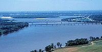
The first bridge across the Mississippi River was built in 1856. It spanned the river between Arsenal Island at Rock Island, Illinois and Davenport, Iowa. Steamboat pilots of the day, fearful of competition from the railroads, considered the new bridge "a hazard to navigation". Two weeks after the bridge opened, the steamboat Effie Afton rammed part of the bridge and started it on fire. Legal proceedings ensued - with a young lawyer named Abraham Lincoln defending the railroad. The lawsuit went all the way up to the Supreme Court, and was eventually ruled in favor of Lincoln and the railroad.
- Stone Arch Bridge - a former Great Northern Railroad (now pedestrian) bridge in Minneapolis and National Historic Engineering Landmark.
- Black Hawk Bridge, connecting Lansing, Iowa, Allamakee County, Iowa to rural Crawford County, Wisconsin, locally referred to as the Lansing Bridge and documented in the Historic American Engineering Record.
- Julien Dubuque Bridge - A bridge connecting Dubuque, Iowa and East Dubuque, Illinois that is listed in the National Register of Historic Places.
- Interstate 74 Bridge connecting Moline, Illinois to Bettendorf, Iowa is a twin suspension bridge, also known historically as the Iowa-Illinois Memorial Bridge.
- Rock Island Government Bridge connecting Rock Island, Illinois to Davenport,Iowa located just southwest of the site of the first bridge across the Mississippi River, it is one of only two bridges in the world with two sets of railroad tracks above the auto lanes. It also co-located with Lock and Dam #15 - the largest roller dam in the world.
- Rock Island Centennial Bridge connecting Rock Island, Illinois to Davenport, Iowa.
- Fort Madison Toll Bridge or Santa Fe Bridge - in Fort Madison, the largest double-deck swing-span bridge in the world; It is the last operating swing bridge over the Mississippi River for automobile traffic and is listed in the National Register of Historic Places.
- Clark Bridge also known as the Super Bridge as the result of an appearance on PBS program Nova. This cable-stay bridge constructed in 1994 connects Alton, Illinois to Black Jack, Missouri. It is the northernmost river crossing in the St. Louis metropolitan area and is named after explorer William Clark.
- Chain of Rocks Bridge - A bridge on the northern edge of St. Louis, Missouri; famous for a 22-degree bend halfway across and the most famous alignment of Historic US 66 across the Mississippi.
- Eads Bridge - A bridge connecting St. Louis, Missouri and East St. Louis, Illinois; the first major steel bridge in the world, and also a National Historic Landmark.
- Hernando de Soto Bridge - carries Interstate 40 to connect Memphis, Tennessee and West Memphis, Arkansas; listed in Guinness Book of World Records for its unique structural "letter" shape.
- Frisco Bridge - was the first crossing of the Lower Mississippi and the longest cantilever truss steel railroad bridge in North America when it opened on May 12, 1892. It connects Memphis, Tennessee and West Memphis, Arkansas and is listed as a Historic Civil Engineering Landmark.
- Memphis-Arkansas Memorial Bridge - the longest Warren truss- style bridge in the United States which carries Interstate 55 to connect Memphis, Tennessee and West Memphis, Arkansas; also listed on the National Register of Historic Places.
- Huey P. Long Bridge -Huey P. Long-Jefferson Parish, Louisiana, the first Mississippi River span built in Louisiana.
- Crescent City Connection - connects the east- and westbanks of New Orleans, Louisiana; the 5th-longest cantilever bridge in the world.
Notes
- ↑ 1.0 1.1 Median of the 7,305 daily mean streamflows recorded by the USGS for the period 1978-1998.
- ↑ Median of the 7,305 daily mean streamflows recorded by the USGS for the period 1978-1998 at Vicksburg. The discharge is probably even higher farther downstream at Natchez, but data for Natchez were not recorded. Farther downstream from Natchez, approximately 25 percent of the water discharge of the Mississippi is diverted into the Atchafalaya River, and further discharge is lost as the river becomes a delta in Louisiana.
- ↑ Median of the 1,826 daily mean streamflows recorded by the USGS for the period 1978-1983 at Baton Rouge.
- ↑ December 2005. Mississippi River, USGS: Status and trends of the nation's biological resources. Retrieved March 31, 2007.
- ↑ 1993. Mississippi River Delta Basin: Summary of Basin Plan, Louisiana Coastal Wetlands Conservation and Restoration Task Force. Retrieved March 31, 2007.
- ↑ Mississippi River, Visit Bemidji. Retrieved March 31, 2007.
- ↑ Record Number of Bald Eagles Call the Upper Mississippi River National Wildlife and Fish Refuge Home, Bird Watcher's Digest. Retrieved March 31, 2007.
- ↑ Great River Road, See America.org. Retrieved April 2, 2007.
- ↑ 1993. Mississippi River Delta Basin: Summary of Basin Plan, Louisiana Coastal Wetlands Conservation and Restoration Task Force. Retrieved March 31, 2007.
- ↑ Mississippi River Anatomy, Loyola University's Center for Environmental Communication and America's WETLAND: A Campaign to Save Coastal Louisiana. Retrieved March 31, 2007.
- ↑ The Mississippi River Delta, WGBH Educational Foundation. Retrieved March 31, 2007.
- ↑ Durand, Paul. Ha-Ha Wa-Kpa (Mississippi River-Dakota), The Dakota Society. Retrieved March 31, 2007.
- ↑ http://inventors.about.com/library/inventors/blsteamship.html
- ↑ The Mississippi and its Uses. Natural Resource Management Section, Rock Island Engineers. Retrieved 2006-06-21.
- ↑ Appendix E: Nine-foot navigation channel maintenance activities. National Park Service, Mississippi National River and Recreation Area Comprehensive Management Plan. Retrieved 2006-06-21.
- ↑ tc.engr.wise.edu/Steuber/paper/1996/river.html
Further reading
- Penn, James R, Rivers of the world : a social, geographical, and environmental sourcebook, California, ABC-CLIO, 2001, ISBN 1576070425 - ISBN 1576075796
- Bartlett, Richard A , Rolling rivers : an encyclopedia of America's rivers, New York, McGraw-Hill, 1984, ISBN 0070039100
- Prevost, John F, Mississippi River, Minnesota, Abdo Pub., 2002, ISBN 1577651022
External links
- General Information about the Mississippi River, Mississippi National River and Recreation Area, Accessed March 19, 2007
- Estrada, David, Life on the Mississippi River, Life on the River, Accessed March 19, 2007
Credits
New World Encyclopedia writers and editors rewrote and completed the Wikipedia article in accordance with New World Encyclopedia standards. This article abides by terms of the Creative Commons CC-by-sa 3.0 License (CC-by-sa), which may be used and disseminated with proper attribution. Credit is due under the terms of this license that can reference both the New World Encyclopedia contributors and the selfless volunteer contributors of the Wikimedia Foundation. To cite this article click here for a list of acceptable citing formats.The history of earlier contributions by wikipedians is accessible to researchers here:
The history of this article since it was imported to New World Encyclopedia:
Note: Some restrictions may apply to use of individual images which are separately licensed.
