Difference between revisions of "Easter Island" - New World Encyclopedia
Mike Butler (talk | contribs) (Easter island - importing) |
Mike Butler (talk | contribs) m |
||
| Line 198: | Line 198: | ||
==Blogs== | ==Blogs== | ||
* [http://natandsteve.blogspot.com/2006/03/easter-island-rapa-nui.html Easter Island (Rapa Nui)] | * [http://natandsteve.blogspot.com/2006/03/easter-island-rapa-nui.html Easter Island (Rapa Nui)] | ||
| − | + | {{credit|42893118}} | |
| − | {{ | ||
| − | |||
| − | |||
| − | |||
| − | |||
| − | |||
| − | |||
| − | |||
| − | |||
| − | |||
| − | |||
| − | |||
| − | |||
| − | |||
| − | |||
| − | |||
| − | |||
| − | |||
| − | |||
| − | |||
| − | |||
| − | |||
| − | |||
| − | |||
| − | |||
| − | |||
| − | |||
| − | |||
| − | |||
| − | |||
| − | |||
| − | |||
| − | |||
| − | |||
| − | |||
| − | |||
| − | |||
| − | |||
| − | |||
| − | |||
| − | |||
| − | |||
| − | |||
Revision as of 08:31, 11 June 2006
| |||
| City motto: (" Rapa Nui" ) Also called "Ombligo del mundo (Navil of the world)" | |||
| Discovered | April 5, 1722 by Jakob Roggeveen, | ||
| Capital | Hanga Roa | ||
| Area - City Proper |
163,6 km² | ||
| Population - City (2005) - Density (city proper) |
3.791 Inhabitants 23,17 /km² | ||
| Time zone | Central Time zone, UTC- 6 | ||
| Telephone Prefix | 32 | ||
| Postal code | 2779001 | ||
| Gentilic | Pascuense | ||
| Mayor | Pedro Pablo Edmunds Paoa (PDC) (2004-2008) | ||
| Official site | http://www.rapanui.co.cl | ||
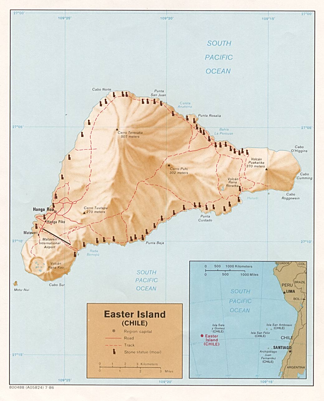
File:Easter island (Chile).jpg Map of Easter Island. | |||
Easter Island (Rapa Nui: Rapa Nui ("Big Rapa")) is an island in the south Pacific Ocean belonging to Chile. Located 3,600 km (2,237 statute miles) west of continental Chile and 2,075 km (1,290 statute miles) east of Pitcairn Island, it is one of the most isolated inhabited islands in the world. It is located at 27°09′S 109°27′W, with a latitude close to that of the Chilean city of Copiapó, north of Santiago. The island is approximately triangular in shape, with an area of 163.6 km² (63 sq. miles), and a population of 3,791 (2002 census), 3,304 of which live in the capital of Hanga Roa. Easter is made up of three volcanoes: Poike, Rano Kau and Terevaka. The island is famous for its numerous moai, the stone statues now located along the coastlines. Administratively, it is a province (containing a single municipality) of the Chilean Valparaíso Region. The standard time is six hours behind UTC (UTC-6) (five hours behind including one hour of daylight saving time).
History
Oral traditions and early history
Early European visitors to Easter Island recorded the local oral traditions of the original settlers. In these traditions, Easter Islanders claimed that a chief Hotu Matu'a arrived on the island in one or two large canoes with his wife and extended family. There is considerable uncertainty about the accuracy of this legend as well as the date of settlement. Published literature suggests the island was settled around AD 300-400, or at about the time of the arrival of the earliest (non-Polynesian) settlers in Hawaii. Some scientists say that Easter Island was not inhabited until the later years of AD 700-800. This date range is based on glottochronological calculations and on three radiocarbon dates from charcoal that appears to have been produced during forest clearance activities. (Diamond 2005:89) On the other hand, a recent study, including radiocarbon dates from what is thought to be very early materials, indicates that the island was settled as recently as AD 1200, the time of the deforestation of the island (Hunt and Lipo 2006).
The Polynesians, who arguably settled the island are likely to have arrived from the Marquesas Islands from the west. These settlers brought bananas, taro, sweet potato, sugarcane, and paper mulberry, as well as pigs, chickens, and rats. The island at one time supported a relatively advanced and complex civilization.
European contact with the island began in 1722 on Easter Sunday when Dutch navigator Jacob Roggeveen found about 2,000-3,000 inhabitants on the island, although the population may have been as high as 10,000-15,000 only a century or two earlier. The civilization of Easter Island was long believed to have degenerated drastically during the 100 years before the arrival of the Dutch, as a result of overpopulation, deforestation and exploitation of an extremely isolated island with limited natural resources. Evidence to support this sudden collapse is that the oral traditions of the islanders are obsessed with cannibalism. To severely insult an enemy one would say: "The flesh of your mother sticks between my teeth". This suggests that the food supply of the people ultimately ran out. (Diamond 2005:109)

All that can be said is that there was a massive, anthropogenic alteration of the ecosystem, and subsequently a cultural transition while a conclusion cannot be drawn for a catastrophic event. By the mid-19th century the population had recovered to about 4,000. Then in a mere 20 years, deportation via slave traders to Peru and diseases brought by Westerners almost exterminated the whole population - only 110 inhabitants were left on the island in 1877.
It is more likely these events (recollected by the surviving descendants) have led to the belief that they described ancient memories of a pre-contact collapse.
Easter Island was annexed for Chile in 1888 by Policarpo Toro. The native Rapanui have since gradually recovered from this low point in their numbers.
Moai-carving culture (?10th century CE - ?16th/17th century CE)
Trees are sparse on modern Easter Island, rarely forming small groves. The island once possessed a forest of palms and it has generally been thought that native Easter Islanders deforested the island in the process of erecting their statues. Experimental archaeology has clearly demonstrated that some statues certainly could have been placed on wooden frames and then pulled to their final destinations on ceremonial sites. Rapanui traditions metaphorically refer to spiritual power (mana) as the means by which the moai were "walked" from the quarry. Also important was the introduction of the Polynesian rat, which apparently ate the palm's seeds. However, given the island's southern latitude, the (as yet poorly documented) climatic effects of the Little Ice Age (about 1650 to 1850) may have contributed to deforestation and other changes. The disappearance of the island's trees seems to coincide with a decline of the Easter Island civilization around the 17th-18th century AD. Midden contents show a sudden drop in quantities of fish and bird bones as the islanders lost the means to construct fishing vessels and the birds lost their nesting sites. Soil erosion due to lack of trees is apparent in some places. Sediment samples document that up to half of the native plants had become extinct and that the vegetation of the island was drastically altered. Chickens and rats became leading items of diet and there are (not unequivocally accepted) hints at cannibalism occurring, based on human remains associated with cooking sites, especially in caves. Obsidian spear points and the toppling of many statues indicate a breakdown of the social structure, possibly even leading to civil strife, though almost certainly not on as massive a scale as is often assumed.
Thor Heyerdahl pointed out many cultural similarities between Easter Island and South American Indian cultures. However, present-day Polynesian archeology strongly denies any non-Polynesian influence on the island's prehistory, and the discussion has become very political around the subject. Furthermore, DNA analyses of Easter Island's inhabitants offers strong evidence as to their Polynesian origins, a tool not available in Heyerdahl's time.
Some scholars have argued Polynesian sailors may have reached the central-south coast of Chile. Some "Polynesian-like" cultural traits, including words like toki, have been described among the Mapuche people from southern Chile.
The Birdman cult (?16th/17th century CE - 19th century CE)
The surviving population developed new traditions to allot the remaining resources. In the cult of the birdman (Rapanui: tangata manu), a competition was established in which every year a representative of each clan, chosen by the leaders, would dive into the sea and swim across to Motu Nui, a nearby islet, to search for the season's first egg laid by a manutara (sooty tern). The first swimmer to return with an egg would secure control over distribution of the island's resources for his clan for the year. The tradition was still in existence at the time of first contact by Europeans.
Whatever the reasons for this apparent decline, it was European intervention that delivered the final blow to Rapanui culture. In his article From Genocide to Ecocide: The Rape of Rapa Nui, Benny Peiser notes evidence of self-sufficiency on Easter Island when Europeans first arrived. Although stressed, the island may still have had at least some (small) trees remaining, mainly toromiro. Cornelis Bouman, Jakob Roggeveen's captain, stated in his log book, "...of yams, bananas and small coconut palms we saw little and no other trees or crops." According to Carl Friedrich Behrens, Roggeveen's officer, "The natives presented palm branches as peace offerings. Their houses were set up on wooden stakes, daubed over with luting and covered with palm leaves," indicating living palm trees were still available, though these were likely coconuts introduced after the extinction of the native palm.
Easter Island has suffered from heavy soil erosion during recent centuries. Largely, this condition emerged as a result of massive deforestation. However, this process seems to have been gradual and may have been aggravated by extensive sheep farming throughout most of the 20th century. Jakob Roggeveen reported that Easter Island was exceptionally fertile, producing large quantities of bananas, potatoes and thick sugar-cane. In 1786 M. de La Pérouse visited Easter Island and his gardener declared that "three day's work a year" would be enough to support the population.
Rollin, a major of the French expedition to Easter Island in 1786, wrote, "Instead of meeting with men exhausted by famine... I found, on the contrary, a considerable population, with more beauty and grace than I afterwards met in any other island; and a soil, which, with very little labour, furnished excellent provisions, and in an abundance more than sufficient for the consumption of the inhabitants." (Heyerdahl & Ferdon, 1961:57).
Most of the adult males were abducted and enslaved by Peruvians in the middle of the 19th century.
Today
Until the 1960s, the surviving Rapanui descendants were forced to live in a confined settlement in squalid conditions at the outskirts of Hanga Roa. Since finally being allowed to live free, they have re-embraced their ancient culture, or what could be reconstructed of it. A yearly cultural festival, the Tapati celebrates native pastimes.
Rapa Nui is not the island's original name. It was coined by labour immigrants from Rapa in the Bass Islands, who likened it to their home island. The Rapanui name for Rapa Nui was Te pito o te henua (The Navel of the World) due to its isolation, but this too seems to have been derived from another location, possibly a Marquesan landmark.
Recent events have shown a tremendous increase of tourism on the island, coupled with a large inflow of people from mainland Chile which threatens to alter the Polynesian identity of the island. Land disputes have created political tensions since the 1980s, with part of the native Rapanui opposed to private property and in favor of traditional communal property (see Demography below).
Mataveri International Airport serves as the island's only airport. The airport's single 2903 m (9524 ft) runway was lengthened by the U.S. space program to serve as an alternate emergency landing site for the space shuttle.
Ecology

.jpg)
Easter Island, together with its closest neighbor, the tiny island of Sala-y-Gomez 400 km further East, is recognized by ecologists as a distinct ecoregion, called the Rapa Nui subtropical broadleaf forests. Having relatively little rainfall contributed to eventual deforestation. The original subtropical moist broadleaf forests are now gone, but paleobotanical studies of fossil pollen and tree molds left by lava flows indicate that the island was formerly forested, with a range of trees, shrubs, ferns, and grasses. A large palm, related to the Chilean wine palm (Jubaea chilensis) was one of the dominant trees, as was the toromiro tree (Sophora toromiro). The palm is now extinct, and the toromiro is extinct in the wild, and the island is presently covered almost entirely in grassland. A group of scientists partly led jointly by the Royal Botanic Gardens, Kew and the Göteborg Botanical Garden, are making efforts in order to reintroduce the toromiro to Easter Island. An interesting fact is the presence of the bulrush nga'atu which is also found in the Andes (where it is known as totora); there are indications that nga'atu was not present before the 1300s-1500s. Before the arrival of humans, Easter Island had vast seabird colonies, no longer found on the main island, and several species of landbirds, which have become extinct.
"The overall picture for Easter is the most extreme example of forest destruction in the Pacific, and among the most extreme in the world: the whole forest gone, and all of its tree species extinct." Diamond 2005 p.107.
Cultural artifacts
The Moai
The large stone statues, or moai, for which Easter Island is world famous were carved during a relatively short and intense burst of creative and productive megalithic activity. Archeologists now estimate that ceremonial site construction and statue carving took place largely between about AD 1100 and 1600 and may have consumed up to 25% of island-wide resources — with some statues probably still being carved at about the time Jacob Roggeveen arrived. According to recent archaeological research 887 monolithic stone statues, called moai, have been inventoried on the island and in museum collections. This number is not final, however. The on-going statue survey continues to turn up new fragments, and mapping in Rano Raraku quarry (see below) has documented more unfinished statues than previously known. In addition, some statues incorporated into ceremonial site construction surely remain to be uncovered. Although often identified as "heads", the statues actually are heads and complete torsos. Some upright moai, however, have become buried up to their necks by shifting soils. Most moai were carved out of a distinctive, compressed easily-worked volcanic ash or tuff found at a single site called Rano Raraku. The quarry there seems to have been abandoned abruptly, with half-carved statues left in the rock. However, on closer examination the pattern of use and abandonment is more complex. The most widely-accepted theory is that the statues were carved by the ancestors of the modern Polynesian inhabitants (Rapanui) at a time when the island was largely planted with trees and resources were plentiful, supporting a population of at least 10,000-15,000 native Rapanui. The majority of the statues were still standing when Jacob Roggeveen arrived in 1722. Captain James Cook also saw many standing statues when he landed on the island in 1774. By the mid-19th century, all the statues had been toppled, presumably in internecine wars.
As impressive as the statues are, the ahu platforms contained 20 times as much stone, and actually required even greater resources to build.
Stone Chicken Houses
There is archaeological evidence of intensive agriculture, including 1,233 prehistoric stone chicken houses (hare moa), which are more conspicuous than the remains of the prehistoric human houses (which only had stone foundations). They were 20 or more feet long, 10 feet wide, with a small entrance for the chickens connecting to a stone-walled yard.
Rongorongo
Tablets found on the island and bearing a mysterious script known as Rongorongo have never been deciphered despite the work of generations of linguists. In 1932 Hungarian scholar Wilhelm or Guillaume de Hevesy called attention to apparent similarities between some of the rongorongo characters of Easter Island and the prehistoric script of the Indus Valley in India, correlating dozens (at least 40) of the former with corresponding signs on seals from Mohenjo-daro. This correlation was re-published in later books, for example by Z.A. Simon (1984: 95), but later works showed these comparisons to be spurious.
Some writers have asserted rongorongo means peace-peace and that their texts record peace treaty documents, possibly between the long ears and the conquering short ears. However, such explanations have been strongly disputed, particularly since the "long-ear/short ear" designations of historical islanders have become increasingly unsupportable.
Like most indigenous tellers of Easter Island histories or legends, islanders continue to have questionable motives for their accounts and have always been creative, imaginative and quick to give answers to inquisitive archaeologists and historians. Rongorongo's purpose and intent remain as puzzling as the script's meaning. While there have been many claims of translation, none have withstood peer review and become generally accepted.
Demography
Population at the 2002 census was 3,791 inhabitants, up from 1,936 inhabitants in 1982. This tremendous increase in population is due mainly to the arrival of people of European descent from the mainland of Chile. Consequently, the island is losing its native Polynesian identity. In 1982 around 70% of the population were Rapanui (the native Polynesian inhabitants). At the 2002 census however, Rapanui were only 60% of the population of Easter Island. Chileans of European descent were 39% of the population, and the remaining 1% were Native American from mainland Chile. 3,304 of the 3,791 inhabitants of the island live in the town of Hanga Roa.
Rapanui have also migrated out of the island. At the 2002 census there were 2,269 Rapanui living in Easter Island, while 2,378 Rapanui lived in the mainland of Chile (half of them in the metropolitan area of Santiago).
Population density on Easter Island is only 23 inhabitants per km² (60 inh. per sq. mile), much lower than in the 17th century heyday of the moai building when there were between 10,000 and 15,000 native Rapanui on the island. Population had already declined to only 2,000-3,000 inhabitants before the arrival of Europeans. In the 19th century, disease due to contacts with Europeans, as well as deportation of 2,000 Rapanui to work as slaves in Peru, and the forced departure of the remaining Rapanui to Chile, carried the population of Easter Island to the all time low of 111 inhabitants in 1877. Out of these 111 Rapanui, only 36 had descendants, and they are the ancestors of all the 2,269 Rapanui currently living on the island.
Mythology
- Hiro
- Kumulipo
- Makemake
- Polynesian mythology
See also
- Rapa Nui language
- Rongorongo
- Thor Heyerdahl
- Rapa Nui (film)
- Kings of Easter Island
ReferencesISBN links support NWE through referral fees
- Diamond, Jared. Collapse: How Societies Choose to Fail or Succeed. Penguin Books: 2005. ISBN 0143036556. Chapter 2: Twilight at Easter pp.79-119.
- Hunt, T. L., Lipo, C. P., 2006. Science, 1121879. URL Late Colonization of Easter Island
Selected bibliography
- BARTHEL, Thomas. 1958. Grundlagen zur Entzifferung der Osterinselschrift. Hamburg : Cram, de Gruyter.
- BUTINOV, Nikolai A., & Yuri V. KNOROZOV. 1957. Preliminary Report on the Study of the Written Language of Easter Island. Journal of the Polynesian Society 66. 1.
- ENGLERT, Sebastian F. 1970. Island at the Center of the World. Translated and Edited by William Mulloy. New York: Charles Scribner's Sons.
- FEDOROVA, Irina K. 1965. Versions of Myths and Legends in Manuscripts from Easter Island. In: Heyerdahl et al (eds.), Miscellaneous Papers: Reports of the Norwegian Archaeological Expedition to Easter Island and East Pacific 2. 395-401. Stockholm: Forum.
- FISCHER, Steven Roger. 1995. Preliminary Evidence for Cosmogonic Texts in Rapanui’s Rongorongo Inscriptions. Journal of the Polynesian Society 104. 303-21.
- FISCHER, Steven Roger. 1997. Glyph-breaker: A Decipherer's Story. N.Y.: Copernicus/Springer-Verlag.
- FISCHER, Steven Roger. 1997. RongoRongo, the Easter Island Script: History, Traditions, Texts. Oxford and N.Y.: Oxford University Press.
- GUY, Jacques B.M. 1985. On a fragment of the “Tahua” Tablet. Journal of the Polynesian Society 94. 367-87.
- GUY, Jacques B.M. 1988. Rjabchikov’s Decipherments Examined. Journal of the Polynesian Society 97. 321-3.
- GUY, Jacques B.M. 1990. On the Lunar Calendar of Tablet Mamari. Journal de la Société des Océanistes 91:2.135-49.
- HEYERDAHL, Thor. 1965. The Concept of Rongorongo Among the Historic Population of Easter Island. In: Thor Heyerdahl & Edwin N. Ferdon Jr. (eds. and others.), 1961-65. Stockholm: Forum.
- IMBELLONI, José. 1951. Las Tabletas Parlantes de Pascua, Monumentos de un Sistema Gráfico Indo-oceánico. Runa 4. 89-177.
- LEE, Georgia. 1992. The Rock Art of Easter Island. Symbols of Power, Prayers to the Gods. Los Angeles: The Institute of Archaeology Publications (UCLA).
- MÉTRAUX, Alfred. 1940. Ethnology of Easter Island. Bernice P. Bishop Museum Bulletin 160. Honolulu: Bernice P. Bishop Museum Press.
- POZDNIAKOV, Konstantin. 1996. Les Bases du Déchiffrement de l'Écriture de l'Ile de Pâques. Journal de la Societé des Océanistes 103:2.289-303.
- RJABCHIKOV, Sergei V. 1987. Progress Report on the Decipherment of the Easter Island Writing System. Journal of the Polynesian Society, 96: 361-736.
- RJABCHIKOV, Sergei V. 1988. Allographic Variations of Easter Island Glyphs. Journal of the Polynesian Society, 97: 313-320.
- RJABCHIKOV, Sergei V. 1989. Novye dannye po starorapanuyskomu yazyku. Sovetskaya etnografiya, 6: 122-125.
- RJABCHIKOV, Sergei V. 1993. Rapanuyskie texty (k probleme rasshifrovki). Etnograficheskoe obozrenie, 4: 124-141.
- RJABCHIKOV, Sergei V. 1997. Easter Island Writing: Speculation and Sense. Journal of the Polynesian Society, 106: 203-205.
- RJABCHIKOV, Sergei V. 1997. A Key to the Easter Island (Rapa Nui) Petroglyphs. Journal de la Société des Océanistes, 104(1): 111.
- RJABCHIKOV, Sergei V. 1998. Polynesian Petroglyphs: Reports about Solar Eclipses. Journal de la Société des Océanistes, 107(2): 231-232.
- RJABCHIKOV, Sergei V. 1999. [A Review:]Fischer, Steven Roger, 1997. Glyphbreaker, New York, Copernicus. Journal de la Société des Océanistes, 108(1): 168-169.
- RJABCHIKOV, Sergei V. 1999. [A Review:]Fischer, Steven Roger, 1997. Glyphbreaker, New York, Copernicus. Word, 50(3): 440-441.
- RJABCHIKOV, Sergei V. 1999. Guy's Reviews Examined. RONGORONGO, Easter Island Writing.
- RJABCHIKOV, Sergei V. 2000. La trompette du dieu Hiro. Journal de la Société des Océanistes, 110(1): 115-116.
- RJABCHIKOV, Sergei V. 2001. Fijian and Polynesian String Figures Help Decipher Fijian Petroglyphs. Bulletin of the International String Figure Association, 8: 39-45.
- RJABCHIKOV, Sergei V. 2001. Rongorongo Glyphs Clarify Easter Island Rock Drawings. Journal de la Société des Océanistes, 113(2): 215-220.
- ROUTLEDGE, Katherine. 1919. The Mystery of Easter Island. The story of an expedition. London.
- THOMSON, William J. 1891. Te Pito te Henua, or Easter Island. Report of the United States National Museum for the Year Ending June 30, 1889. Annual Reports of the Smithsonian Institution for 1889. 447-552. Washington: Smithsonian Institution.
- VAN TILBURG, Jo Anne. 1994. Easter Island: Archaeology, Ecology and Culture. Washington D.C.: Smithsonian Institution Press.
External links
- Travel guide to Easter Island from Wikitravel
- "Easter Island and Its Mysteries" Translation of the 1934 classic by Stéphen-Chauvet
- Guide to Easter Island from the Easter Island Foundation
- PBS NOVA: Secrets of Easter Island
- RONGORONGO by Sergei V. Rjabchikov
- RONGORONGO, Easter Island Writing by Sergei V. Rjabchikov
- Several Rongorongo Records (Symbolism of Archaic Beliefs) by Sergei V. Rjabchikov
- http://www.sscnet.ucla.edu/ioa/eisp/ Field work reports of the Easter Island Statue Project
- BBC Horizon: The Mystery of Easter Island
- Easter Island Research
- The Easter Island Story from Mysterious Places
- Open Directory Project: Easter Island
- Easter Island from Sacred Destinations
- Easter Island
- Finding Easter Island
- Rongorongo, the hieroglyphic script of Easter Island, has remained a mystery since its discovery
- Map of Easter Island from Map South Pacific
- Map of Easter Island from the Perry-Castañeda Library Map Collection.
- Easter's End by Jared Diamond.
- "Let Sleeping Moai Lie" by Roderick Eime
- Eastern Island - Myth - story of HOTU MATUA.
- Rapa Nui subtropical broadleaf forests (World Wildlife Fund)
- From Genocide to Ecocide: The Rape of Rapa Nui by Benny Peiser
- Interview with Bill Basener, the man who created a mathematical model of the society's collapse
- Pictures of Easter Island from Chmouel Boudjnah photos travel's collection.
- Easter Island Travel Photos by the author of Moon Handbooks South Pacific
- Flickr: Photos tagged with easterisland
- Easter Island Fact sheet with photographs
- A handbook for Rapanui anthropology, archaeology, management and history, in Spanish
- News report of recent dating, indicating ca. AD 1200 settlement
Blogs
Credits
New World Encyclopedia writers and editors rewrote and completed the Wikipedia article in accordance with New World Encyclopedia standards. This article abides by terms of the Creative Commons CC-by-sa 3.0 License (CC-by-sa), which may be used and disseminated with proper attribution. Credit is due under the terms of this license that can reference both the New World Encyclopedia contributors and the selfless volunteer contributors of the Wikimedia Foundation. To cite this article click here for a list of acceptable citing formats.The history of earlier contributions by wikipedians is accessible to researchers here:
The history of this article since it was imported to New World Encyclopedia:
Note: Some restrictions may apply to use of individual images which are separately licensed.