Difference between revisions of "Jordan River" - New World Encyclopedia
Mary Anglin (talk | contribs) |
Mary Anglin (talk | contribs) |
||
| Line 35: | Line 35: | ||
== Geography == | == Geography == | ||
| + | The Jordan River is shallow, with its high-water period lasting from January to March, while its low-water period occurs at the end of summer and the beginning of autumn. Its current is swift, carrying a heavy load of silt. It is unnavigable due to its precipitous upper course, its seasonal flow, and its shallow, twisting lower course. | ||
| − | + | The River's high degree of salinity is due to the existance of thermal springs, mainly in the [[Tiberias]] region on the western side of the [[Sea of Galilee]]. There is also a high concentration of [[gypsum]]. Irrigation waters often leave a salt residue in the soil. | |
| − | In | + | In modern times the waters are 70 to 90 percent used for human purposes and the flow is much reduced. Because of this and the high evaporation rate of the Dead Sea, the sea is shrinking. All the shallow waters of the southern end of the sea have been drained in modern times and are now salt flats. |
| − | + | The waters of the Jordan are an extremely important resource to the dry lands of the area and have been a source of conflict between [[Lebanon]], [[Syria]], [[Jordan]], [[Israel]] and the [[Palestine]]. | |
| − | + | === The River Valley === | |
| + | The Jordan Valley runs north — south, forming part of the Great Rift Valley which extends 4,000 miles from northern [[Syria]] to central [[Mozambique]] in [[East Africa]]. The Jordan Valley itself is long and narrow, averaging only 6 miles (10 km) in width. It is much lower than its surrounding landscape, with steep, sheer, bare walls. | ||
| − | The | + | The Hula Valley receives approximately 22 inches (550 mm) of rainfall per year, but only about 3 inches (75 mm) fall north of the Dead Sea. The Jordan Valley is fed by rains falling on the neighboring plateaus, through the wadi system which flow through the valley. |
| − | [[ | + | === Environmental concerns === |
| + | In 1964 [[Israel]] began operating a [[dam]] that diverts water from the Sea of Galilee, a major Jordan River water provider, to the national water carrier. In the same year, [[Jordan]] constructed a channel that diverted water from the [[Yarmouk River]], another main tributary of the Jordan River. These acts resulted in great damage to the [[ecosystem]]. | ||
| − | + | [[Syria]] has also built reservoirs that catch the Yarmouk's waters. It is feared that Yarmouk's flow into the Jordan River could dwindle to a trickle, when a dam built jointly by Syria and Jordan begins operating. | |
| − | |||
| − | + | [[Environmentalism|Environmentalists]] blame [[Israel]], [[Jordan]] and [[Syria]] for the loss of freshwater foliage that once flourished along the river's banks. It has been replaced with saline vegetation due to the three countries replenishment of the river with sewage water, agricultural runoff and salt water, | |
| − | + | == Biblical Reference== | |
| + | In the [[Hebrew]] [[Bible]], the Jordan is referred to as the source of fertility to a large plain ("Kikkar ha-Yarden"), called on account of its luxuriant vegetation "the garden of [[God]]" (Genesis 13:10). | ||
| − | + | The Bible offers scattered and indefinite references to the Jordan River. [[Jacob]] crossed it and its tributary, the [[Jabbok]], in order to reach [[Haran]] (Gen. 32:11, 23-24). It is noted as the line of demarcation between the "two tribes and the half tribe" settled to the east (Numbers 34:15) and the "nine tribes and the half tribe of Manasseh" that, led by [[Joshua]], settled to the west (Josh. 13:7). | |
| − | + | Opposite [[Jericho]] it was called "the Jordan of Jericho" (Num. 34: 15, 35: 1). The Jordan has a number of ford crossings, one of which is famous as the place where many Ephraimites were slain by Jephthah (Judges 12:5-6). It seems that these are the same fords mentioned as being near Beth-barah, where Gideon lay in wait for the Midianites (Judges 7:24). In the plain of the Jordan, between Succoth and Zarthan, is the clay ground where Solomon's brass foundries were located (I Kings 7:46). | |
| − | + | In Biblical history the Jordan appears as the scene of several [[miracle]]s, the first taking place when the Jordan, near [[Jericho]], was crossed by the [[Israelite]]s under [[Joshua]] (Josh. iii. 15-17). Later the two tribes and the half tribe that settled east of the Jordan built a large altar on its banks as "a witness" between them and the other tribes (Josh. xxii. 10, 26 et seq.). The Jordan was said to be crossed dry-shod by [[Elijah]] and [[Elisha]] (II Kings 2: 8, 14). Elisha performed two other miracles at the Jordan: he healed Naaman by having him bathe in its waters, and he made the ax of one of the children of the prophets float, by throwing a piece of wood into the water (II Kings 5:14, 6:6). | |
| − | |||
| − | + | The Jordan was crossed by [[Judas Maccabeus]] and his brother [[Jonathan Maccabaeus]] during their war with the Nabatæans (1 Maccabees 5:24). Soon after, the Jordan was the scene of the battle between Jonathan and [[Bacchides]], in which the latter was defeated (I Macc. 9:42-49). | |
| − | |||
| − | |||
| − | |||
| − | The Jordan was crossed by [[Judas Maccabeus]] and his brother [[Jonathan Maccabaeus]] during their war with the Nabatæans ( | ||
The [[New Testament]] states that [[John the Baptist]] baptized [[Jesus]] in the Jordan (Matt. 3:13). | The [[New Testament]] states that [[John the Baptist]] baptized [[Jesus]] in the Jordan (Matt. 3:13). | ||
| − | |||
| − | |||
==Symbolic importance== | ==Symbolic importance== | ||
Revision as of 10:22, 25 June 2007
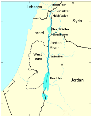
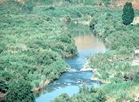
The Jordan River (Arabic language: Nahr Al-Urdun, Hebrew language: Ha-Yarden River) is a river in Southwest Asia flowing through the Great Rift Valley into the Dead Sea. The Jordan River, with the lowest elevation of any river in the world, rises at the Syrian-Lebanese border where the Hasbani River of Lebanon, and Banias River of Syria meet. From there it flows south through northern Israel into the Sea of Galilee and eventually empties into the Dead Sea. The river is considered the border between the State of Israel and the West Bank.
From its source to its Dead Sea destination 124 miles later (200km), the Jordan actually covers 223 miles (360 km) due to its winding course.
Historically and religiously, the Jordan River is considered to be one of the world's most sacred rivers.
Source
The Jordan River rises at the foot of Mt. Hermon from three principal sources.
- The Hasbani River, the longest of the three rises near Hasbayya in Lebanon.
- The Baniyas River, flowing from Syria.
- The Dan River, which begins and flows inside Israel.
The Hula Valley in northern Israel is the intersection point for the source rivers, which then join and form the Jordan River. The Hula Valley plain was once lake and marshland. In the 1950s, 15,000 acres (6,000 hectares) were drained and transformed into agricultural land. The southern end of the valley has a basaltic barrier which the Jordan has cut a gorge through.
Course
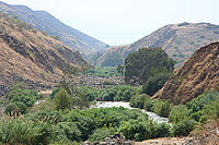
From the Sea of Galilee (the point at which the main tributaries join together), the river's plain spreads to a width of approximately 15 miles (24 km). This area of terraces is known as the Ghawr (or Ghar) and is cut by wadis or rivers into towers, pinnacles and badlands. These form a maze of ravines alternating with sharp crests and rises.
From this point, Jordan's floodplain, the Zur sees a widely winding course, which accounts for the excessive lenght of the river flow in comparison to the area it traverses to reach the Dead Sea. Dams were built along the river in the Zur region, turning the former thickets of reeds, tamarisk, willows, and white poplars into irrigated fields. After flowing through the Zur, the Jordan drains into the Dead Sea through a broad, gently sloping delta.
Tributaries
The tributaries of the Jordan are:
- The Hasbani River, which flows from Lebanon.
- The Baniyas River, which rises from a spring at Banias at the foot of Mount Hermon.
- The Dan River, whose source is also at the base of Mount Hermon.
- The Ayoun River, which flows from Lebanon.
- The Yarmouk River, which begins near the Golan Heights and flows to the Jordan River.
- The Harod River, which joins on the right bank of the Sea of Galilee.
- The Yabis River, from the left bank of the Sea of Galilee.
Geography
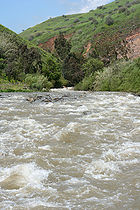
The Jordan River is shallow, with its high-water period lasting from January to March, while its low-water period occurs at the end of summer and the beginning of autumn. Its current is swift, carrying a heavy load of silt. It is unnavigable due to its precipitous upper course, its seasonal flow, and its shallow, twisting lower course.
The River's high degree of salinity is due to the existance of thermal springs, mainly in the Tiberias region on the western side of the Sea of Galilee. There is also a high concentration of gypsum. Irrigation waters often leave a salt residue in the soil.
In modern times the waters are 70 to 90 percent used for human purposes and the flow is much reduced. Because of this and the high evaporation rate of the Dead Sea, the sea is shrinking. All the shallow waters of the southern end of the sea have been drained in modern times and are now salt flats.
The waters of the Jordan are an extremely important resource to the dry lands of the area and have been a source of conflict between Lebanon, Syria, Jordan, Israel and the Palestine.
The River Valley
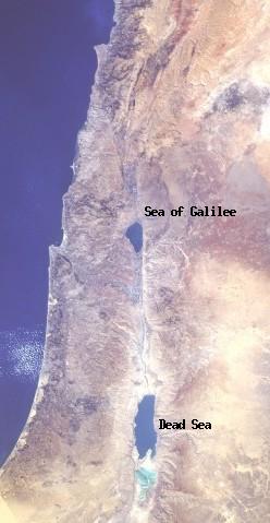
The Jordan Valley runs north — south, forming part of the Great Rift Valley which extends 4,000 miles from northern Syria to central Mozambique in East Africa. The Jordan Valley itself is long and narrow, averaging only 6 miles (10 km) in width. It is much lower than its surrounding landscape, with steep, sheer, bare walls.
The Hula Valley receives approximately 22 inches (550 mm) of rainfall per year, but only about 3 inches (75 mm) fall north of the Dead Sea. The Jordan Valley is fed by rains falling on the neighboring plateaus, through the wadi system which flow through the valley.
Environmental concerns
In 1964 Israel began operating a dam that diverts water from the Sea of Galilee, a major Jordan River water provider, to the national water carrier. In the same year, Jordan constructed a channel that diverted water from the Yarmouk River, another main tributary of the Jordan River. These acts resulted in great damage to the ecosystem.
Syria has also built reservoirs that catch the Yarmouk's waters. It is feared that Yarmouk's flow into the Jordan River could dwindle to a trickle, when a dam built jointly by Syria and Jordan begins operating.
Environmentalists blame Israel, Jordan and Syria for the loss of freshwater foliage that once flourished along the river's banks. It has been replaced with saline vegetation due to the three countries replenishment of the river with sewage water, agricultural runoff and salt water,
Biblical Reference
In the Hebrew Bible, the Jordan is referred to as the source of fertility to a large plain ("Kikkar ha-Yarden"), called on account of its luxuriant vegetation "the garden of God" (Genesis 13:10).
The Bible offers scattered and indefinite references to the Jordan River. Jacob crossed it and its tributary, the Jabbok, in order to reach Haran (Gen. 32:11, 23-24). It is noted as the line of demarcation between the "two tribes and the half tribe" settled to the east (Numbers 34:15) and the "nine tribes and the half tribe of Manasseh" that, led by Joshua, settled to the west (Josh. 13:7).
Opposite Jericho it was called "the Jordan of Jericho" (Num. 34: 15, 35: 1). The Jordan has a number of ford crossings, one of which is famous as the place where many Ephraimites were slain by Jephthah (Judges 12:5-6). It seems that these are the same fords mentioned as being near Beth-barah, where Gideon lay in wait for the Midianites (Judges 7:24). In the plain of the Jordan, between Succoth and Zarthan, is the clay ground where Solomon's brass foundries were located (I Kings 7:46).
In Biblical history the Jordan appears as the scene of several miracles, the first taking place when the Jordan, near Jericho, was crossed by the Israelites under Joshua (Josh. iii. 15-17). Later the two tribes and the half tribe that settled east of the Jordan built a large altar on its banks as "a witness" between them and the other tribes (Josh. xxii. 10, 26 et seq.). The Jordan was said to be crossed dry-shod by Elijah and Elisha (II Kings 2: 8, 14). Elisha performed two other miracles at the Jordan: he healed Naaman by having him bathe in its waters, and he made the ax of one of the children of the prophets float, by throwing a piece of wood into the water (II Kings 5:14, 6:6).
The Jordan was crossed by Judas Maccabeus and his brother Jonathan Maccabaeus during their war with the Nabatæans (1 Maccabees 5:24). Soon after, the Jordan was the scene of the battle between Jonathan and Bacchides, in which the latter was defeated (I Macc. 9:42-49).
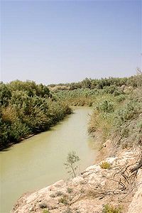
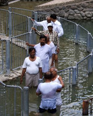
The New Testament states that John the Baptist baptized Jesus in the Jordan (Matt. 3:13).
Symbolic importance
The Jordan is a frequent symbol in folk, gospel, and spiritual music, or in poetic or literary works.
Because the Israelites made a difficult and hazardous journey from slavery in Egypt to freedom in The Promised Land, the Jordan can refer to freedom. The actual crossing is the final step of the journey, which is then complete. The Jordan also can signify death itself, with the crossing from life into Paradise or Heaven.
Images to be moved later
Notes
Sources and Further Reading
- Grunfeld, Lilach. 1997. Jordan River Dispute, Retrieved June 25, 2007.
- Trobaugh, Augusta. 2004. River Jordan: a novel. New York: Dutton. ISBN 0525947558 and ISBN 9780525947554
- Parry, Owen. 2001. Call each river Jordan. New York: William Morrow. ISBN 0060186380 and ISBN 9780060186388
- Hay, Ralph L., and Mike Meriwether. 2004. Jordan River assessment. Lansing, MI: Michigan Dept. of Natural Resources, Fisheries Division.
- Glueck, Nelson. 1946. The river Jordan, being an illustrated account of earth's most storied river. Philadelphia: Westminster Press.
- Stevens, Georgiana G. 1965. Jordan River partition. Hoover Institution studies, 6. [Stanford, Calif.]: Hoover Institution on War, Revolution, and Peace, Stanford University.
- Encyclopædia Britannica. 2007. Jordan River, Encyclopædia Britannica Online. Retrieved June 25, 2007.
External Links
- Bibliography on Water Resources and International Law. Peace Palace Library. Retrieved May 24, 2007.
- Integrated Water Resources Management in the Lower Jordan Rift Valley. Smart. Retrieved May 24, 2007.
- Plushnick-Masti, Ramit. September 11, 2006. Raw Sewage Taints Sacred Jordan River. Live Science. Retrieved May 24, 2007.
Credits
New World Encyclopedia writers and editors rewrote and completed the Wikipedia article in accordance with New World Encyclopedia standards. This article abides by terms of the Creative Commons CC-by-sa 3.0 License (CC-by-sa), which may be used and disseminated with proper attribution. Credit is due under the terms of this license that can reference both the New World Encyclopedia contributors and the selfless volunteer contributors of the Wikimedia Foundation. To cite this article click here for a list of acceptable citing formats.The history of earlier contributions by wikipedians is accessible to researchers here:
The history of this article since it was imported to New World Encyclopedia:
Note: Some restrictions may apply to use of individual images which are separately licensed.
