Difference between revisions of "Hallasan" - New World Encyclopedia
({{Contracted}}) |
Anne Inoue (talk | contribs) (japanese images) |
||
| Line 33: | Line 33: | ||
==Geology and geography== | ==Geology and geography== | ||
Hallasan is a massive [[shield volcano]] which forms the bulk of [[Jeju Island]] and is often taken as representing the island itself. There is a local saying stating that "Jeju Island is Hallasan; and Hallasan is Jeju." The mountain can indeed be seen from all places on the island, but its peak is often covered in clouds. The mountain has been designated Korea's [[Natural monuments of South Korea |Natural Monument]] no. 182. | Hallasan is a massive [[shield volcano]] which forms the bulk of [[Jeju Island]] and is often taken as representing the island itself. There is a local saying stating that "Jeju Island is Hallasan; and Hallasan is Jeju." The mountain can indeed be seen from all places on the island, but its peak is often covered in clouds. The mountain has been designated Korea's [[Natural monuments of South Korea |Natural Monument]] no. 182. | ||
| − | + | [[Image:Hallasan-2005_07_22_-_1.jpg|thumb|from Japanese wiki]] | |
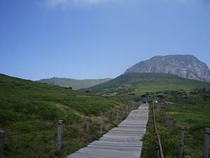
| + | [[Image:Hallasan-2005 07 22 - 1.jpg|thumb|300px|漢拏山山腳登山步道]] | ||
The volcanic island was constucted starting in the [[Pliocene]] epoch atop the [[continental shelf]], which is presently about 100 m (300 ft) below sea level in that area. Eruptions of [[basalt]] and [[trachyte]] [[lava]] built the island above sea level, and it now reaches a height of {{Unit m|1950|0}}. A large [[volcanic crater]] over {{Unit m|400|-2}} in diameter tops the volcano. About 360 [[parasitic cone]]s are found on the volcano's flanks, mostly [[cinder cone]]s and [[scoria cone]]s but also including some [[lava dome]]s and about 20 [[tuff ring]]s near the coast and offshore, which were formed by underwater [[phreatic eruption]]s. The most recent eruptions occurred on the flanks in [[1002]] and [[1007]]. | The volcanic island was constucted starting in the [[Pliocene]] epoch atop the [[continental shelf]], which is presently about 100 m (300 ft) below sea level in that area. Eruptions of [[basalt]] and [[trachyte]] [[lava]] built the island above sea level, and it now reaches a height of {{Unit m|1950|0}}. A large [[volcanic crater]] over {{Unit m|400|-2}} in diameter tops the volcano. About 360 [[parasitic cone]]s are found on the volcano's flanks, mostly [[cinder cone]]s and [[scoria cone]]s but also including some [[lava dome]]s and about 20 [[tuff ring]]s near the coast and offshore, which were formed by underwater [[phreatic eruption]]s. The most recent eruptions occurred on the flanks in [[1002]] and [[1007]]. | ||
Revision as of 17:09, 1 November 2007
| Hallasan | |
|---|---|
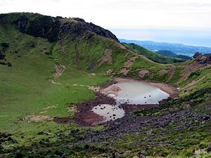
 Crater lakes on Hallasan. | |
| Elevation | 1,950 m (6,398 ft) |
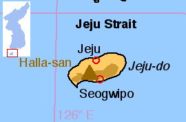
| Location | Jeju, South Korea |
| Prominence | 1,950 m (6,398 ft) |
| Geographic coordinates | 33°22′N 126°32′E |
| Type | Shield volcano |
| Last eruption | 1007 |
| Easiest Climbing route | trails, helicopter |
Hallasan (한라산) is a shield volcano on Jeju Island of South Korea. Hallasan is the highest mountain of South Korea. The area around the mountain is a designated national park, the Hallasan National Park (Hallasan Gungnip Gongwon/한라산국립공원/漢拏山國立公園). Hallasan is commonly considered to be one of the three main mountains of South Korea, with Jirisan and Seoraksan being the other two.
Names
Alternate names for the mountain include Halla Mountain or Mount Halla and older English sources refer to the peak as Mount Auckland.[1][2] Hallasan is written in North Korea in Hangul as if it were Hannasan (한나산); however, it is still pronounced as Hallasan. In the past, Hallasan has been known by numerous other names in Korean including Buag (부악/釜岳), Weonsan (원산/圓山), Jinsan (진산/鎭山), Seonsan (선산/仙山), Dumuag (두무악/頭無岳), Burasan (부라산/浮羅山), Yeongjusan 영주산(瀛州山), and Hyeolmangbong (혈망봉/穴望峯).[3]
| Hallasan | ||||||||
|---|---|---|---|---|---|---|---|---|
|
Geology and geography
Hallasan is a massive shield volcano which forms the bulk of Jeju Island and is often taken as representing the island itself. There is a local saying stating that "Jeju Island is Hallasan; and Hallasan is Jeju." The mountain can indeed be seen from all places on the island, but its peak is often covered in clouds. The mountain has been designated Korea's Natural Monument no. 182.
The volcanic island was constucted starting in the Pliocene epoch atop the continental shelf, which is presently about 100 m (300 ft) below sea level in that area. Eruptions of basalt and trachyte lava built the island above sea level, and it now reaches a height of 1,950 m (6,398 ft). A large volcanic crater over 400 m (1,300 ft) in diameter tops the volcano. About 360 parasitic cones are found on the volcano's flanks, mostly cinder cones and scoria cones but also including some lava domes and about 20 tuff rings near the coast and offshore, which were formed by underwater phreatic eruptions. The most recent eruptions occurred on the flanks in 1002 and 1007.
There is a crater lake on Hallasan called Baengnokdam (백록담/白鹿潭), literally "white deer lake." There is a legend attributing the name of the lake to otherworldly men who descend from heaven to play with white deer. Depending on the season, the circumference of the lake is up to 2 kilometres with a depth up to about 100 metres.
Sights
The mountain is home to Gwaneumsa, the oldest Buddhist temple on the island. The temple was originally built during the Goryeo Dynasty. Like many other temples in Korea, Gwaneumsa was destroyed and rebuilt in the 20th century. There is a memorial site outside the temple, remembering the victims of the Jeju uprising that took place between 1948 and 1950. It is one of the most visited places of the island.
Trails
There are four hiking trails to the top of Hallasan:
- Kwanumsa Trail - 8.3 km
- Orimok Trail - 7.8 km
- Songp'anak Trail - 9.6 km
- Yongshil Trail - 6.5 km
Notes
- ↑ Simon Winchester. Korea: a walk through the land of miracles (London, Penguin, 2004). Page 39.
- ↑ Simon Winchester (21 February 1988). "Social Climbing on Mount Halla". New York Times. Retrieved 2007-01-20.
- ↑ Hallasan National Park 한라산국립공원. Retrieved 2007-01-20.(Korean)
ReferencesISBN links support NWE through referral fees
Credits
New World Encyclopedia writers and editors rewrote and completed the Wikipedia article in accordance with New World Encyclopedia standards. This article abides by terms of the Creative Commons CC-by-sa 3.0 License (CC-by-sa), which may be used and disseminated with proper attribution. Credit is due under the terms of this license that can reference both the New World Encyclopedia contributors and the selfless volunteer contributors of the Wikimedia Foundation. To cite this article click here for a list of acceptable citing formats.The history of earlier contributions by wikipedians is accessible to researchers here:
The history of this article since it was imported to New World Encyclopedia:
Note: Some restrictions may apply to use of individual images which are separately licensed.

