Difference between revisions of "Bering Strait" - New World Encyclopedia
John Willis (talk | contribs) (added Status tag) |
(maybe longer) |
||
| Line 11: | Line 11: | ||
Suggestions have been made for the construction of a [[bridge]] spanning the Bering Strait between [[Alaska]] and [[Siberia]], dubbed by some the [[Intercontinental Peace Bridge]], and, alternatively, for a connecting [[tunnel]] underneath the strait. | Suggestions have been made for the construction of a [[bridge]] spanning the Bering Strait between [[Alaska]] and [[Siberia]], dubbed by some the [[Intercontinental Peace Bridge]], and, alternatively, for a connecting [[tunnel]] underneath the strait. | ||
| − | During the [[ice age]]s, the area of the strait was a [[land bridge]] known as the [[Bering land bridge]]. | + | During the [[ice age]]s, and perhaps for centuries after, the area of the strait was a [[land bridge]] known as the [[Bering land bridge]]. |
| − | |||
| − | |||
| − | |||
| − | |||
| − | |||
| − | |||
| − | |||
| − | |||
| − | |||
| − | |||
| − | |||
| − | |||
| − | |||
| − | |||
| − | |||
| − | |||
| − | |||
| − | |||
| − | |||
| − | |||
| − | |||
| − | |||
| − | |||
| − | |||
| − | |||
| − | |||
{{credit|23987553}} | {{credit|23987553}} | ||
Revision as of 00:24, 23 February 2006
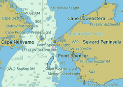
The Bering Strait is a sea strait between Cape Dezhnev, the eastmost point of the Asian continent and Cape Prince of Wales, the westernmost point of the American continent, approximately 85 km (58 mi) in width, with a depth of 30–50 m (100–165 ft). The strait connects the Chukchi Sea (part of the Arctic Ocean) in the north with the Bering Sea (part of the Pacific Ocean) in the south. It is named for Vitus Bering, a Danish-born Russian explorer who crossed the strait in 1728.
The Diomede Islands lie directly in the middle of the Bering Strait.
Suggestions have been made for the construction of a bridge spanning the Bering Strait between Alaska and Siberia, dubbed by some the Intercontinental Peace Bridge, and, alternatively, for a connecting tunnel underneath the strait.
During the ice ages, and perhaps for centuries after, the area of the strait was a land bridge known as the Bering land bridge.
Credits
New World Encyclopedia writers and editors rewrote and completed the Wikipedia article in accordance with New World Encyclopedia standards. This article abides by terms of the Creative Commons CC-by-sa 3.0 License (CC-by-sa), which may be used and disseminated with proper attribution. Credit is due under the terms of this license that can reference both the New World Encyclopedia contributors and the selfless volunteer contributors of the Wikimedia Foundation. To cite this article click here for a list of acceptable citing formats.The history of earlier contributions by wikipedians is accessible to researchers here:
The history of this article since it was imported to New World Encyclopedia:
Note: Some restrictions may apply to use of individual images which are separately licensed.

