Difference between revisions of "Bamako" - New World Encyclopedia
Mike Butler (talk | contribs) |
Mike Butler (talk | contribs) |
||
| Line 109: | Line 109: | ||
}} <!-- Infobox ends —> | }} <!-- Infobox ends —> | ||
| − | '''Bamako''', population 1,690,471 ([[2006]]), is the [[capital]] and largest city of [[Mali]], and currently estimated to be the fastest growing city in Africa (6th fastest in the world)<ref>[http://www.citymayors.com/statistics/urban_growth1.html World's fastest growing cities and urban areas from 2006 to 2020], by [[CityMayors.com]]</ref>. Bamako is the nation's administrative center, with a [[river port]] located in nearby [[Koulikoro]], and a major regional trade and conference center. Bamako is the 7th largest West African urban center after [[Lagos]], [[Abidjan]], [[Kano]], [[Ibadan]], [[Dakar]] and [[Accra]]. Bamako is located at {{coor dm|12|39|N|8|0|W|}}.<ref>[http://earth-info.nga.mil/gns/html/cntry_files.html GEOnet Names Server (GNS)], by the [[National Geospatial-Intelligence Agency]] | + | '''Bamako''', population 1,690,471 ([[2006]]), is the [[capital]] and largest city of [[Mali]], and currently estimated to be the fastest growing city in Africa (6th fastest in the world)<ref>[http://www.citymayors.com/statistics/urban_growth1.html World's fastest growing cities and urban areas from 2006 to 2020], by [[CityMayors.com]]</ref>. Bamako is the nation's administrative center, with a [[river port]] located in nearby [[Koulikoro]], and a major regional trade and conference center. Bamako is the 7th largest West African urban center after [[Lagos]], [[Abidjan]], [[Kano]], [[Ibadan]], [[Dakar]] and [[Accra]]. Bamako is located at {{coor dm|12|39|N|8|0|W|}}.<ref>[http://earth-info.nga.mil/gns/html/cntry_files.html GEOnet Names Server (GNS)], by the [[National Geospatial-Intelligence Agency]]</ref> |
==Geography== | ==Geography== | ||
| − | + | The name ''Bamako'' comes from the Bambara word meaning "[[crocodile]]'s back". | |
It is located on the [[Niger River]], near the rapids that divide the Upper and Middle Niger Valleys, in the southwestern part of the country. Bamako is relatively flat, except to the immediate north where there is an [[escarpment]], being what remains of an extinct volcano. | It is located on the [[Niger River]], near the rapids that divide the Upper and Middle Niger Valleys, in the southwestern part of the country. Bamako is relatively flat, except to the immediate north where there is an [[escarpment]], being what remains of an extinct volcano. | ||
Revision as of 19:58, 22 July 2008
| Bamako, Mali | |
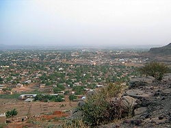
| View of Bamako | |
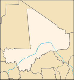
| Bamako within Mali | |
| Coordinates: 12°39′N 8°0′W | |
|---|---|
| Country | Mali |
| District | Bamako |
| Population (2006) | |
| - Total | 1,690,471 |
Bamako, population 1,690,471 (2006), is the capital and largest city of Mali, and currently estimated to be the fastest growing city in Africa (6th fastest in the world)[1]. Bamako is the nation's administrative center, with a river port located in nearby Koulikoro, and a major regional trade and conference center. Bamako is the 7th largest West African urban center after Lagos, Abidjan, Kano, Ibadan, Dakar and Accra. Bamako is located at 12°39′N 8°0′W.[2]
Geography
The name Bamako comes from the Bambara word meaning "crocodile's back".
It is located on the Niger River, near the rapids that divide the Upper and Middle Niger Valleys, in the southwestern part of the country. Bamako is relatively flat, except to the immediate north where there is an escarpment, being what remains of an extinct volcano.
Niger River tributaries which affect development in the city and the city is on a flood plain, so much of the land bordering the river can not be used for construction. The Presidential Palace and main hospital are located here.
Climate (not required unless it makes the city a resort)
Rivers and canals
Size – land area, size comparison
Environmental issues
Districts
History
The area of the city has been continuously inhabited since the Palaeolithic, but the founding of Bamako occurred in the seventeenth century by Seribadian Niaré and Soumba Coulibaly, or Bamba Sanogo, before its chiefdom passed to Diaoussadian Niaré. The city was an important market town. In 1883 the region was occupied by French troops, and in 1908, Bamako became the capital of the French Sudan. Its population has grown rapidly; in 1960 Bamako's population was approximately 160,000.
Layout of the city
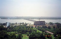
Originally, the city developed on the northern side of the river, but as it grew, bridges were developed to connect the north with the south. The first of these was the Pont des Martyrs (2-lane with 2 pedestrian sections) and the King Fahd Bridge (4-lane with 2 motorcycle and 2 pedestrian sections). Additionally, there is an older submersible bridge between the eastern neighborhoods of Sotuba and Misabugu inherited from colonial times (alternated traffic on 1-lane with 5 crossing sections). It is called "Chaussée submersible de Sotuba" in French, and "Babilikoroni" in Bamanankan, and is typically under water from July to January. A third bridge (1.4 km long, 24 m large, 4-lane with 2 motorcycle and 2 pedestrian sections) is being built by at the same location [3] to reduce downtown congestion, notably by trucks.
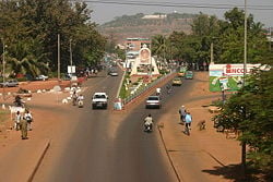
The traditional commercial centre of Bamako is to the north of the river, and contained within a triangle bounded by Avenue du Fleuve, Rue Baba Diarra and Boulevard du Peuple. This area contains the Marché Rose and Street Market. The downtown area is highly congested, polluted, and expensive, and urbanization is sprawling at a rapid pace within a radius of 30 km. The largest urbanized area now lies on the southern bank of the Niger River. A modern Central Business District is rapidly developing immediately west of the downtown area in the ACI-2000 district, taking advantage of a well-designed geometric layout, legacy of the old airport runways and taxiways. A large Administrative City is being developed at the junction between ACI-2000 and the King Fadh Bridge, purportedly to host most state departments (ministries) and administrative services in a central location.
Neighborhoods
- ACI-2000
- Badalabugu, Bajalan I, Bajalan II, Bako Jikoroni, Bagadaji, Bamako Kura, Bankoni, Bolibana, Bozola, Bugudani, Bulkasumbugu
- Dar Salam, Dawdabugu, Dravela
- Fajigila, Falaje
- Garantigibugu
- Jalakoroji (bordering Bamako District), Janekela, Janjigila, Jelibugu, Jikoroni Para, Jumanzana
- Hamdallaye, Hippodrome
- Kalaban Koro (bordering Bamako District), Kalaban Kura, Korofina, Kuluba, Kulubleni
- Lafiabugu
- Madina Kura, Misabugu, Misira
- Niarela, Ntomikorobugu
- Point G
- Quartier du Fleuve, Quartier Mali, Quinzanbugu
- Sabalibugu I, Sabalibugu II, Safo (bordering Bamako District), Same, Sangarebugu (bordering Bamako District), Saranbugu (bordering Bamako District), Sebeninkoro, Sikoroni, Sirakoro, Senu, Sibiribugu, Sokoroji, Sotuba
- Titibugu (bordering Bamako District), Torokorobugu, TSF-Sans Fil
- Wolofobugu
- Yirimanjo
- Zone Industrielle
Government
Economy
Manufactures include textiles, processed meat and metal goods. There is commercial fishing on the Niger River.
Demographics
Of interest
Notable landmarks in Bamako include the National Library of Mali, Tour BCEAO, Bamako Grand Mosque, Cathedral of Bamako and the King Fahd Bridge. It is home to Mali's largest international airport, Senou International Airport, as well as the Dakar-Niger Railway, to Koulikoro in eastern Mali and Dakar in Senegal. Attractions include the Mali National Museum, the Muso Kunda Museum, the Bamako Regional Museum, Bamako Zoo, the Bamako Botanical Gardens and the Point G hill, containing caves with rock paintings. Bamako has hosted the biannual photography festival African Photography Encounters since 1994.
In 1988, Bamako was the location of a WHO conference known as the Bamako Initiative that helped reshape health policy of Sub-Saharan Africa.
The yearly held Budapest-Bamako rally has the endpoint in Bamako, with the Dakar Rally often passing through Bamako.
ReferencesISBN links support NWE through referral fees
- ↑ World's fastest growing cities and urban areas from 2006 to 2020, by CityMayors.com
- ↑ GEOnet Names Server (GNS), by the National Geospatial-Intelligence Agency
- ↑ Construction du 3e Pont de Bamako : Maliens et Chinois d'accord sur les aspects techniques du projet
External links
- Bamako-culture.org (French language)
- Bamako at Cités du Monde (French language)
- The Bamako Appeal
- Mali Music Scene article in the New York Times
- Music samples article in the New York times
- Drumming Videos Shot in Bamako
- Budapest-Bamako
- Pictures of Bamako
- The official website of Angers Tourist Information Centre
Credits
New World Encyclopedia writers and editors rewrote and completed the Wikipedia article in accordance with New World Encyclopedia standards. This article abides by terms of the Creative Commons CC-by-sa 3.0 License (CC-by-sa), which may be used and disseminated with proper attribution. Credit is due under the terms of this license that can reference both the New World Encyclopedia contributors and the selfless volunteer contributors of the Wikimedia Foundation. To cite this article click here for a list of acceptable citing formats.The history of earlier contributions by wikipedians is accessible to researchers here:
The history of this article since it was imported to New World Encyclopedia:
Note: Some restrictions may apply to use of individual images which are separately licensed.
