Arkansas River
The Arkansas River is a major tributary of the Mississippi River. The Arkansas generally flows to the east and southeast and traverses the U.S. states of Colorado, Kansas, Oklahoma, and Arkansas.
At 1,469 miles (2,364 km) it is the sixth longest river in the United States,[1] the second-longest tributary in the Mississippi-Missouri system, and the 45th longest river in the world. Its origin is in the Rocky Mountains in Lake County, Colorado, near Leadville, and its outlet is at Napoleon, Arkansas. The Arkansas River drainage basin covers nearly 195,000 sq mi (505,000 km²).[2] In terms of volume, the river is smaller than both the Missouri and Ohio Rivers, with a mean discharge of 8,460 ft³/s (240 m³/s).
Hydrography

The Arkansas has three distinct sections in its long path through central North America.
At its headwaters the Arkansas runs as a steep mountain torrent through the Rockies in its narrow valley, dropping 4,600 feet (1.4 km) in 120 miles (193 km). This section (including The Numbers, Brown's Canyon, and the Royal Gorge) sees extensive whitewater rafting in the spring and summer.
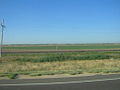
At Cañon City, Colorado, the Arkansas River valley widens and flattens markedly. Just west of Pueblo, Colorado, the river enters the Great Plains. Through the rest of Colorado, through Kansas, and through northern Oklahoma to Tulsa, it is a typical Great Plains riverway, with wide shallow banks subject to seasonal flooding. Tributaries include the Canadian River and the Cimarron River (both flowing from northeastern New Mexico) and the Salt Fork Arkansas River.
Below Tulsa, and continuing to its mouth, the river is navigable by barges and large river craft thanks to a series of dams that turn it into reservoirs. (Above Tulsa, it is navigable only by small craft such as rafts, canoes, and kayaks.)
Water flow in the Arkansas River (as measured in central Kansas) has dropped from approximately 248 cubic feet per second (7 m³/s) average from 1944-1963 to 53 cubic feet per second (1.5 m³/s) average from 1984-2003, largely because of the pumping of groundwater for irrigation in eastern Colorado and western Kansas.
Important cities along the Arkansas include Pueblo, Colorado; Wichita, Kansas; Tulsa, Oklahoma; Fort Smith and Little Rock, Arkansas.
The I-40 Bridge Disaster of May 2002 took place on I-40's crossing of Kerr Reservoir on the Arkansas River near Webbers Falls, Oklahoma.

Riverway commerce
The McClellan-Kerr Arkansas River Navigation System begins at the Tulsa Port of Catoosa on the Verdigris River, and runs via an extensive Lock and Dam system to the Mississippi River.
Through Oklahoma and Arkansas, dams artificially deepen and widen this modest sized river to build it into a commercially navigable body of water. From the mouth of the Verdigris until the McClellan-Kerr system moves over to the White River near Arkansas Post, the Arkansas sustains commercial barge traffic and offers passenger and recreational use and is little more than a series of reservoirs.
Watershed trails
Many nations of Native Americans lived near or along the Arkansas in its 1,450 mile (2334 km) stretch, but the first Europeans to see the river were members of the Coronado expedition on June 29, 1541. Also in the 1540s Hernando de Soto discovered the junction of the Arkansas with the Mississippi. The name "Arkansas" was first applied by Father Jacques Marquette, who called the river Akansa in his journal of 1673.
From 1819 the Adams-Onís Treaty set the Arkansas as part of the frontier between the United States and Spanish Mexico, which it remained until the annexation of Texas and Mexican-American War in 1846.
Later, the Santa Fe Trail followed the Arkansas through much of Kansas except for the Cimarron Cutoff from Cimarron, Kansas, to Cimarron, New Mexico, via Cimarron County, Oklahoma along the Cimarron River.
Angling
The Arkansas River, in central Colorado, provides some of the best brown trout fishing in the west.[citation needed] The first 150 miles of the river, from Leadville to Pueblo, is prime trout water. Conditions vary widely along this section so the river is broken up into 4 sections; Leadville to Buena Vista, Buena Vista to Salida, Salida to Canon City, Canon City to Pueblo. Seasons are quite different on each of these sections. The Arkansas through Canon City may be experiencing spring conditions, while the Leadville area is still under winter consitions. Because of this sudden change in climate and elevation, fishing conditions vary by section and time of year. Rainbow trout can also be caught.[3]
Pronunciations
Though many in the state of Kansas pronounce it as IPA: /ɑrˈkænzəz/, people in the state of Arkansas pronounce it /ˈɑrkənsɔː/ according to a state law passed in 1881[4]). People in the Southern United States pronounce it /ˈærkənsɔː/.
Gallery

Arkansas River passing through Wichita, Kansas
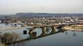
Arkansas River, looking across to North Little Rock
Drought can reduce the Arkansas River so much that trees along the river cannot survive.
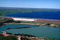
John Martin Dam and Reservoir on the Arkansas River in Bent County, Colorado
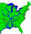
Inland waterway system with McClellan-Kerr Navigational Channel shown in red.
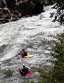
Whitewater kayaking on the Arkansas River

The Arkansas River in Tulsa, Oklahoma.
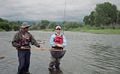
Fly Fishermen on the Arkansas River near Salida, Colorado
The Arkansas River in Natural Steps, Arkansas


See also
- List of crossings of the Arkansas River
- McClellan-Kerr Arkansas River Navigation System
- Listing of rivers for each state: Colorado, Kansas, Oklahoma, Arkansas
- Kansas v. Colorado
ReferencesISBN links support NWE through referral fees
- ↑ J.C. Kammerer (May 1990). "Largest Rivers in the United States". United States Geological Survey. Retrieved 2007-04-05.
- ↑ See watershed maps: 1
- ↑ Edrington, Bill (2003). Fly Fishing the Arkansas: An Angler's Guide and Journal. Xlibris Corporation. ISBN 141343522X.
- ↑ Stewart, George R. (1967). Names on the Land. Houghton Mifflin Company, pp. 335-340.
External links
- Aquifer saturation map for Equus Beds Aquifer Recharge Project
- Arkansas River Coalition
- Full Scale Map
- Wichita Water Center Tours
- Animated Map of navigation system
Credits
New World Encyclopedia writers and editors rewrote and completed the Wikipedia article in accordance with New World Encyclopedia standards. This article abides by terms of the Creative Commons CC-by-sa 3.0 License (CC-by-sa), which may be used and disseminated with proper attribution. Credit is due under the terms of this license that can reference both the New World Encyclopedia contributors and the selfless volunteer contributors of the Wikimedia Foundation. To cite this article click here for a list of acceptable citing formats.The history of earlier contributions by wikipedians is accessible to researchers here:
The history of this article since it was imported to New World Encyclopedia:
Note: Some restrictions may apply to use of individual images which are separately licensed.