Difference between revisions of "Mount Rainier" - New World Encyclopedia
(claimed for Dave Coryell) |
(added info and credit) |
||
| Line 17: | Line 17: | ||
|Easiest route = rock/ice climb via Disappointment Cleaver | |Easiest route = rock/ice climb via Disappointment Cleaver | ||
}} | }} | ||
| − | '''Mount Rainier''' is a [[stratovolcano]] in [[Pierce County, Washington]], located 54 miles (87 km) southeast of [[Seattle, Washington|Seattle]], [[Washington]], in the [[United States]]. It is a member in the [[Cascade Volcanic Belt]] and is the highest peak in the [[Cascade Range]], with a [[topographical summit]] of 14,411 feet (4,392 m). The mountain and the surrounding area comprise [[Mount Rainier National Park]]. With 26 major glaciers, Mount Rainier is the most heavily glaciated peak in the lower 48 states at 35 square miles of [[snow]] and [[glacier]]s. | + | '''Mount Rainier''' is a [[stratovolcano]] in [[Pierce County, Washington]], located 54 miles (87 km) southeast of [[Seattle, Washington|Seattle]], [[Washington]], in the [[United States]]. It is a member in the [[Cascade Volcanic Belt]] and is the highest peak in the [[Cascade Range]], with a [[topographical summit]] of 14,411 feet (4,392 m). The mountain and the surrounding area comprise [[Mount Rainier National Park]]. With 26 major glaciers, Mount Rainier is the most heavily glaciated peak in the lower 48 states at 35 square miles of [[snow]] and [[glacier]]s. It is also considered the most dangerous in the Cascade Volcanic Belt partially due to its steep slopes.[[Heat]] from the [[volcano]] keeps areas of the [[Volcanic crater|crater]] rim on its summit cone mostly free of snow and ice. The [[geothermal]] heat has also caused the formation of [[glacier caves]] in the twin summit craters. |
Mount Rainier was originally known as '''Talol''', '''Tahoma''', or '''Tacoma''', from the [[Puyallup (tribe)|Puyallup]] word ''təq{{IPA|ʷ}}ú{{IPA|ʔ}}bə{{IPA|ʔ}}'' ("mother of waters"). It has a [[topographic prominence]] of 13,211 feet (4,026 m), greater than that of [[K2]]. It is a prominent feature of the southern landscape in most of the [[Seattle]] metropolitan area. On clear days, it can also be seen from as far away as [[Portland, Oregon]], and [[Victoria, British Columbia]]. Because of its scenic dominance, Seattle-[[Tacoma, Washington|Tacoma]]-area residents often refer to it simply as "the Mountain." [http://www.ac.wwu.edu/~bgoebel/members/bbarcott.htm] | Mount Rainier was originally known as '''Talol''', '''Tahoma''', or '''Tacoma''', from the [[Puyallup (tribe)|Puyallup]] word ''təq{{IPA|ʷ}}ú{{IPA|ʔ}}bə{{IPA|ʔ}}'' ("mother of waters"). It has a [[topographic prominence]] of 13,211 feet (4,026 m), greater than that of [[K2]]. It is a prominent feature of the southern landscape in most of the [[Seattle]] metropolitan area. On clear days, it can also be seen from as far away as [[Portland, Oregon]], and [[Victoria, British Columbia]]. Because of its scenic dominance, Seattle-[[Tacoma, Washington|Tacoma]]-area residents often refer to it simply as "the Mountain." [http://www.ac.wwu.edu/~bgoebel/members/bbarcott.htm] | ||
| − | [[Mountain climbing]] on Mount Rainier is difficult; it includes climbing on the largest glaciers in the U.S. south of [[Alaska]]. Most climbers require two to three days to reach the summit. Climbing teams require experience in glacier travel, self-rescue, and wilderness travel. About 8,000 to 13,000 people attempt the climb each year [http://www.nps.gov/mora/climb/cl_stats.htm], about 90% via routes from Camp Muir on the southwest flank. Most of the rest | + | [[Mountain climbing]] on Mount Rainier is difficult; it includes climbing on the largest glaciers in the U.S. south of [[Alaska]]. Most climbers require two to three days to reach the summit. Climbing teams require experience in glacier travel, self-rescue, and wilderness travel. About 8,000 to 13,000 people attempt the climb each year, [http://www.nps.gov/mora/climb/cl_stats.htm], about 90% via routes from Camp Muir on the southwest flank. Most of the rest ascends [[Emmons Glacier]] are via Camp Schurman on the northeast. About half of the attempts are successful, with weather and conditioning being the most common reasons for failure. About three mountaineering deaths each year occur due to rock and ice fall, avalanche, falls, and hypothermia associated with severe weather. The weather is very volitile on the mountain and can be wet and cold anytime of the year. The coldest temperature recorded at Longmir was 9 degrees below zero. http://www.google.com/search?hl=en&rlz=1T4GGIC_enUS212US212&sa=X&oi=spell&resnum=0&ct=result&cd=1&q=Mt+Rainier+coldest+temperature+at+the+summit&spell=1 |
[[Hiking]], [[photography]], and [[camping]] are very popular in the park. There are several [[hiking trail]]s, including the [[Wonderland Trail]], a 93-mile circumnavigation of the peak. Mount Rainier is also popular for [[winter sports]], including [[snowshoe]]ing and [[cross-country skiing]]. | [[Hiking]], [[photography]], and [[camping]] are very popular in the park. There are several [[hiking trail]]s, including the [[Wonderland Trail]], a 93-mile circumnavigation of the peak. Mount Rainier is also popular for [[winter sports]], including [[snowshoe]]ing and [[cross-country skiing]]. | ||
| − | The [[Carbon River | + | The [[Carbon River]], Puyallup River, Nisqually River, and Cowlitz Rivers begin at eponymous glaciers of Mount Rainier. The sources of the White River in Washington state are Winthrop, Emmons, and Fryingpan Glaciers. The White and Carbon Rivers join the Puyallup River, which discharges into [[Commencement Bay]] at Tacoma, Washington. The Nisqually empties into [[Puget Sound]] east of Lacey, Washington|Lacey; and the Cowlitz joins the [[Columbia River]] between Kelso, Washington and Longview, Washington. |
==Geological history== | ==Geological history== | ||
| Line 32: | Line 32: | ||
[[Image:Mount-rainier-lahar-lavaflow-pyroclasticflow-hazardmap.jpg|left|thumb|Hazard map]] | [[Image:Mount-rainier-lahar-lavaflow-pyroclasticflow-hazardmap.jpg|left|thumb|Hazard map]] | ||
| − | In the past, Rainier has had large debris avalanches, and has also produced enormous [[lahar]]s ([[volcano|volcanic]] [[mudflow]]s) due to the large amount of glacial ice present. Its lahars have reached all the way to the [[Puget Sound]]. Around 5,000 years ago, a large chunk of the volcano slid away and that debris avalanche helped to produce the massive Osceola Mudflow, which went all the way to the site of present-day [[Tacoma, Washington|Tacoma]] and south Seattle. This massive avalanche of rock and ice took out the top 1,600 ft. (488 m) of Rainier, bringing its height down to around 14,400 ft. (4,389 m). About 530 to 550 years ago, the Electron Mudflow occurred, although this was not as large-scale as the Osceola Mudflow. | + | In the past, Rainier has had large debris avalanches, and has also produced enormous [[lahar]]s ([[volcano|volcanic]] [[mudflow]]s) due to the large amount of glacial ice present. Its lahars have reached all the way to the [[Puget Sound]]. In fact, much of the land east of Tacoma and south of Seattle is formed of prehistoric debris from Mt. Rainier.<ref>http:www.nps.gov/mora/</ref> Around 5,000 years ago, a large chunk of the volcano slid away and that debris avalanche helped to produce the massive Osceola Mudflow, which went all the way to the site of present-day [[Tacoma, Washington|Tacoma]] and south Seattle. This massive avalanche of rock and ice took out the top 1,600 ft. (488 m) of Rainier, bringing its height down to around 14,400 ft. (4,389 m). About 530 to 550 years ago, the Electron Mudflow occurred, although this was not as large-scale as the Osceola Mudflow. |
After the major collapse 5,000 years ago, subsequent eruptions of lava and tephra built up the modern summit cone until about as recently as 1,000 years ago. As many as 11 [[Holocene]] tephra layers have been found. | After the major collapse 5,000 years ago, subsequent eruptions of lava and tephra built up the modern summit cone until about as recently as 1,000 years ago. As many as 11 [[Holocene]] tephra layers have been found. | ||
Revision as of 22:59, 6 March 2007
- For other uses, see Mount Rainier (disambiguation).
| Mount Rainier | |||
|---|---|---|---|
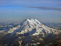
 Mount Rainier as viewed from the Sourdough Ridge trail. | |||
| Elevation | 14,410 ft (4,392 m) | ||
| Location | Washington State, USA | ||
| Mountain range | Cascades | ||
| Prominence | 13,211 ft (4,026 m) Ranked 21st | ||
| Geographic coordinates | {{#invoke:Coordinates|coord}}{{#coordinates:46|51|11.9|N|121|45|35.6|W|type:mountain_region:US | name=
}} | |
| Topographic map | USGS Mount Rainier West | ||
| Type | Stratovolcano | ||
| Geologic time scale | 500,000 years | ||
| Last eruption | 1854 | ||
| First ascent | 1870 by Hazard Stevens and P.B. Van Trump | ||
| Easiest Climbing route | rock/ice climb via Disappointment Cleaver | ||
Mount Rainier is a stratovolcano in Pierce County, Washington, located 54 miles (87 km) southeast of Seattle, Washington, in the United States. It is a member in the Cascade Volcanic Belt and is the highest peak in the Cascade Range, with a topographical summit of 14,411 feet (4,392 m). The mountain and the surrounding area comprise Mount Rainier National Park. With 26 major glaciers, Mount Rainier is the most heavily glaciated peak in the lower 48 states at 35 square miles of snow and glaciers. It is also considered the most dangerous in the Cascade Volcanic Belt partially due to its steep slopes.Heat from the volcano keeps areas of the crater rim on its summit cone mostly free of snow and ice. The geothermal heat has also caused the formation of glacier caves in the twin summit craters.
Mount Rainier was originally known as Talol, Tahoma, or Tacoma, from the Puyallup word təqʷúʔbəʔ ("mother of waters"). It has a topographic prominence of 13,211 feet (4,026 m), greater than that of K2. It is a prominent feature of the southern landscape in most of the Seattle metropolitan area. On clear days, it can also be seen from as far away as Portland, Oregon, and Victoria, British Columbia. Because of its scenic dominance, Seattle-Tacoma-area residents often refer to it simply as "the Mountain." [1]
Mountain climbing on Mount Rainier is difficult; it includes climbing on the largest glaciers in the U.S. south of Alaska. Most climbers require two to three days to reach the summit. Climbing teams require experience in glacier travel, self-rescue, and wilderness travel. About 8,000 to 13,000 people attempt the climb each year, [2], about 90% via routes from Camp Muir on the southwest flank. Most of the rest ascends Emmons Glacier are via Camp Schurman on the northeast. About half of the attempts are successful, with weather and conditioning being the most common reasons for failure. About three mountaineering deaths each year occur due to rock and ice fall, avalanche, falls, and hypothermia associated with severe weather. The weather is very volitile on the mountain and can be wet and cold anytime of the year. The coldest temperature recorded at Longmir was 9 degrees below zero. http://www.google.com/search?hl=en&rlz=1T4GGIC_enUS212US212&sa=X&oi=spell&resnum=0&ct=result&cd=1&q=Mt+Rainier+coldest+temperature+at+the+summit&spell=1
Hiking, photography, and camping are very popular in the park. There are several hiking trails, including the Wonderland Trail, a 93-mile circumnavigation of the peak. Mount Rainier is also popular for winter sports, including snowshoeing and cross-country skiing.
The Carbon River, Puyallup River, Nisqually River, and Cowlitz Rivers begin at eponymous glaciers of Mount Rainier. The sources of the White River in Washington state are Winthrop, Emmons, and Fryingpan Glaciers. The White and Carbon Rivers join the Puyallup River, which discharges into Commencement Bay at Tacoma, Washington. The Nisqually empties into Puget Sound east of Lacey, Washington|Lacey; and the Cowlitz joins the Columbia River between Kelso, Washington and Longview, Washington.
Geological history

Mount Rainier's earliest lavas are over 840,000 years old and are part of the Lily Formation (2.9 million to 840,000 years ago). The early lavas formed a "proto-Rainier" or an ancestral cone prior to the present-day cone. The present cone is over 500,000 years old (Sisson 1995). The volcano is highly eroded, with glaciers on its slopes, and appears to be made mostly of andesite. Rainier likely once stood even higher than today at 16,000 ft. (4,877 m) before a major debris avalanche and the resulting Osceola Mudflow 5,000 years ago.

In the past, Rainier has had large debris avalanches, and has also produced enormous lahars (volcanic mudflows) due to the large amount of glacial ice present. Its lahars have reached all the way to the Puget Sound. In fact, much of the land east of Tacoma and south of Seattle is formed of prehistoric debris from Mt. Rainier.[1] Around 5,000 years ago, a large chunk of the volcano slid away and that debris avalanche helped to produce the massive Osceola Mudflow, which went all the way to the site of present-day Tacoma and south Seattle. This massive avalanche of rock and ice took out the top 1,600 ft. (488 m) of Rainier, bringing its height down to around 14,400 ft. (4,389 m). About 530 to 550 years ago, the Electron Mudflow occurred, although this was not as large-scale as the Osceola Mudflow.
After the major collapse 5,000 years ago, subsequent eruptions of lava and tephra built up the modern summit cone until about as recently as 1,000 years ago. As many as 11 Holocene tephra layers have been found.
The most recent recorded volcanic eruption was between 1820 and 1854, but many eyewitnesses reported eruptive activity in 1858, 1870, 1879, 1882 and 1894 as well. As of 2002, there is no imminent risk of eruption, but geologists expect that the volcano will erupt again.
Lahars from Rainier pose the most risk to life and property, as many communities lie atop older lahar deposits. Not only is there much ice atop the volcano, the volcano is also slowly being weakened by hydrothermal activity. According to Geoff Clayton, a geologist with RH2, a repeat of the Osceola mudflow would destroy Enumclaw, Kent, Auburn, and most or all of Renton. Such a mudflow might also reach down the Duwamish estuary and destroy parts of downtown Seattle, and cause tsunamis in Puget Sound and Lake Washington.
Rainier is also capable of producing pyroclastic flows as well as lava.

Human history
Mount Rainier was first known by the Native Americans as Talol, Tahoma, or Tacoma, from the Puyallup word təqʷúʔbəʔ ("mother of waters"). At the time of European contact, the river valleys and other areas near the mountain were inhabited by many Pacific Northwest tribes who hunted and gathered berries in the forests and mountain meadows. These included the Nisqually, Cowlitz, Yakama, Puyallup, and Muckleshoot.
Captain George Vancouver reached Puget Sound in 1792 and became the first European to see the mountain. He named it in honour of his friend, Rear Admiral Peter Rainier.
In 1833, Dr. William Fraser Tolmie explored the area looking for medicinal plants. He was followed by other explorers seeking challenge. Hazard Stevens and P.B. Van Trump received a hero's welcome in the streets of Olympia after their successful summit climb in 1870. John Muir climbed Mount Rainier in 1888, and although he enjoyed the view, he conceded that it was best appreciated from below. Muir was one of many who advocated protecting the mountain. In 1893, the area was set aside as part of the Pacific Forest Reserve in order to protect its physical/economic resources: timber and watersheds.
Citing the need to also protect scenery and provide for public enjoyment, railroads and local businesses urged the creation of a national park in hopes of increased tourism. On March 2, 1899, President William McKinley established Mount Rainier National Park as America's fifth national park. Congress dedicated the new park "for the benefit and enjoyment of the people; and...for the preservation from injury or spoliation of all timber, mineral deposits, natural curiosities, or wonders within said park, and their retention in their natural condition."
In 1998, the United States Geological Survey began putting together the Mount Rainier Volcano Lahar Warning System to assist in the emergency evacuation of the Puyallup River valley in the event of a catastrophic debris flow. It is now run by the Pierce County Department of Emergency Management. Tacoma, at the mouth of the Puyallup, is only 37 miles (60 km) west of Rainier, and moderately sized towns such as Puyallup and Orting are only 27 and 20 miles (44 and 32 km) away, respectively.
Subsidiary peaks
The broad top of Mount Rainier contains three named summits. The highest is called Columbia Crest. The second highest summit is Point Success, 14,158 ft (4,315 m), at the southern edge of the summit plateau, atop the ridge known as Success Cleaver. It has a topographic prominence of about 138 ft (42 m), so it is not considered a separate mountain. The lowest of the three summits is Liberty Cap, 14,112 ft (4,301 m), at the northwestern edge, which overlooks Liberty Ridge, the Sunset Amphitheater, and the dramatic Willis Wall. Liberty Cap has a prominence of 492 ft (197 m), and so would qualify as a separate mountain under most strictly prominence-based rules.[2] However it is not usually considered a separate mountain, due to the massive size of Mount Rainier, relative to which a 492 foot drop is not very large.
High on the eastern flank of Mount Rainier is a peak known as Little Tahoma, 11,138 ft (3,395 m), a volcanic remnant of an earlier configuration of Mount Rainier. It has a prominence of 858 ft (262 m), and it is almost never climbed in direct conjunction with Columbia Crest, so it is usually considered a separate mountain.
The three summits of Mt. Rainier

Washington state quarter
The Washington state quarter, which will be released in March 2007, will feature Mount Rainier and a salmon. [3]
ReferencesISBN links support NWE through referral fees
- ↑ http:www.nps.gov/mora/
- ↑ A prominence cutoff of 400 feet is commonly used in Washington State. See The Northwest Peakbagger's Asylum.
- ↑ kolby. Washington State Quarter. Washington State Office of the Governor (2006-05-01). Retrieved 2007-02-22.
- Harris, Stephen L. (2005). "Mount Rainier: America's Most Dangerous Volcano", Fire Mountains of the West, 3rd edition, Missoula, Montana: Mountain Press Publishing Company, pp. 299-334. ISBN 0-87842-511-X.
- Parchman, F. The Super Flood, Seattle Weekly, Oct 19-25, 2005.
- Sisson, T.W., History and Hazards of Mount Rainier, Washington, USGS Open-File Report 95-642, (1995).
See also
- Mount Rainier National Park
- High Cascades
- Mount Baker
- Mount St. Helens
- Mount Adams
- Glacier Peak
- Mount Hood
- Mount Shasta
- Crater Lake
- Lassen Peak

External links
- Mount Rainier National Park (also used as a reference)
- Mount Rainer on TierraWiki.org
- USGS: Mount Rainier — Learning to Live with Volcanic Risk
- Mount Rainier Volcano Lahar Warning System
- Mount Rainier stream drainage
- Mount Rainier Trail Descriptions
- Mount Rainier on Peakbagger.com
- Mount Rainier on Bivouac.com
- Mount Rainier on SummitPost.org
- Photos of Mount Rainier National Park - Terra Galleria
- Time-lapse animation of Mt. Rainier Web Cam
- Virtual Tour of Mount Rainier in Washington
- Washington State Quarter
- University of Washington Libraries: Digital Collections:
- Lawrence Denny Lindsley Photographs Over 400 images representing the landscape and nature photography of Lawrence Denny Lindsley, including photographs of scenes around Mount Rainier and the Cascade Mountains, the Pacific Ocean beaches on the Olympic Peninsula, Eastern Washington and the Grand Coulee region.
- The Mountaineers Collection Photographic albums and text documenting the Mountaineers official annual outings undertaken by club members from 1907-1951, primarily on the Olympic Peninsula, in Mount Rainier National Park and on Glacier Peak. Includes 3 Mt. Rainier albums (ca. 1912, 1919, 1924).
- Henry M. Sarvant Photographs 212 photographs by Henry Mason Sarvant depicting his climbing expeditions to Mt. Rainier and scenes of the vicinity from 1892-1912.
- Alvin H. Waite Photographs Photographs of Mt. Rainier by Alvin H. Waite, one of Tacoma's most important landscape photographers during the late nineteenth and early twentieth centuries.
- Maps and aerial photos
- WikiSatellite view at WikiMapia
- Topographic map from TopoZone
- Surrounding area map from Google Maps
- Location in the United States from the Census Bureau
| Major Cascade Volcanoes | 
|
|---|---|
| Mount Silverthrone | Mount Meager | Mount Cayley | Mount Garibaldi | Mount Baker | Glacier Peak | Mount Rainier | Mount St. Helens | Mount Adams | Mount Hood | Mount Jefferson | Three Sisters | Newberry Volcano | Mount Mazama | Mount McLoughlin | Medicine Lake Volcano | Mount Shasta | Lassen Peak |
| U.S. State Highest Points |
|
|---|---|
| Alabama - Alaska - Arizona - Arkansas - California - Colorado - Connecticut - Delaware - Florida - Georgia - Hawaii - Idaho - Illinois - Indiana - Iowa - Kansas - Kentucky - Louisiana - Maine - Maryland - Massachusetts - Michigan - Minnesota - Mississippi - Missouri - Montana - Nebraska - Nevada - New Hampshire - New Jersey - New Mexico - New York - North Carolina - North Dakota - Ohio - Oklahoma - Oregon - Pennsylvania - Rhode Island - South Carolina - South Dakota - Tennessee - Texas - Utah - Vermont - Virginia - Washington - West Virginia - Wisconsin - Wyoming |
Credits
New World Encyclopedia writers and editors rewrote and completed the Wikipedia article in accordance with New World Encyclopedia standards. This article abides by terms of the Creative Commons CC-by-sa 3.0 License (CC-by-sa), which may be used and disseminated with proper attribution. Credit is due under the terms of this license that can reference both the New World Encyclopedia contributors and the selfless volunteer contributors of the Wikimedia Foundation. To cite this article click here for a list of acceptable citing formats.The history of earlier contributions by wikipedians is accessible to researchers here:
The history of this article since it was imported to New World Encyclopedia:
Note: Some restrictions may apply to use of individual images which are separately licensed.