Difference between revisions of "Los Glaciares National Park" - New World Encyclopedia
Vicki Phelps (talk | contribs) |
Vicki Phelps (talk | contribs) |
||
| Line 85: | Line 85: | ||
</gallery> | </gallery> | ||
==Looking to the future== | ==Looking to the future== | ||
| − | Guemal or Huemul occur in several national parks in Chile and neighboring parts of Argentina, including Los Glaciares National Park. They have been on the [[endangered species|endangered]] list since 1976, primarily due to human impacts such as [[deforestation]], habitat fragmentation by [[road]]s, introduction of non-native [[mammal]]s such as farm animals, and poaching. They are in a classic "extinction spiral" marked by increasingly small, isolated populations and are now considered critically endangered. | + | Guemal (or Huemul) occur in several national parks in [[Chile]] and neighboring parts of [[Argentina]], including Los Glaciares National Park. They have been on the [[endangered species|endangered]] list since 1976, primarily due to human impacts such as [[deforestation]], habitat fragmentation by [[road]]s, introduction of non-native [[mammal]]s such as farm animals, and poaching. They are in a classic "extinction spiral" marked by increasingly small, isolated populations and are now considered critically endangered. |
==Notes== | ==Notes== | ||
Revision as of 17:07, 23 February 2009
| Los Glaciares* | |
|---|---|
| UNESCO World Heritage Site | |
 | |
| State Party | |
| Type | Natural |
| Criteria | vii, viii |
| Reference | 145 |
| Region** | Latin America and the Caribbean |
| Inscription history | |
| Inscription | 1981 (5th Session) |
| * Name as inscribed on World Heritage List. ** Region as classified by UNESCO. | |
Parque Nacional Los Glaciares (Spanish: The Glaciers) is a national park in the Santa Cruz Province, in Argentine Patagonia. It comprises an area of 1,722 square miles (4,459 km²)[1]. In 1981 it was declared a World Heritage Site by UNESCO, which described it as "an area of exceptional natural beauty, with rugged, towering mountains and numerous glacial lakes."
The national park, created in 1937, is the second largest in Argentina. Its name refers to the giant ice cap in the Andes range that feeds 47 large glaciers, of which only 13 flow toward the Atlantic Ocean. The ice cap is the largest outside Antarctica and Greenland. In other parts of the world, glaciers start at a height of at least 2,500 meters above mean sea level (AMSL), but due to the size of the ice cap, these glaciers begin at only 1,500m, sliding down to 200m AMSL, eroding the surface of the mountains that support them.

| Los Glaciares National Park | |
|---|---|
| IUCN Category II (National Park) | |
 | |
| Location: | Santa Cruz Province, Argentina |
| Area: | 4459 km² |
| Established: | 1937 |
| Governing body: | Administración de Parques Nacionales |
Geography
Los Glaciares, 30 percent of which is covered by ice, can be divided in two regions: forests and grassy plains in the east and peaks, lakes, and glaciers in the west. Each corresponds with one of the two elongated lakes partially contained by the park. Lake Argentino, 1,466 km² and the largest in Argentina, is in the south, while Lake Viedma, 1,100 km², is in the north. Both lakes feed the Santa Cruz River that flows down to Puerto Santa Cruz on the Atlantic coast. Between the two halves is a non-touristic zone without lakes called Zona Centro.
The northern half consists of part of Viedma Lake, the Viedma Glacier and a few minor glaciers, and a number of mountains very popular among fans of climbing and trekking, including Mount Fitzroy, the highest point in the park at 11,073 feet (3,375 m), and Cerro Torre.
The southern part has, as well as a number of smaller ones, the major glaciers that flow into Lake Argentina: Perito Moreno Glacier, Upsala Glacier, and Spegazzini Glacier. Typical excursion boats travel between icebergs to visit Bahía Onelli and the otherwise inaccessible Spegazzini and Upsala. The Perito Moreno is reachable by land.
Glaciers
Perito Moreno, one of the largest glaciers in both the park and South America, has walls that rise over 200 feet (40 m) from where the ice meets the Lago Argentino, or Lake Argentina. It is noted for its dynamic and ever-changing facade. While most glaciers are receding, the Peritio Moreno formation is an "advancing glacier" whose ice is continually expanding outward, adding up to seven feet each day. On the other hand, as chunks of ice fall from the walls, the size shrinks. It can be viewed by foot or from a cruise boat.
The Upsala Glacier, located near the northern arm of Lago Argentino is 50 kilometers long, 10 kilometers wide, and hundreds of meters thick. Considered one of three major glaciers in the park, along with Perito Moreno and Spegazzini, the beauty of the Upsala glacier is renowned. It also possesses one of the most significant medial moraines in South America. A moraine is a collection of rock, sand, and clay deposits that has fallen from neighboring mountains and is transported by the slow movements of glacial ice sheets. Over time, these accumulations grow, marking the direction of glacial flow. A medial moraine appears when more than two glaciers unite and bring together debris from multiple sources.
The Spegazzini Glacier covers an area of 66 square kilometers and is 1.5 kilometers wide. It is outstanding mainly for its high and imposing walls. The front of the glacier reaches 135 meters.
Flora and fauna
The mountains hold most of the humidity from the Pacific Ocean, letting through only the icy coldness (annual average of 7.5 °C) and creating an arid steppe on the Argentine side of the range. This area is habitat for guanacos (a camelid animal native to the arid, mountainous regions of South America, cougars, chinchillas, pudu and guemal (two species of small deer), and gray foxes. Foxes have suffered from the invasion of the cattle industry and are endangered. The guanaco, while not endangered, has had a dramatic decline in its historic population due to large-scale grazing of livestock throughout much of Patagonia.
There are over a thousand species of birds in the area, including rheas (large, flightless birds with long legs and long necks, similar to an ostrich), condors, and eagles.
Approximately, 260,000 hectares are covered with ice and therefore have no vegetation; another 95,000 hectares are lakes. Forests cover about 79,000 hectares and the predominant species are lenga (beech) and guindo. The flora grows in three well-defined areas: steppe, forest, and highlands semi-desert. Those on the steppe present a high level of adaptation to very dry conditions and defense against cold and wind. The "gramineas," for example, grow in low and compact tufts, with folded [[leaf}leaves]], rigid and covered with thick cutine, which diminishes evaporation.
Lenga (Nothofagus pumilio) is a deciduous tree or shrub native to the southern Andes range. It grows in areas with low temperatures and abundant snow; it tolerates temperatures of −22°F(−30°C) and lower and frosts at all seasons of the year.
In between the upper Andean vegetation and the lakes the most important species are in the Nothofagus genus. The woods' upper boundary lies between 1,000 and 1,100 meters. There are three Nothofagus species in the park:
- Lenga (Nothofagus pumilio)
- Ñire (Nothofagus antárctica or Antarctic Beech)
- Coihue o guindo (Nothofagus betuloides)
Of these, the lenga is the most widely distributed and occupies the biggest proportion of the woods. They are found usually covered with Usnea, called "old man's beard" because it hangs in long ribbons hanging from the trees. The mountains around Lago Argentino are covered with dense woods.
Climate change
Greepeace reported in 2004 that the Patagonian ice fields had lost 42 cubic kilometers of ice every year for the previous seven years, a process that has accelerated in recent years. Currently the Patagonian ice fields contribute to 9 percent of the global sea level rise from mountain glaciers.[2]
The environmental activist group attributed the increased thinning to climate change, manifested in a pattern of higher air temperatures and decreased precipitation. It noted, however, that part of the answer can be found in the special dynamics of these glaciers, which are dominated by so-called calving glaciers. Such glaciers spawn icebergs into the ocean or lakes and have different dynamics from glaciers that end on land and melt at their front ends. Calving glaciers are more sensitive to climate change once pushed out of equilibrium.
Human use
Los Glaciares is a major attraction for international tourists. Starting points of tours are the village of El Calafate at the shore of Lake Argentina but outside the park, where the park's administration has its headquarters, and El Chaltén village in the northern part of the park, at the foot of Mount Fitzroy. Other touristic points in the park include Lago del Desierto and Lago Roca.
Activities for visitors include horseback riding, hiking, fishing, rafting, bike riding, and birdwatching.
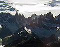
Aerial view of Cerro Torre (left) and Mount Fitz Roy
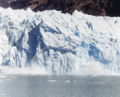
Part of the 100-meter wall of the Spegazzini glacier falling
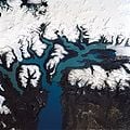
The national park as seen from space


Looking to the future
Guemal (or Huemul) occur in several national parks in Chile and neighboring parts of Argentina, including Los Glaciares National Park. They have been on the endangered list since 1976, primarily due to human impacts such as deforestation, habitat fragmentation by roads, introduction of non-native mammals such as farm animals, and poaching. They are in a classic "extinction spiral" marked by increasingly small, isolated populations and are now considered critically endangered.
Notes
- ↑ UNEP-WCMC Protected Areas Programme, Los Glaciares National Park
- ↑ [1] Greenpeace. Retrieved February 22, 2009
ReferencesISBN links support NWE through referral fees
- Alan Kearney. 1993. Mountaineering in Patagonia. Seattle. WA: Cloudcap.
External links
- Official site (English/Spanish)
- UNESCO World Heritage (English)
- Encyclopaedia Britannica, Los Glaciares National Park (English)
- Parque Nacional Los Glaciare (English)
- Fauna(Spanish)
- Paisaje Natural (Spanish)
- Photos Los Glaciares National Park (English)
Credits
New World Encyclopedia writers and editors rewrote and completed the Wikipedia article in accordance with New World Encyclopedia standards. This article abides by terms of the Creative Commons CC-by-sa 3.0 License (CC-by-sa), which may be used and disseminated with proper attribution. Credit is due under the terms of this license that can reference both the New World Encyclopedia contributors and the selfless volunteer contributors of the Wikimedia Foundation. To cite this article click here for a list of acceptable citing formats.The history of earlier contributions by wikipedians is accessible to researchers here:
The history of this article since it was imported to New World Encyclopedia:
Note: Some restrictions may apply to use of individual images which are separately licensed.