Difference between revisions of "Budapest" - New World Encyclopedia
Mike Butler (talk | contribs) |
Mike Butler (talk | contribs) |
||
| Line 41: | Line 41: | ||
==Geography== | ==Geography== | ||
[[Image:Budapest pest.jpg|thumb|left|250px|A view of Pest from the Buda side of the Danube]] | [[Image:Budapest pest.jpg|thumb|left|250px|A view of Pest from the Buda side of the Danube]] | ||
| − | + | [[Image:Budapest SPOT 1022.jpg|thumb|left|250px|Budapest seen from Spot Satellite]] | |
Budapest lies in central [[Hungary]]. [[Pest]] lies on the flat terrain of the Great Plain while [[Buda]] is rather hilly. Budapest covers an area of 203 square miles (525 square kilometers). | Budapest lies in central [[Hungary]]. [[Pest]] lies on the flat terrain of the Great Plain while [[Buda]] is rather hilly. Budapest covers an area of 203 square miles (525 square kilometers). | ||
| Line 53: | Line 53: | ||
The ornate Neo-Gothic Parliament Building faces Castle Hill on the Pest side of the river. The Inner Town, with streets laid out in an irregular pentagon, is the heart of Pest. It has offices, parts of the Loránd Eötvös University, and shops. The Inner Town Parish Church is Pest's oldest building. Andrássy Avenue, which runs straight from the centre of Pest to City Park (Városliget), which contains the Millennium Monument, is the finest thoroughfare in Budapest. | The ornate Neo-Gothic Parliament Building faces Castle Hill on the Pest side of the river. The Inner Town, with streets laid out in an irregular pentagon, is the heart of Pest. It has offices, parts of the Loránd Eötvös University, and shops. The Inner Town Parish Church is Pest's oldest building. Andrássy Avenue, which runs straight from the centre of Pest to City Park (Városliget), which contains the Millennium Monument, is the finest thoroughfare in Budapest. | ||
| − | + | ||
| + | Seven islands can be found on the Danube at Budapest: The are Hajógyári sziget (literal translation: Shipyard Island), [[Margit-sziget]] (Margaret Island), [[Csepel]] sziget, Palotai-sziget (a peninsula), Népsziget (connected to the above, but mostly surrounded by water), Háros-sziget and Molnár-sziget. The northernmost part of [[Csepel]] sziget is a district of Budapest. while the other islands are parts of other districts. | ||
| + | |||
{{wide image|BudapestPanorama2.JPG|998px|Left to right: Mária Magdolna Tower, Matthias Church, Castle Quarter, Széchenyi Chain Bridge, Margaret Island, Danube Promenade, Parliament Building, Hungarian Academy of Sciences.}} | {{wide image|BudapestPanorama2.JPG|998px|Left to right: Mária Magdolna Tower, Matthias Church, Castle Quarter, Széchenyi Chain Bridge, Margaret Island, Danube Promenade, Parliament Building, Hungarian Academy of Sciences.}} | ||
| Line 131: | Line 133: | ||
== Of interest == | == Of interest == | ||
| + | [[Image:Budapest Széchenyi fürdő.png|250px|right|thumb|Széchenyi Thermal Bath.]] | ||
[[Image:Liszt Academy.jpg|thumb|right|250px|The New Academy, facing Ferenc Liszt Square]] | [[Image:Liszt Academy.jpg|thumb|right|250px|The New Academy, facing Ferenc Liszt Square]] | ||
| − | |||
The neo-Gothic [[Hungarian Parliament Building|Parliament]], containing amongst other things the [[Holy Crown of Hungary|Hungarian Crown Jewels]]. | The neo-Gothic [[Hungarian Parliament Building|Parliament]], containing amongst other things the [[Holy Crown of Hungary|Hungarian Crown Jewels]]. | ||
[[Saint Stephen's Basilica]], where the Holy Right Hand of the founder of Hungary, [[King of Hungary|King]] [[Stephen I of Hungary|Saint Stephen]] is on display. | [[Saint Stephen's Basilica]], where the Holy Right Hand of the founder of Hungary, [[King of Hungary|King]] [[Stephen I of Hungary|Saint Stephen]] is on display. | ||
| Line 145: | Line 147: | ||
The city is home to the largest synagogue in Europe ([[Dohány Street Synagogue]])<ref>{{cite web|title=Out of Darkness, New Life|work=[[The New York Times]]|url=http://travel.nytimes.com/2007/12/30/travel/30dayout.html?scp=1&sq=largest+synagogue+in+Europe&st=nyt|date=2007-12-30|accessdate=2008-03-12}}</ref>, the largest medicinal bath in Europe ([[Széchenyi Medicinal Bath]]) and the third largest [[Hungarian Parliament Building|Parliament building]] in the world, once the largest in the world. The third largest church in Europe ([[Esztergom Basilica]]) and the second largest Baroque castle in the world ([[Gödöllő]]) are in the vicinity. | The city is home to the largest synagogue in Europe ([[Dohány Street Synagogue]])<ref>{{cite web|title=Out of Darkness, New Life|work=[[The New York Times]]|url=http://travel.nytimes.com/2007/12/30/travel/30dayout.html?scp=1&sq=largest+synagogue+in+Europe&st=nyt|date=2007-12-30|accessdate=2008-03-12}}</ref>, the largest medicinal bath in Europe ([[Széchenyi Medicinal Bath]]) and the third largest [[Hungarian Parliament Building|Parliament building]] in the world, once the largest in the world. The third largest church in Europe ([[Esztergom Basilica]]) and the second largest Baroque castle in the world ([[Gödöllő]]) are in the vicinity. | ||
| + | |||
| + | ==Gallery== | ||
<center> | <center> | ||
<gallery> | <gallery> | ||
| Line 161: | Line 165: | ||
</gallery> | </gallery> | ||
</center> | </center> | ||
| − | |||
| − | |||
| − | |||
| − | |||
| − | |||
| − | |||
| − | |||
| − | |||
| − | |||
| − | |||
| − | |||
| − | |||
==References== | ==References== | ||
Revision as of 21:41, 11 August 2008
| Budapest | |||
 |
|||
|
|||
| Nickname: "Pearl of the Danube" or "Queen of the Danube", "Heart of Europe", "Capital of Freedom" |
|||
 |
|||
| Coordinates: {{#invoke:Coordinates|coord}}{{#coordinates:47|28|19|N|19|03|01|E|type:city | |||
|---|---|---|---|
| name= }} | |||
| Country | Hungary | ||
| County | Budapest, Capital City | ||
| Government | |||
| - Mayor | Gábor Demszky (SZDSZ) | ||
| Area | |||
| - City | 525.16 km² (202.8 sq mi) | ||
| Population (2007) | |||
| - City | 1,696,128 | ||
| - Density | 3,232/km² (8,370.8/sq mi) | ||
| - Metro | 2,451,418 | ||
| Time zone | CET (UTC+1) | ||
| - Summer (DST) | CEST (UTC+2) | ||
| Website: budapest.hu | |||


Budapest (pronounced /ˈbu:dʌˌpɛʃt/ (AE), also /ˈbju:-/ (BE) or /ˈbʊ-/; Hungarian IPA: ['budɒpɛʃt]) is the capital city of Hungary. As the largest city, it serves as the country's principal political, cultural, commercial, industrial, and transportation center and is considered an important hub in Central Europe. Budapest became a single city occupying both banks of the river Danube with the unification on November 17, 1873, of right-bank (west) Buda and Óbuda (Old Buda) together with Pest on the left (east) bank. Budapest was the focal point of the Hungarian Revolution of 1848, the Hungarian Soviet Republic of 1919, Operation Panzerfaust in 1944, the Battle of Budapest of 1945, and the Revolution of 1956.
Widely regarded as one of the most beautiful cities in Europe, its World Heritage Sites include the banks of the Danube, the Buda Castle Quarter, Andrássy Avenue, and the Millennium Underground railway, the first on the European continent. Budapest attracts over 20 million visitors a year. The city ranks 52nd on MasterCard's 'World's Top 75 Financial Centers' list and 74th on Mercer Consulting's 'World's Top 100 Most Livable Cities' list. The headquarters of the European Institute of Innovation and Technology (EIT) will be in Budapest.
Geography

Budapest lies in central Hungary. Pest lies on the flat terrain of the Great Plain while Buda is rather hilly. Budapest covers an area of 203 square miles (525 square kilometers).
Budapest has a temperate, transitional climate - somewhere between the mild, rainy weather of Transdanubia and the variable climate of the flat and open Great Plain to the east. Temperatures in January average 30°F (-1°C) and in July 72°F (22°C). Winter snowfalls can be heavy, and the temperature may fall well below freezing. Heat waves plus humidity can make the summer oppressive. Mean annual precipitation is 24 inches (600mm).
The Danube enters the city from the north; later it encircles two islands, Óbuda Island and Margaret Island. The river that separates the two parts of the city is only 755 feet (230 meters) wide at its narrowest point in Budapest.
The Danube (which regularly flooded Pest before the river was controlled in the 19th century) has become heavily contaminated. Air pollution afflicts most districts in Pest.
Castle Hill, which is 551 feet (168 metres) above sea level and crowned by the restored Buda Castle, is in a central location. A steep limestone escarpment known as Gellért Hill overlooking the Danube lies south of Castle Hill, and has the Citadel, built in the 19th century. Rose Hill, which is to the north of Castle Hill, is where Hungary’s elite have houses. Margaret Island is a mile-long park with hotels and swimming pools.
The ornate Neo-Gothic Parliament Building faces Castle Hill on the Pest side of the river. The Inner Town, with streets laid out in an irregular pentagon, is the heart of Pest. It has offices, parts of the Loránd Eötvös University, and shops. The Inner Town Parish Church is Pest's oldest building. Andrássy Avenue, which runs straight from the centre of Pest to City Park (Városliget), which contains the Millennium Monument, is the finest thoroughfare in Budapest.
Seven islands can be found on the Danube at Budapest: The are Hajógyári sziget (literal translation: Shipyard Island), Margit-sziget (Margaret Island), Csepel sziget, Palotai-sziget (a peninsula), Népsziget (connected to the above, but mostly surrounded by water), Háros-sziget and Molnár-sziget. The northernmost part of Csepel sziget is a district of Budapest. while the other islands are parts of other districts.
History


The first town, built by Celts in the first century B.C.E., which occupied about 30 hectares along the slopes of Gellért Hill, was called "Ak Ink", meaning "spring rich in water". The town was occupied by the Romans at the beginning of the Christian era. In 106 C.E., the Roman settlement - Aquincum - became the main city of Lower Pannonia, with a population of about 20,000. The Romans constructed roads, amphitheaters, baths and houses with heated floors in this fortified military camp.
The Romans pulled out in the 5th century AD to be succeeded by the Huns through fierce battles. Germanic tribes, Lombards, Avars and Slavs all passed through during the second Age of Migrations (following the split up of the Hun tribe, after Attila the Hun died), until the arrival of the Magyars in about 896.
While other tribes spread across the entire Carpathian basin, the clan of Árpád settled down on Csepel sziget (Csepel Island), a very large island surrounded by the deep waters of the Danube, forming a good defensive shelter for the settlers who started agricultural works (south part of Budapest today). It was under the Árpád dynasty that Hungary became a Christian state, ruled first from Esztergom and later from Székesfehérvár.
The development of Buda and Pest's wide riverbanks did not really start until the 12th century, and was largely thanks to the French, Walloon and German settlers who migrated here and worked and traded along the banks of the Danube, there under royal protection. Both towns were devastated by the invading Mongols in 1241-42 and subsequently rebuilt by colonists from Germany, who re-named Buda "Ofen", after its numerous lime-kilns. (The "Pest" name, which has a Slav origin, also means "furnace".)
King Béla IV of Hungary (1206-1270) ordered the construction of reinforced stone walls around the towns and set his own royal palace on the top of the protecting hills of Buda. In 1361 it became the capital of Hungary
The cultural role of Buda was particularly significant during reign of Matthias Corvinus of Hungary (1458-1490). The Italian Renaissance had a great influence on the city. His library, the Bibliotheca Corviniana, was Europe's greatest collection of historical chronicles and philosophic and scientific works in the 15th century, and second only in size to the Vatican Library. After the foundation of the first Hungarian university in Pécs in 1367 the second one was established in Óbuda in 1395. The first Hungarian book was printed in Buda in 1473.
The Turkish occupation lasted for more than 140 years and left mainly destruction. The Turks constructed some fine bathing facilities here[1]. The western part of the country not occupied by the Turks became part of the Habsburg Empire as Royal Hungary. In 1686 Leopold I liberated Buda from the Ottomans but almost destroyed the city during the battle[2]. Hungary was then incorporated into the Habsburg Empire.
The nineteenth century was dominated by the Hungarian's struggle for independence and modernization. The national insurrection against the Habsburgs began in the Hungarian capital in 1848 and was defeated a little more than a year later.
In 1867, the Reconciliation that brought about the birth of Austria-Hungary. This made Budapest the twin capital of a dual monarchy. It was this compromise which opened the second great phase of development in the history of Budapest, lasting until World War I. In 1873 Buda and Pest were officially merged with the third part, Óbuda (Ancient Buda), thus creating the new metropolis of Budapest. Dynamic Pest grew into the country's administrative, political, economic, trade and cultural hub.
In 1910, 880,000 people occupied Budapest and 55,000 lived in the largest suburb of Újpest (now part of Budapest).
World War I brought the Golden Age to an end. In 1918 Austria-Hungary lost the war and collapsed; Hungary declared itself an independent republic. In 1920 the Treaty of Trianon finalized the country's partition, reducing Hungary's size by two-thirds and turning the multinational state into a nation-state.
On March 19, 1944, Budapest was occupied by the Germans. At the time of the occupation, there were 184,000 Jews and about 65,000-80,000 Christians considered Jewish in the town. Between 20 percent and 40 percent of Greater Budapest's 250,000 Jewish inhabitants died through Nazi and Arrow Cross genocide during 1944 and early 1945. Despite this, Budapest today has the highest number of Jewish citizens per capita of any European city.
In 1944, towards the end of World War II, Budapest was partly destroyed by British and American air raids. From 24 December, 1944 to 13 February 1945, the city was besieged during the Battle of Budapest. Budapest suffered major damage caused by the attacking Soviet troops and the defending German and Hungarian troops. All bridges were destroyed by the Germans. More than 38,000 civilians lost their lives during the fighting.
In 1949, Hungary was declared a communist People's Republic. The new Communist government considered the buildings like the Buda Castle symbols of the former regime, and during the 1950s the palace was gutted and all the interiors were destroyed.
In 1956, peaceful demonstrations in Budapest led to the outbreak of the Hungarian Revolution. The Stalinist dictatorship collapsed after mass demonstrations, but Soviet tanks entered Budapest to crush the revolt. Fighting continued until early November, leaving more than 3000 dead.
From the 1960s through the late 1980s, Hungary was often satirically referred to as "the happiest barrack" within the Eastern bloc, and much of the wartime damage to the city was finally repaired. Work on Erzsébet Bridge, the last to be rebuilt, was finished in 1965. In the early 1970s, Budapest Metro's East-West M2 line was first opened, followed by the M3 line in 1982. In 1987, Buda Castle and the banks of the Danube were included in the UNESCO list of World Heritage Sites. Andrassy Avenue (including the Millennium Underground Railway, Hősök tere and Városliget) was added to the UNESCO list in 2002.
Government
Budapest is the seat of the Hungarian government — a parliamentary representative democratic republic. The president, elected by the parliament every five years, has a largely ceremonial role. The prime minister has a leading role in the executive branch as he selects Cabinet ministers and has the exclusive right to dismiss them. The 386 members of the unicameral, National Assembly (Országgyűlés) are elected for four-year terms — 176 in single-seat constituencies, 152 by proportional representation in multi-seat constituencies, and 58 so-called compensation seats. A party must win five percent of the vote to gain representation in the multi-seat constituencies and the compensation seats.
Budapest is also the seat of Pest megye (county) and Buda járás (district). Originally Budapest had 10 districts after coming into existence upon the unification of the three cities in 1873. In 1950, Budapest was united with several neighboring towns and the number of its districts was raised to 22 (Greater Budapest). At that time there were changes both in the order of districts and in their sizes. Now there are 23 districts, six in Buda, 16 in Pest and one on Csepel Island between them. Each district can be associated with one or more city parts named after former towns within Budapest.
Budapest also has a chief mayor, while each district has its own government and mayor. The Budapest Metropolitan Council, which is elected by the district councillors who are directly elected, formally controls the city through a management committee.
Economy


Hungary has made the transition from a centrally planned to a market economy, with an estimated per capita GDP of $19,000 in 2007 — nearly two-thirds that of the European Union. The private sector accounts for more than 80 percent of GDP. Unemployment persisted above six percent through 2007, and Hungary's labor force participation rate of 57 percent is one of the lowest in the Organization for Economic Cooperation and Development.
Budapest is the seat of government and the centre of Hungarian transport and industry, as well as having half the nation’s university students, and about half the country’s income from foreign tourism. The major banks, foreign trading companies, the state travel agency, and the best shops are located in Pest’s Inner Town.
Budapest became Hungary's main industrial center in the late 19th century — first food processing, then agricultural machinery, and automobiles. Today, more than 50 percent of Budapest's factory workers work in metalworking and engineering, producing railroad equipment, buses, and rivercraft. The remainder work in textiles, electronics, chemicals, and food processing.
Budapest is the most important Hungarian road terminus; all the major highways end there. Budapest is also a major railway terminus. the city's public transport is provided by BKV. The company operates buses, trolleybuses, and extensive tram network, suburban railway lines, the metro, a boat service, a cogwheel railway, and a chairlift, called Libegő.
The Danube river is easily navigable and so Budapest has historically been a commercial port (at Csepel). In the summer months a scheduled hydrofoil service operates up the Danube to Vienna. Budapest Ferihegy International Airport, which has three passenger terminals, is located to the east in Pestszentlőrinc.
Demographics

In 2007, Budapest had 1,696,128 inhabitants with an official agglomeration of 2,451,418, down from a mid-1980s peak of 2.1 million. Twenty percent of Hungary's population lives in the capital. Budapest is nearly 10 times larger than the nation's next largest city. The rapid increase of population, especially from 100,000 in the 1840s to 1,000,000 in 1918, has resulted from ongoing migration of people from villages and towns.
Ethnic Magyars made up 90.2 percent of the population, Roma 0.7% percent, Germans 0.4 percent, and others (mainly Slovaks, Ukranians, Chinese) made up the remainder.
Hungarian is the official language and is spoken by 93.6 percent of the population.
Regarding religions, Roman Catholics made up 45.5 percent of the population, Reformed Church in Hungary 12.6 percent, Lutherans 2.6 percent, Greek Catholics 1.6 percent, Jewish 0.5% percent, Atheists 19.5 percent, and others (mainly Christian) made up the remainder.
The city's universities include: The Academy of Drama and Film, the Budapest University of Technology and Economics, the Corvinus University of Budapest, the Hungarian University of Fine Arts, the Jewish Theological Seminary – University of Jewish Studies, the Liszt Ferenc Academy of Music, the Moholy-Nagy University of Art and Design, and the Eötvös Loránd University (sometimes referred to as University of Budapest).
Of interest
The neo-Gothic Parliament, containing amongst other things the Hungarian Crown Jewels. Saint Stephen's Basilica, where the Holy Right Hand of the founder of Hungary, King Saint Stephen is on display. The Hungarian cuisine and café culture: for example, Gerbeaud Café, and the Százéves, Biarritz, Fortuna, Alabárdos, Arany Szarvas, Kárpátia and the world famous Mátyás Pince Restaurants. There are Roman remains at the Aquincum Museum, and historic furniture at the Nagytétény Castle Museum.
The Castle Hill, the River Danube embankments and the whole of Andrássy út have been officially recognized as UNESCO World Heritage Sites.
Castle Hill and the Castle District; there are three churches here, six museums, and a host of interesting buildings, streets and squares. The former Royal Palace is one of the symbols of Hungary – and has been the scene of battles and wars ever since the thirteenth century. Nowadays it houses two impressive museums and the National Széchenyi Library. The nearby Sándor Palace contains the offices and official residence of the President of Hungary. The seven-hundred year-old Matthias Church is one of the jewels of Budapest. Next to it is an equestrian statue of the first king of Hungary, King Saint Stephen, and behind that is the Fisherman's Bastion, from where opens out a panoramic view of the whole city. Statues of the Turul, the mythical guardian bird of Hungary, can be found in both the Castle District and the Twelfth District.
In Pest, arguably the most important sight is Andrássy út. As far as Kodály Körönd and Oktogon both sides are lined with large shops and flats built close together. Between there and Heroes’ Square the houses are detached and altogether grander. Under the whole runs continental Europe’s oldest Underground railway, most of whose stations retain their original appearance. Heroes’ Square is dominated by the Millenary Monument, with the Tomb of the Unknown Soldier in front. To the sides are the Museum of Fine Arts and the Palace of Arts, and behind City Park opens out, with Vajdahunyad Castle. One of the jewels of Andrássy út is the Hungarian State Opera House.
The city is home to the largest synagogue in Europe (Dohány Street Synagogue)[3], the largest medicinal bath in Europe (Széchenyi Medicinal Bath) and the third largest Parliament building in the world, once the largest in the world. The third largest church in Europe (Esztergom Basilica) and the second largest Baroque castle in the world (Gödöllő) are in the vicinity.
Gallery
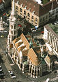
Matthias Church
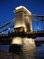
Széchenyi Chain Bridge

Museum of Fine Arts
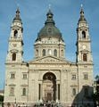
Saint Stephen's Basilica
- 03hősök tere.JPG
Heroes' Square with the Millenary Monument
- 04Pesti vigado.JPG
Vigadó Concert Hall

Vajdahunyad Castle
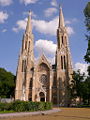
Saint Elisabeth Church
- Fireworks on the Danube.jpg
Fireworks near Széchenyi Chain Bridge
- 001parizsi.JPG
Grey Friars Square
- Budapestoldchurch100.jpg
Inner City Parish Church (Pest, 12th century)
St. Anne Church in Buda


ReferencesISBN links support NWE through referral fees
- Sugar, Peter F., Péter Hanák, and Tibor Frank. 1990. A History of Hungary. Bloomington: Indiana University Press. ISBN 9780253355782
- DK Publishing, Budapest: Eyewitness Travel Guildes. DK Travel, 2007. ISBN 978-0756624354
- Annabel Barber, Visible Cities Budapest: A City Guide. Somerset, Ltd., 2004. ISBN 978-9632129860
- Krisztian Ungvary (Author), John Lukacs (Foreword), The Siege of Budapest: One Hundred Days in World War II. Yale University Press, 2006. ISBN 978-0300119855
- Encyclopaedia Britannica Budapest Retrieved August 9, 2008.
External links
- Budapest portal Retrieved August 11, 2008.
- Budapest Tourist Office Retrieved August 10, 2008.
- Public transport in Budapest Retrieved August 11, 2008.
- MÁV-Start Railway Passenger Transport Co.
- Travel guide to Budapest from Wikitravel
Credits
New World Encyclopedia writers and editors rewrote and completed the Wikipedia article in accordance with New World Encyclopedia standards. This article abides by terms of the Creative Commons CC-by-sa 3.0 License (CC-by-sa), which may be used and disseminated with proper attribution. Credit is due under the terms of this license that can reference both the New World Encyclopedia contributors and the selfless volunteer contributors of the Wikimedia Foundation. To cite this article click here for a list of acceptable citing formats.The history of earlier contributions by wikipedians is accessible to researchers here:
The history of this article since it was imported to New World Encyclopedia:
Note: Some restrictions may apply to use of individual images which are separately licensed.
- ↑ Cite error: Invalid
<ref>tag; no text was provided for refs namedTravel - ↑ Cite error: Invalid
<ref>tag; no text was provided for refs namedEncarta - ↑ Out of Darkness, New Life. The New York Times (2007-12-30). Retrieved 2008-03-12.