Samarra, Iraq
(→Notes) |
Rosie Tanabe (talk | contribs) |
||
| (22 intermediate revisions by 9 users not shown) | |||
| Line 1: | Line 1: | ||
| − | {{ | + | {{Images OK}}{{submitted}}{{approved}}{{Paid}}{{copyedited}} |
{{epname|Samarra, Iraq}} | {{epname|Samarra, Iraq}} | ||
| − | + | [[Image:Golden-Mosque-Samarra.jpg|thumb|350px|Samarra's Golden Mosque before it was bombed]] | |
| − | + | '''Sāmarrā''' ([[Arabic]],'''سامراء''') is a town in [[Iraq]] that in ancient times may have been the world's largest city. With its majestic [[mosques]], [[garden]]s, and ruins of royal [[palace]]s extending 5.6 miles by 21.1 miles along the [[Tigris River]], Samarra is one of four [[Islam]]ic holy cities in Iraq. The home to a population of around 200,000, it stands on the east bank of the Tigris in the [[Salah ad Din Governorate]], 60 miles north of [[Baghdad]]. | |
| − | |||
| − | |||
| − | |||
| − | |||
| − | |||
| − | |||
| − | |||
| − | |||
| − | | | ||
| − | | | ||
| − | | | ||
| − | |||
| − | |||
| − | |||
| − | |||
| − | |||
| − | |||
| − | |||
| − | |||
| − | |||
| − | |||
| − | |||
| − | |||
| − | |||
| − | |||
| − | |||
| − | |||
| − | |||
| − | |||
| − | |||
| − | |||
| − | |||
| − | |||
| − | |||
| − | |||
| − | |||
| − | |||
| − | |||
| − | |||
| − | |||
| − | |||
| − | |||
| − | |||
| − | |||
| − | |||
| − | |||
| − | |||
| − | |||
| − | |||
| − | |||
| − | |||
| − | |||
| − | |||
| − | |||
| − | |||
| − | |||
| − | |||
| − | |||
| − | |||
| − | |||
| − | |||
| − | |||
| − | |||
| − | |||
| − | |||
| − | |||
| − | |||
| − | |||
| − | |||
| − | |||
| − | |||
| − | |||
| − | |||
| − | |||
| − | |||
| − | |||
| − | |||
| − | |||
| − | |||
| − | |||
| − | |||
| − | |||
| − | |||
| − | |||
| − | |||
| − | |||
| − | |||
| − | |||
| − | |||
| − | |||
| − | |||
| − | |||
| − | |||
| − | |||
| − | |||
| − | |||
| − | |||
| − | |||
| − | |||
| − | |||
| − | |||
| − | |||
| − | |||
| − | |||
| − | |||
| − | |||
| − | |||
| − | |||
| − | '''Sāmarrā''' ([[Arabic]],'''سامراء''') is a town in [[Iraq]] | ||
| − | |||
| − | + | From the time it was built by [[Caliph Al-Mu'tasim]] in 836 C.E. to replace Baghdad as the capital of the [[Abbasid Caliphate]], until it was abandoned by [[Caliph Al-Mu'tamid]] in 892 C.E., Samarra was the most important center in the [[Muslim]] world. Its [[Great Mosque of Samarra|Great Mosque]] was the largest Mosque in the world at the time. Despite the short stay of the Abbasid Caliphate in Samarra, the city's artistic, literary, and scientific splendors have remained an important part of Arab and Islamic history. | |
| − | In 2007, [[UNESCO]] named Samarra one of its [[World Heritage Sites]].<ref>http://news.bbc.co.uk/2/hi/asia-pacific/6248244.stm</ref> | + | Medieval Islamic writers believed that the city's name was derived from the [[Arabic]] phrase, “Sarre men ra’a”—سر من رأى—which translates to “A joy for all who see.” It was changed later by Armenian soldiers to "Samarra"—ساء من رأى—which means "A sadness for all who see." |
| + | |||
| + | Today, Samarra is a [[trade]] center of its region, and has some [[industry]] and small [[craft]]s production, as well as local administration. On February 22, 2006, a powerful explosion shattered the dome of Samarra's Al-Askari [[Golden Mosque]], one of Iraq's most revered [[Shiite]] [[shrine]]s, setting off a day of sectarian fury in cities and towns across Iraq. | ||
| + | {{toc}} | ||
| + | In 2007, [[UNESCO]] named Samarra one of its [[World Heritage Sites]].<ref>BBC News, [http://news.bbc.co.uk/2/hi/asia-pacific/6248244.stm Unesco names World Heritage sites.] Retrieved September 2, 2007.</ref> | ||
==Ancient Samarra== | ==Ancient Samarra== | ||
| − | + | [[Image:Irak umkreis bagdad.png|thumb|350px|Map shows the location of Samarra northwest of Baghdad on the banks of the Tigris River.]] | |
| − | + | Samarra was heavily occupied in ancient times during the [[Chalcolithic]] Samarran Culture (c. 5500–4800 B.C.E.) identified at the site of [[Tell Sawwan]], where evidence of irrigation and [[flax]] production establishes the presence of a prosperous settled culture with a highly organized social structure. The culture is primarily known by its finely made [[pottery]] decorated against dark-fired backgrounds with stylized figures of animals, birds, and geometric designs. This widely exported type of pottery was one of the first widespread, relatively uniform pottery styles in the [[Ancient Near East]]. The Samarran Culture was the precursor to the [[Mesopotamia]]n culture of the [[Ubaid period]]. | |
| − | + | The city of [[Sur-marrati]]—re-founded by the Assyrian King [[Sennacherib]] in 690 B.C.E. according to a [[stele]] currently in the [[Walters Art Gallery]], [[Baltimore]]—is identified with a fortified [[Assyria]]n site at al-Huwaysh, on the Tigris opposite modern Samarra. | |
| − | The possibility of a larger population | + | The possibility of a larger population came with the opening of the Qatul al-Kisrawi, the northern extension of the [[Nahrawan]] canal that drew water from the [[Tigris]] in the region of Samarra. This work was attributed by [[Yaqut]] to the [[Sassanid Empire|Sassanid]] king [[Khosrau I of Persia|Khosrau I Anushirvan]] (531–578 C.E.). To celebrate the completion of this project, a commemorative tower (modern Burj al-Qa'im) was built at the southern inlet south of Samarra, and a palace with a "paradise," or walled hunting park, was constructed at the northern inlet (modern [[Nahr al-Rasasi]]) near to [[al-Daur]]. A supplementary canal, the Qatul Abi al-Jund, was created by the [[Abbasid Caliphate|Abbasid Caliph]] [[Harun al-Rashid]] and a planned city was laid out in the form of a regular octagon, but he abandoned it unfinished in 796 C.E. |
==Abbasid capital== | ==Abbasid capital== | ||
| − | |||
| − | + | The latter sponsored the construction of the [[Great Mosque of Samarra]] with its spiral [[minaret]] or malwiyah, built in 847 C.E. He also laid out parks and a palace for his son [[Al-Mu'tazz]]. Under the rule of [[Al-Mu'tadid]], the Abbassid capital was shifted back to Baghdad and Samarra entered a prolonged decline, which accelerated after the [[thirteenth century]] when the course of the Tigris shifted. | |
| − | The | + | The Great Mosque of Samarra was at one time the largest mosque in the world. Its minaret, the Malwiya Tower, is a vast spiraling cone 52 meters high and 33 meters wide with a spiral ramp. The mosque had 17 aisles and its walls were paneled with mosaics of dark blue glass. On April 1, 2005, the top of the minaret was damaged by a bomb. Insurgents reportedly attacked the tower because U.S. troops had been using it as a sniper position. |
| − | == | + | ==Al-Askari Mosque== |
| − | [[Image: | + | [[Image:Al-Askari Mosque 2006.jpg|thumb|left|250px|The Al-Askari (Golden) Mosque after being bombed in 2006]] |
| − | The city is also home to the [[Al-Askari Mosque]] | + | The city is also home to the [[Al-Askari Mosque]]—also called the Golden Mosque—containing the mausoleums of the [[Ali al-Hadi]] and [[Hasan al-Askari]], the tenth and eleventh [[Shi'a Imams]], respectively. It also contains the sacred shrine of [[Muhammad al-Mahdi]], known as the twelfth, or "Hidden Imam," destined to return to as the [[Mahdi]] in the [[Shi'a]] tradition. This has made it a central pilgrimage center for Shi'a Muslims of the "Twelver," sect, estimated to comprise 80 percent of Shi'as. |
| − | + | In addition, [[Hakimah Khatun]] and [[Narjis Khatun]], female relatives of the prophet [[Mohammad]], held in high esteem by Shi'a and Sunni Muslims alike, are buried there, making this mosque one of the most significant sites of worship for Shi'a and a venerated location for Sunni Muslims. Samarra's native population is believed to be largely descended from a lineage related to these saints, although most of these citizens of Samarra are Sunnis who do not share the same religious tradition of the Shi'a. | |
==Modern era== | ==Modern era== | ||
| − | + | [[Image:Children in Samarra.jpg|thumb|left|300px|Children in a Samarra neighborhood]] | |
| + | During the twentieth century, Samarra gained new importance when a permanent body of water ([[Lake Tharthar]]) was created near the town by damming the river in order to end the frequent flooding of Baghdad downstream. Many local people were displaced by the dam, resulting in a big increase in Samarra's population. | ||
| + | |||
| + | Samarra is currently a key city in [[Salah ad Din Governorate|Salahuddin province]], a major part of the so-called [[Sunni Triangle]] where insurgents have been active since shortly after the 2003 invasion by the United States. Though Samarra is famous as a site of Shi'a holy sites, including the tombs of several [[Shi'a Imam]]s, the town is dominated by Sunnis. This has caused tensions, particularly since the [[2003 invasion of Iraq]]. | ||
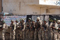
| − | + | [[Image:Golden Mosque storming.jpg|thumb|250px|Iraqi National Guard soldiers prepare to enter the Al Askari Mosque on Oct. 1, 2004 after it had been seized by insurgents.]] | |
| − | + | When [[Saddam Husein]] was in power, he forbade pilgrimages to Shi'a holy sites, fearing that large gatherings would quickly turn into political uprisings. Such religious activities resumed only after his downfall in 2003, in an attempt to establish the principle of [[religious freedom]] for all Iraqis. | |
| + | On February 22, 2006, the golden dome of the [[Al Askari Mosque]] was [[al-Askari Mosque bombing (2006)|destroyed by bombs]], setting off a period of rioting and reprisal attacks across the country which claimed hundreds of lives. No organizations have claimed responsibility, however it is believed that the Sunni [[Islamist]] [[Mujahideen Shura Council]], or groups sympathetic to its cause, were behind the attack. Some in the Islamic world, however, are convinced that the American government was behind it. | ||
| + | On June 13, 2007, suspected [[al-Qaeda]] insurgents [[al-Askari Mosque bombing (2007)|attacked the mosque]] again and destroyed the two [[Minaret|minarets]] that flanked the dome's ruins. The mosque compound and minarets had been closed since the 2006 bombing. | ||
| − | ==Notes== | + | ==Notes== |
| − | + | <references/> | |
==References== | ==References== | ||
| − | *O'Hara, John. ''Appointment in Samarra'', | + | * O'Hara, John. ''Appointment in Samarra''. Vintage, 2003. ISBN 978-0375719202 |
| − | *Parker, Philip M. ''The 2006 Economic and Product Market Databook for Samarra, Iraq'' | + | * Parker, Philip M. ''The 2006 Economic and Product Market Databook for Samarra, Iraq''. ICON Group International, 2006. ISBN 978-0497814120 |
| − | *Robinson, Chase F. ''A Medieval Islamic City Reconsidered: An Interdisciplinary Approach to Samarra'' | + | * Robinson, Chase F. ''A Medieval Islamic City Reconsidered: An Interdisciplinary Approach to Samarra''. Oxford University Press, 2002. ISBN 978-0197280249 |
==External links== | ==External links== | ||
| − | + | All links retrieved December 22, 2022. | |
| − | *http://i-cias.com/e.o/samarra.htm | + | * [http://i-cias.com/e.o/samarra.htm LookLex Encyclopedia: Samarra]. ''i-cias.com''. |
| − | *[http://www.indybay.org/newsitems/2006/02/28/43052.php Destruction of Askari Mosque] | + | * [http://www.indybay.org/newsitems/2006/02/28/43052.php Destruction of Askari Mosque]. ''www.indybay.org''. |
| − | + | ||
{{Credit|146196633}} | {{Credit|146196633}} | ||
| + | |||
| + | [[Category:Geography]] | ||
Latest revision as of 02:08, 23 December 2022
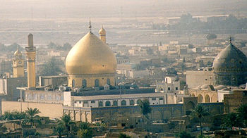
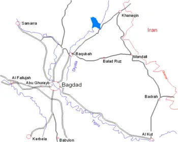
Sāmarrā (Arabic,سامراء) is a town in Iraq that in ancient times may have been the world's largest city. With its majestic mosques, gardens, and ruins of royal palaces extending 5.6 miles by 21.1 miles along the Tigris River, Samarra is one of four Islamic holy cities in Iraq. The home to a population of around 200,000, it stands on the east bank of the Tigris in the Salah ad Din Governorate, 60 miles north of Baghdad.
From the time it was built by Caliph Al-Mu'tasim in 836 C.E. to replace Baghdad as the capital of the Abbasid Caliphate, until it was abandoned by Caliph Al-Mu'tamid in 892 C.E., Samarra was the most important center in the Muslim world. Its Great Mosque was the largest Mosque in the world at the time. Despite the short stay of the Abbasid Caliphate in Samarra, the city's artistic, literary, and scientific splendors have remained an important part of Arab and Islamic history.
Medieval Islamic writers believed that the city's name was derived from the Arabic phrase, “Sarre men ra’a”—سر من رأى—which translates to “A joy for all who see.” It was changed later by Armenian soldiers to "Samarra"—ساء من رأى—which means "A sadness for all who see."
Today, Samarra is a trade center of its region, and has some industry and small crafts production, as well as local administration. On February 22, 2006, a powerful explosion shattered the dome of Samarra's Al-Askari Golden Mosque, one of Iraq's most revered Shiite shrines, setting off a day of sectarian fury in cities and towns across Iraq.
In 2007, UNESCO named Samarra one of its World Heritage Sites.[1]
Ancient Samarra
Samarra was heavily occupied in ancient times during the Chalcolithic Samarran Culture (c. 5500–4800 B.C.E.) identified at the site of Tell Sawwan, where evidence of irrigation and flax production establishes the presence of a prosperous settled culture with a highly organized social structure. The culture is primarily known by its finely made pottery decorated against dark-fired backgrounds with stylized figures of animals, birds, and geometric designs. This widely exported type of pottery was one of the first widespread, relatively uniform pottery styles in the Ancient Near East. The Samarran Culture was the precursor to the Mesopotamian culture of the Ubaid period.
The city of Sur-marrati—re-founded by the Assyrian King Sennacherib in 690 B.C.E. according to a stele currently in the Walters Art Gallery, Baltimore—is identified with a fortified Assyrian site at al-Huwaysh, on the Tigris opposite modern Samarra.
The possibility of a larger population came with the opening of the Qatul al-Kisrawi, the northern extension of the Nahrawan canal that drew water from the Tigris in the region of Samarra. This work was attributed by Yaqut to the Sassanid king Khosrau I Anushirvan (531–578 C.E.). To celebrate the completion of this project, a commemorative tower (modern Burj al-Qa'im) was built at the southern inlet south of Samarra, and a palace with a "paradise," or walled hunting park, was constructed at the northern inlet (modern Nahr al-Rasasi) near to al-Daur. A supplementary canal, the Qatul Abi al-Jund, was created by the Abbasid Caliph Harun al-Rashid and a planned city was laid out in the form of a regular octagon, but he abandoned it unfinished in 796 C.E.
Abbasid capital
The latter sponsored the construction of the Great Mosque of Samarra with its spiral minaret or malwiyah, built in 847 C.E. He also laid out parks and a palace for his son Al-Mu'tazz. Under the rule of Al-Mu'tadid, the Abbassid capital was shifted back to Baghdad and Samarra entered a prolonged decline, which accelerated after the thirteenth century when the course of the Tigris shifted.
The Great Mosque of Samarra was at one time the largest mosque in the world. Its minaret, the Malwiya Tower, is a vast spiraling cone 52 meters high and 33 meters wide with a spiral ramp. The mosque had 17 aisles and its walls were paneled with mosaics of dark blue glass. On April 1, 2005, the top of the minaret was damaged by a bomb. Insurgents reportedly attacked the tower because U.S. troops had been using it as a sniper position.
Al-Askari Mosque
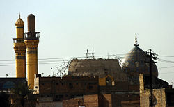
The city is also home to the Al-Askari Mosque—also called the Golden Mosque—containing the mausoleums of the Ali al-Hadi and Hasan al-Askari, the tenth and eleventh Shi'a Imams, respectively. It also contains the sacred shrine of Muhammad al-Mahdi, known as the twelfth, or "Hidden Imam," destined to return to as the Mahdi in the Shi'a tradition. This has made it a central pilgrimage center for Shi'a Muslims of the "Twelver," sect, estimated to comprise 80 percent of Shi'as.
In addition, Hakimah Khatun and Narjis Khatun, female relatives of the prophet Mohammad, held in high esteem by Shi'a and Sunni Muslims alike, are buried there, making this mosque one of the most significant sites of worship for Shi'a and a venerated location for Sunni Muslims. Samarra's native population is believed to be largely descended from a lineage related to these saints, although most of these citizens of Samarra are Sunnis who do not share the same religious tradition of the Shi'a.
Modern era
During the twentieth century, Samarra gained new importance when a permanent body of water (Lake Tharthar) was created near the town by damming the river in order to end the frequent flooding of Baghdad downstream. Many local people were displaced by the dam, resulting in a big increase in Samarra's population.
Samarra is currently a key city in Salahuddin province, a major part of the so-called Sunni Triangle where insurgents have been active since shortly after the 2003 invasion by the United States. Though Samarra is famous as a site of Shi'a holy sites, including the tombs of several Shi'a Imams, the town is dominated by Sunnis. This has caused tensions, particularly since the 2003 invasion of Iraq.
When Saddam Husein was in power, he forbade pilgrimages to Shi'a holy sites, fearing that large gatherings would quickly turn into political uprisings. Such religious activities resumed only after his downfall in 2003, in an attempt to establish the principle of religious freedom for all Iraqis.
On February 22, 2006, the golden dome of the Al Askari Mosque was destroyed by bombs, setting off a period of rioting and reprisal attacks across the country which claimed hundreds of lives. No organizations have claimed responsibility, however it is believed that the Sunni Islamist Mujahideen Shura Council, or groups sympathetic to its cause, were behind the attack. Some in the Islamic world, however, are convinced that the American government was behind it.
On June 13, 2007, suspected al-Qaeda insurgents attacked the mosque again and destroyed the two minarets that flanked the dome's ruins. The mosque compound and minarets had been closed since the 2006 bombing.
Notes
- ↑ BBC News, Unesco names World Heritage sites. Retrieved September 2, 2007.
ReferencesISBN links support NWE through referral fees
- O'Hara, John. Appointment in Samarra. Vintage, 2003. ISBN 978-0375719202
- Parker, Philip M. The 2006 Economic and Product Market Databook for Samarra, Iraq. ICON Group International, 2006. ISBN 978-0497814120
- Robinson, Chase F. A Medieval Islamic City Reconsidered: An Interdisciplinary Approach to Samarra. Oxford University Press, 2002. ISBN 978-0197280249
External links
All links retrieved December 22, 2022.
- LookLex Encyclopedia: Samarra. i-cias.com.
- Destruction of Askari Mosque. www.indybay.org.
Credits
New World Encyclopedia writers and editors rewrote and completed the Wikipedia article in accordance with New World Encyclopedia standards. This article abides by terms of the Creative Commons CC-by-sa 3.0 License (CC-by-sa), which may be used and disseminated with proper attribution. Credit is due under the terms of this license that can reference both the New World Encyclopedia contributors and the selfless volunteer contributors of the Wikimedia Foundation. To cite this article click here for a list of acceptable citing formats.The history of earlier contributions by wikipedians is accessible to researchers here:
The history of this article since it was imported to New World Encyclopedia:
Note: Some restrictions may apply to use of individual images which are separately licensed.
