Réunion
| Région Réunion | ||
|---|---|---|
|
Logo of Reunion | |
| (Region flag) | (Region logo) | |
| Location | ||
| ||
| Administration | ||
| Capital | Saint-Denis | |
| Regional President | Paul Vergès (PCR) (since 1998) | |
| Departments | Réunion | |
| Arrondissements | 4 | |
| Cantons | 49 | |
| Communes | 24 | |
| Statistics | ||
| Land area1 | 2,512 km² | |
| Population | (Ranked 21st) | |
| - January 1, 2006 est. | 784,000 | |
| - March 8, 1999 census | 706,300 | |
| - Density (2006) | 312/km² | |
| 1 French Land Register data, which exclude lakes, ponds, and glaciers larger than 1 km² (0.386 sq. mi. or 247 acres) as well as the estuaries of rivers | ||
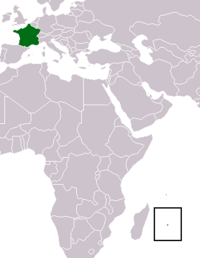
Réunion is an island, located in the Indian Ocean east of Madagascar, about 130 miles (200 km) southwest of Mauritius, the nearest island. Administratively, Réunion is one of the overseas départements of France. Like the others, Réunion is also one of the twenty-six regions of France (being an overseas region) and an integral part of the Republic with the same status as those situated on the European mainland. As an outer region of the European Union, the currency used is the euro.
Geography
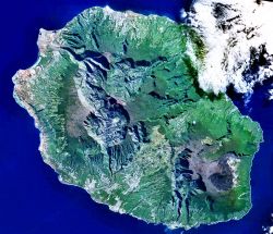
The island is 39 miles (63 km) long; 28 miles (45 km) wide; and covers 970 square miles (2512 sq km). It is similar to the island Hawaii insofar as both are located above hotspots in Earth's crust.
The Piton de la Fournaise, a shield volcano on the eastern end of Réunion Island, rises more than 8,565 feet (2611 m) above sea level and is sometimes called a sister to Hawaiian volcanoes because of the similarity of climate and volcanic nature. It has erupted more than 100 times since 1640 and is under constant monitoring. It most recently erupted on April 4, 2007. The lava flow from this eruption was estimated at 3 million m3 (about 4 million cubic yards) per day. The Piton de la Fournaise is created by a hotspot volcano, which also created the Piton des Neiges and the islands of Mauritius and Rodrigues.
The Piton des Neiges volcano, the highest point on the island at 10,069 feet (3070 m) above sea level, is northwest of the Piton de la Fournaise. Collapsed calderas and canyons are southwest of the mountain. Like Mauna Kea on the big island of Hawaii, Piton des Neiges is extinct. Despite its name, snow (French: neige) practically never falls on the summit.
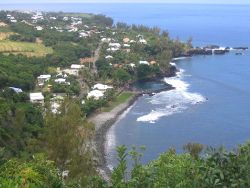
The slopes of both volcanoes are heavily forested. Cultivated land and cities like the capital city of Saint-Denis are concentrated on the surrounding coastal lowlands.
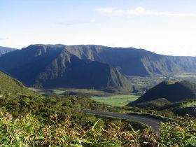
Réunion also has three calderas: the Cirque de Salazie, the Cirque de Cilaos, and the Cirque de Mafate. The latter is accessible only by foot or helicopter.
Between March 15 and 16, 1952, Cilaos at the center of Réunion received 73.6 inches (1,869.9 mm) of rainfall. This is the greatest 24-hour precipitation total ever recorded on Earth. The island also holds the record for most rainfall in 72 hours, 154.7 inches (3,929 mm) at Commerson's Crater in March 2007.
History
Arab sailors formerly called the island Adna Al Maghribain (“Western Island”). The Portuguese were the first Europeans to visit, finding it uninhabited in 1513 and naming it Santa Apollonia, after Saint Apollonia.
The island was occupied by France and administered from Port Louis, Mauritius. Although the French flag was hoisted in 1638, Santa Apollonia was officially claimed by Jacques Pronis of France in 1642, when he deported a dozen French mutineers to the island from Madagascar. The convicts were returned to France several years later, and in 1649, the island was named Île Bourbon after the royal house.
“Réunion” was the name given to the island in 1793 with the fall of the House of Bourbon in France; the name commemorates the union of revolutionaries from Marseille with the National Guard in Paris, which took place on August 10, 1792. In 1801, the island was renamed "Île Bonaparte," after Napoleon Bonaparte. The island was taken by the British navy in 1810, which used the old name of “Bourbon.” When it was restored to France by the Congress of Vienna in 1815, the island retained the name of "Bourbon" until 1848, when the fall of the restored Bourbons during the revolutions during that year meant that the island became “Réunion” once again.
From the seventeenth to the nineteenth centuries, French immigration supplemented by influxes of Africans, Chinese, Malays, and Indians gave the island its ethnic mix. The opening of the Suez Canal in 1869 cost the island its importance as a stopover on the East Indies trade route.
Réunion became an overseas department of France on March 19, 1946.
In 2005 and 2006 Réunion was hit by a crippling epidemic of chikungunya, a disease spread by mosquitoes. About 255,000 people on Réunion reportedly contracted the disease, which also spread to Madagascar and to mainland France through airline travel. The disease led to more than 200 deaths on Réunion. There is no known cure.
Politics
Réunion sends five deputies to the French National Assembly and three senators to the French Senate.
Administrative divisions
Administratively, Réunion is divided into 4 arrondissements, 24 communes, and 47 cantons. It is a French overseas département as well as a French region. The low number of communes, compared to French metropolitan departments of similar size and population, is unique; most Réunionnaises communes encompass several localities, sometimes separated by significant distances.
Réunion is part of the Indian Ocean Commission.
Major communities
- Le Port
- Le Tampon
- Saint-André
- Saint-Denis
- Saint-Louis
- Saint-Paul
- Saint-Pierre
Economy
Sugar is the chief agricultural product and export. Tourism is also an important source of income. As of 2005, the people earned a per capita annual GDP of some $6,200. While this is exceptionally high compared with its neighbors in Madagascar and the African continent, it is only 20 percent of the $29,600 per capita GDP of France as a whole. The island is highly dependent on aid from continental France.
Demographics
Réunion contains most of the same ethnic populations as Mauritius: Indian (including Tamil), Vietnamese, African, Malagasy, Chinese and ethnic French - but in different proportions. Creoles, of mixed origins, make up the majority of the population. Whites make up approximately one-quarter of the population, Indians make up 21 percent and people of Chinese or Vietnamese ancestry most of the remainder.
While Gujarati and Tamil people make up the majority of the Indo-Réunionnaise people, people of Hindi, Urdu, Bhojpuri and other origins form the remainder of the population
Reunion is very similar in culture, ethnic makeup, language, and traditions to Mauritius and the Seychelles.
Historical population
| 1671 estimate |
1696 estimate |
1704 estimate |
1713 estimate |
1717 estimate |
1724 estimate |
1764 estimate |
1777 estimate |
1789 estimate |
|---|---|---|---|---|---|---|---|---|
| 90 | 269 | 734 | 1,171 | 2,000 | 12,550 | 25,000 | 35,100 | 61,300 |
| 1826 estimate |
1830 estimate |
1848 estimate |
1849 estimate |
1860 estimate |
1870 estimate |
1887 census |
1897 census |
1926 census |
| 87,100 | 101,300 | 110,300 | 120,900 | 200,000 | 212,000 | 163,881 | 173,192 | 182,637 |
| 1946 census |
1954 census |
1961 census |
1967 census |
1974 census |
1982 census |
1990 census |
1999 census |
2006 estimate |
| 241,708 | 274,370 | 349,282 | 416,525 | 476,675 | 515,814 | 597,823 | 706,300 | 784,000 |
| Official figures from past censuses and INSEE estimates. | ||||||||
Religion
The predominant religion is Roman Catholicism (86 percent of the population in 1995), with Hinduism, Islam, and Buddhism also represented.
Culture
Réunionese culture is a blend (métissage) of European, African, Tamil, Indian, Chinese and insular traditions.
The most widely spoken language, Réunion Creole, derives from French, with many idiosyncrasies. Réunion Creole is now taught in some schools. However, an official orthography has yet to be agreed upon.
Local food and music blend influences from Africa, India, China and Europe.
Wildlife
External links
Government
Overviews
Tourism
- Walks Online - Portal About the Reunion Island (Czech-French-English)
- Official Tourism web site
- Portal about the reunion island (french - english)
- Images of Reunion
- WillGoTo - Réunion Travel Guide and Directory
- Comprehensive online guide to Reunion Island
- Lonely Planet - World Guide: Reunion
- Pearl Island probably the only English website from the island about the island
- Photogallery: waterfalls, rain forest, pedestrian excursion, volcano "La Fournaise," coast, river, beaches...
Fauna and flora
- Scientific research application on the nature reserve of Mare-Longue (THERESIEN project)
- Flora - Botanic garden - Rain forest (Photogallery)
Other
- Weather forecast
- Daniel Lacouture's site
- Map of Reunion island
- Tamil Accommodation in Reunion
- Aerial photo of the Gorges of the Bras de Caverne
- Weather on Reunion island
- Google Maps Imagery of Reunion
- Foreign perspective on Réunion from a British resident
Credits
New World Encyclopedia writers and editors rewrote and completed the Wikipedia article in accordance with New World Encyclopedia standards. This article abides by terms of the Creative Commons CC-by-sa 3.0 License (CC-by-sa), which may be used and disseminated with proper attribution. Credit is due under the terms of this license that can reference both the New World Encyclopedia contributors and the selfless volunteer contributors of the Wikimedia Foundation. To cite this article click here for a list of acceptable citing formats.The history of earlier contributions by wikipedians is accessible to researchers here:
The history of this article since it was imported to New World Encyclopedia:
Note: Some restrictions may apply to use of individual images which are separately licensed.
