Nilgiris district

The Nilgiris District is in the Indian state of Tamil Nadu. Nilgiri (Tamil : நீலகிரி or Blue Mountains when translated into English) is also the name given to a range of mountains spread across the states of Tamilnadu as well as Karnataka and Kerala. The Nilgiri Hills comprise part of a larger mountain chain known as the Western Ghats. The mountain Doddabetta has the highest elevation, standing at a height of 2,637 meters. The district resides mainly contained within that mountain range.
History

Human history in the Nilgiri hills dates back many centuries. The reason they have been called the Blue Mountains remains unclear. Several sources cite the smoky-like haze that envelopes the area, while other sources cite the kurunji flower, which blooms every twelve years giving the slopes a bluish tinge.
Originally tribal land, the Todas occupied the the Ooty area and the Kotas the Kotagiri area. The Badagas appeared much later, migrating from the Mysore Plateau, in 1550 C.E.. The Ramayana of Valmiki (estimated by Western scholars to have been recorded in the second century B.C.E.) mentions the Nilgiri hills. Europeans first set foot the jungles in 1602 when a Portuguese priest, Ferreiri, successfully explored the hills. He discovered the Toda people. Ferreiri remained the only European to explore this area for more than two hundred years.
Around 1810, the the British East India Company unsuccessfully attempted to survey the Nilgiris Hills jungles. Englishman Francis Buchanan led the failed surveying expedition. Next John Sullivan, the Collector of Coimbatore just south of the Nilgiris, sent two surveyors, Keys and Macmohan, to make a comprehensive study of the hills. They went as far as the lower level of Ooty but failed to explore the entire valley. Keys' and Macmohan's (their first names had not been recored) mission held significance as they had been the first Englishmen to set foot in the Nilgiri hills, leading to the opening of the area to British colonialism.
Although Keys and Macmohan made the first extensive trip in the region, the credit for the thorough exploration of the region has been attributed to J.C. Whish and N.W. Kindersley. They worked for the Madras Civil Service, making a journey in 1819 into the Nilgiris Hills. They reported to their superiors that they had discovered "the existence of a tableland possessing a European climate." [1]
John Sullivan, the Collector of Coimbatore, who went up the same year and built a home, had been the first European resident of the hills. He reported to the Madras Government the suitability of the climate; Europeans soon thereafter settled in the valley for year round and for summer stays. The valley became a summer resort with the British government using the hills for a summer capital. By the end of the nineteenth century, the Nilgiri hills became easily accessible with the building of roads and the construction of a railroad.
Geography and climate

The district has an area of 2,452.50 sq.km.[2] The district is basically a hilly region, situated at an elevation of 900 to 2,636 meters above MSL. Almost the entire district lies in the Western ghats. Its latitudinal and longitudinal dimensions being 130 KM (Latitude : 10 - 38 WP 11-49N) by 185 KM (Longitude : 76.0 E to 77.15 E). The Nilgiris is bounded on North by Karnataka state on the East by Coimbatore district, Erode district, South by Coimbatore district and Kerala State and as the West by Kerala state. In Nilgiris district the topography is rolling and steep. About 60% of the cultivable land falls under the slopes ranging from 16 to 35%
The altitude of the Nilgiris results in a much cooler and wetter climate than the surrounding plains, so the area is popular as a retreat from the summer heat. During summer the temperature remains to the maximum of 21°C to 25°C and reaches a minimum of 10°C to 12°C. During winter the temperature reaches a maximum of 16°C to 21°C and a minimum of 2°C.[2] The rolling hills of the Downs look very similar to the Downs in Southern England, and were used for similar activities such as hunting.

The district usually receives rain both during South West Monsoon and North East Monsoon. The entire Gudalur and Pandalaur, Kundah Taluks and portion of Udhagamandalam Taluk receive rain by the South West Monsoon and some portion of Udhagamandalam Taluk and the entire Coonoor and Kotagiri Taluks are benefited by the rains of North East Monsoon. There are 16 rainfall registering stations in the district The average annual rainfall of the district is 1,920.80 mm.[2]
The principal town of the area is Ootacamund, or Udhagamandalam, which is the district capital. The town also has several buildings which look very "British," particularly the Churches. There is even a road junction known as Charing Cross. The other main towns in the Nilgiris are Coonoor, Kotagiri, Gudalur and Aruvankadu. The famous tourist spot in Coonoor are Lambsrock and Sims park. In Sims park, a "Fruit Show" is conducted during summer. All the varieties of fruit are displayed during that time. This park is situated on the way of Kotagiri.
District Administration
The Nilgiris District comprises six taluks viz., Udhagamandalam, Kundah, Coonoor, Kotagiri, Gudalur and Pandalur. These taluks are divided in to four Panchayat Unions viz., Udhagamandalam, Coonoor, Kotagiri and Gudalur besides two Municipalities, Wellington Contonment and Aruvankadu Township. The District consists of 56 Revenue Villages and 15 Revenue Firkas. There are two Revenue Divisional in this district viz., Coonoor and Gudalur. There are 35 Village Panchayat and 13 Town Panchayat in this district.[2]
Demographics

It had a population of 7,62,141 as of 2001 and is 59.65% urbanised.[3] The district has a literacy of 81.44%, one of the highest in the state.
There are several tribes living in the Nilgiris, whose origins are uncertain. The best known of these are the Toda people, whose culture is based upon cattle, and whose red, black and white embroidered shawls, and silver jewelry is much sought after. The district is also home to the Paniya tribes and the Badaga people.
Tamil is the principal language spoken in the Nilgiris. Many people speak and understand English. Malayalam, Kannada & Hindi are also used to an extent. The Nilgiris is also home to the Toda language, spoken by the Toda people. The Badaga people, who number around 250,000, speak the Badaga language. The language of Paniya is spoken in the western parts of the district where the Paniya tribes live. As per the 2001 Census, Hindus formed the majority of the population (78.60%), followed by Christians (11.45%), Muslims (9.55%) and others (0.4%).[4]
The table listed below gives the basic census data for the district based on the census of 2001.[2]
| Total Population | Male Population | Female Population | Sex ratio | |
|---|---|---|---|---|
| Rural | 307,532 | 151,874 | 155,658 | 1,025 |
| Urban | 454,609 | 226,477 | 228,132 | 1,007 |
| Total | 762,141 | 378,351 | 383,790 | 1,014 |
Basic infrastructure
Transport

The Nagapattinam - Gudalur National Highway Passes through this district. The Nilgiri Ghat Roads link the district with the nearest cities in Tamilnadu, Kerala and Karnataka. All the taluks are connected with Major District Roads. The village roads are maintained by Panchayat Union.The Nilgiri Mountain Railway from Mettupalayam to Udhagamandalam via Coonoor, is a great tourist attraction. It was used in the film A Passage to India as the railway to the caves. It is a rack railway as far as Coonoor. The Nilgiri Mountain Railway, is now a UNESCO World Heritage Site.[5] This services many of the populated areas of the district including Coonoor, Wellington, Aruvankadu, Ketti, Lovedale and Ooty. There is no sea port or Airport in the district. The nearest international airport to the Nilgiris is at Coimbatore.
Electricity
There are 8 Hydel Power Houses in this district.[2]
1. Pykara Power House 2. Pykara Micro Power House 3. Moyar Power House 4. Kundah Power House - I 5. Kundah Power House -II 6. Kundah Power House - III 7. Kundah Power House - IV 8. Kundah Power House - V
Health infrastructure
There are one District Head Quarters Government Hospital, 5 Taluk Hospitals, 28 Primary Health Centres, 194 Health Sub-Centres and 5 Plague circles in the district.[2]
Agriculture

The Nilgiris District is basically a Horticulture District[2] and the entire economy of the district depends upon the success and failure of Horticulture Crops like Potato, Cabbage, Carrot, Tea, Coffee, Spices and Fruits. The main cultivation is plantation Crops, viz., Tea and Coffee. Tea is grown at elevations of 1,000 to above 2,500 metres. The area also produces Eucalyptus oil and temperate zone vegetables. Potato and other vegetables are raised in Udhagai and Coonoor Taluks. Paddy and Ginger are grown in Gudalur and Pandalur Taluks. Paddy is also grown in Thengumarahada area in Kotagiri Taluk. Besides these crops, Ragi, Samai, Wheat, Vegetables etc., are also grown in small extent throughout the district. There are no irrigation schemes in this district. The crops are mainly rain fed. Check Dams have been constructed wherever it is possible to exploit natural springs.
Ecoregions


Two ecoregions cover portions of the Nilgiris. The South Western Ghats moist deciduous forests lie between 250 and 1000 meters elevation. These forests extend south along the Western Ghats range to the southern tip of India. These forests are dominated by a diverse assemblage of trees, many of whom are deciduous during the winter and spring dry season. These forests are home to the largest herd of Asian Elephants in India, who range from the Nilgiris across to the Eastern Ghats. The Nilgiris and the South Western Ghats is also one of the most important tiger habitats left in India.
The South Western Ghats montane rain forests ecoregion covers the portion of the range above 1000 meters elevation. These evergreen rain forests are among the most diverse on the planet. Above 1500 meters elevation, the evergreen forests begin to give way to stunted forests, called sholas, which are interspersed with open grassland. These grasslands are the home to the endangered Nilgiri Tahr, which resembles a stocky goat with curved horns. The Nilgiri Tahrs are found only in the montane grasslands of the South Western Ghats, and number only about 2000 individuals.

Three national parks protect portions of the Nilgiris. Mudumalai National Park lies in the northern part of the range where Kerala, Karnataka, and Tamil Nadu meet, and covers an area of 321 km². Mukurthi National Park lies in the southwest of the range, in Kerala, and covers an area of 78.5 km², which includes intact shola-grassland mosaic, habitat for the Nilgiri tahr. Silent Valley National Park is just to the south and contiguous with these two parks, and covers an area of 89.52 km². Outside of these parks much of the native forest has been cleared for grazing cattle, or for plantations of tea, Eucalyptus, ganga and Acacia. The entire range, together with portions of the Western Ghats to the northwest and southwest, was included in the Nilgiri Biosphere Reserve in 1986, India's first biosphere reserve.
The region has given its name to a number of bird species, including the Nilgiri Pipit, Nilgiri Woodpigeon and Nilgiri Blackbird.There is a village KUKKAL where agricultral products are available in huge amount.
Gallery
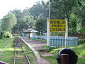
Lovedale railway station

Udhagamandalam railway station
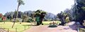
Botanical Gardens at Udhagamandalam
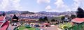
A panaromic view of Udhagamandalam


See also
- Badaga Hattis
Notes
- ↑ Madras (India : State). 1885. Manual of the administration of the Madras Presidency: in illustration of the records of government & the yearly administration reports (Madras: Printed by E. Keys at the Government Press), p. 108.
- ↑ 2.0 2.1 2.2 2.3 2.4 2.5 2.6 2.7 Welcome to Nilgiris. Retrieved September 3, 2008.
- ↑ Tamil Nadu Census 2001. Retrieved September 3, 2008.
- ↑ Religion Census. Retrieved September 3, 2008.
- ↑ Official UNESCO list of World Heritage Sites - Mountain Railways of India. Retrieved September 3, 2008.
ReferencesISBN links support NWE through referral fees
- Madras (India : State). 1885. Manual of the administration of the Madras Presidency: in illustration of the records of government & the yearly administration reports. Madras: Printed by E. Keys at the Government Press. OCLC 221456000.
External links
- Nilgiris.Mobi @ Mobile (A Mobile Site). Retrieved September 3, 2008.
- Your guide to the Nilgiris. Retrieved September 3, 2008.
- The Nilgiris District. Retrieved September 3, 2008.
- Photos from Nilgiri District. Retrieved September 3, 2008.
- Travel Information. Retrieved September 3, 2008.
| |||||||||||||||||


| |||||||||||
Credits
New World Encyclopedia writers and editors rewrote and completed the Wikipedia article in accordance with New World Encyclopedia standards. This article abides by terms of the Creative Commons CC-by-sa 3.0 License (CC-by-sa), which may be used and disseminated with proper attribution. Credit is due under the terms of this license that can reference both the New World Encyclopedia contributors and the selfless volunteer contributors of the Wikimedia Foundation. To cite this article click here for a list of acceptable citing formats.The history of earlier contributions by wikipedians is accessible to researchers here:
The history of this article since it was imported to New World Encyclopedia:
Note: Some restrictions may apply to use of individual images which are separately licensed.