Difference between revisions of "Mount Abu" - New World Encyclopedia
Nim Ruparel (talk | contribs) |
({{Contracted}}) |
||
| Line 1: | Line 1: | ||
| − | {{ready}} | + | {{ready}}{{Contracted}} |
{{Infobox Indian Jurisdiction | | {{Infobox Indian Jurisdiction | | ||
Revision as of 17:03, 18 December 2007
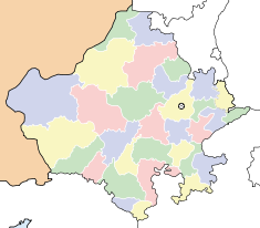
| Mount Abu Rajasthan • India | |
| Coordinates: | |
| Time zone | IST (UTC+5:30) |
| Area • Elevation |
- km² (Expression error: Unexpected round operator. sq mi) • 486 m (1,594 ft) |
| District(s) | Sirohi |
| Population • Density |
- (2005) • - /km² (Expression error: Unexpected * operator. /sq mi) |
| Codes • Pincode • Telephone • Vehicle |
• 307501 • ++02974 • RJ |
Coordinates: Mount Abu is the highest peak in the Aravalli Range of the state of Rajasthan in western India. It is located in the state's Sirohi district. The mountain forms a distinct rocky plateau 22km long by 9 km wide, and the highest peak on the mountain is Guru Shikhar, at 1,722 meters above sea level. It is often referred to as 'an oasis in the desert', as its heights are home to rivers, lakes, waterfalls and evergreen forests, in a region of India which is known for its dry climate and terrain.
History
In the Puranas, the region has been referred to as Arbudaranya, ("forest of Arbhu") and 'Abu' is a dimunitive of this ancient name. It is believed that sage Vasishtha retired to the southern spur at Mount Abu after following his differences with sage Vishvamitra.
Demographics
As of the 2001 Indian census[1], Mount Abu had a total population of 22,045, with males constituting about 58 percent of that total and females comprising about 42 percent. Mount Abu has an average literacy rate of 67 percent, which is higher than the national average of 59.5 percent. The population of the region is weighted towards the youth, with about 14 percent of the population being under 6 years of age.
Tourism
The town of Mount Abu, the only hill station in Rajasthan, is located at an elevation of 1220 meters. It has been a popular retreat from the heat of Rajasthan and neighboring Gujarat for centuries. The Mount Abu Wildlife Sanctuary was established in 1960 and covers 290 km² of the mountain.
Mount Abu is home to a number of Jain temples. The Dilwara Temples are a complex of temples, carved of white marble, that were built between the 11th and 13th centuries AD. The oldest of these is the Vimal Vasahi temple, built in 1031 C.E. by Vimal Shah and dedicated to the first of the Jain Tirthankaras. The Lun Vasahi Temple were built in 1231 C.E. by the brothers Vastupal and Tejpal, who belonged to the Porwal Jain community. They were ministers of Raja Vir Dhawal, a local ruler of Gujarat.
The Achalgarh fort, built in the 14th century by Rana Kumbha of Mewar, stands nearby. It encloses several beautiful Jain temples, including the Achaleswar Mahadev Temple (1412) and the Kantinath Temple (1513).
Nakki Lake is another popular visitor attraction of Mount Abu.There is the Toad Rock on a hill near the lake. Raghunath Temple and Maharaja Jaipur Palace are also on hills near Nakki Lake.
The mountain is also home to several Hindu temples, including the Adhar Devi Temple, carved out of solid rock; the Shri Raghunathji Temple; and a shrine and temple to Dattatreya built atop the Guru Shikhar peak. The world headquarters of the Brahma Kumari order of lady renunciates is also located here, as is the World Spiritual University of the same denomination. There is also believed to be a footprint of Vishnu on top of Mount Abu. The Durga temple, Ambika Mata Temple lies in a cleft of rock in Jagat, just outside of Mount Abu.
Transportation
The nearest railway station is at Abu Road, in the lowlands southeast of the mountain. The station is on the main Indian Railways line between Delhi and Ahmedabad.
Notes
- ↑ Census of India 2001, Retrieved September 16, 2007.
External links
- Government of Rajasthan page on Mount Abu Retrieved December 16, 2007.
- Mount Abu travel guide Retrieved December 16, 2007.
| State of Rajasthan Rajasthan Topics | |
|---|---|
| Capital | Jaipur |
| Divisions | Ajmer | Bharatpur | Bikaner | Jaipur | Jodhpur | Kota | Udaipur |
| Districts | Ajmer | Alwar | Banswara | Baran | Barmer | Bhilwara | Bikaner | Bharatpur | Bundi | Chittorgarh | Churu | Dausa | Dholpur | Dungarpur | Ganganagar | Hanumangarh | Jaipur | Jaisalmer | Jalore | Jhalawar | Jhunjhunu | Jodhpur | Karauli | Kota | Nagaur | Pali | Rajsamand | Sawai Madhopur | Sikar | Sirohi | Tonk | Udaipur |
| Major cities | Alwar • Bhilwara • Bikaner • Jaipur • Jaisalmer • Jodhpur • Udaipur |
Credits
New World Encyclopedia writers and editors rewrote and completed the Wikipedia article in accordance with New World Encyclopedia standards. This article abides by terms of the Creative Commons CC-by-sa 3.0 License (CC-by-sa), which may be used and disseminated with proper attribution. Credit is due under the terms of this license that can reference both the New World Encyclopedia contributors and the selfless volunteer contributors of the Wikimedia Foundation. To cite this article click here for a list of acceptable citing formats.The history of earlier contributions by wikipedians is accessible to researchers here:
The history of this article since it was imported to New World Encyclopedia:
Note: Some restrictions may apply to use of individual images which are separately licensed.

