Difference between revisions of "Mojave Desert" - New World Encyclopedia
(final edit and spell check) |
({{Contracted}}) |
||
| Line 1: | Line 1: | ||
| − | {{Images OK}} {{Claimed}} | + | {{Images OK}}{{Contracted}}{{Claimed}} |
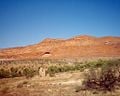
[[Image:Kingston Range from Emigrant Pass.jpg|300px|right|thumb|Looking across from Emigrant Pass towards the [[Kingston Range]] in the eastern Mojave. The [[Old Spanish Trail (trade route)|Old Spanish Trail]] passed through the valley in the foreground.]] | [[Image:Kingston Range from Emigrant Pass.jpg|300px|right|thumb|Looking across from Emigrant Pass towards the [[Kingston Range]] in the eastern Mojave. The [[Old Spanish Trail (trade route)|Old Spanish Trail]] passed through the valley in the foreground.]] | ||
Revision as of 15:59, 6 November 2007

The stunning Mojave Desert extends for over 22,000 square miles in the south western portion of the United States. Crossing into areas of southern California, southwestern Utah, southern Nevada and northwestern Arizona, the extensive desert plays a significant role in shaping the lives of those who call it home.
The term Mojave derives from Mohave tribe of Native Americans that originally inhabited the area. As a tribal name Mohave survives to this day, and still used to refer to native inhabitants of the region. However, the modern Mojave desert extends beyond the traditional tribal boundaries of the Mojave. In modern definitions of the Mojave desert, the desert reaches from the Great Basin Desert to the North to the Sonoran to the south. In terms of latitude, the desert reaches from approximately the 34° line to the 38° line. However, technical definitions of the desert that rely on strict latitude measurements are not considered practical by many people. A simpler, although less scientifically accurate, technique for defining the borders of the desert is the presence of Joshua trees. These unique tree, considered the symbol of the Mojave Desert, have great difficulty in growing outside its borders.
Geography
Natural Features
The Mojave Desert, while bordered by mountain ranges, boasts a relatively small level of altitude change within the desert itself. Most of the area maintains an elevation between 3,000 and 6,000 feet, with notable exceptions at Telescope Peak and Badwater. Both Telescope Peak and Badwater are found within Death Valley National Park, and these geographic features demonstrate the extremes of desert altitude. Telescope Peak towers above its surroundings at a altitude of 11,049 feet, while Badwater dips to an elevation of 282 feet below sea level.
The Mojave Desert is constantly faced with a shortage of water, a situation that threatens existing populations and intimidates future development in the region. Few streams cross the interior of the area, however, the Mojave River in the south provides an important supply of water to the areas surrounding it. Due to the Mojave River, many parts of the desert can receive the water that is necessary for survival. Another important river to the Mojave Desert is the Amargosa River, which flows from the Great Basin Desert to Beatty, Nevada. The Colorado River is also considered to lie within the borders of the Mojave Desert, but due to its location on the edge of the desert, it does not provide a major source of water to the interior.
One of the most unique natural features that is found within the Mojave Desert is the Kelso Sand Dunes, famous both for their beauty and their mysterious formation. These sand dunes, formed primarily out of fine grain residual sand and rose quarts particles, exhibit a distant pink color. Most unusual, however, for a natural geographic feature is that these sand dunes actually create a booming noise. Described by some as a "barking" noise, most scientists feel that the sound is caused by the friction between quartz and feldspar grains of sand. While breathtaking in their modern form, the Kelso sand dunes pose a historical enigma. Research has shown that the sand levels are not being replenished through modern wind currents, posing a question about how the sand dunes came to be formed in the first place. To this end, geologists have proven that the dunes were actually formed through a series of layers 25,000 years ago that built up as a result from climatic change.
Climate
The Mojave Desert is an area of extreme climactic changes, often reaching 120°F in the summer months and dipping to below freezing on winter nights. Unlike many other areas in the southwestern portion of the United States, the Mojave Desert exhibits four distinct seasons that control and shape living conditions in the desert.
Winter
Winters in the Mojave Desert are characterized by freezing nigh time temperatures and occasional rainfall. In the mountain peaks, temperatures during this time can reach 0°F at night. Other areas, including the far reaching valley floors, are more manageable for wildlife, reaching only 20°F in the evening hours. Precipitation during this season is commonly the result of storms that move down into the area from the Pacific Northwest. These storm systems often bring rain, or even snow, to the desert. Despite the rain, however, temperatures during the day can reach 80°F in the time periods between storm systems.
Spring
Spring is time of rejuvenation for the Mojave Desert, when many of the areas becoming blanketed by a rich field of wildflowers. Vegetation growth during spring is possible due to increased rainfall, and less extreme temperature variation than is found during the winter season. Rainfall levels slip into decline beginning in April, with rainfall becoming a rarity as the area enters the summer months.
Summer
The summer months of the Mojave Desert are characterized by a heavy and oppressive heat that settles on the region. The temperatures, sometimes reaching above 120° F are what is generally considered a "dry heat",a coupling of low humidity, low pressure, and high temperatures. This season is also poses the threat of monsoons in the area, which are drawn by the low pressure up from the Gulf of Mexico. The movement of storm systems from the Gulf of Mexico can result in thunderstorms or sporadic rainstorms.
Autumn
Autumns are generally considered the most pleasurable time to visit the Mojave, an opinion which consequentially causes an increase in visitors during the seasons. After the occasional thunderstorms of the summer months, the Mojave settles in a steady weather pattern with less unpredictable showers. Temperatures also experience a slight dip during this season, ranging between 70° F and 90° F on the valley floors.
Vegetation and Wildlife
Human Occupation
The Mojave Desert has proven to be a difficult terrain for human occupation, its harsh weather causing the occupation levels to be relatively low throughout its history. Originally inhabited by the Mohave, the area was largely neglected by outside populations until the discovery of gold and silver deposits in the area. The discovery of these deposits fueled a veritable gold rush, where cities sprouted out over night in an attempt to get rich quick. Mining, however, did not prove as profitable as was expected and many left the newly formed Mojave Desert towns to return to their former homes. The mining cities were abandoned and left to decay in the harsh sun of the Mojave. The most of these ghost towns, Calico, can still be toured by visitors looking to learn more about early mining methods.
Despite its history as a hub of human occupation, the Mojave desert continues to be sparsely inhabited. The interior in particular, where the weather is the most extreme, hosts a very small settled population. On the fringes of the desert, however, modern urban life has made living in the Mojave Desert a palpable possibility for hundreds and thousands of people. The city of Las Vegas, a testament to modern technology, allows 1.9 million people to call the Mojave their home. Smaller urban centers in the desert include: Laughlin, New Mexico, Palmdale, California, and Victorville, California.
Tourism
While the Mojave continues to attract nature lovers for its distinct and breathtaking beauty, most of the visitors to the desert are not seeking the solitude of nature. Las Vegas, an extremely popular gambling and entertainment center, has become the main draw for tourists to the Mojave Desert. The city, which hosts over 3.8 million visitors a year, has become known around the world for its attention to entertainment and legalized gambling.
For the individuals who are not seeking the glittering lights of Las Vegas, four national parks offer the opportunity to explore the unspoiled beauty of the Mojave Desert. Visitors to the area can engage with the desert at Death Valley, Joshua Tree, Zion and Grand Canyon. For the more extreme sports enthusiast, many of the lakes in the desert offer a variety of water sports. Also, many visitors to the sand dunes take advantage of the unique terrain to practice off road driving.

.
Mojave Desert in fiction
The Mojave Desert has captured the imagination of visual and literary artists alike, often serving as a background for books, films, or television shows. The representations of the Mojave range from serving as a backdrop for the Madonna music video "Frozen" to hometown of Captain in the Star Trek series.
Photos from the Mojave Desert
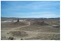
Pinnacles National Natural Landmark
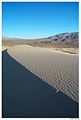
Kelso Sand Dunes
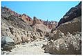
Slot Canyon in Afton Canyon
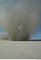
Dust Devil, El Mirage Dry Lake
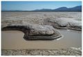
Water hole, Coyote Dry Lake
Rainbow Canyon, near the city of Barstow
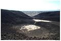
Amboy Crater
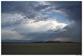
Summer Storm
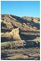
Pioneer cabin remains near St. George, Utah.


See also
- Amboy Crater
- Black Rock Road
- Colorado Desert
- Death Valley and Death Valley National Park
- List of deserts by area
- List of North American deserts
- List of California regions
- Low Desert
- Mojave phone booth
- Mojave Road
- Solar One
- Sonora Desert
- Palen Mountains
- Lake Delores
External links
- Mojave Desert images at bioimages.vanderbilt.edu (slow modem version)
- Off-Road Trails in the Mojave Desert
ReferencesISBN links support NWE through referral fees
- Mojave Desert Wildflowers, Jon Mark Stewart, 1998, pg. iv
- Costantino, Maria. The Illustrated Flag Handbook. Gramercy Books: New York, 2001. ISBN 0517218100
- Lewis, Brenda Ralph. Great Civilizations. Parragon Publishing: Bath, 1999. ISBN 0752561413
- Houk, Rose. Mojave Desert. Palace Press International: China, 2001. ISBN 1583690085
| Deserts |
|---|
| Ad-Dahna | Alvord | Arabian | Aral Karakum | Atacama | Baja California | Barsuki | Betpak-Dala | Chalbi | Chihuahuan | Dasht-e Kavir | Dasht-e Lut | Dasht-e Margoh | Dasht-e Naomid | Gibson | Gobi | Great Basin | Great Sandy Desert | Great Victoria Desert | Kalahari | Karakum | Kyzylkum | Little Sandy Desert | Mojave | Namib | Nefud | Negev | Nubian | Ordos | Owyhee | Qaidam | Registan | Rub' al Khali | Ryn-Peski | Sahara | Saryesik-Atyrau | Sechura | Simpson | Sonoran | Strzelecki | Syrian | Taklamakan | Tanami | Thar | Tihamah | Ustyurt |
Template:California Template:Nevada Template:Arizona
 |
State of Utah Salt Lake City (capital) |
|---|---|
| Topics | Cities |
Counties | Flag | Flower | Governors | Portal | Song |
| Regions | Cache Valley |
Colorado Plateau | Dixie | Great Basin | Great Salt Lake | Great Salt Lake Desert | Mojave Desert | Monument Valley | San Rafael Swell | Uinta Mountains | Wasatch Back | Wasatch Front | Wasatch Range |
|
Largest Cities |
American Fork |
Bountiful | Cedar City | Clearfield | Cottonwood Heights | Draper | Holladay | Kaysville | Layton | Lehi | Logan | Midvale | Murray | Ogden | Orem | Pleasant Grove | Provo | Riverton | Roy | St. George | Salt Lake City | Sandy | South Jordan | South Salt Lake | Spanish Fork | Springville | Taylorsville | Tooele | West Jordan | West Valley City |
| Counties | Beaver |
Box Elder | Cache | Carbon | Daggett | Davis | Duchesne | Emery | Garfield | Grand | Iron | Juab | Kane | Millard | Morgan | Piute | Rich | Salt Lake | San Juan | Sanpete | Sevier | Summit | Tooele | Uintah | Utah | Wasatch | Washington | Wayne | Weber |
| Attractions | Arches National Park |
Bonneville Salt Flats | Bryce Canyon National Park | Canyonlands National Park | Capitol Reef National Park | Great Salt Lake | Ski Areas | Sundance Film Festival | Temple Square | Utah Shakespearean Festival | Zion National Park |
| Colorado River system |
|---|
| Dams and aqueducts (see US Bureau of Reclamation) |
| Shadow Mountain Dam | Granby Dam | Glen Canyon Dam | Hoover Dam | Davis Dam | Parker Dam | Palo Verde Diversion Dam | Imperial Dam | Laguna Dam | Morelos Dam | Colorado River Aqueduct | San Diego Aqueduct | Central Arizona Project Aqueduct | All-American Canal | Coachella Canal | Redwall Dam |
| Natural features |
| Colorado River | Rocky Mountains | Colorado River Basin | Grand Lake | Sonoran desert | Mojave desert | Imperial Valley | Colorado Plateau | Grand Canyon | Glen Canyon | Marble Canyon | Paria Canyon | Gulf of California/Sea of Cortez | Salton Sea |
| Tributaries |
| Dirty Devil River | Dolores River | Escalante River | Gila River | Green River | Gunnison River | Kanab River | Little Colorado River | Paria River | San Juan River | Virgin River |
| Major reservoirs |
| Fontenelle Reservoir | Flaming Gorge Reservoir | Taylor Park Reservoir | Navajo Reservoir | Lake Powell | Lake Mead | Lake Havasu |
| Dependent states |
| Arizona | California | Colorado | Nevada | New Mexico | Utah (See: Colorado River Compact) |
| Designated areas |
| Glen Canyon National Recreation Area | Lake Mead National Recreation Area |
Credits
New World Encyclopedia writers and editors rewrote and completed the Wikipedia article in accordance with New World Encyclopedia standards. This article abides by terms of the Creative Commons CC-by-sa 3.0 License (CC-by-sa), which may be used and disseminated with proper attribution. Credit is due under the terms of this license that can reference both the New World Encyclopedia contributors and the selfless volunteer contributors of the Wikimedia Foundation. To cite this article click here for a list of acceptable citing formats.The history of earlier contributions by wikipedians is accessible to researchers here:
The history of this article since it was imported to New World Encyclopedia:
Note: Some restrictions may apply to use of individual images which are separately licensed.