Lake Ladoga
| Lake Ladoga | |
|---|---|
| Location | Northwestern Russia |
| Coordinates | |
| Primary sources | Svir, Volkhov, Vuoksi |
| Primary outflows | Neva |
| Catchment area | 276,000 km² |
| Basin countries | Russia, Finland |
| Max length | 219 km |
| Max width | 138 km |
| Surface area | 17,700 km² |
| Average depth | 51 m |
| Max depth | 230 m |
| Water volume | 837 km³ |
| Surface elevation | 5 m |
| Islands | about 660 (including Valaam) |
| Settlements | see list |
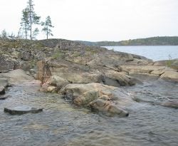
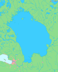
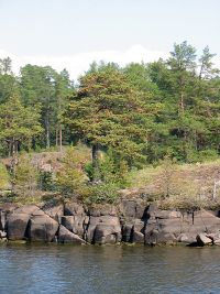
Lake Ladoga, located in the northwestern part of Russia, is the largest lake in all of Europe. The span of the lake is so large that it lies within the borders of two political provinces: the Republic of Karelai and Leningrad Oblast. In total, Lake Ladoga covers an area of 6,700 fresh water square miles, excluding all 660 of the islands on the lake. The width of the lake averages 51 miles, while the length is approximately 136 miles. Along with its impressive size, the lake is also remarkably deep, measuring 167 feet on average. The deepest point of the lake is found just to the west of Valaam Island where the lake dips to 754 feet.
Geography
Lake Ladoga was formed as a result of glacier movements approximately 10,000 years ago. According ot most geologists, the lake was originally part of the Blatic Sea that seperated from the main body of water when the Yoldia Sea began to recede around 8,000 years ago. According to this theory, Lake Ladoga and the Baltic Sea continued to be connected by a small strait untile the River NEva was fully formed. In approximately the 12th century C.E. Lake Ladoga and the Baltic Sea were completely seperated becuase the River Neva was filled with water flowing from Lake Ladoga into the river from the break at Porogi.
The modern form of Lake Ladoga is completely navigable, and serves as an important commercial conduit between the Baltic Sea and the Volga River. In order to facilitate trade along the lake, a canal was built to cut through the southern part of the lake. Ladoga Canal, which connects the Neva to the Svir River, has contributed significantly to commerce by allowing vessels to bypass the southern loop of the lake.
Lake Ladoga is fed by a series of tributaries and smaller rivers in teh Ladoga basin; approximately 3,500 rivers contribute to the water level in the area. In addition, the Svir River, the Volkhov River, the Vuoksi River, and the Syas River discharge into Lake Ladoga. While the flow of water from these rivers helps to keep the water table of Lake Ladoga at an acceptable level for the acquatic ecosystem, precipiation also plays a part in keeping Lake Ladoga full. The lake recieves approximately 13% of its water from precipitation, and while the percentage appears to be low, it would not be able to maintain a steady water level without annual rainfall.
Wildlife
The Ladoga is rich with fish. 48 forms (species and infraspecific taxa) of fish have been encountered in the lake, including roach, carp bream, zander, European perch, ruffe, endemic variety of smelt, two varieties of Coregonus albula (vendace), eight varieties of Coregonus lavaretus, a number of other Salmonidae as well as, albeit rarely, endangered Atlantic sturgeon. Commercial fishing was once a major industry but has been hurt by overfishing. After the war, between 1945–1954, the total annual catch increased and reached a maximum of 4,900 tonnes. However, unbalanced fishery led to the drastic decrease of catch in 1955–1963, sometimes to 1,600 tonnes per year. Trawling has been forbidden in Lake Ladoga since 1956 and some other restrictions were imposed. The situation gradually recovered, and in 1971-1990 the catch ranged between 4,900 and 6,900 tonnes per year, about the same level as the total catch in 1938.[1] Fish farms and recreational fishing are developing. [1]
It has its own endemic Ringed Seal subspecies known as the Ladoga Seal.
Since the beginning of the 1960s Ladoga has become considerably eutrophicated.[2]
Nizhnesvirsky Natural Reserve is situated along the shore of Lake Ladoga immediately to the north of the mouth of the River Svir.
History
In the Middle Ages, the lake formed a vital part of the Trade Route from the Varangians to the Greeks, with the Norse emporium at Staraya Ladoga defending the mouth of the Volkhov since the 8th century. In the course of the Swedish-Novgorodian Wars, the area was disputed between the Novgorod Republic and Sweden. In the early 14th century, the fortresses of Korela (Kexholm) and Oreshek (Nöteborg) were established along the banks of the lake.
The ancient Valaam Monastery was founded on the island of Valaam, the largest in Lake Ladoga, abandoned between 1611–1715, magnificently restored in the 18th century, and evacuated to Finland during the Winter War in 1940. In 1989 the monastic activities in the Valaam were resumed. Other historic cloisters in the vicinity are the Konevets Monastery, which sits on the Konevets island, and the Alexander-Svirsky Monastery, which preserves fine samples of medieval Muscovite architecture.
During the Ingrian War, a fraction of the Ladoga coast was occupied by Sweden. In 1617, by the Treaty of Stolbovo, the northern and western coast was ceded by Russia to Sweden. In 1721, after the Great Northern War, it was restituted to Russia by the Treaty of Nystad. Later, in 1812–1940 the lake was shared between Finland and Russia. According to the conditions of the 1920 Tartu Peace Treaty militarization of the lake was severely restricted. However, both Soviet Russia and Finland had flotillas in Ladoga. After the Winter War (1939-1940) according to the Moscow Peace Treaty, Ladoga, previously shared with Finland, became an internal basin of the Soviet Union.
During the Continuation War (1941-1944) not only Finnish and Soviet, but also German and Italian (see Regia_Marina#Lake_Ladoga) vessels operated there. Under these circumstances, during much of the Siege of Leningrad (1941–1944), Lake Ladoga provided the only access to the besieged city. Supplies were transported into Leningrad with trucks on winter roads over the ice, the "Road of Life", and by boat in the summer. After the World War II, Finland lost the Karelia region to the USSR, and all Finnish citizens were evacuated from the ceded territory. Ladoga became an internal Soviet basin again. The nortern shore, Ladoga Karelia with the town of Sortavala, is now part of the Republic of Karelia. The western shore, Karelian Isthmus, became part of Leningrad Oblast.
Notes
- ↑ Kudersky, Leonid K. et al. (1996). Fishery of Lake Ladoga — past, present and future. Hydrobiologia 322.1-3, 57-64.
- ↑ Holopainen, Anna-Liisa et al. (1996) The trophic state of Lake Ladoga as indicated by late summer phytoplankton. Hydrobiologia 322.1-3, 9-16.
ReferencesISBN links support NWE through referral fees
- Butler, Sue. 1998. Via Leeds to Lake Ladoga. Bradford: Redbeck Press. ISBN 9780946980642
- Viljanen, Markku. 2004. Sustainable use, management and monitoring of fish resources in Lake Ladoga. Karjalan tutkimuslaitoksen raportteja, n:o 4/2004. [Joensuu]: Joensuun yliopisto. ISBN 9789524585019
External links
- Simola, Heikki et al. (eds), Proceeding of The First International Lake Ladoga Symposium. Special issue of Hydrobiologia. Vol. 322, Issues 1-3. / April 1996.
- The Ladoga Lake (photos)
- War on Lake Ladoga, 1941-1944
- Maps
Credits
New World Encyclopedia writers and editors rewrote and completed the Wikipedia article in accordance with New World Encyclopedia standards. This article abides by terms of the Creative Commons CC-by-sa 3.0 License (CC-by-sa), which may be used and disseminated with proper attribution. Credit is due under the terms of this license that can reference both the New World Encyclopedia contributors and the selfless volunteer contributors of the Wikimedia Foundation. To cite this article click here for a list of acceptable citing formats.The history of earlier contributions by wikipedians is accessible to researchers here:
The history of this article since it was imported to New World Encyclopedia:
Note: Some restrictions may apply to use of individual images which are separately licensed.


