Difference between revisions of "Kathmandu" - New World Encyclopedia
Mike Butler (talk | contribs) |
Mike Butler (talk | contribs) |
||
| Line 157: | Line 157: | ||
In the fourth century, the region became a puppet state under the [[Gupta Civilization|Gupta Dynasty]] (280 to 550 C.E.) | In the fourth century, the region became a puppet state under the [[Gupta Civilization|Gupta Dynasty]] (280 to 550 C.E.) | ||
| − | From the late fifth century, rulers called ''the Licchavis'' governed the area | + | From the late fifth century, rulers called ''the Licchavis'', whose earliest inscriptions date back to 464 C.E., governed the area. |
| − | By the late 11th century, southern Nepal came under the influence of the Chalukya Empire, | + | The [[Malla (Nepal)|Malla Dynasty]] consisted of [[Newar]] rulers, who ruled Kathmandu Valley and the surrounding area from from 879, till the [[17th century|17<sup>th</sup> century]] |
| + | |||
| + | By the late 11th century, southern Nepal came under the influence of the Chalukya Empire, an Indian royal dynasty that ruled large parts of southern and central India between the 6th and the 12th centuries. From then, [[Hinduism]] prevailed over [[Buddhism]] in southern Nepal. | ||
Thirteenth-century Nepal was pillaged by the Delhi Sultanate of northern India. King Jayasthitimalla united most of the country by the late fourteenth century, but in 1482 the kingdom was carved into three smaller areas: Kathmandu, Patan, and Bhadgaon. | Thirteenth-century Nepal was pillaged by the Delhi Sultanate of northern India. King Jayasthitimalla united most of the country by the late fourteenth century, but in 1482 the kingdom was carved into three smaller areas: Kathmandu, Patan, and Bhadgaon. | ||
| − | Modern Nepal was created in the latter half of the eighteenth century when Prithvi Narayan Shah, the ruler of the small principality of Gorkha, united a number of independent hill states to form the Gorkha Kingdom. He conquered the Kathmandu valley in 1768. | + | Modern Nepal was created in the latter half of the eighteenth century when Prithvi Narayan Shah (1723-1775), the ruler of the small principality of Gorkha, united a number of independent hill states to form the Gorkha Kingdom. He conquered the Kathmandu valley in 1768. Most of ancient [[Nepali Architecture]] present in [[Nepal]] today is from the [[Malla]]/[[Newar]] era. |
| + | |||
| + | Rivalry with the [[British East India Company]] over the annexation of minor states bordering Nepal led to the brief but bloody Anglo-Nepalese War (1815-1816), in which Nepal defended its present-day borders but lost territories west of the Kali River | ||
| − | |||
| − | |||
In 1951, the Nepalese monarch ended the century-old system of rule by hereditary premiers and instituted a cabinet system of government. | In 1951, the Nepalese monarch ended the century-old system of rule by hereditary premiers and instituted a cabinet system of government. | ||
Revision as of 23:10, 12 December 2008
| Kathmandu Metropolitan City येँ महानगरपालिका ñē̆ dēy (ञेँ देय्) Kantipur |
|
 |
|
 Kathmandu Metropolitan City |
|
| Coordinates: 27°42′N 85°20′E | |
|---|---|
| Country | Nepal |
| Development Region | Central |
| Zone | Bagmati |
| District | Kathmandu |
| Established | 723 [1] |
| Government | |
| - Prime Minister | Pushpa Kamal Dahal 'Prachanda'[1] |
| Area | |
| - Total | 50.67 km² (19.6 sq mi) |
| Population (2001) | |
| - Total | 671,846 |
| Time zone | GMT +5:45 (UTC) |
| Website: http://www.kathmandu.gov.np/ | |
Kathmandu (Nepali: काठमांडौ, Nepal Bhasa: येँ) is the capital and the largest city of Nepal. The city is situated in the World Heritage Site Kathmandu Valley, that also contains two other cities - Patan and Bhaktapur.
Considered by some to be among the most beautiful cities in the world, Kathmandu is the most developed city in Nepal.
Geography
The city of Kathmandu is named after a structure in Durbar Square called Kaasthamandap. In Sanskrit, Kaasth (काष्ठ) is "wood" and Mandap (मंडप/मण्डप) is "covered shelter." This unique temple, also known as Maru Sattal, was built in 1596 C.E. by King Laxmi Narsingh Malla. The entire structure contains no iron nails or supports and is made entirely from wood. Legend has it that the timber used for this two story pagoda was obtained from a single tree.
Kathmandu is also sometimes called "Kantipur". Kanti is an alternate name of the Goddess Laxmi, and Pur meants the place where such a goddess resides; thus, the name Kantipur demonstrates the ancient belief that it is the place where Laxmi dwells. Newars, the native people of the Kathmandu valley use the original term from Nepal Bhasa, Yne.
The city is located in the northwestern part of Kathmandu Valley. The Kathmandu Valley covers an area of 218 sq. miles. Bagmati, Bishnumati, Dhobikhola, and Tukucha rivers wind through the city.
The city stands at an elevation of approximately 4500 feet (1400 meters).
The Kathmandu Valley has a mild climate most of the year. The average maximum daytime temperature in January is 64.4°F (18°C), rising to an average maximum of around 84.2°F (29°C) in July. During the rainy monsoon season between June and August, there is an average rainfall of between 7.8-14.7 inches (200-375mm) in Kathmandu. May and June can be very hot and humid until the monsoon rains bring relief. In spring (March to April) and autumn (October to November) the temperatures are pleasant with occasional short bursts of rain, while November to February is dry, but can be very cold, especially at night. Mean annual precipitation is 56.18 inches (1427mm).
Size – land area, size comparison
Environmental issues include deforestation, from the overuse of wood for fuel and lack of alternatives; water contaminated with human and animal wastes, agricultural runoff, and industrial effluents; and vehicular emissions.
Districts
History


Kathmandu is situated in the heart of the Himalaya mountains, and has a rich history.
Neolithic tools found in the Kathmandu Valley indicate that people have been living in the Himalayan region for at least 9,000 years. People who were probably of Tibeto-Burman ethnicity lived in Nepal 2,500 years ago.
Indo-Aryan tribes entered the valley around 1500 B.C.E. Around 1000 B.C.E., small kingdoms and confederations of clans arose.
The Kirats, believed to date to before the 9th century B.C.E., are the first documented rulers of Kathmandu Valley. The remains of their palace are in Patan near kendra Hiranyavarna Mahavihara (called "Patukodon"). For over a millennium, the Kirat had also inhabited the Kathmandu Valley, where they installed their own ruling dynasty.
Siddhartha Gautama (563–483 B.C.E.), a prince of the Shakya confederation, renounced his royalty to lead an ascetic life and came to be known as the Buddha ("the one who has awakened").
By 250 B.C.E., the region came under the influence of the Mauryan empire (322–185 B.C.E.), of northern India.
The oldest firmly dated building in the earthquake-prone valley is almost 1992 years old, and the earliest known inscription in the Kathmandu Valley is dated 185 C.E.
In the fourth century, the region became a puppet state under the Gupta Dynasty (280 to 550 C.E.)
From the late fifth century, rulers called the Licchavis, whose earliest inscriptions date back to 464 C.E., governed the area.
The Malla Dynasty consisted of Newar rulers, who ruled Kathmandu Valley and the surrounding area from from 879, till the 17th century
By the late 11th century, southern Nepal came under the influence of the Chalukya Empire, an Indian royal dynasty that ruled large parts of southern and central India between the 6th and the 12th centuries. From then, Hinduism prevailed over Buddhism in southern Nepal.
Thirteenth-century Nepal was pillaged by the Delhi Sultanate of northern India. King Jayasthitimalla united most of the country by the late fourteenth century, but in 1482 the kingdom was carved into three smaller areas: Kathmandu, Patan, and Bhadgaon.
Modern Nepal was created in the latter half of the eighteenth century when Prithvi Narayan Shah (1723-1775), the ruler of the small principality of Gorkha, united a number of independent hill states to form the Gorkha Kingdom. He conquered the Kathmandu valley in 1768. Most of ancient Nepali Architecture present in Nepal today is from the Malla/Newar era.
Rivalry with the British East India Company over the annexation of minor states bordering Nepal led to the brief but bloody Anglo-Nepalese War (1815-1816), in which Nepal defended its present-day borders but lost territories west of the Kali River
In 1951, the Nepalese monarch ended the century-old system of rule by hereditary premiers and instituted a cabinet system of government.
Kathmandu has been popular with western tourists since the 1960's when it became a key stop on the Hippy Trail, when Jho: Chheen (Nepal Bhasa, continuous house)(Freak Street) was the one of the main location. It is also the subject of a popular Bob Seger song for the same reason. It is rumoured that many rock singers used to visit Jho: Cheen and downtown Kathmandu in search of tranquility and Nirvana.
Reforms in 1990 established a multiparty democracy within the framework of a constitutional monarchy.
An insurgency led by Maoist extremists broke out in 1996. The ensuing nine-year civil war between insurgents and government forces witnessed the dissolution of the cabinet and parliament and assumption of absolute power by the king.
Several weeks of mass protests in April 2006 were followed by several months of peace negotiations between the Maoists and government officials, and culminated in a November 2006 peace accord and the promulgation of an interim constitution.
The newly formed interim parliament declared Nepal a democratic federal republic at its first meeting in May 2008, the king vacated the throne in mid-June 2008, and parliament elected the country's first president the following month.
Government

Nepal is a democratic republic in which the chief of state is the president, who is elected by Parliament, and the head of government is the prime minister. The unicameral Constituent Assembly has 601 seats, of which 240 are decided by direct popular vote, 335 by proportional representation, and 26 are appointed by the cabinet (Council of Ministers))
Nepal is divided into 14 zones and 75 districts, grouped into five development regions. Each district is headed by a permanent chief district officer responsible for maintaining law and order and coordinating the work of field agencies of the various government ministries.
The Kathmandu Valley, with its conurbation of 1.5 million inhabitants, is located in the Bagmati Zone, named after the river Bagmati, which is in Central Development Region of Nepal.
Kathmandu City is the headquaters of the Kathmandu District
Kathmandu city is looked after by Kathmandu metropolitan office located at Bagdarbar. The city hosts Singha Darbar, the government seat of Nepal (with the office of Prime Minister, Supreme Court and Senate). Most of the ministries are present in the Singha Darbar premises. The Royal Palace is located in central part of city.
The metropolitan area has been divided into five sectors and 35 wards.
Economy
Nepal is among the poorest and least developed countries in the world with almost one-third of its population living below the poverty line. Agriculture is the mainstay of the economy, providing a livelihood for three-fourths of the population and accounting for 38 percent of GDP. Industrial activity mainly involves the processing of agricultural produce including jute, sugarcane, tobacco, and grain. Per capita GDP was estimated at $1000 in 2007.
Being the capital city of Nepal, Kathmandu is home to most of the government offices, embassies, corporate houses, and the palace. Most of the offices and industry of Nepal are in Kathmandu. Many students from all over Nepal come to Kathmandu to have higher Secondary Education (+2 Level).
Financial and business services sector
Tourism
Manufacturing
Transport: Road, rail, air, sea
The city is a hub for Germany’s and Europe’s high-speed passenger rail network.
Autobahns radiate from Cologne's ring road.
Tribhuvan International Airport is located about 25 km from the city center, offering domestic and international flights.
Public transport within the city includes buses, a subway system, and the Rheinseilbahn aerial tramway crossing the Rhine.
Kathmandu houses most of the banks, business houses, offices, organizations and share market of Nepal. The busiest economic centers are New Road of Kathmandu, Ason, Putalisadak and Darbar Marg. New Road is regarded as financial hub with presence of most of the banks in this street.
Freak Street and Thamel are main tourist areas important for tourism.
Demographics
and is inhabited by about 700,000 people.
Race/ethnicity - historical background of ethnic groups
The last name of Gautam is quite famous in Kathmandu.
Nepali is the lingua franca of the valley and is the most widely spoken language. Nepal Bhasa/Newari is the language spoken by native people, the Newars. Hindi and English are understood by most of the educated population of the city.
Religion
The Kathmandu District itself is known as the city of temples, attracting Hindu people and those who have interest on others’ religion.
Nepal University (formerly called Tribhuvan University) is the only university in Kathmandu. Established in 1959, and with approximately 272,746 students, it the biggest university in Nepal.
According to 2001 census, there are 235,387 households in the metropolitan city[2]. Kathmandu metropolitan authorities estimate the number of people living in the city to be around 1,081,845 people [3] The largest ethnic groups are Newars, Brahmins and Kshetris. The major languages are Nepali and Nepal Bhasa. The major religions are Hinduism and Buddhism.
Of interest


Thamel has been the centre of the tourist industry in Kathmandu for over two decades, growing up between two of the original hotels, the Kathmandu Guesthouse and Hotel Uste. Even though Thamel has been referred to as the "ghetto" by some, most low-budget travelers consider it a tourist haven. Ason Bazaar, Durbar Square, Samakushi and Swayambhunath are a mere 10 to 30 minutes walk from Thamel, which has a vibrant ethnic culture practised by its core population of the Newar people. Hashish sellers openly approach in the streets. Thamel also acts as the pre-base camp for mountaineers. It boasts a wide range of mountaineering gear shops, foreign money exchange booths, pubs, clubs and nightlife along with the innumerous travel lodges and guest houses. Other sites of interest include:
- The old palace of Newar kings.
- Kathmandu Durbar Square, which is listed as UNESCO world heritage site, is in Basantapur, is the most extensive of the three royal palace valley squares in the Kathmandu Valley. It contains 60 important historic buildings from the 17th and 18th centuries. It's main building, Taleju Bhawani Temple, was built in 1576.
- Swayambhunath, situated on a hilltop two miles west of Kathmandu town, is the oldest Bhuddist monument in the Kathmandu Valley. It is also known as the Monkey Temple as there are holy monkeys living in parts of the temple in the north-west. The Swayambhunath complex consists of a stupa, a variety of shrines and temples, including a Tibetan monastery, a museum and a library. The stupa has Buddha's eyes and eyebrows painted on. Between them, there is something painted which looks like the nose - but is the Nepali symbol of 'unity', in the main Nepali language dialect. There are also shops, restaurants and hostels.
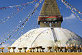
- Bauddhanath, located eight kilometers west of Kathmandu city, is the largest Bhuddist stupa in Nepal. On top of the dome is a square tower covered with gilded brass sheets on which are painted faces of the eternal, all-seeing Buddha. The stupa originated in the fifth century but has been repeatedly added to.
- Freak Street was the popular hippie spot during the seventies.
- The Shah King's Palace stands right next to Thamel - the tourist hub of the country. A small world within itself, Thamel is famous for the most attractive hotels and shopping centers in the world. It consists of two parallel streets just to the west of the palace. It is home to world famous hotels, ranging from different stars. The palace is at the head of Durbar Marg, a street lined with various shops. Most of the streets in Kathmandu are named from Nepal Bhasa, owing its origin to the rich Newari Culture and heritage. In a sense, Kathmandu is the most read text in the field of culture, history and Newari civilization in South Asia.
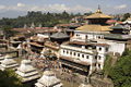
The "old" city is noted for its many Buddhist and Hindu temples and palaces, most dating to the 17th century. Many of these landmarks have been damaged by earthquakes and pollution. This valley hosts an UNESCO World Heritage Sites composed by seven different Monument Zones: The centers of the three primary cities, Kathmandu Hanuman Dhoka, Patan and Bhaktapur, the two most important Buddhist stupas, Swayambhunath and Boudhanath and two famous Hindu shrines, Pashupatinath temple and Changu Narayan. Since 2003 the site has been inscribed in the World Heritage List as being "in danger" out of concern for the ongoing loss of authenticity and the outstanding universal value of the cultural property.
Cultural impact
The city has been referenced in numerous songs, including works by Cat Stevens ("Katmandu", Mona Bone Jakon (1970)), Bob Seger ("Katmandu", Beautiful Loser (1975)), Krematorij ("Kathmandu", Three Springs (2000)), Fito Páez ("Tráfico por Katmandú" — "Traffic through Kathmandu"); Will Ackerman ("A Happy Home in Kathmandu", The Opening of Doors (1993)); Tantra ("The Hills of Katmandu", early 1980s); and Godiego ("Coming Together in Kathmandu" (1980).
Numerous works of literature have been set in Kathmandu, including Kim Stanley Robinson's 1989 work, Escape from Kathmandu. Recently, the book ("Arresting God in Kathmandu") by Samrat Upadhyay has got international acclaim.
In some travelogues, the Kathmandu valley has been referred to as the "Emerald Valley".
The location is mentioned in the film Bewitched as the title of a fictional movie Will Ferrell's character stars in prior to his role in the Bewitched remake.
Gallery
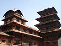
The palace in the Kathmandu Durbar Square.
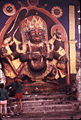
Bhairava sculpture, Durbar Square market place 1972.
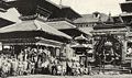
A view of Kathmandu Durbar Square from 1920. Bhairava in the background.
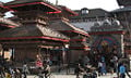
Same as the picture to the left but from 2007, shot for comparison.
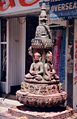
Small stupa in Kathmandu
Stone carving in Kathmandu street
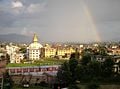
View over Kathmandu
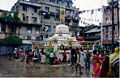
A seller warming himself up in Durbar Square, Kathmandu, Nepal (pre-prohibition)
Boudhanath Stupa in Kathmandu, Nepal
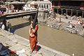
Pashupatinath Temple in Kathmandu, Nepal
Pashupatinath temple in Kathmandu, Nepal
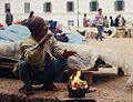
Rickshaw driver in Kathmandu near Durbar Square


Kathmandu in Popular Music
Kathmandu, mostly due to its popularity among Hippies, has been represented in various albums and songs including:
- Kathmandu, a song by Bob Seger.
- "Dum Maro Dum", a song in the movie, Hare Rama Hare Krishna by Asha Bhosle.
- "Our Shangrila", a song by Mark Knopfler.
- "Shangrila", a song by The Kinks.
- Kathmandu, a song by Cat Stevens.
- Tráfico por Kathmandú by Fito Páez.
- Kathmandu, an American heavy metal band featuring Dave King and Mandy Meyer.
- Nobody Told Me, a 1984 song by John Lennon with the line "There's a little yellow idol to the north of Kathmandu". This is a quotation from the 1911 poem "The Green Eye of the Yellow God" by John Milton Hayes.
- "A Passage to Bangkok", a song by Rush from the album 2112. "...Pulling into Kathmandu, smoke rings fill the air. Perfumed by a Nepal night, the Express gets you there..."
See also
- Tribhuvan International Airport
- Kathmandu Valley
Footnotes
- ↑ 1.0 1.1 Census Nepal 2001. Retrieved July 13, 2007. Cite error: Invalid
<ref>tag; name "Citydata" defined multiple times with different content - ↑ Census Nepal 2001. Retrieved July 13, 2007.
- ↑ National Report 2001
Further reading
- Bindloss, Joseph. 2006. Kathmandu. Lonely Planet citiescape Asia. Footscray, Vic: Lonely Planet. ISBN 9781741049398
- Choegyal, Lisa. 1992. Kathmandu. Insight city guides. Singapore: Apa Publications.
- "NEPAL: The Mad Prince of Kathmandu - A royal squabble over marriage leads to a massacre of the ruling family in the Himalayan kingdom". 2001. Time. 32. OCLC 93064974
- Shrestha, Dinesh. 2007. Timeless Kathmandu. Kathmandu: Himalayan MapHouse. ISBN 9789993347255
- Thapa, R. B., Y. Murayama, and S. Ale. 2008. "Kathmandu". Cities. 25 (1): 45-57. OCLC 212730484
- Willesee, Amy, and Mark Whittaker. 2004. Love & death in Kathmandu: a strange tale of royal murder. New York: St. Martin's Press. ISBN 9780312329945
External links
- Travel guide to Kathmandu from Wikitravel
- Encyclopaedia Britannica Kathmandu Retrieved December 10, 2008.
- World Fact Book 2008 Nepal Retrieved December 10, 2008.
- Kathmandu climate Retrieved December 10, 2008.
- Explore and discover Kathmandu on a digital Map
- Information on Cultural Heritage in Kathmandu With Pictures
- Flickr.com - Sights & Scenes from Kathmandu
- Weather in Kathmandu and more
Credits
New World Encyclopedia writers and editors rewrote and completed the Wikipedia article in accordance with New World Encyclopedia standards. This article abides by terms of the Creative Commons CC-by-sa 3.0 License (CC-by-sa), which may be used and disseminated with proper attribution. Credit is due under the terms of this license that can reference both the New World Encyclopedia contributors and the selfless volunteer contributors of the Wikimedia Foundation. To cite this article click here for a list of acceptable citing formats.The history of earlier contributions by wikipedians is accessible to researchers here:
The history of this article since it was imported to New World Encyclopedia:
Note: Some restrictions may apply to use of individual images which are separately licensed.