Difference between revisions of "Allegheny River" - New World Encyclopedia
(spellchecked ready tag applied) |
Mary Anglin (talk | contribs) m |
||
| Line 6: | Line 6: | ||
| mouth = [[Ohio River]] | | mouth = [[Ohio River]] | ||
| basin_countries = [[USA]] | | basin_countries = [[USA]] | ||
| − | | length = | + | | length = 325 miles (523 km) |
| − | | elevation = ~2, | + | | elevation = ~2,490 feet (759 m) |
| − | | discharge = 16, | + | | discharge = 16,700 cubic feet/s (1,503 m³/s) at [[Natrona, Pennsylvania|Natrona]] |
| − | | watershed = 11, | + | | watershed = 11,580 square miles (29,992 km²) |
}} | }} | ||
{{ImageStackRight|310| | {{ImageStackRight|310| | ||
| Line 18: | Line 18: | ||
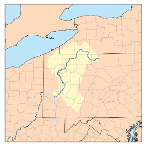
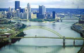
The '''Allegheny River''' (also spelled '''Allegany River''', especially in [[New York]] [[U.S. state|state]]{{Fact|date=February 2007}}) is a principal [[tributary]] of the [[Ohio River]] and is located in the eastern [[United States]]. It forms the Ohio with the [[Monongahela River]] at downtown [[Pittsburgh, Pennsylvania|Pittsburgh]]'s "The Point" at [[Point State Park]]. | The '''Allegheny River''' (also spelled '''Allegany River''', especially in [[New York]] [[U.S. state|state]]{{Fact|date=February 2007}}) is a principal [[tributary]] of the [[Ohio River]] and is located in the eastern [[United States]]. It forms the Ohio with the [[Monongahela River]] at downtown [[Pittsburgh, Pennsylvania|Pittsburgh]]'s "The Point" at [[Point State Park]]. | ||
| − | The river is approximately | + | The river is approximately 325 mi (523 km) long, running through the [[U.S. state]]s of [[New York]] and [[Pennsylvania]]. It drains a rural [[dissected plateau]] of 11,580 sq mi (29,992 km²) in the northern [[Allegheny Plateau]], providing the northeastern most drainage in the watershed of the [[Mississippi River]]. Its tributaries reach to within 8 mi (13 km) of [[Lake Erie]] in southwestern New York. The valley of the river has been one of the most productive areas of energy extraction in U.S. history, with extensive deposits of [[coal]], [[petroleum]], and [[natural gas]]. The word "Allegheny" comes from the [[Lenape]] (Delaware) Indians. Although it is usually translated as "fine river," the meaning is not definitively known. There is a Lenape legend of a tribe called "Allegewi" who used to live along the river. Other Indians, such as the [[Iroquois]], considered the Allegheny and Ohio rivers as the same, as is suggested by a New York State road sign on [[Interstate 86 (east)|Interstate 86]] that refers to the Allegheny river secondarily as "O Hi Yo."<ref>[[George R. Stewart|Stewart, George R.]] (1967, pg. 8) Names on the Land. Boston: Houghton Mifflin Company.</ref> |
==Course== | ==Course== | ||
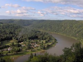
| − | The Allegheny rises in north central Pennsylvania, in central [[Potter County, Pennsylvania|Potter County]], approximately | + | The Allegheny rises in north central Pennsylvania, in central [[Potter County, Pennsylvania|Potter County]], approximately 10 mi (16 km) south of the New York border. It flows west past [[Coudersport, Pennsylvania|Coudersport]] then turns north into western New York State, looping westward across southern [[Cattaraugus County, New York|Cattaraugus County]] for approximately 30 mi (48 km), past [[St. Bonaventure University]] and [[Salamanca, New York|Salamanca]] and forming the northern boundary of [[Allegany State Park]] before re-entering northwestern Pennsylvania approximately 20 mi (32 km) southeast of [[Jamestown, New York]]. |
It flows in a broad zigzag course generally southward across western Pennsylvania, first flowing southwest past [[Warren, Pennsylvania|Warren]], [[Oil City, Pennsylvania|Oil City]], and [[Franklin, Pennsylvania|Franklin]], forming much of the northwestern boundary of [[Allegheny National Forest]]. South of Franklin it turns southeast across [[Clarion County, Pennsylvania|Clarion County]] in a [[meander]]ing course, then turns again southwest across [[Armstrong County, Pennsylvania|Armstrong County]], flowing past [[Kittanning, Pennsylvania|Kittanning]], [[Ford City, Pennsylvania|Ford City]], Clinton and [[Freeport, Pennsylvania|Freeport]]. It enters the [[Pittsburgh, Pennsylvania|Pittsburgh]] suburbs and the City of Pittsburgh from the northeast passing Karns & Natrona in Harrison Township, Braeburn, Lower Burrell, Brackenridge, Tarentum, Creighton, Arnold, New Kensington, Springdale, Harmarville, Blawnox, Fox Chapel, Sharpsburg, Etna, Millvale, Lawrenceville, Highland Park, The North Side, Downtown Pittsburgh, Point State Park and joins with the [[Monongahela River]] at "The Point" in Downtown Pittsburgh, Pennsylvania to form the [[Ohio River]], which flows via the [[Mississippi River]] into the [[Gulf of Mexico]]. | It flows in a broad zigzag course generally southward across western Pennsylvania, first flowing southwest past [[Warren, Pennsylvania|Warren]], [[Oil City, Pennsylvania|Oil City]], and [[Franklin, Pennsylvania|Franklin]], forming much of the northwestern boundary of [[Allegheny National Forest]]. South of Franklin it turns southeast across [[Clarion County, Pennsylvania|Clarion County]] in a [[meander]]ing course, then turns again southwest across [[Armstrong County, Pennsylvania|Armstrong County]], flowing past [[Kittanning, Pennsylvania|Kittanning]], [[Ford City, Pennsylvania|Ford City]], Clinton and [[Freeport, Pennsylvania|Freeport]]. It enters the [[Pittsburgh, Pennsylvania|Pittsburgh]] suburbs and the City of Pittsburgh from the northeast passing Karns & Natrona in Harrison Township, Braeburn, Lower Burrell, Brackenridge, Tarentum, Creighton, Arnold, New Kensington, Springdale, Harmarville, Blawnox, Fox Chapel, Sharpsburg, Etna, Millvale, Lawrenceville, Highland Park, The North Side, Downtown Pittsburgh, Point State Park and joins with the [[Monongahela River]] at "The Point" in Downtown Pittsburgh, Pennsylvania to form the [[Ohio River]], which flows via the [[Mississippi River]] into the [[Gulf of Mexico]]. | ||
==Tributaries== | ==Tributaries== | ||
| − | In its upper reaches the Allegheny is joined from the south by [[Potato Creek]] in [[McKean County, Pennsylvania]] and from the north by [[Olean Creek]] at [[Olean, New York]]. The [[Great Valley, New York|Great Valley Creek]] and [[Little Valley, New York|Little Valley Creek]] join the river from the north in [[Salamanca, New York]] before becoming the [[Allegheny Reservoir]]. After re-entering Pennsylvania, it is joined from the east by [[Kinzua Creek]] | + | In its upper reaches the Allegheny is joined from the south by [[Potato Creek]] in [[McKean County, Pennsylvania]] and from the north by [[Olean Creek]] at [[Olean, New York]]. The [[Great Valley, New York|Great Valley Creek]] and [[Little Valley, New York|Little Valley Creek]] join the river from the north in [[Salamanca, New York]] before becoming the [[Allegheny Reservoir]]. After re-entering Pennsylvania, it is joined from the east by [[Kinzua Creek]] 10 mi (16 km) upstream of Warren; from the north by [[Conewango Creek]] at Warren; from the west by [[Brokenstraw Creek (Allegheny River)|Brokenstraw Creek]]; from the north by [[Oil Creek (Allegheny River)|Oil Creek]] at Oil City; from the west by [[French Creek (Allegheny River)|French Creek]] at Franklin; from the east by the [[Clarion River]] in [[Parker, Pennsylvania]], one of its principal tributaries, in eastern Clarion County; from the east by [[Crooked Creek (Pennsylvania)|Crooked Creek]] southeast of Kittanning; and from the east by the [[Kiskiminetas River]], another principal tributary, at [[Freeport, Pennsylvania|Freeport]]. |
Buffalo Creek enters at Freeport, Bull Creek enters at Tarentum. There are many other creeks, runs and streams that enter or join with the Allegheny River. | Buffalo Creek enters at Freeport, Bull Creek enters at Tarentum. There are many other creeks, runs and streams that enter or join with the Allegheny River. | ||
| Line 99: | Line 99: | ||
==Notes== | ==Notes== | ||
| − | + | <references/> | |
| − | |||
==References== | ==References== | ||
Revision as of 01:35, 19 July 2008
| Allegheny River | |
|---|---|
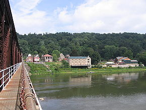
| The Allegheny River at Pittsburgh, Pennsylvania | |
| Origin | Raymond, PA |
| Mouth | Ohio River |
| Basin countries | USA |
| Length | 325 miles (523 km) |
| Source elevation | ~2,490 feet (759 m) |
| Avg. discharge | 16,700 cubic feet/s (1,503 m³/s) at Natrona |
| Basin area | 11,580 square miles (29,992 km²) |
The Allegheny River (also spelled Allegany River, especially in New York state[citation needed]) is a principal tributary of the Ohio River and is located in the eastern United States. It forms the Ohio with the Monongahela River at downtown Pittsburgh's "The Point" at Point State Park.
The river is approximately 325 mi (523 km) long, running through the U.S. states of New York and Pennsylvania. It drains a rural dissected plateau of 11,580 sq mi (29,992 km²) in the northern Allegheny Plateau, providing the northeastern most drainage in the watershed of the Mississippi River. Its tributaries reach to within 8 mi (13 km) of Lake Erie in southwestern New York. The valley of the river has been one of the most productive areas of energy extraction in U.S. history, with extensive deposits of coal, petroleum, and natural gas. The word "Allegheny" comes from the Lenape (Delaware) Indians. Although it is usually translated as "fine river," the meaning is not definitively known. There is a Lenape legend of a tribe called "Allegewi" who used to live along the river. Other Indians, such as the Iroquois, considered the Allegheny and Ohio rivers as the same, as is suggested by a New York State road sign on Interstate 86 that refers to the Allegheny river secondarily as "O Hi Yo."[1]
Course
The Allegheny rises in north central Pennsylvania, in central Potter County, approximately 10 mi (16 km) south of the New York border. It flows west past Coudersport then turns north into western New York State, looping westward across southern Cattaraugus County for approximately 30 mi (48 km), past St. Bonaventure University and Salamanca and forming the northern boundary of Allegany State Park before re-entering northwestern Pennsylvania approximately 20 mi (32 km) southeast of Jamestown, New York.
It flows in a broad zigzag course generally southward across western Pennsylvania, first flowing southwest past Warren, Oil City, and Franklin, forming much of the northwestern boundary of Allegheny National Forest. South of Franklin it turns southeast across Clarion County in a meandering course, then turns again southwest across Armstrong County, flowing past Kittanning, Ford City, Clinton and Freeport. It enters the Pittsburgh suburbs and the City of Pittsburgh from the northeast passing Karns & Natrona in Harrison Township, Braeburn, Lower Burrell, Brackenridge, Tarentum, Creighton, Arnold, New Kensington, Springdale, Harmarville, Blawnox, Fox Chapel, Sharpsburg, Etna, Millvale, Lawrenceville, Highland Park, The North Side, Downtown Pittsburgh, Point State Park and joins with the Monongahela River at "The Point" in Downtown Pittsburgh, Pennsylvania to form the Ohio River, which flows via the Mississippi River into the Gulf of Mexico.
Tributaries
In its upper reaches the Allegheny is joined from the south by Potato Creek in McKean County, Pennsylvania and from the north by Olean Creek at Olean, New York. The Great Valley Creek and Little Valley Creek join the river from the north in Salamanca, New York before becoming the Allegheny Reservoir. After re-entering Pennsylvania, it is joined from the east by Kinzua Creek 10 mi (16 km) upstream of Warren; from the north by Conewango Creek at Warren; from the west by Brokenstraw Creek; from the north by Oil Creek at Oil City; from the west by French Creek at Franklin; from the east by the Clarion River in Parker, Pennsylvania, one of its principal tributaries, in eastern Clarion County; from the east by Crooked Creek southeast of Kittanning; and from the east by the Kiskiminetas River, another principal tributary, at Freeport. Buffalo Creek enters at Freeport, Bull Creek enters at Tarentum. There are many other creeks, runs and streams that enter or join with the Allegheny River.
History
In the 16th century, control of the river valley passed back-and-forth between Algonquian-speaking Shawnee and the Iroquois. By the time of the arrival of the French in the early 18th century, the Shawnee were once again in control and formed an alliance with the French against the incursion of British settlement across the Allegheny Mountains. The conflict over the expansion of British settlement into the Allegheny Valley and the surrounding Ohio Country was a primary cause of the French and Indian War in the 1750s. During the war, the village of Kittaning, the principal Shawnee settlement on the river, was completely destroyed by British reprisal raids from central Pennsylvania.
Nevertheless, the British, after gaining control of the area in the 1763 Treaty of Paris, kept the area closed to white settlement, in part to repair and maintain relations with the Native Americans. The pressure to open the river valley and the surrounding area to settlement is considered by historians to be one of the root causes of the American Revolutionary War in the following decade.
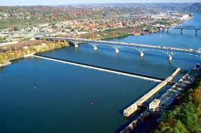
During the 19th century, the river became a principal means of navigation in the upper Ohio valley, especially for the transport of coal. Although the building of the railroads lessened the importance of the river somewhat, the lower river (navigable as far as East Brady, Pennsylvania through locks) has continued to serve as route of commercial transportation until the present day. In 1859, the first U.S. petroleum was drilled north of the river at Titusville.
In 1965, the completion of the federally-sponsored Kinzua Dam for flood-control in northwestern Pennsylvania east of Warren created the long Allegheny Reservoir, part of which is included in the Allegheny National Recreation Area. The dam flooded parts of lands deeded "forever" to the Seneca tribe and to Cornplanter and his descendants. (The event is described in the Johnny Cash tune "As Long as the Grass Shall Grow.")
In 1992, 86.6 miles (139 km) of the Allegheny was designated Wild and Scenic. This designation comprises three segments of the river located in Warren, Forest and Venango Counties.[2]
Cities and towns along the Allegheny River
New York
- Allegany
- Carrollton
- Olean
- Portville
- St. Bonaventure
- Salamanca
- Weston Mills
Pennsylvania
- Applewold
- Arnold
- Aspinwall
- Blawnox
- Brackenridge
- Cadogan
- Cheswick
- Coudersport
- East Brady
- Eldred
- Emlenton
- Etna
- Ford City
- Foxburg
- Franklin
- Freeport
- Kittanning
- Lower Burrell
- Manorville
- Millvale
- New Kensington
- Oakmont
- Oil City
- O'Hara Township
- Parker
- Penn Hills
- Pittsburgh
- Plum
- Port Allegany
- Schenley
- Sharpsburg
- Springdale
- Tarentum
- Templeton
- Tidioute
- Tionesta
- Verona
- Warren
- West Kittanning
- Youngsville
See also
- List of crossings of the Allegheny River
- List of New York rivers
- List of Pennsylvania rivers
- List of National Wild and Scenic Rivers
- Allegheny Islands Wilderness
Notes
- ↑ Stewart, George R. (1967, pg. 8) Names on the Land. Boston: Houghton Mifflin Company.
- ↑ Allegheny Wild and Scenic River - Allegheny National Forest
ReferencesISBN links support NWE through referral fees
External links
All links Retrieved July 18, 2008.
Online maps and aerial photos
Mouth or other endpoint (Pittsburgh)
- WikiSatellite view at WikiMapia
- Street map from MapQuest
- Topographic map from TopoZone
- Satellite image from Google Maps
Credits
New World Encyclopedia writers and editors rewrote and completed the Wikipedia article in accordance with New World Encyclopedia standards. This article abides by terms of the Creative Commons CC-by-sa 3.0 License (CC-by-sa), which may be used and disseminated with proper attribution. Credit is due under the terms of this license that can reference both the New World Encyclopedia contributors and the selfless volunteer contributors of the Wikimedia Foundation. To cite this article click here for a list of acceptable citing formats.The history of earlier contributions by wikipedians is accessible to researchers here:
The history of this article since it was imported to New World Encyclopedia:
Note: Some restrictions may apply to use of individual images which are separately licensed.

