Difference between revisions of "Scandinavian Peninsula" - New World Encyclopedia
(spell check) |
(addd category) |
||
| Line 1: | Line 1: | ||
| + | {{images OK}} | ||
| + | {{ready}} | ||
{{Wrapper}} | {{Wrapper}} | ||
| {{Scandinavia}} | | {{Scandinavia}} | ||
|} | |} | ||
| − | The '''Scandinavian Peninsula''' is a geographic region in northern [[Europe]], consisting principally of the [[mainland]] territories of [[Norway]] and [[Sweden]]. The name ''[[Scandinavia]]n'' is [[etymology|derived from]] ''[[Scania]]'',<ref>Haugen, Einar (1976). ''The Scandinavian Languages: An Introduction to Their History''. Cambridge, Mass: Harvard University Press, 1976 | + | The '''Scandinavian Peninsula''' is a geographic region in northern [[Europe]], consisting principally of the [[mainland]] territories of [[Norway]] and [[Sweden]]. The name ''[[Scandinavia]]n'' is [[etymology|derived from]] ''[[Scania]]'',<ref>Haugen, Einar (1976). ''The Scandinavian Languages: An Introduction to Their History''. Cambridge, Mass: Harvard University Press, 1976. ISBN 0674790022</ref> a region at the southernmost extremity of the peninsula. A small section of northwestern [[Finland]] is also on the peninsula and on its [[isthmus]]. |
The peninsula is part of a larger geographical feature, [[Fennoscandia]], and extends from [[Russia]] and Finland in the northeast toward [[Denmark]] and [[Germany]] to the south and southwest. | The peninsula is part of a larger geographical feature, [[Fennoscandia]], and extends from [[Russia]] and Finland in the northeast toward [[Denmark]] and [[Germany]] to the south and southwest. | ||
| Line 11: | Line 13: | ||
The [[Scandinavian mountain range]] generally defines the borders between the three countries, although it also continues into the central parts of southern Norway. The peninsula is bordered by several bodies of water including: | The [[Scandinavian mountain range]] generally defines the borders between the three countries, although it also continues into the central parts of southern Norway. The peninsula is bordered by several bodies of water including: | ||
| − | *the [[Baltic Sea]] (including the [[Gulf of Bothnia]]) to the east, with the autonomous [[Åland|Åland islands]] between Sweden | + | *the [[Baltic Sea]] (including the [[Gulf of Bothnia]]) to the east, with the autonomous [[Åland|Åland islands]] between Sweden and Finland, and [[Gotland]]. |
*the [[North Sea]] (including the [[Kattegat]] and [[Skagerrak]]) to the west and southwest | *the [[North Sea]] (including the [[Kattegat]] and [[Skagerrak]]) to the west and southwest | ||
*the [[Norwegian Sea]] to the west | *the [[Norwegian Sea]] to the west | ||
| Line 17: | Line 19: | ||
Its highest elevation was [[Glittertinden]] in Norway at 2,470 m (8,104 ft) above sea level, but since the glacier at its summit partially melted {{Fact|date=February 2007}}, the highest elevation is at 2,469 m (8,101 ft) at [[Galdhøpiggen]], also in Norway. These mountains also house the largest [[glacier]] on mainland Europe, [[Jostedalsbreen]]. | Its highest elevation was [[Glittertinden]] in Norway at 2,470 m (8,104 ft) above sea level, but since the glacier at its summit partially melted {{Fact|date=February 2007}}, the highest elevation is at 2,469 m (8,101 ft) at [[Galdhøpiggen]], also in Norway. These mountains also house the largest [[glacier]] on mainland Europe, [[Jostedalsbreen]]. | ||
About one quarter of the peninsula lies north of the Arctic Circle, with the northernmost point at Cape [[Nordkyn]]. | About one quarter of the peninsula lies north of the Arctic Circle, with the northernmost point at Cape [[Nordkyn]]. | ||
| − | The climate across the peninsula varies from tundra ([[Köppen climate classification|Köppen]]: ET) and subarctic (Dfc) in the north, with cool marine west coast climate (Cfc) in northwestern coastal areas reaching just north of [[Lofoten]], to humid continental (Dfb) in the central portion, and to marine west coast (Cfb) in the south and southwest.<ref name="arclimate">[http://www.utexas.edu/depts/grg/kimmel/GRG301K/grg301kkoppen.html Glossary of American climate terminology in terms of Köppens classification]</ref> | + | The climate across the peninsula varies from tundra ([[Köppen climate classification|Köppen]]: ET) and subarctic (Dfc) in the north, with cool marine west coast climate (Cfc) in northwestern coastal areas reaching just north of [[Lofoten]], to humid continental (Dfb) in the central portion, and to marine west coast (Cfb) in the south and southwest.<ref name="arclimate">[http://www.utexas.edu/depts/grg/kimmel/GRG301K/grg301kkoppen.html Glossary of American climate terminology in terms of Köppens classification], University of Texas. Retrieved December 21, 2007.</ref> |
The region is rich in timber, iron and copper with the best farmland in southern Sweden. Large petroleum and natural-gas deposits have been found off Norway's coast in the North Sea and the Atlantic Ocean. | The region is rich in timber, iron and copper with the best farmland in southern Sweden. Large petroleum and natural-gas deposits have been found off Norway's coast in the North Sea and the Atlantic Ocean. | ||
| − | Much of the population is concentrated in the southern part of the peninsula; [[Stockholm]] and [[Gothenburg]], both in Sweden, and [[Oslo]] in Norway are the largest cities.<ref name="factmonster">{{cite web|title=Scandinavia|work=FactMonster.com|url=http://www.factmonster.com/ce6/world/A0843871.html|accessdate= | + | Much of the population is concentrated in the southern part of the peninsula; [[Stockholm]] and [[Gothenburg]], both in Sweden, and [[Oslo]] in Norway are the largest cities.<ref name="factmonster">{{cite web|title=Scandinavia|work=FactMonster.com|url=http://www.factmonster.com/ce6/world/A0843871.html|accessdate=December 21, 2007}}</ref> |
==Geology== | ==Geology== | ||
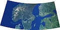
[[Image:Scandinavia.jpg|thumb|200px|right|Scandinavian Peninsula]] | [[Image:Scandinavia.jpg|thumb|200px|right|Scandinavian Peninsula]] | ||
| − | The Scandinavian Peninsula occupies part of the [[Baltic Shield]], a stable and large crust segment formed of very old, crystalline [[metamorphic rock]]s. Most of the soil covering this substrate was scraped by glaciers during continental [[glaciation]], especially in the northern part, where the shield is nearest the surface. As a consequence of this scouring, the elevation and the climate, a very small percentage of land is [[Arable land|arable]] (3% in Norway).<ref name="Hobbs">Hobbs, Joseph J. and Salter, Christopher L.''Essentials Of World Regional Geography'', | + | The Scandinavian Peninsula occupies part of the [[Baltic Shield]], a stable and large crust segment formed of very old, crystalline [[metamorphic rock]]s. Most of the soil covering this substrate was scraped by glaciers during continental [[glaciation]], especially in the northern part, where the shield is nearest the surface. As a consequence of this scouring, the elevation and the climate, a very small percentage of land is [[Arable land|arable]] (3% in Norway).<ref name="Hobbs">Hobbs, Joseph J. and Salter, Christopher L.''Essentials Of World Regional Geography'', Thomson Brooks/Cole, 2005. p. 108. ISBN 0534466001</ref> The glaciers also deepened river valleys, which were invaded by the sea when the ice melted, creating the famous [[fjords]]. In the south the glaciers deposited many sedimental deposits, configuring a very chaotic landscape.<ref name="Ostergren">Ostergren, Robert C., Rice, John G. ''The Europeans''. Guilford Press. 2004. ISBN 0898622727</ref> |
Although the Baltic Shield is largely stable and resistant to the influences of other neighboring tectonic formations, the weight of nearly four kilometers of ice sheet caused the terrain to sink down. When the ice sheet disappeared, the shield rose again, a tendency that continues to this day at a rate of about 1 meter per century.<ref name="Ostergren"/> Conversely, the south part has tended to sink down to compensate, causing the flooding of the [[Low Countries]] and [[Denmark]]. | Although the Baltic Shield is largely stable and resistant to the influences of other neighboring tectonic formations, the weight of nearly four kilometers of ice sheet caused the terrain to sink down. When the ice sheet disappeared, the shield rose again, a tendency that continues to this day at a rate of about 1 meter per century.<ref name="Ostergren"/> Conversely, the south part has tended to sink down to compensate, causing the flooding of the [[Low Countries]] and [[Denmark]]. | ||
| Line 31: | Line 33: | ||
==People== | ==People== | ||
| − | The first recorded human presence in the southern area of the peninsula and Denmark dates from 12,000 years ago.<ref name="Tilley">Tilley, Christopher Y. ''Ethnography of the Neolithic: Early Prehistoric Societies in Southern Scandinavia'', p. 9, Cambridge University Press. 2003. ISBN | + | The first recorded human presence in the southern area of the peninsula and Denmark dates from 12,000 years ago.<ref name="Tilley">Tilley, Christopher Y. ''Ethnography of the Neolithic: Early Prehistoric Societies in Southern Scandinavia'', p. 9, Cambridge University Press. 2003. ISBN 0521568218</ref> As the ice sheets from the glaciation retreated, the climate allowed a [[tundra]] [[biome]] that attracted [[reindeer]] hunters. The climate warmed gradually up, favoring the growth of perennial trees first, and then [[deciduous]] forest which brought animals like [[aurochs]]. Groups of hunters-fishers-gatherers started to inhabit the area since the [[Mesolithic]] (8200 B.C.E.), up to the advent of agriculture in the [[Neolithic]] (3200 B.C.E.). |
The northern and central part of the peninsula is partially inhabited by the [[Sami people|Sami]], often referred to as "Lapps" or "Laplanders." In the earliest recorded periods they occupied the [[arctic]] and [[subarctic]] regions as well as the central part of the peninsula as far south as [[Dalarna]], Sweden. They speak the [[Sami languages|Sami language]], a non-[[Indo-European language]] of the [[Finno-Ugric languages|Finno-Ugric]] family, which is related to [[Finnish language|Finnish]] and [[Estonian language|Estonian]]. The other inhabitants of the peninsula, according to [[ninth century]] records, were the Norwegians on the west coast of Norway, the [[Denmark|Danes]] in what is now southern and western Sweden and southeastern Norway, the [[Svear]] in the region around [[Mälaren]] as well as a large portion of the present day eastern seacoast of Sweden and the [[Geat]]s in [[Västergötland]] and [[Östergötland]]. These peoples spoke closely related [[dialect]]s of an Indo-European language, [[Old Norse]]. Although political boundaries have shifted, these peoples still are the dominant populations in the peninsula in the early [[21st century]].<ref name=" Sawyer">{{cite book|author=Sawyer, Bridget and Peter|title=Medieval Scandinavia: from conversion to Reformation, circa 800-1500 |University of Minnesota Press|year=1993|id=ISBN 0816617384 }}</ref> | The northern and central part of the peninsula is partially inhabited by the [[Sami people|Sami]], often referred to as "Lapps" or "Laplanders." In the earliest recorded periods they occupied the [[arctic]] and [[subarctic]] regions as well as the central part of the peninsula as far south as [[Dalarna]], Sweden. They speak the [[Sami languages|Sami language]], a non-[[Indo-European language]] of the [[Finno-Ugric languages|Finno-Ugric]] family, which is related to [[Finnish language|Finnish]] and [[Estonian language|Estonian]]. The other inhabitants of the peninsula, according to [[ninth century]] records, were the Norwegians on the west coast of Norway, the [[Denmark|Danes]] in what is now southern and western Sweden and southeastern Norway, the [[Svear]] in the region around [[Mälaren]] as well as a large portion of the present day eastern seacoast of Sweden and the [[Geat]]s in [[Västergötland]] and [[Östergötland]]. These peoples spoke closely related [[dialect]]s of an Indo-European language, [[Old Norse]]. Although political boundaries have shifted, these peoples still are the dominant populations in the peninsula in the early [[21st century]].<ref name=" Sawyer">{{cite book|author=Sawyer, Bridget and Peter|title=Medieval Scandinavia: from conversion to Reformation, circa 800-1500 |University of Minnesota Press|year=1993|id=ISBN 0816617384 }}</ref> | ||
| Line 37: | Line 39: | ||
==Political development== | ==Political development== | ||
[[Image:Schweden_und_Norwegen_um_1888.jpg|thumb|200px|left|The Scandinavian Peninsula political borders in 1888.]] | [[Image:Schweden_und_Norwegen_um_1888.jpg|thumb|200px|left|The Scandinavian Peninsula political borders in 1888.]] | ||
| − | Although the [[Nordic countries]] (except for Iceland, Finland and Norway which gained full independence in the 20th century and Sweden which took part in the Kalmar Union under Denmark) look back on more than 1000 years of history as distinct political entities, the international boundaries came late and emerged gradually. It was not until the middle of the middle of [[17th century]] that Sweden secured an outlet on the [[Kattegat]] and control of the south Baltic coast. The Swedish and Norwegian boundaries were finally agreed to and marked out in 1751. The Finnish and Norwegian border on the peninsula was established after extensive negotiation in 1809, and the common Norwegian-Russian districts were not partitioned until 1826. Even then the borders were still fluid, with Finland gaining access to the [[Barents Sea]] in 1920, but ceding this territory to Russia in 1944.<ref name="Sømme">{{cite book|author=Sømme, Axel (Ed.) |title=The Geography of Norden|location=Oslo | publisher=Den Norske nasjonalkommittee for geographi|year=1961|id= | + | Although the [[Nordic countries]] (except for Iceland, Finland and Norway which gained full independence in the 20th century and Sweden which took part in the Kalmar Union under Denmark) look back on more than 1000 years of history as distinct political entities, the international boundaries came late and emerged gradually. It was not until the middle of the middle of [[17th century]] that Sweden secured an outlet on the [[Kattegat]] and control of the south Baltic coast. The Swedish and Norwegian boundaries were finally agreed to and marked out in 1751. The Finnish and Norwegian border on the peninsula was established after extensive negotiation in 1809, and the common Norwegian-Russian districts were not partitioned until 1826. Even then the borders were still fluid, with Finland gaining access to the [[Barents Sea]] in 1920, but ceding this territory to Russia in 1944.<ref name="Sømme">{{cite book|author=Sømme, Axel (Ed.) |title=The Geography of Norden|location=Oslo | publisher=Den Norske nasjonalkommittee for geographi|year=1961|id=}} {{OCLC|164877494}}</ref> |
==See also== | ==See also== | ||
| Line 55: | Line 57: | ||
[[Category:Geography]] | [[Category:Geography]] | ||
| + | [[Category:Peninsulas]] | ||
{{credits|170297865}} | {{credits|170297865}} | ||
Revision as of 14:19, 21 December 2007
|
The Scandinavian Peninsula is a geographic region in northern Europe, consisting principally of the mainland territories of Norway and Sweden. The name Scandinavian is derived from Scania,[1] a region at the southernmost extremity of the peninsula. A small section of northwestern Finland is also on the peninsula and on its isthmus.
The peninsula is part of a larger geographical feature, Fennoscandia, and extends from Russia and Finland in the northeast toward Denmark and Germany to the south and southwest.
Geography

The Scandinavian Peninsula is approximately 1,850 kilometers (1,150 miles) long and between approximately 370–805 km (230-500 mi) wide. It has an overall area of approximately 777,000 km² (300,000 sq mi).
The Scandinavian mountain range generally defines the borders between the three countries, although it also continues into the central parts of southern Norway. The peninsula is bordered by several bodies of water including:
- the Baltic Sea (including the Gulf of Bothnia) to the east, with the autonomous Åland islands between Sweden and Finland, and Gotland.
- the North Sea (including the Kattegat and Skagerrak) to the west and southwest
- the Norwegian Sea to the west
- the Barents Sea to the north
Its highest elevation was Glittertinden in Norway at 2,470 m (8,104 ft) above sea level, but since the glacier at its summit partially melted [citation needed], the highest elevation is at 2,469 m (8,101 ft) at Galdhøpiggen, also in Norway. These mountains also house the largest glacier on mainland Europe, Jostedalsbreen. About one quarter of the peninsula lies north of the Arctic Circle, with the northernmost point at Cape Nordkyn. The climate across the peninsula varies from tundra (Köppen: ET) and subarctic (Dfc) in the north, with cool marine west coast climate (Cfc) in northwestern coastal areas reaching just north of Lofoten, to humid continental (Dfb) in the central portion, and to marine west coast (Cfb) in the south and southwest.[2] The region is rich in timber, iron and copper with the best farmland in southern Sweden. Large petroleum and natural-gas deposits have been found off Norway's coast in the North Sea and the Atlantic Ocean.
Much of the population is concentrated in the southern part of the peninsula; Stockholm and Gothenburg, both in Sweden, and Oslo in Norway are the largest cities.[3]
Geology

The Scandinavian Peninsula occupies part of the Baltic Shield, a stable and large crust segment formed of very old, crystalline metamorphic rocks. Most of the soil covering this substrate was scraped by glaciers during continental glaciation, especially in the northern part, where the shield is nearest the surface. As a consequence of this scouring, the elevation and the climate, a very small percentage of land is arable (3% in Norway).[4] The glaciers also deepened river valleys, which were invaded by the sea when the ice melted, creating the famous fjords. In the south the glaciers deposited many sedimental deposits, configuring a very chaotic landscape.[5]
Although the Baltic Shield is largely stable and resistant to the influences of other neighboring tectonic formations, the weight of nearly four kilometers of ice sheet caused the terrain to sink down. When the ice sheet disappeared, the shield rose again, a tendency that continues to this day at a rate of about 1 meter per century.[5] Conversely, the south part has tended to sink down to compensate, causing the flooding of the Low Countries and Denmark.
The crystalline substrate and absence of soil exposes mineral deposits of metals, like iron, copper, nickel, zinc, silver and gold.
People
The first recorded human presence in the southern area of the peninsula and Denmark dates from 12,000 years ago.[6] As the ice sheets from the glaciation retreated, the climate allowed a tundra biome that attracted reindeer hunters. The climate warmed gradually up, favoring the growth of perennial trees first, and then deciduous forest which brought animals like aurochs. Groups of hunters-fishers-gatherers started to inhabit the area since the Mesolithic (8200 B.C.E.), up to the advent of agriculture in the Neolithic (3200 B.C.E.).
The northern and central part of the peninsula is partially inhabited by the Sami, often referred to as "Lapps" or "Laplanders." In the earliest recorded periods they occupied the arctic and subarctic regions as well as the central part of the peninsula as far south as Dalarna, Sweden. They speak the Sami language, a non-Indo-European language of the Finno-Ugric family, which is related to Finnish and Estonian. The other inhabitants of the peninsula, according to ninth century records, were the Norwegians on the west coast of Norway, the Danes in what is now southern and western Sweden and southeastern Norway, the Svear in the region around Mälaren as well as a large portion of the present day eastern seacoast of Sweden and the Geats in Västergötland and Östergötland. These peoples spoke closely related dialects of an Indo-European language, Old Norse. Although political boundaries have shifted, these peoples still are the dominant populations in the peninsula in the early 21st century.[7]
Political development

Although the Nordic countries (except for Iceland, Finland and Norway which gained full independence in the 20th century and Sweden which took part in the Kalmar Union under Denmark) look back on more than 1000 years of history as distinct political entities, the international boundaries came late and emerged gradually. It was not until the middle of the middle of 17th century that Sweden secured an outlet on the Kattegat and control of the south Baltic coast. The Swedish and Norwegian boundaries were finally agreed to and marked out in 1751. The Finnish and Norwegian border on the peninsula was established after extensive negotiation in 1809, and the common Norwegian-Russian districts were not partitioned until 1826. Even then the borders were still fluid, with Finland gaining access to the Barents Sea in 1920, but ceding this territory to Russia in 1944.[8]
See also
- History of Scandinavia
- Nordic countries
- Scandinavia
Scandinavia and the Baltic region
- Scandinavian Peninsula in Winter (February 19, 2003).jpg
Scandinavian Peninsula in winter (February 19, 2003)

Notes
- ↑ Haugen, Einar (1976). The Scandinavian Languages: An Introduction to Their History. Cambridge, Mass: Harvard University Press, 1976. ISBN 0674790022
- ↑ Glossary of American climate terminology in terms of Köppens classification, University of Texas. Retrieved December 21, 2007.
- ↑ Scandinavia. FactMonster.com. Retrieved December 21, 2007.
- ↑ Hobbs, Joseph J. and Salter, Christopher L.Essentials Of World Regional Geography, Thomson Brooks/Cole, 2005. p. 108. ISBN 0534466001
- ↑ 5.0 5.1 Ostergren, Robert C., Rice, John G. The Europeans. Guilford Press. 2004. ISBN 0898622727
- ↑ Tilley, Christopher Y. Ethnography of the Neolithic: Early Prehistoric Societies in Southern Scandinavia, p. 9, Cambridge University Press. 2003. ISBN 0521568218
- ↑ Sawyer, Bridget and Peter (1993). Medieval Scandinavia: from conversion to Reformation, circa 800-1500. ISBN 0816617384.
- ↑ Sømme, Axel (Ed.) (1961). The Geography of Norden. Oslo: Den Norske nasjonalkommittee for geographi. OCLC 164877494
Credits
New World Encyclopedia writers and editors rewrote and completed the Wikipedia article in accordance with New World Encyclopedia standards. This article abides by terms of the Creative Commons CC-by-sa 3.0 License (CC-by-sa), which may be used and disseminated with proper attribution. Credit is due under the terms of this license that can reference both the New World Encyclopedia contributors and the selfless volunteer contributors of the Wikimedia Foundation. To cite this article click here for a list of acceptable citing formats.The history of earlier contributions by wikipedians is accessible to researchers here:
The history of this article since it was imported to New World Encyclopedia:
Note: Some restrictions may apply to use of individual images which are separately licensed.