Tikal National Park
Mary Anglin (talk | contribs) m (→Site detail) |
Mary Anglin (talk | contribs) |
||
| Line 23: | Line 23: | ||
== History == | == History == | ||
| − | Tikal was a dominating influence in the southern Maya lowlands throughout most of the Early Classic. The site, however, was often at war and inscriptions tell of alliances and conflict with other Maya states, including [[Uaxactun]], [[Caracol, Belize|Caracol]], [[Dos Pilas]], [[Naranjo]], and [[Calakmul]]. The site was defeated at the end of the Early Classic by Caracol, who rose to take Tikal's place as the paramount center in the southern Maya lowlands. It appears another defeat was suffered at the hands of Dos Pilas during the middle [[7th century]], with the possible capture and sacrifice of Tikal's ruler at the time (Sharer 1994:265). | + | Tikal was a dominating influence in the southern Maya lowlands throughout most of the Early Classic Period. The site, however, was often at war and inscriptions tell of alliances and conflict with other Maya states, including [[Uaxactun]], [[Caracol, Belize|Caracol]], [[Dos Pilas]], [[Naranjo]], and [[Calakmul]]. The site was defeated at the end of the Early Classic by Caracol, who rose to take Tikal's place as the paramount center in the southern Maya lowlands. It appears another defeat was suffered at the hands of Dos Pilas during the middle [[7th century]], with the possible capture and sacrifice of Tikal's ruler at the time (Sharer 1994:265). |
===Tikal hiatus=== | ===Tikal hiatus=== | ||
Revision as of 23:49, 13 June 2008
| Tikal National Park* | |
|---|---|
| UNESCO World Heritage Site | |

| |
| State Party | |
| Type | Mixed |
| Criteria | i, iii, iv, ix, x |
| Reference | 64 |
| Region** | Latin America and the Caribbean |
| Inscription history | |
| Inscription | 1979 (3rd Session) |
| * Name as inscribed on World Heritage List. ** Region as classified by UNESCO. | |
Tikal (or Tik’al, according to the more current orthography) is the largest of the ancient ruined cities of the Maya civilization. It is located in the El Petén department of Guatemala. Now part of Guatemala's Tikal National Park, it is a UNESCO World Heritage Site and a popular tourist spot. The closest large towns are Flores and Santa Elena, about 18.5 miles (30 km) away.
Tikal was one of the major cultural and population centers of the Maya civilization. Though monumental architecture at the site dates to the 4th century B.C.E., Tikal reached its apogee during the Classic Period, ca. 200 C.E. to 900 C.E., during which time the site dominated the Maya region politically, economically, and militarily while interacting with areas throughout Mesoamerica, such as central Mexican center of Teotihuacan. Following the end of the Late Classic Period, no new major monuments were built at Tikal and there is some evidence that elite palaces were burned. These events were coupled with a gradual population decline, culminating with the site’s abandonment by the end of the 10th century.
Etymology

The name Tikal, 'place of the voices' in Itza Maya, is not the ancient name for the site but rather the name adopted shortly after its discovery in the 1840s. Hieroglyphic inscriptions at the ruins refer to the central area of the ancient city as Yax Mutal or Yax Mutul. The kingdom as a whole was simply called Mutal or Mutul, which is the reading of the "hair bundle" Emblem Glyph seen in the accompanying photo. Its meaning remains obscure, although some scholars think that it is the Hair knot of the Ahau or ruler.
History
Tikal was a dominating influence in the southern Maya lowlands throughout most of the Early Classic Period. The site, however, was often at war and inscriptions tell of alliances and conflict with other Maya states, including Uaxactun, Caracol, Dos Pilas, Naranjo, and Calakmul. The site was defeated at the end of the Early Classic by Caracol, who rose to take Tikal's place as the paramount center in the southern Maya lowlands. It appears another defeat was suffered at the hands of Dos Pilas during the middle 7th century, with the possible capture and sacrifice of Tikal's ruler at the time (Sharer 1994:265).
Tikal hiatus
The "Tikal hiatus" refers to a period between the late 6th to late 7th century where there was a lapse in the writing of inscriptions and large-scale construction at Tikal. This hiatus in activity at Tikal was long unexplained until later epigraphic decipherments identified that the period was prompted by Tikal's comprehensive defeat at the hands of the Caracol polity in A.D. 562 after six years of warfare against an alliance of Calakmul, Dos Pilas and Naranjo. The hiatus at Tikal lasted up to the ascension of Jasaw Chan K'awiil I (Ruler A) in A.D. 682. In A.D. 695, Yukno’m Yich’Aak K’ahk’ of Calakmul (Kanal), was defeated by the new ruler of Tikal, Jasaw Chan K'awiil I, Nu’n U Jol Chaak’s heir. This defeat of Calakmul restores Tikal’s preeminence in the Central Maya region, but never again in the southwest Petén, where Dos Pilas maintained its presence.
The beginning of the Tikal hiatus has served as a marker by which archaeologists commonly sub-divide the Classic period of Mesoamerican chronology into the Early and Late Classic.[1]
Rulers
The known rulers of Tikal, with general or specific dates attributed to them, include the following:

King of Tikal from wooden lintel in Temple III Depicting either "Yax Nuun Ayin II" or "Dark Sun"
Late Preclassic
- Yax Ehb' Xook – ca. A.D. 60, dynastic founder
- Siyaj Chan K'awil Chak Ich'aak ("Stormy Sky I") – ca. 2nd century
- Yax Ch’aktel Xok – ca. 200
Early Classic
- Balam Ajaw ("Decorated Jaguar") – A.D. 292
- K'inich Ehb' – ca. A.D. 300
- Ix Une' B'alam ("Queen Jaguar") – A.D. 317
- "Leyden Plate Ruler" – A.D. 320
- K'inich Muwaan Jol – died A.D. 359
- Chak Tok Ich'aak I ("Jaguar Paw I") – c.a. 360-378. His palace, unusually, was never built over by later rulers, and was kept in repair for centuries as an apparent revered monument. He died on the same day that Siyah K'ak' arrived in Tikal, probably executed by the Teotihuacano conquerors.
- Nun Yax Ayin – A.D. 370-411. Nun Yax Ayin was a noble from Teotihuacan who was installed on Tikal's throne in 379 by Siyaj K'ak'.
- Siyaj Chan K'awiil II ("Stormy Sky II") – A.D. 411-456.
- K'an-Ak ("Kan Boar") – A.D. 458-486.
- Ma'Kin-na Chan – ca. late 5th century.
- Chak Tok Ich'aak (Bahlum Paw Skull) – A.D. 486-508. Married to "Lady Hand"
- Ix Kalo'mte' Ix Yo K'in ("Lady of Tikal") – A.D. 511-527. Co-ruled with Kaloomte' B'alam, possibly as consort.
- Kaloomte' B'alam ("Curl-Head" and "19th Lord") – A.D. 511-527. Co-ruled with Ix Kalo'mte' Ix Yo K'in ("Lady of Tikal"), as regent.
- "Bird Claw" ("Animal Skull I," "Ete I") – ca. A.D. 527–537.
- Wak Chan K'awiil ("Double-Bird") – A.D. 537-562. Capture and possible sacrifice by Caracol.
- "Lizard Head II" – Unknown, lost a battle with Caracol in A.D. 562.
Hiatus
- K'inich Waaw – A.D. 593-628.
- K'inich Wayaan – ca. early/mid 7th century.
- K'inich Muwaan Jol II – ca. early/mid 7th century.
Late Classic
- Jasaw Chan K'awiil I (a.k.a. Ruler A or Ah Cacao) – A.D. 682-734. Entombed in Temple I. His queen Lady Twelve Macaw (died A.D. 704) is entombed in Temple II. Triumphed in war with Calakmul in A.D. 711.
- Yik'in Chan K'awiil (a.k.a. Ruler B) – A.D. 734-766. His wife was Shana'Kin Yaxchel Pacal "Green Jay on the Wall" of Lakamha. It is unknown exactly where is tomb lies, but strong archaeological parallels between Burial 116 (the resting place of his father) and Burial 196, located in the diminutive pyramid immediately south of Temple II and referred to as Str. 5D-73, suggest the latter may be the tomb of Yik’in Chan Kawil (Sharer 1994:169). Other possible locations, and likely candidates as mortuary shrines, include Temples IV and VI.
- "Temple VI Ruler" – A.D. 766-768
- Yax Nuun Ayiin II ("Chitam") – A.D. 768-790
- Chitam II ("Dark Sun") – Buried ca. A.D. 810 Buried in Temple III
- "Jewel K'awil" – A.D. 849
- Jasaw Chan K'awiil II – A.D. 869-889
Note: English language names are provisional nicknames based on their identifying glyphs, where rulers' Maya language names have not yet been definitively deciphered phonetically.
Modern history

As is often the case with huge ancient ruins, knowledge of the site was never completely lost in the region. Some second- or third-hand accounts of Tikal appeared in print starting in the 17th century, continuing through the writings of John Lloyd Stephens in the early 19th century (Stephens and his illustrator Frederick Catherwood heard rumors of a lost city, with white building tops towering above the jungle, during their 1839-40 travels in the region). Due to the site's remoteness from modern towns, however, no explorers visited Tikal until Modesto Méndez and Ambrosio Tut visited it in 1848. Several other expeditions came to further investigate, map, and photograph Tikal in the 19th century (including Alfred P. Maudslay in 1881-82) and the early 20th century.
In 1951 a small airstrip was built at the ruins, which previously could only be reached by several days travel through the jungle on foot or mule. From 1956 through 1970 major archaeological excavations were made by the University of Pennsylvania. In 1979 the Guatemalan government began a further archaeological project at Tikal, which continues to this day.
Site characteristics

Environmental setting
The ruins of Tikal lie on lowland rainforest. Conspicuous trees at the Tikal National Park include gigantic ceiba (Ceiba pentandra) the sacred tree of the Maya; tropical cedar (Cedrela odorata), and mahogany (Swietenia).
Animal life commonly seen includes agouti, coatis, gray foxes, spider monkeys, howler monkeys, Harpy Eagles, Falcons, ocellated turkeys, guans, toucans, green parrots and leaf-cutting ants. Jaguars, Jaguarundis and Cougars are also said to roam in the park.
The largest of the Classic Maya cities, Tikal had no water source other than what was collected from rainwater and stored in underground storage facilities. Archaeologists working in Tikal during the last century utilized the ancient underground facilities to store water for their own use. The absence of springs, rivers, and lakes in the immediate vicinity of Tikal highlights a prodigious feat: building a major city with only supplies of stored seasonal rainfall. Tikal prospered with intensive agricultural techniques, which were far more advanced than the slash & burn methods originally theorized by archaeologists. The reliance on seasonal rainfall left Tikal vulnerable to prolonged drought, which is now thought to have played a major role in the Classic Maya Collapse.
Site detail


There are thousands of ancient structures at Tikal, with only a fraction of them having been excavated after decades of archaeological work. The most prominent surviving buildings include six very large Mesoamerican step pyramids, labeled Temples I - VI, each of which support a temple structure on their summits. Some of these pyramids are over 200 feet (60 meters high). They were numbered sequentially during the early survey of the site.
The majority of pyramids currently visible at Tikal were built during Tikal’s resurgence following the Tikal Hiatus (between the late 7th and the early 9th centuries). It should be noted, however, that the majority of these structures contain sub-structures that were initially built prior to the hiatus period.
Temple I (also known as the Temple of Ah Cacao or Temple of the Great Jaguar) was built around C.E. 695; Temple II or the Moon Temple in C.E. 702; and Temple III in C.E. 810. The largest structure at Tikal, Temple IV, is approximately 230 feet (70 meters) tall. Temple IV marks the reign of Yik’in Chan Kawil (Ruler B, the son of Ruler A or Jasaw Chan K'awiil I) and two carved wooden lintels over the doorway that leads into the temple on the pyramid’s summit record a long count date (9.15.10.0.0) that corresponds to C.E. 741 (Sharer 1994:169). Temple V dates to about C.E. 750, and is the only temple where no tomb has been found. Temple VI, also known as the Temple of the Inscriptions, was dedicated in C.E. 766.
The Lost World Pyramid (Str. 5C-54) is in the southwest portion of Tikal’s central core and west of Temple V. A 30 meter high "True Pyramid," with stairways in 3 sides and stucco masks, dating to the Late Preclassic, this pyramid is part of an enclosed complex of structures that remained intact through, and un-impacted by, later building activity at Tikal.
The ancient city also has the remains of royal palaces, in addition to a number of smaller pyramids, palaces, residences, and inscribed stone monuments. There is even a building which seemed to have been a jail, originally with wooden bars across the windows and doors. There are also seven courts for playing the Mesoamerican ballgame, including a set of 3 in the "Seven Temples Plaza" a unique feature in Mesoamerica.
The residential area of Tikal covers an estimated 23 square miles (60 sq km), much of which has not yet been cleared, mapped, or excavated. A huge set of earthworks has been discovered ringing Tikal with a 6 meter wide trench behind a rampart. Only some 9 km of it has been mapped; it may have enclosed an area of some 125 square kilometers. Population estimates place the demographic size of the site between 100,000 and 200,000.
Recently, a project exploring the earthworks has shown that the scale of the earthworks is highly variable and that in many places it is inconsequential as a defensive feature. In addition, some parts of the earthwork were integrated into a canal system. The earthwork of Tikal varies significantly in coverage from what was originally proposed and it is much more complex and multifaceted than originally thought.


Photo gallery
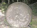
Engraved altar 5.
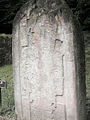
Engraved stelae.
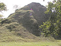
True pyramid at Mundo Perdido.
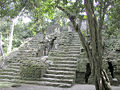
Pyramid steps.
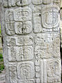
Stone engravings.
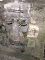
Large stone mask at the North Acropolis complex, representing the Principal Bird Deity.[2]
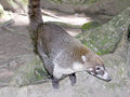
Coati at Tikal.

Photo-textured Laser scan elevation of Tikal's Temple II, showing measurements and dimensions for this Step pyramid.


Notes
- ↑ Miller and Taube (1993), p.20.
- ↑ See annotations of the equivalent images of this mask, Nos. 7909A, 7909B, 7909C, at the Justin Kerr Precolumbian Portfolio (Kerr n.d.)
ReferencesISBN links support NWE through referral fees
- Coe, Michael D. 1987. The Maya. New York, N.Y.: Thames and Hudson. ISBN 050027455X and ISBN 9780500274552
- Drew, David. 1999. The lost chronicles of the Maya kings. Berkeley: University of California Press. ISBN 0520226127 and ISBN 9780520226
- Eggebrecht, Eva, Nikolai Grube, and Matthias Seidel. 2006. Maya: divine kings of the rain forest. Cologne: Konemann. ISBN 3833119578 and ISBN 9783833119576
- Gill, Richardson Benedict. 2000. The great Maya droughts: water, life, and death. Albuquerque: University of New Mexico Press. ISBN 0826321941 and ISBN 9780826321947
- Kerr, Justin. A Precolumbian Portfolio. Foundation for the Advancement of Mesoamerican Studies, Inc. Retrieved May 17, 2008
- Miller, Mary Ellen, and Karl Taube. 1993. The gods and symbols of Ancient Mexico and the Maya: an illustrated dictionary of Mesoamerican religion. Thames and Hudson. ISBN 0500050686 and ISBN 9780500050682
- Sharer, Robert J., and Sylvanus Griswold Morley. 1994. The ancient Maya. Stanford, Calif: Stanford University Press. ISBN 0804721300 and ISBN 9780804721301
External links
All links Retrieved May 17, 2008.
- CyArk High Definition Maps. Tikal
- Authentic Maya. Tikal
- Open Directory Project. Tikal
- UNEP World Conservation Monitoring Centre. Tikal National Park
- MesoWeb. A Brief History of the Rediscovery of Tikal and Archaeological Work at the Site
- UNESCO. Tikal National Park
Credits
New World Encyclopedia writers and editors rewrote and completed the Wikipedia article in accordance with New World Encyclopedia standards. This article abides by terms of the Creative Commons CC-by-sa 3.0 License (CC-by-sa), which may be used and disseminated with proper attribution. Credit is due under the terms of this license that can reference both the New World Encyclopedia contributors and the selfless volunteer contributors of the Wikimedia Foundation. To cite this article click here for a list of acceptable citing formats.The history of earlier contributions by wikipedians is accessible to researchers here:
The history of this article since it was imported to New World Encyclopedia:
Note: Some restrictions may apply to use of individual images which are separately licensed.