Difference between revisions of "Mauritania" - New World Encyclopedia
David Doose (talk | contribs) (→Politics: Added italics) |
David Doose (talk | contribs) (→Geography: Italics) |
||
| Line 63: | Line 63: | ||
==Geography== | ==Geography== | ||
| − | Mauritania is generally flat, its territory of over 1 million km²(618,000 square miles) forming vast, arid plains broken by occasional ridges and cliff-like outcroppings. A series of scarps face southwest, longitudinally bisecting these plains in the center of the country. The scarps also separate a series of sandstone plateaus, the highest of which is the Adrar Plateau, reaching an elevation of 500m (1.640 ft). Spring-fed oases lie at the foot of some of the scarps. Isolated peaks, often rich in minerals, rise above the plateaus; the smaller peaks are called guelbs and the larger ones kedias. The concentric Guelb er Richat is a prominent feature of the north-central region. Kediet Ijill, near the city of Zouîrât, has an elevation of 1,000m (3,280 ft) and is the highest peak. | + | Mauritania is generally flat, its territory of over 1 million km²(618,000 square miles) forming vast, arid plains broken by occasional ridges and cliff-like outcroppings. A series of scarps face southwest, longitudinally bisecting these plains in the center of the country. The scarps also separate a series of sandstone plateaus, the highest of which is the Adrar Plateau, reaching an elevation of 500m (1.640 ft). Spring-fed oases lie at the foot of some of the scarps. Isolated peaks, often rich in minerals, rise above the plateaus; the smaller peaks are called guelbs and the larger ones kedias. The concentric ''Guelb er Richat'' is a prominent feature of the north-central region. Kediet Ijill, near the city of Zouîrât, has an elevation of 1,000m (3,280 ft) and is the highest peak. |
| − | Richat Structure, located in the Sahara Desert of Mauritania, at Gres de Chinguetti Plateau, has been a focus of world attention due to its bull's eye shape. The structure is 30 miles (50 kilometers) in diameter and has become a landmark for crews of the space shuttle. Once thought to be a meteorite impact structure, it is now considered to be a symmetrical uplift | + | Richat Structure, located in the Sahara Desert of Mauritania, at Gres de Chinguetti Plateau, has been a focus of world attention due to its bull's eye shape. The structure is 30 miles (50 kilometers) in diameter and has become a landmark for crews of the space shuttle. Once thought to be a meteorite impact structure, it is now considered to be a symmetrical uplift (circular anticline) laid bare by erosion. |
==History== | ==History== | ||
Revision as of 22:37, 22 September 2006
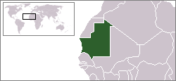
The Islamic Republic of Mauritania, or Mauritania, is a country in northwest Africa. The coast faces the Atlantic Ocean on the west, and Senegal lies to the southwest, Mali to the east and southeast, Algeria to the northeast, and the Moroccan-annexed territory of Western Sahara to the northwest. The country's population was just over three million in 2005 and its capital and largest city is Nouakchott, located on the Atlantic coast. The country is named after the ancient Berber kingdom of Mauretania.
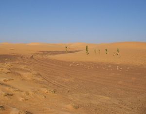
Mauritania is well-endowed with sand and barren soil and located on the western flank of the Sahara Desert. Though the interior contains mineral resources, the country's best-known exports may be the weather disturbances that form in the summer and fall, move offshore into warm ocean water, form cyclonic winds, head west for the Americas as tropical storms with assigned names, develop into hurricanes, and occasionally devastate islands and cities.
Mauritania sees itself as a link connecting the northern, Arab nations of North Africa's Maghreb and the sub-Saharan countries that make up the rest of the continent.
| |||||
| National motto: شرف إخاء عدل Honneur, Fraternité, Justice (Honor, Fraternity, Justice) | |||||

| |||||
| Principal languages | Arabic, French | ||||
| Capital | Nouakchott | ||||
| President of Military Council | Col. Ely Ould Mohamed Vall | ||||
| Prime Minister | Sidi Mohamed Ould Boubacar | ||||
| Area - Total |
Ranked 28th 1,030,700 km²(618,430 sq.m.) | ||||
| Population - Total (2005) - Density |
Ranked 129nd 3,086,859 2.6/km² | ||||
| Currency | Ouguiya | ||||
| Time zone | Universal Time +0 | ||||
| Independence | 1960 | ||||
| National anthem | National Anthem of Mauritania | ||||
| Internet TLD | .mr | ||||
| Country Calling Code | 222 | ||||
Geography
Mauritania is generally flat, its territory of over 1 million km²(618,000 square miles) forming vast, arid plains broken by occasional ridges and cliff-like outcroppings. A series of scarps face southwest, longitudinally bisecting these plains in the center of the country. The scarps also separate a series of sandstone plateaus, the highest of which is the Adrar Plateau, reaching an elevation of 500m (1.640 ft). Spring-fed oases lie at the foot of some of the scarps. Isolated peaks, often rich in minerals, rise above the plateaus; the smaller peaks are called guelbs and the larger ones kedias. The concentric Guelb er Richat is a prominent feature of the north-central region. Kediet Ijill, near the city of Zouîrât, has an elevation of 1,000m (3,280 ft) and is the highest peak.
Richat Structure, located in the Sahara Desert of Mauritania, at Gres de Chinguetti Plateau, has been a focus of world attention due to its bull's eye shape. The structure is 30 miles (50 kilometers) in diameter and has become a landmark for crews of the space shuttle. Once thought to be a meteorite impact structure, it is now considered to be a symmetrical uplift (circular anticline) laid bare by erosion.
History
From the third to seventh centuries C.E., the migration of Berber tribes from North Africa displaced the Bafours, the original inhabitants of present-day Mauritania and the ancestors of the Soninke. The Bafours were primarily agriculturalist, among the first Saharan people to abandon their historically nomadic lifestyle. With the gradual desiccation of the Sahara, they headed south. Following them came a migration of not only central Saharans into West Africa, but Berbers and Arabs as well. By the eleventh century, the once small Bafour people had grown into a very large and wealthy Soninke empire, later called the Ghana Empire,[1]which stretched from Mauritania into the neighboring states of Senegal and Mali. Likewise, in the north, the Arab-Berber population had achieved an impressive empire of its own, the territory of which stretched across the Mediterranean into Spain and Portugal. Local nomadic Berber tribes, though influential, remained largely without power, having been conquered by the Soninke.
In 1076, Islamic warrior monks (Almoravid, or Al Murabitun) attacked and conquered the ancient Ghana Empire. Over the next 500 years, Arabs overcame fierce resistance from the local population (Berber and non-Berber alike) and came to dominate Mauritania. The Mauritanian Thirty-Year War (1644-74) was the unsuccessful final effort to repel the Yemeni Maqil Arab invaders led by the Beni Hassan tribe. The descendants of the Yemeni Beni Hassan warriors became the upper stratum of Moorish society. Berbers retained influence by producing the majority of the region's Marabouts — those who preserve and teach Islamic tradition. Many of the Berber tribes proclaimed to be the origin of Yemen (as they sometimes did an Arab one). There is little evidence to suggest this, though some studies do make a connection between the two. Hassaniya, a mainly oral, Berber-influenced Arabic dialect that derives its name from the Yemeni Beni Hassan tribe, became the dominant language among the largely nomadic population. Aristocrat and servant castes developed, yielding "white" Moors (the aristocracy), kewri (the indigenous peoples who were never enslaved), and "black" Moors or haratin (the formerly enslaved).
French colonization at the beginning of the twentieth century brought legal prohibitions against slavery and an end to interclan warfare. During the colonial period, the population remained nomadic, but many sedentary peoples, whose ancestors had been expelled centuries earlier, began to trickle back into Mauritania. As the country gained independence in 1960, the capital of Nouakchott was founded at the site of a small colonial village, the Ksar, and 90 percent of the population was still nomadic. With independence, larger numbers of the indigenous peoples (Haalpulaar, Soninke, and Wolof) entered Mauritania, moving into the area north of the Senegal River. Educated in the French language and customs, many of these recent arrivals became clerks, soldiers, and administrators in the new state.
Moors reacted to this change by increasing pressure to Arabize many aspects of Mauritanian life, such as law and language. A schism developed between those who consider Mauritania to be an Arab country (mainly Moors) and those who seek a dominant role for the non-Moorish peoples. The discord between these two conflicting visions of Mauritanian society was evident during intercommunal violence that broke out in 1989 (the "1989 Events"), but has since subsided. The tension between these two visions remains a feature of the political dialog. A significant number from both groups, however, seek a more diverse, pluralistic society.
Politics
Mauritania's last presidential election, its third since adopting the democratic process in 1992, took place on November 7, 2003. Six candidates, including Mauritania's first female and first Haratine (former slave family) candidates, represented a wide variety of political goals and backgrounds. Incumbent President Maaouya Sid'Ahmed Taya won reelection with 67 percent of the popular vote while Mohamed Khouna Ould Haidalla finished second.
The PRDS, led by President Maaouya Ould Sid'Ahmed Taya, has dominated Mauritanian politics since the country's first multi-party elections in April 1992 following the approval by referendum of the current constitution in July 1991. President Taya, who won elections in 1992 and 1997, first became chief of state through a December 12, 1984 bloodless coup which made him chairman of the committee of military officers that governed Mauritania from July 1978 to April 1992. The country's first president, Moktar Ould Daddah, served from independence until ousted in a bloodless coup on July 10, 1978. A group of current and former Army officers launched a bloody but unsuccessful coup attempt on June 8, 2003. The ringleaders remain at large, and their exact motives remain unclear.
Politics in Mauritania have always been heavily influenced by personalities, with any leader's ability to exercise political power dependent upon control over resources; perceived ability or integrity; and tribal, ethnic, family, and personal considerations. Conflict between white Moor, black Moor, and non-Moor ethnic groups, centering on language, land tenure, and other issues, continues to be the dominant challenge to national unity.
In the recent news a coup d'Etat had occurred in August 3rd 2005, putting an end to a democracy in process. The African Union has suspended Mauritania from all organizational activities as the current government was not elected under the law of democracy.
Politics
Mauritania's 2003 presidential election was its third since adopting the democratic process in 1992. Six candidates, including Mauritania's first female and first haratin candidates, represented a wide variety of political goals and backgrounds. Incumbent President Maaouya Sid'Ahmed Taya won reelection with 67% of the popular vote.
The PRDS, led by President Taya, has dominated Mauritanian politics since the country's first multi-party elections. Taya, who won elections in 1992 and 1997, first became chief of state through a 1984 bloodless coup that made him chairman of the committee of military officers that governed Mauritania from 1978 to 1992. The country's first president, Moktar Ould Daddah, served from independence until ousted in a bloodless coup in 1978. A group of current and former army officers launched a bloody but unsuccessful coup attempt in 2003. The ringleaders remain at large, and their exact motives remain unclear.
The government bureaucracy is composed of traditional ministries, special agencies, and parastatal companies. The Ministry of Interior spearheads a system of regional governors and prefects modeled on the French system of local administration. Under this system, Mauritania is divided into 13 regions (wilaya), including the capital district, Nouakchott. Control is tightly concentrated in the executive branch of the central government, but a series of national and municipal elections since 1992 have produced some limited decentralization.
Political parties, illegal during the military period, were legalized again in 1991. By April 1992, as civilian rule returned, 16 major political parties had been recognized; 12 major parties were active in 2004. Most opposition parties boycotted the first legislative election in 1992, and for nearly a decade the parliament has been dominated by the PRDS. The opposition participated in municipal elections in 1994 and subsequent senatorial elections, most recently in 2004, gaining representation at the local level as well as three seats in the Senate.
Mauritania, along with Morocco, illegally annexed the territory of Western Sahara in 1976, with Mauritania taking the lower one-third. After several military losses to Polisario, Mauritania retreated in 1979, and their claims were taken by Morocco. Due to economic weakness, Mauritania has been a negligible player in the territorial dispute, with its official position being that it wishes for an expedient solution that is mutually agreeable to all parties.
Military coup
In August 2005, it was reported that the Mauritanian military, including members of the presidential guard, had seized control of key points in Nouakchott, indicating a possible coup against the government of President Taya, who was out of the country. The group of officers, calling itself the Military Council for Justice and Democracy, released the following statement: The national armed forces and security forces have unanimously decided to put a definitive end to the oppressive activities of the defunct authority, which our people have suffered from during the past years. (BBC)
The Military Council later issued another statement naming Colonel Ely Ould Mohamed Vall as president. Vall was himself once regarded as a firm ally of Taya, even aiding him in the original coup that brought him to power and serving as his security chief afterwards. This high-level betrayal of the former president suggests broad discontentment within the branches of local government, which is further supported by the seemingly complete lack of bloodshed.
The coup was condemned by most world authorities, but local political parties express hope that the Military Council will remain true to its word, and end its leadership after two years — hopefully leading to a democratic government.
The Military Council has subsequently released 115 political prisoners of the former government and authorized the return of Taya and some 300 of his political supporters.
Economy
- Mauritania and Madagascar are the only two countries in the world not to use decimal-based currency. The basic unit of currency, the ouguiya, is comprised of five khoums.
The Sahara region, is developing a modern economy centered on the exploitation of copper & iron-ore resources, it receives technical assistance & capitol investment from abroad.
The Sahel region still maintain the traditional economy subsistence of raising livestock, crafts, petty trading & agriculture.
More than 75% of Mauritanian population live by traditional economical practices, raising livestock, sheep & goats being most important.
Fishing & agriculture make up almost one- third of the GNP. Mining, contributes one-forth of the GNP, public administration contributes 15%.
Mauritania imposes indirect taxes on imports, turnover tax on exports & mining, taxes on vehicles, wages, salaries & cattle, service tax, & profits from industry & commercial concerns.
The goal of Mauritanian governments has been to increase the irrigation to the Senegal River valley to increase the production of rice, which to date they have had to rely on importing large quantities.
Demographics
Mauritania is a state in northwestern Africa, an area of 1,030,700 kilometers,(390,000 square miles), has the shape of a rectangle indented measuring 1,500 kilometers, (930 miles) from north to south & 680 miles east to west. Bordered to the northeast by Algeria, northwest by Western Sahara, to the southeast & east by Mali, & southwest by Senegal. To the west the Atlantic Ocean, extends 435 miles from Senegal River to the Cap Blanc Peninsula, northward.
Mauritania, North African Maghrib linked geographically which includes Morocco, Algeria & Tunisia, & the Senegal region of western Africa.
Part of western Sahara, a large proportion of Mauritania's population is nomadic.
Mauritania has large reserves of mineral wealth, such as copper, gypsum, & iron ore, which are being exploited now.
Mauritania became independent Nov.28, 1960. (Formerly French administered).
Islam is the official state religion. The republic guarantees religious freedom & freedom of conscience & liberty for all.
Official languages are Arabic & French.
Culture
Mauritania forms a cultural zone of transition between Arab-Berber region of North Africa & the southern region of the tropic of Cancer known as Sudan (derived from the Arabic bilad as - sudan, "land of the blacks").
Arab & Muslim heritage,the Moorish society are proud of their contributions of poetry, music & theology. Kewri societies have a varied rich folklore.
Communication, telephone, telegraph & mail services are all combined in main post offices. Mauritania has less than 15,000 telephones. International communications by telephone are run through Paris. Two satellite stations broadcast in French & Arabic.
Cultural History
In northern Mauritania, Stone Age remains have been discovered dating from Acheulian (Lower Paleolithic) & Neolithic periods.
External links
Government
News
Overviews
- Arab Gateway - Mauritania
- BBC News Country Profile - Mauritania
- CIA World Factbook - Mauritania
- Library of Congress Country Study - Mauritania data as of June 1988
Directories
- Columbia University Libraries - African Studies: Mauritania directory category
- Looksmart - Mauritania directory category
- Open Directory Project - Mauritania directory category
- Stanford University - Africa South of the Sahara: Mauritania directory category
- The Index on Africa - Mauritania directory category
- Yahoo! - Mauritania directory category
History
REFERENCES: http://earthobservatory.nasa.cov/NaturalHazards/natural_hazards_v2.php3?img_id=2124 Encyclopedia Britannica Online Reference Center Public Library Edition: Mauritania http://www.library.eb.com/eb/article-214465 http://www.library.eb.com/eb/article-55015 http://www.library.eb.com/eb/article-911079?tocId=9110759
Credits
New World Encyclopedia writers and editors rewrote and completed the Wikipedia article in accordance with New World Encyclopedia standards. This article abides by terms of the Creative Commons CC-by-sa 3.0 License (CC-by-sa), which may be used and disseminated with proper attribution. Credit is due under the terms of this license that can reference both the New World Encyclopedia contributors and the selfless volunteer contributors of the Wikimedia Foundation. To cite this article click here for a list of acceptable citing formats.The history of earlier contributions by wikipedians is accessible to researchers here:
The history of this article since it was imported to New World Encyclopedia:
Note: Some restrictions may apply to use of individual images which are separately licensed.


