Difference between revisions of "Jodhpur" - New World Encyclopedia
Nim Ruparel (talk | contribs) |
Nim Ruparel (talk | contribs) |
||
| Line 31: | Line 31: | ||
Jodhpur lies near the geographic center of [[Rajasthan]], which makes it a convenient base for travel in a region that is frequented by a large number of tourists. The old city of Jodhpur is surrounded by a thick [[stone wall]], which has six huge gates called Nagauri gate, Merati gate, Sojati gate, Jalori gate, Siwanchi gate and Chand pol. | Jodhpur lies near the geographic center of [[Rajasthan]], which makes it a convenient base for travel in a region that is frequented by a large number of tourists. The old city of Jodhpur is surrounded by a thick [[stone wall]], which has six huge gates called Nagauri gate, Merati gate, Sojati gate, Jalori gate, Siwanchi gate and Chand pol. | ||
| + | |||
| + | |||
== History == | == History == | ||
| − | [[Image:Jodhpur.svg|thumb|left|Flag of the princely state of Jodhpur]]Jodhpur was founded in [[1459]] by [[Rao Jodha]], a [[Rajput]] [[chief]] belonging to the [[Rathore]] [[clan]]. Rao Jodha succeeded in conquering the surrounding territory and thus founded a state which came to be known as [[Marwar]]. | + | [[Image:Jodhpur.svg|thumb|left|Flag of the princely state of Jodhpur]]Jodhpur was founded in [[1459]] by [[Rao Jodha]], a [[Rajput]] [[chief]] belonging to the [[Rathore]] [[clan]]. [[Rao Jodha]] succeeded in conquering the surrounding territory and thus founded a state which came to be known as [[Marwar]]. Since he hailed from the nearby town of [[Mandore]], that [[town]] initially served as the [[capital]] of this state, however, Jodhpur soon took over that role, and remained so during the remainder of [[Rao Jodha]]'s life. The city was located strategically on the road linking [[Delhi]] to [[Gujarat]], which enabled it to profit from a flourishing [[trade]] in [[opium]], [[copper]], [[silk]], [[Sandal (footwear)|sandal]]s, [[date palm]]s and [[coffee]]. |
| + | |||
[[Image:Jodhpur 5174663-66.jpg|thumb|left|Jodhpur [[Panorama]], spotted from the [[Mehrangarh Fort]].]] | [[Image:Jodhpur 5174663-66.jpg|thumb|left|Jodhpur [[Panorama]], spotted from the [[Mehrangarh Fort]].]] | ||
| − | Early in its history, the state became a [[fief]] under the [[ | + | Early in its history, the state became a [[fief]] under the [[Mughal Empire]], owing [[fealty]] to them while enjoying limited internal [[autonomy]]. During this period, the state furnished the [[Mughal Empire|Mughals]] with several notable [[general]]s such as [[Maharaja Jaswant Singh]]. Jodhpur and its people benefited from this exposure to the wider world through the introduction of new styles of [[art]] and [[architecture]] and the increased opportunities that opened up for local tradesmen to make their mark across northern [[India]]. |
| − | [[Aurangzeb]] briefly | + | The [[Mughal Empire|Mughal]] emperor [[Aurangzeb]] briefly retired the state in [[1679]] on the pretext of a minority, but the rightful ruler was restored to the throne after [[Aurangzeb]] died in [[1707]]. The [[Mughal Empire]] declined gradually after [[1707]], but the Jodhpur court was beset by intrigue. Rather than benefiting from these circumstances, Marwar descended into strife and invited the intervention of the [[Maratha]]s, who soon supplanted the [[Mughal Empire|Mughals]] as overlords of the region. However, this did not make for stability or peace, as 50 years of ruinous wars and humiliating treaties dissipated the wealth of the state, which sought and gratefully entered into a [[subsidiary alliance]] with the [[British East India Company|British]] in 1818. |
| − | During the [[British Raj]], the state of Jodhpur was the largest in Rajputana | + | During the [[British Raj]], the state of Jodhpur was the largest in Rajputana in terms of land area. The city prospered under the peace and stability of this era, and its merchants, the [[Marwari]]s, flourished and came to occupy a position of dominance in trade across India. In [[1947]], when India became independent, the state merged unto the [[union of India]] and Jodhpur became the second largest city in [[Rajasthan]]. |
==Geography== | ==Geography== | ||
| − | Jodhpur is located at {{coor d|26.29|N|73.03|E|}}<ref>[http://www.fallingrain.com/world/IN/24/Jodhpur.html Falling Rain Genomics, Inc - Jodhpur]</ref>. It has an average elevation of 232 [[ | + | Jodhpur is located at {{coor d|26.29|N|73.03|E|}}<ref>[http://www.fallingrain.com/world/IN/24/Jodhpur.html Falling Rain Genomics, Inc - Jodhpur]</ref>. It has an average elevation of 232 [[meter]]s (761 [[foot (unit of length)|feet]]). |
| − | |||
| − | |||
== Economy == | == Economy == | ||
| − | [[Image:2644438-lg.jpg|thumb| | + | [[Image:2644438-lg.jpg|thumb|right|Chili crop outside Jodhpur]] |
| − | |||
| − | + | The city serves as an important marketplace for wool and agricultural products. In terms of agriculture, the most prominent crops grown in Jodhpur include [[wheat]] and the famous ''Mathania'' red [[chillies]]. In addition, [[gypsum]] and [[salt]] are also mined. | |
| − | + | Much like other places in [[Rajasthan]], Jodhpur has become well known for its [[handicrafts]] industry, which has grown in recent years to become the most dominant industry in the city. | |
| − | + | By some estimates, the furniture export segment is a $200 million industry, directly or indirectly employing as many as 200,000 people. Other items manufactured include [[textiles]], [[metal]] utensils, [[bicycle]]s, [[ink]] and [[sporting good]]s. | |
| − | + | A flourishing cottage industry exists for the manufacture of such items as glass [[bangles]], [[cutlery]], [[carpets]] and [[marble]] products. | |
| − | + | The [[Indian Air Force]], [[Indian Army]] and [[Border Security Force]] maintain training centers at Jodhpur, likely because of the city's proximity to the border with [[Pakistan]]. | |
| − | |||
| − | |||
| − | |||
| − | |||
| − | |||
| − | The [[Indian Air Force]], [[Indian Army]] and [[Border Security Force]] maintain training centers at Jodhpur. | ||
==Demographics== | ==Demographics== | ||
| Line 71: | Line 65: | ||
==Education== | ==Education== | ||
| − | *[[Jai Narain Vyas University]] | + | *[[Jai Narain Vyas University]] |
| − | *[[National Law University | + | *[[National Law University]] |
| − | *[[Dr. S.N. Medical College | + | *[[Dr. S.N. Medical College]] |
| − | *[[MBM Engineering College]] | + | *[[MBM Engineering College]] |
== Historical and Cultural Sites == | == Historical and Cultural Sites == | ||
| Line 94: | Line 88: | ||
== Cuisine == | == Cuisine == | ||
A number of Indian delicacies have originated in Jodhpur . To name a few, the delectable [[Makhaniya Lassi]], Mawa Kachori, [[Pyaaj Kachori]], Hot & Spicy Mirchibada (A preparation made with potato, onion, chili and gramflour), [[Panchkuta]], lapsi (a special kind of desert made with wheat, gud (raw sugar), and ghee), kachar mircha curry (made with chili and kachar, a special type of vegetable grown in desert area) and Kadhi (made with gramflour, curd and chili). | A number of Indian delicacies have originated in Jodhpur . To name a few, the delectable [[Makhaniya Lassi]], Mawa Kachori, [[Pyaaj Kachori]], Hot & Spicy Mirchibada (A preparation made with potato, onion, chili and gramflour), [[Panchkuta]], lapsi (a special kind of desert made with wheat, gud (raw sugar), and ghee), kachar mircha curry (made with chili and kachar, a special type of vegetable grown in desert area) and Kadhi (made with gramflour, curd and chili). | ||
| + | |||
| + | == Transportation == | ||
| + | |||
| + | The airport in Jodhpur is only 5 km from the center of the city, and it has flights from [[Delhi]], [[Mumbai]], [[Udaipur]] and [[Jaipur]]. | ||
| + | |||
| + | The city is well connected by its railway lines, and trains are available from all of the major cities in the country into the city. | ||
| + | |||
| + | Along with this, buses and private luxury buses connect Jodhpur with almost all of the major locations in [[Rajasthan]]. | ||
| + | |||
| + | Other means of transport include [[taxi]]s, [[auto-rickshaw]]s, and tongas. In addition, the city is an excellent place to explore by [[bicycle]]. | ||
== References == | == References == | ||
| Line 100: | Line 104: | ||
==External links== | ==External links== | ||
| − | * [http://www.wikimapia.org/#y=26280641&x=73021209&z=16&l=0&m=a | + | * [http://jodhpur.nic.in/ Official Jodhpur Government Website] Retrieved December 22, 2007. |
| − | * [http://www.justicekansingh.org/jodhpur.htm | + | * [http://www.wikimapia.org/#y=26280641&x=73021209&z=16&l=0&m=a Zoomable map of Jodhpur] Retrieved December 22, 2007. |
| − | * [http://www.rajasthantourism.gov.in/ Rajasthan Tourism] | + | * [http://www.justicekansingh.org/jodhpur.htm Overview of Jodhpur] Retrieved December 22, 2007. |
| − | + | * [http://www.rajasthantourism.gov.in/ Rajasthan Tourism] Retrieved December 22, 2007. | |
| − | * [http://terragalleria.com/asia/india/jodhpur Photos of Jodhpur] | + | * [http://terragalleria.com/asia/india/jodhpur Photos of Jodhpur] Retrieved December 22, 2007. |
Revision as of 03:31, 22 December 2007
- This article is about the city in Rajasthan. For the city in Gujarat, see Jodhpur, Gujarat. For the riding breeches and boots, see Jodhpurs.
| Jodhpur Rajasthan • India | |
| Coordinates: | |
| Time zone | IST (UTC+5:30) |
| Area • Elevation |
75.50 km² (29 sq mi) • 231 m (758 ft) |
| District(s) | Jodhpur |
| Population • Density • Metro |
846,408[1] (2001) • 11,210 /km² (Expression error: Unrecognized punctuation character ",". /sq mi) • 951,000[2] (2005) |
| Mayor | Dr. Om Kumari Gehlot |
| Codes • Pincode • Telephone • Vehicle |
• 342001 • ++91-291 • RJ 19 |
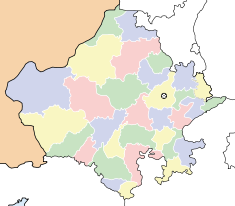
Coordinates: Jodhpur pronunciation ▶ (जोधपुर), is the second largest city in the state of Rajasthan in north India. It was formerly the seat of a princely state of the same name, also known as Marwar. Jodhpur is a popular tourist destination, featuring many beautiful palaces, forts and temples, as well as a stark, scenic desert landscape.
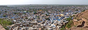
The city is known as the Sun City for the bright, sunny weather it enjoys all year. It is also referred as the Blue City, due to the indigo tinge of the whitewashed houses around the Mehrangarh Fort. The blue houses were originally for Brahmins, but non-Brahmins soon joined in, as the color was said to deflect the heat and keep mosquitoes away.
Jodhpur lies near the geographic center of Rajasthan, which makes it a convenient base for travel in a region that is frequented by a large number of tourists. The old city of Jodhpur is surrounded by a thick stone wall, which has six huge gates called Nagauri gate, Merati gate, Sojati gate, Jalori gate, Siwanchi gate and Chand pol.
History
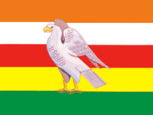
Jodhpur was founded in 1459 by Rao Jodha, a Rajput chief belonging to the Rathore clan. Rao Jodha succeeded in conquering the surrounding territory and thus founded a state which came to be known as Marwar. Since he hailed from the nearby town of Mandore, that town initially served as the capital of this state, however, Jodhpur soon took over that role, and remained so during the remainder of Rao Jodha's life. The city was located strategically on the road linking Delhi to Gujarat, which enabled it to profit from a flourishing trade in opium, copper, silk, sandals, date palms and coffee.
Early in its history, the state became a fief under the Mughal Empire, owing fealty to them while enjoying limited internal autonomy. During this period, the state furnished the Mughals with several notable generals such as Maharaja Jaswant Singh. Jodhpur and its people benefited from this exposure to the wider world through the introduction of new styles of art and architecture and the increased opportunities that opened up for local tradesmen to make their mark across northern India.
The Mughal emperor Aurangzeb briefly retired the state in 1679 on the pretext of a minority, but the rightful ruler was restored to the throne after Aurangzeb died in 1707. The Mughal Empire declined gradually after 1707, but the Jodhpur court was beset by intrigue. Rather than benefiting from these circumstances, Marwar descended into strife and invited the intervention of the Marathas, who soon supplanted the Mughals as overlords of the region. However, this did not make for stability or peace, as 50 years of ruinous wars and humiliating treaties dissipated the wealth of the state, which sought and gratefully entered into a subsidiary alliance with the British in 1818.
During the British Raj, the state of Jodhpur was the largest in Rajputana in terms of land area. The city prospered under the peace and stability of this era, and its merchants, the Marwaris, flourished and came to occupy a position of dominance in trade across India. In 1947, when India became independent, the state merged unto the union of India and Jodhpur became the second largest city in Rajasthan.
Geography
Jodhpur is located at [3]. It has an average elevation of 232 meters (761 feet).
Economy
The city serves as an important marketplace for wool and agricultural products. In terms of agriculture, the most prominent crops grown in Jodhpur include wheat and the famous Mathania red chillies. In addition, gypsum and salt are also mined.
Much like other places in Rajasthan, Jodhpur has become well known for its handicrafts industry, which has grown in recent years to become the most dominant industry in the city.
By some estimates, the furniture export segment is a $200 million industry, directly or indirectly employing as many as 200,000 people. Other items manufactured include textiles, metal utensils, bicycles, ink and sporting goods.
A flourishing cottage industry exists for the manufacture of such items as glass bangles, cutlery, carpets and marble products.
The Indian Air Force, Indian Army and Border Security Force maintain training centers at Jodhpur, likely because of the city's proximity to the border with Pakistan.
Demographics
As of 2001 India census[4], Jodhpur had a population of 846,408. Males constitute 53% of the population and females 47%. Jodhpur has an average literacy rate of 67%, higher than the national average of 59.5%: male literacy is 75%, and female literacy is 58%. In Jodhpur, 14% of the population is under 6 years of age.
Education
- Jai Narain Vyas University
- National Law University
- Dr. S.N. Medical College
- MBM Engineering College
Historical and Cultural Sites
A number of historical monuments dot the city and surrounding region. Some of these monuments are described here.
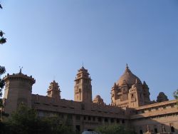
Umaid Bhawan Palace:The Umaid Bhawan Palace is not only one of India's most imposing palaces but also among its most recent. This lavish art deco monument to royal living had an improbable conception: it was built as a public relief and employment project during a long period of drought. Over one million square feet (90,000 m²) of the finest marble was used in the construction of the palace. A special type of sandstone, called Chittar sandstone, has been used in constructing the palace and this gives it a special effect. For this reason, it is also referred to as Chittar Palace by the locals. Its style of construction, with beautiful balconies, charming courtyards, green gardens and stately rooms, makes it a fine example of Indo-Saracenic architecture. The project employed three thousand artisans over a period of 15 years (1929-1943). The palace is named after its builder, Maharaja Umaid Singh (1876-1947), who was incidentally the president of the British Royal Institute of Architects. In 1977, the palace was segmented into the royal residence, the Heritage Hotel and a museum. Its 98 air-conditioned rooms are elegantly decorated with antique furniture as well as all the other amenities of a five star hotel.
Mehrangarh Fort: The Mehrangarh Fort lies at the outskirts of Jodhpur city and is located atop a 125 m high hill. The magnificent Mehrangarh Fort (Jodhpur ka kila) is the most majestic and one of the largest forts in India. It was originally started (c.1459) by Rao Jodha, founder of Jodhpur. However, most of the extant fort dates from the period of Jaswant Singh (1638-78). The walls of the fort are up to 36 m high and 21 m wide; they enclose some exquisite structures. The fort museum houses an exquisite collection of palanquins, howdahs, royal cradles, miniatures, musical instruments, costumes and furniture. The ramparts of Mehrangarh Fort provide not only excellently preserved cannons but also a breath-taking view of the city.
Jaswant Thada: The Jaswant Thada is architectural landmark found in Jodhpur. It is a white marble memorial built in 1899 in memory of Maharaja Jaswant Singh II. The monument, in its entirety, is built out of intricately carved sheets of marble. These stones are extremely thin and polished so that they emit a warm glow when the sun's rays dance across their surface. Within this cenotaph, there are also two more tombs.
Osiyan Temple: An ancient Jain temple, well worth the visit, lies in the village of Osiyan, about 60 km outside Jodhpur. There are many sections of this temple, which was built in several distinct phases.
Kaman art gallery: The Kaman art gallery is indian contemporary art gallery .It is first contemporary art gallery in rajasthan .There are see many famous indian contemporary artists painting.This gallery location near clock tower jodhpur,Old fort Road,kili khana.
Cuisine
A number of Indian delicacies have originated in Jodhpur . To name a few, the delectable Makhaniya Lassi, Mawa Kachori, Pyaaj Kachori, Hot & Spicy Mirchibada (A preparation made with potato, onion, chili and gramflour), Panchkuta, lapsi (a special kind of desert made with wheat, gud (raw sugar), and ghee), kachar mircha curry (made with chili and kachar, a special type of vegetable grown in desert area) and Kadhi (made with gramflour, curd and chili).
Transportation
The airport in Jodhpur is only 5 km from the center of the city, and it has flights from Delhi, Mumbai, Udaipur and Jaipur.
The city is well connected by its railway lines, and trains are available from all of the major cities in the country into the city.
Along with this, buses and private luxury buses connect Jodhpur with almost all of the major locations in Rajasthan.
Other means of transport include taxis, auto-rickshaws, and tongas. In addition, the city is an excellent place to explore by bicycle.
ReferencesISBN links support NWE through referral fees
External links
- Official Jodhpur Government Website Retrieved December 22, 2007.
- Zoomable map of Jodhpur Retrieved December 22, 2007.
- Overview of Jodhpur Retrieved December 22, 2007.
- Rajasthan Tourism Retrieved December 22, 2007.
- Photos of Jodhpur Retrieved December 22, 2007.
| State of Rajasthan Rajasthan Topics | |
|---|---|
| Capital | Jaipur |
| Divisions | Ajmer | Bharatpur | Bikaner | Jaipur | Jodhpur | Kota | Udaipur |
| Districts | Ajmer | Alwar | Banswara | Baran | Barmer | Bhilwara | Bikaner | Bharatpur | Bundi | Chittorgarh | Churu | Dausa | Dholpur | Dungarpur | Ganganagar | Hanumangarh | Jaipur | Jaisalmer | Jalore | Jhalawar | Jhunjhunu | Jodhpur | Karauli | Kota | Nagaur | Pali | Rajsamand | Sawai Madhopur | Sikar | Sirohi | Tonk | Udaipur |
| Major cities | Alwar • Bhilwara • Bikaner • Jaipur • Jaisalmer • Jodhpur • Udaipur |
Credits
New World Encyclopedia writers and editors rewrote and completed the Wikipedia article in accordance with New World Encyclopedia standards. This article abides by terms of the Creative Commons CC-by-sa 3.0 License (CC-by-sa), which may be used and disseminated with proper attribution. Credit is due under the terms of this license that can reference both the New World Encyclopedia contributors and the selfless volunteer contributors of the Wikimedia Foundation. To cite this article click here for a list of acceptable citing formats.The history of earlier contributions by wikipedians is accessible to researchers here:
The history of this article since it was imported to New World Encyclopedia:
Note: Some restrictions may apply to use of individual images which are separately licensed.


