Difference between revisions of "French Guiana" - New World Encyclopedia
m (Rename to Geography) |
Vicki Phelps (talk | contribs) |
||
| Line 8: | Line 8: | ||
| image_logo_size = 100px | | image_logo_size = 100px | ||
| flag = Region flag | | flag = Region flag | ||
| − | | capital = | + | | capital = Cayenne |
| area = 83,534 | | area = 83,534 | ||
| area_scale = 10 | | area_scale = 10 | ||
| − | | Regional president = | + | | Regional president = Antoine Karam<br/>(PSG) (since 1992) |
| population_rank = 26th | | population_rank = 26th | ||
| population_census = 157,213 | | population_census = 157,213 | ||
| Line 27: | Line 27: | ||
| footnotes = | | footnotes = | ||
}} | }} | ||
| − | '''French Guiana''' | + | '''French Guiana''' is an overseas department of [[France]], located on the northern coast of [[South America]]. Like the others, French Guiana is also an overseas region of France, one of the 26 regions of France. As a part of France, French Guiana is part of the [[European Union]]'s territory, and its currency is the [[euro]]. |
| + | == Geography == | ||
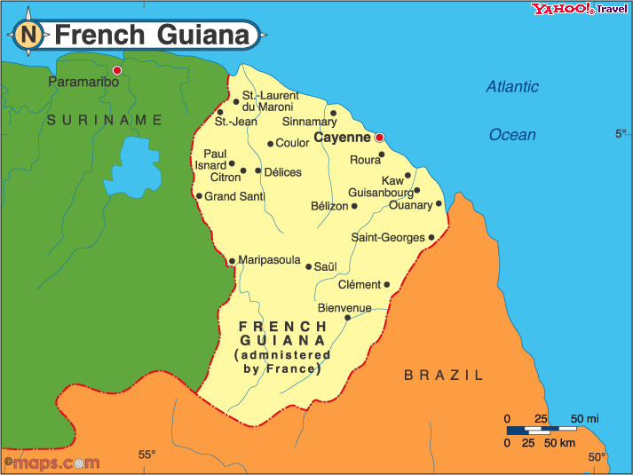
| + | [[Image:French Guiana CIA.gif|right|Map Of French Guiana]] | ||
| + | Though sharing cultural affinities with the French-speaking territories of the [[Caribbean]], French Guiana cannot be considered to be part of that geographic region, with the Caribbean Sea actually being several hundred kilometers to the west, beyond the arc of the [[Lesser Antilles]]. | ||
| + | |||
| + | French Guiana consists of two main geographical regions: a coastal strip where the majority of the people live, and dense, near-inaccessible [[rainforest]] which gradually rises to the modest peaks of the Tumac-Humac mountains along the Brazilian frontier. French Guiana's highest peak is Bellevue de l'Inini (851 m). Other mountains include Mont Machalou (782 m), Pic Coudreau (711 m) and Mont St Marcel (635 m), Mont Favard (200 m) and Montagne du Mahury (156 m). Several small islands are found off the coast, the three Iles du Salut Salvation Islands which includes Devil's Island and the isolated Ile de Connetable bird sanctuary further along the coast toward Brazil. | ||
| + | |||
| + | The Barrage de Petit-Saut hydroelectric dam in the north of French Guiana forms an artificial lake and provides [[hydroelectricity]]. There are many rivers in French Guiana. | ||
==History== | ==History== | ||
The '''history of [[French Guiana]]''' spans many centuries. Before the first Europeans arrived, there was no written history in the territory. It was originally inhabited by a number of Native American peoples, among them the [[Carib]], [[Arawak]], [[Emerillon]], [[Galibi]], [[Palikour]], [[Wayampi]] (also known as Oyampi) and [[Wayana]]. The first Europeans arrived in the expeditions of [[Christopher Columbus]], shortly before 1500. | The '''history of [[French Guiana]]''' spans many centuries. Before the first Europeans arrived, there was no written history in the territory. It was originally inhabited by a number of Native American peoples, among them the [[Carib]], [[Arawak]], [[Emerillon]], [[Galibi]], [[Palikour]], [[Wayampi]] (also known as Oyampi) and [[Wayana]]. The first Europeans arrived in the expeditions of [[Christopher Columbus]], shortly before 1500. | ||
| Line 85: | Line 92: | ||
A chronic issue affecting French Guiana is the influx of illegal immigrants and clandestine [[gold prospecting|gold prospectors]] from [[Brazil]] and [[Suriname]]. The border between the department and Suriname is formed by the [[Maroni River]], which flows through rain forest and is difficult for the [[Gendarmerie Nationale (France)|Gendarmerie]] and the [[French Foreign Legion]] to patrol. The border line with Suriname is disputed. | A chronic issue affecting French Guiana is the influx of illegal immigrants and clandestine [[gold prospecting|gold prospectors]] from [[Brazil]] and [[Suriname]]. The border between the department and Suriname is formed by the [[Maroni River]], which flows through rain forest and is difficult for the [[Gendarmerie Nationale (France)|Gendarmerie]] and the [[French Foreign Legion]] to patrol. The border line with Suriname is disputed. | ||
| − | |||
| − | |||
| − | |||
| − | |||
| − | |||
| − | |||
| − | |||
== Economy == | == Economy == | ||
| Line 101: | Line 101: | ||
French Guiana's main international airport is [[Cayenne-Rochambeau Airport]], located in the [[communes of France|commune]] of [[Matoury]], a southern suburb of [[Cayenne]]. There is one flight a day to [[Paris]] ([[Orly Airport]]), and one flight a day arriving from Paris. The flight time from Cayenne to Paris is 8 hours and 25 minutes, and from Paris to Cayenne it is 9 hours and 10 minutes. There are also flights to [[Fort-de-France]], [[Pointe-à-Pitre]], [[Port-au-Prince]], [[Miami]], [[Macapá]], [[Belém]], and [[Fortaleza]]. | French Guiana's main international airport is [[Cayenne-Rochambeau Airport]], located in the [[communes of France|commune]] of [[Matoury]], a southern suburb of [[Cayenne]]. There is one flight a day to [[Paris]] ([[Orly Airport]]), and one flight a day arriving from Paris. The flight time from Cayenne to Paris is 8 hours and 25 minutes, and from Paris to Cayenne it is 9 hours and 10 minutes. There are also flights to [[Fort-de-France]], [[Pointe-à-Pitre]], [[Port-au-Prince]], [[Miami]], [[Macapá]], [[Belém]], and [[Fortaleza]]. | ||
| − | French Guiana's main seaport is the port of [[Dégrad des Cannes]], located on the [[estuary]] of the [[Mahury River]], in the commune of [[Remire-Montjoly]], a south-eastern suburb of Cayenne. Almost all of French Guiana's imports and exports pass through the port of Dégrad des Cannes. Built in | + | French Guiana's main seaport is the port of [[Dégrad des Cannes]], located on the [[estuary]] of the [[Mahury River]], in the commune of [[Remire-Montjoly]], a south-eastern suburb of Cayenne. Almost all of French Guiana's imports and exports pass through the port of Dégrad des Cannes. Built in 1969, it replaced the old harbor of Cayenne which was congested and couldn't cope with modern traffic. |
| − | An [[Pavement (material)#Asphalt paving|asphalted]] road from [[Régina]] to [[Saint-Georges de l'Oyapock]] (a town by the [[Brazil]]ian border) was opened in | + | An [[Pavement (material)#Asphalt paving|asphalted]] road from [[Régina]] to [[Saint-Georges de l'Oyapock]] (a town by the [[Brazil]]ian border) was opened in 2004, completing the road from Cayenne to the Brazilian border. It is now possible to drive on a fully paved road from [[Saint-Laurent-du-Maroni]] on the [[Suriname]]se border to Saint-Georges de l'Oyapock on the Brazilian border. Following an international treaty between France and Brazil signed in July 2005, a bridge over the [[Oyapock River]] (marking the border with Brazil) is currently being built and is due to open in the end of 2008. This bridge will be the first land crossing ever opened between France and Brazil, and indeed between French Guiana and the rest of the world (there exists no other bridge crossing the Oyapock River, and no bridge crossing the [[Maroni River]] marking the border with Suriname). When the bridge is opened, it will be possible to drive uninterrupted from Cayenne to [[Macapá]], the capital of the state of [[Amapá]] in Brazil. |
== Demographics == | == Demographics == | ||
{{main|Demographics of French Guiana}} | {{main|Demographics of French Guiana}} | ||
| − | French Guiana's population of 202,000 ( | + | French Guiana's population of 202,000 (January 2006 est.),<ref>{{fr icon}} {{cite web| url=http://www.insee.fr/fr/recensement/nouv_recens/resultats/resultats-regionaux.htm| title="Estimations de population régionale au 1er janvier 2006"| first=Government of France| last=INSEE| accessdate=2007-05-04}}</ref> most of whom live along the coast, is very ethnically diverse. At the 1999 census, 54.4% of the inhabitants of French Guiana were born in French Guiana, 11.8% were born in [[Metropolitan France]], 5.2% were born in the French [[Caribbean]] ''[[departments of France|départements]]'' ([[Guadeloupe]] and [[Martinique]]), and 28.6% were born in foreign countries (most notably [[Brazil]], [[Suriname]], and [[Haiti]]).<ref>{{fr icon}} {{cite web| url=http://www.recensement.insee.fr/FR/ST_ANA/D9C/MIGTABMIG1DOMMIG1DOMAD9CFR.html| title="Migrations (caractéristiques démographiques selon le lieu de naissance)"| first=Government of France| last=INSEE| accessdate=2007-05-04}}</ref> |
French censuses do not record ethnicity, so estimates of the percentages of French Guiana ethnic composition vary, a problem compounded by the large numbers of legal and illegal immigrants (about 20,000). | French censuses do not record ethnicity, so estimates of the percentages of French Guiana ethnic composition vary, a problem compounded by the large numbers of legal and illegal immigrants (about 20,000). | ||
| Line 124: | Line 124: | ||
{| align="center" rules="all" cellspacing="0" cellpadding="4" style="border: 1px solid #999; border-right: 2px solid #999; border-bottom:2px solid #999; background: #f3fff3" | {| align="center" rules="all" cellspacing="0" cellpadding="4" style="border: 1px solid #999; border-right: 2px solid #999; border-bottom:2px solid #999; background: #f3fff3" | ||
|+ style="font-weight: bold; font-size: 1.1em; margin-bottom: 0.5em"| Historical population | |+ style="font-weight: bold; font-size: 1.1em; margin-bottom: 0.5em"| Historical population | ||
| − | ! | + | ! 1790<br/>estimate !! 1839<br/>estimate !! 1857<br/>estimate !! 1891<br/>estimate !! 1946<br/>census !! 1954<br/>census !! 1961<br/>census !! 1967<br/>census !! 1974<br/>census !! 1982<br/>census !! 1990<br/>census !! 1999<br/>census !! 2006<br/>estimate |
|- | |- | ||
| align=center| 14,520 || align=center| 20,940 || align=center| 25,561 || align=center| 33,500 || align=center| 25,499 || align=center| 27,863|| align=center| 33,505 || align=center| 44,392 || align=center| 55,125 || align=center| 73,022 || align=center| 114,678 || align=center| 157,213 || align=center| 202,000 | | align=center| 14,520 || align=center| 20,940 || align=center| 25,561 || align=center| 33,500 || align=center| 25,499 || align=center| 27,863|| align=center| 33,505 || align=center| 44,392 || align=center| 55,125 || align=center| 73,022 || align=center| 114,678 || align=center| 157,213 || align=center| 202,000 | ||
Revision as of 15:59, 18 December 2007
| Région Guyane | ||
|---|---|---|
|
Logo of Guyane | |
| (Region flag) | (Region logo) | |
| Location | ||
| ||
| Administration | ||
| Capital | Cayenne | |
| Regional President | Antoine Karam (PSG) (since 1992) | |
| Departments | Guyane | |
| Arrondissements | 2 | |
| Cantons | 19 | |
| Communes | 22 | |
| Statistics | ||
| Land area1 | 83,534 km² | |
| Population | (Ranked 26th) | |
| - January 1, 2006 est. | 202,000 | |
| - March 8, 1999 census | 157,213 | |
| - Density (2006) | 2.4/km² | |
| 1 French Land Register data, which exclude lakes, ponds, and glaciers larger than 1 km² (0.386 sq. mi. or 247 acres) as well as the estuaries of rivers | ||


French Guiana is an overseas department of France, located on the northern coast of South America. Like the others, French Guiana is also an overseas region of France, one of the 26 regions of France. As a part of France, French Guiana is part of the European Union's territory, and its currency is the euro.
Geography

Though sharing cultural affinities with the French-speaking territories of the Caribbean, French Guiana cannot be considered to be part of that geographic region, with the Caribbean Sea actually being several hundred kilometers to the west, beyond the arc of the Lesser Antilles.
French Guiana consists of two main geographical regions: a coastal strip where the majority of the people live, and dense, near-inaccessible rainforest which gradually rises to the modest peaks of the Tumac-Humac mountains along the Brazilian frontier. French Guiana's highest peak is Bellevue de l'Inini (851 m). Other mountains include Mont Machalou (782 m), Pic Coudreau (711 m) and Mont St Marcel (635 m), Mont Favard (200 m) and Montagne du Mahury (156 m). Several small islands are found off the coast, the three Iles du Salut Salvation Islands which includes Devil's Island and the isolated Ile de Connetable bird sanctuary further along the coast toward Brazil.
The Barrage de Petit-Saut hydroelectric dam in the north of French Guiana forms an artificial lake and provides hydroelectricity. There are many rivers in French Guiana.
History
The history of French Guiana spans many centuries. Before the first Europeans arrived, there was no written history in the territory. It was originally inhabited by a number of Native American peoples, among them the Carib, Arawak, Emerillon, Galibi, Palikour, Wayampi (also known as Oyampi) and Wayana. The first Europeans arrived in the expeditions of Christopher Columbus, shortly before 1500.
Beginnings of European involvement
In 1498 French Guiana was first visited by Europeans when Christopher Columbus sailed to the region and named it the "Land of pariahs." In 1604 France attempted to settle in the area, but was forced to abandon it in the face of hostility from the Portuguese, who viewed it as a violation of the Treaty of Tordesillas. French settlers returned, however, in 1643 and managed to establish a settlement at Cayenne along with some small-scale plantations. This second attempt would again be abandoned following Amerindian attacks. The French returned once more in 1664, and founded a second settlement at Sinnamary (this was attacked by the Dutch in 1665).
In 1667 the British seized the area. Following the Treaty of Breda on 31st July 1667 the area was given back to France. The Dutch briefly occupied it for a period in 1676.
Consolidation of French rule
After the Treaty of Paris in 1763, which deprived France of almost all her possessions in the Americas other than Guiana and a few islands, Louis XV sent thousands of settlers to Guiana who were lured there with stories of plentiful gold and easy fortunes to be made. Instead they found a land filled with hostile natives and tropical diseases. One and a half years later only a few hundred survived. These fled to three small islands which could be seen off shore and named them the Iles de Salut (or "Islands of Salvation"). The largest was called Royal Island, another St. Joseph (after the patron saint of the expedition), and the smallest of the islands, surrounded by strong currents, Île du Diable (the infamous "Devil's Island"). When the survivors of this ill-fated expedition returned home, the terrible stories they told of the colony left a lasting impression in France.
In 1794, after the death of Robespierre, 193 of his followers were sent to French Guiana. In 1797 the republican general Pichegru and many deputies and journalists were also sent to the colony. When they arrived they found that only 54 of the 193 deportées sent out three years earlier were left; 11 had escaped, and the rest had died of tropical fevers and other diseases. Pichegru managed to escape to United States and then returned to France where he was eventually executed for plotting against Napoleon.
Later on, slaves were brought out from Africa and plantations were established along the more disease-free rivers. Exports of sugar, hardwood, Cayenne pepper and other spices brought a certain prosperity to the colony for the first time. Cayenne, the capital, was surrounded by plantations, some of which had several thousand slaves.
1800s and the penal era
In 1809 an Anglo-Portuguese naval squadron took French Guiana (ousting governor Victor Hugues) and gave it to the Portuguese in Brazil. However with the signing of the Treaty of Paris in 1814 the region was handed back to the French, though a Portuguese presence remained until 1817.
In 1848 France abolished slavery and the ex-slaves fled into the rainforest setting up communities similar to the ones they had been stolen from in Africa. Now called Maroons, they formed a sort of buffer zone between the Europeans who settled along the coast and main rivers, and the unconquered, and often hostile, Native American tribes of the inland regions. Without the availability of slave labour the plantations were soon taken over by the jungle, and the planters ruined.
In 1850 several shiploads of Indians, Malays and Chinese were brought out to work the plantations but, instead, they set up shops in Cayenne and other settlements.

In 1852 the first shiploads of chained convicts arrived from France. In 1885, to get rid of habitual criminals and to increase the number of colonists, the French Parliament passed a law that anyone, male or female, who had more than three sentences for theft of more than three months each, would be sent to French Guiana as a "relégué." These relégués were to be kept in prison there for six months but then freed to become settlers in the colony. However, this experiment was a dismal failure. The prisoners were unable to make a living off the land and so were forced to revert again to crime, or to eke out a hand-to-mouth existence until they died. In fact, being sent to French Guiana as a relégué was a life sentence, and usually a short life sentence, as most of the relégués died very quickly from disease and malnutrition. The prisoners would arrive at St-Laurent du Maroni before being transported to various camps throughout the country. The Iles du Salut were used to house political prisoners and for solitary confinement. The islands became notorious for the brutality of life there, centering around the notorious Devil's Island. Famous political figures to be sent to the islands included Alfred Dreyfus and Henri Charrière, who managed to escape. He later wrote a best-selling book about his experiences called Papillon.

In 1853, gold was discovered in the interior, precipitating border disputes with Brazil and Dutch Guiana (these were later settled in 1891, 1899 and 1915, though a small region of the border with Suriname is still disputed).
20th century
The territory of Inini, consisting of most of the interior of French Guiana, was created in 1930. It was abolished in 1946.
After the fall of France to Nazis in World War II the local government declared its allegiance to the Vichy government, despite widespread support for Charles de Gaulle. This government was later removed by the Allies in March 1943.
French Guiana became an overseas département of France on 19 March, 1946.
The infamous penal colonies, including Devil's Island, were gradually phased out and then formally closed in 1951. At first, only those freed prisoners who could raise the fare for their return passage to France were able to go home, so French Guiana was haunted after the official closing of the prisons by numerous freed convicts leading an aimless existence in the colony.
Visitors to the site in December 1954 reported being deeply shocked by the conditions and the constant screams from the cell-block still in use for convicts who had gone insane and which had only tiny ventilation slots at the tops of the walls under the roof. Food was pushed in and bodies removed once a day.
In 1964 Kourou was chosen to be launch site for rockets, largely due to its favourable location near the equator. The Guiana Space Center was built and became operational in 1968. This has provided limited local employment and the mainly foreign technicians, and hundreds of troops stationed in the region to prevent sabotage, bring income to the local economy.
The 1970s saw the settlement of Hmong refugees from Laos in the county, primarily to the towns of Javouhuy and Cacao. The Green Plan (Plan Vert) of 1976 aimed to improve production, though it had only limited success. A movement for increased autonomy from France gained momentum in the 70's and 80's, along with the increasing success of the Parti Socialiste Guyanais.
Protests by those calling for more autonomy from France have become increasingly vocal. Protests in 1996, 1997 and 2000 all ended in violence. While many Guianese wish to see more autonomy, support for complete independence is low due to large economic support from France.
Politics
French Guiana, as part of France, is part of the European Union, the largest part in area outside Europe, with one of the longest EU external boundaries. Along with the Spanish enclaves in Africa of Ceuta and Melilla, it is one of only three EU territories outside Europe that is not an island. Its head of state is the President of the French Republic, who appoints a Prefect (resident at the Prefecture building in Cayenne) as his representative. There are two legislative bodies: the 19-member General Council and the 34-member Regional Council, both elected. French Guiana has two seats at the National Assembly in Paris. French Guiana has traditionally been conservative, though the socialist party has been increasingly successful in recent years. Though many would like to see more autonomy for the region, support for complete independence is very low.
A chronic issue affecting French Guiana is the influx of illegal immigrants and clandestine gold prospectors from Brazil and Suriname. The border between the department and Suriname is formed by the Maroni River, which flows through rain forest and is difficult for the Gendarmerie and the French Foreign Legion to patrol. The border line with Suriname is disputed.
Economy
French Guiana is heavily dependent on France for subsidies and goods. The main industries are fishing (accounting for three-quarters of foreign exports), gold mining and timber. In addition, the Guiana Space Center at Kourou accounts for 25% of the GDP and employs about 1700 people. There is very little manufacturing and agriculture is largely undeveloped. Tourism, especially eco-tourism, is growing. Unemployment is a major problem, running at about 20% to 30%. In 2004 the GDP per capita of French Guiana at real exchange rates, not at PPP, was 12,887 euros (US$16,030), which was 59.9% of the European Union's average GDP per capita that year.[1]
Transportation
French Guiana's main international airport is Cayenne-Rochambeau Airport, located in the commune of Matoury, a southern suburb of Cayenne. There is one flight a day to Paris (Orly Airport), and one flight a day arriving from Paris. The flight time from Cayenne to Paris is 8 hours and 25 minutes, and from Paris to Cayenne it is 9 hours and 10 minutes. There are also flights to Fort-de-France, Pointe-à-Pitre, Port-au-Prince, Miami, Macapá, Belém, and Fortaleza.
French Guiana's main seaport is the port of Dégrad des Cannes, located on the estuary of the Mahury River, in the commune of Remire-Montjoly, a south-eastern suburb of Cayenne. Almost all of French Guiana's imports and exports pass through the port of Dégrad des Cannes. Built in 1969, it replaced the old harbor of Cayenne which was congested and couldn't cope with modern traffic.
An asphalted road from Régina to Saint-Georges de l'Oyapock (a town by the Brazilian border) was opened in 2004, completing the road from Cayenne to the Brazilian border. It is now possible to drive on a fully paved road from Saint-Laurent-du-Maroni on the Surinamese border to Saint-Georges de l'Oyapock on the Brazilian border. Following an international treaty between France and Brazil signed in July 2005, a bridge over the Oyapock River (marking the border with Brazil) is currently being built and is due to open in the end of 2008. This bridge will be the first land crossing ever opened between France and Brazil, and indeed between French Guiana and the rest of the world (there exists no other bridge crossing the Oyapock River, and no bridge crossing the Maroni River marking the border with Suriname). When the bridge is opened, it will be possible to drive uninterrupted from Cayenne to Macapá, the capital of the state of Amapá in Brazil.
Demographics
French Guiana's population of 202,000 (January 2006 est.),[2] most of whom live along the coast, is very ethnically diverse. At the 1999 census, 54.4% of the inhabitants of French Guiana were born in French Guiana, 11.8% were born in Metropolitan France, 5.2% were born in the French Caribbean départements (Guadeloupe and Martinique), and 28.6% were born in foreign countries (most notably Brazil, Suriname, and Haiti).[3]
French censuses do not record ethnicity, so estimates of the percentages of French Guiana ethnic composition vary, a problem compounded by the large numbers of legal and illegal immigrants (about 20,000).
Guianese Creoles (People of primarily African heritage mixed with some French ancestry) are the largest ethnic group, though estimates vary as to the exact percentage, depending upon whether the large Haitian community is included as well. Generally the Creole population is judged at about 60% to 70% of the total population with Haitians (comprising roughly one-third of Creoles) and 30% to 50% without. Roughly 14% are Europeans, the vast majority of whom are French.
The main Asian communities are the Hmong from Laos (1.5%) and Chinese (3.2%, primarily from Hong Kong and Zhejiang province). There are also smaller groups from various Caribbean islands, mainly Saint Lucia. The main groups living in the interior are the Maroons (also called Bush Negroes) and Amerindians.
The Maroons, descendants of escaped African slaves, live primarily along the Maroni River. The main Maroon groups are the Paramacca, Aucan (both of whom also live in Suriname) and the Boni (Aluku).
The main Amerindian groups (forming about 3%-4% of the population) are the Arawak, Emerillon, Galibi (now called the Kaliña), Palikour, Wayampi (also known as Oyampi) and Wayana.
The predominant religion in this region is Roman Catholicism, though the Maroons and some Amerindian peoples still practice their own religions. The Hmong people are also mainly Catholic owing to the influence of Catholic missionaries who helped bring them to French Guiana.[4]
| 1790 estimate |
1839 estimate |
1857 estimate |
1891 estimate |
1946 census |
1954 census |
1961 census |
1967 census |
1974 census |
1982 census |
1990 census |
1999 census |
2006 estimate |
|---|---|---|---|---|---|---|---|---|---|---|---|---|
| 14,520 | 20,940 | 25,561 | 33,500 | 25,499 | 27,863 | 33,505 | 44,392 | 55,125 | 73,022 | 114,678 | 157,213 | 202,000 |
| Official figures from past censuses and INSEE estimates. | ||||||||||||
Notable People
- Florent Malouda, French international football player.
- Henri Charrière, an escaped French convict, imprisoned in and around French Guiana from 1933 to 1945.
- Malia Metella, French swimmer, SC European Championships 2004: 1st 100m free.
- Bernard Lama, former French international football player.
- Cyrille Regis, former West Bromwich Albion and England player.
- Léon Damas, Francophone poet widely notated for his influence on the literary movement known as la négritude
- Henri Salvador, famous singer, one of the inspiration sources for the Bossa Nova movement.
- Jean-Claude Darcheville, football striker who joined Rangers from FC Girondins de Bordeaux in the summer of 2007.
ReferencesISBN links support NWE through referral fees
- ↑ Eurostat. Regional GDP per inhabitant in the EU27 (PDF). Retrieved 2007-06-09.
- ↑ (French) INSEE, Government of France. "Estimations de population régionale au 1er janvier 2006". Retrieved 2007-05-04.
- ↑ (French) INSEE, Government of France. "Migrations (caractéristiques démographiques selon le lieu de naissance)". Retrieved 2007-05-04.
- ↑ Danny Palmerlee (2007). South America. Lonely Planet. ISBN 174104443X.
Sources and further reading
- France's Overseas Frontier : Départements et territoires d'outre-mer Robert Aldrich and John Connell. Cambridge University Press, 2006. ISBN 0-521-03036-6
- Dry guillotine: Fifteen years among the living dead René Belbenoit, 1938, Reprint: Berkley (1975). ISBN 0-425-02950-6
- Hell on Trial René Belbenoit, 1940, Translated from the Original French Manuscript by Preston Rambo. E. P Dutton & Co. Reprint by Blue Ribbon Books, New York, 194 p. Reprint: Bantam Books, 1971
- Papillon Henri Charrière Reprints: Hart-Davis Macgibbon Ltd. 1970. ISBN 0-246-63987-3 (hbk); Perennial, 2001. ISBN 0-06-093479-4 (sbk)
- Space in the Tropics: From Convicts to Rockets in French Guiana Peter Redfield. ISBN 0-520-21985-6
- Belebenoit, René. 1940. Hell on Trial. Translated from the Original French Manuscript by Preston Rambo. E. P Dutton & Co. Reprint by Blue Ribbon Books, New York, 1941.
- Belbenoit, René. 1938. Dry Guillotine: Fifteen years among the living dead. Reprint: Berkley (1975). ISBN 0-425-02950-6. Reprint: Bantam Books, 1971.
- Charrière, Henri. Papillon. Reprints: Hart-Davis Macgibbon Ltd. 1970. ISBN 0-246-63987-3 (hbk); Perennial, 2001. ISBN 0-06-093479-4
- Tissot, Jean-Michel: La Guyane telle quelle, Paris (Le Créations du Pélican) 1998. ISBN 2-7191-0379-9
External links
- General information
- Conseil régional de Guyane Official website
- Gabe's French Guiana with information and many photos
- {{{2}}} at the Open Directory Project
- US Consular Information Sheet
- Other
- Ethnologue French Guiana page
- Silvolab Guyanae - scientific interest group in French Guiana
- Article on separatism in French Guiana
- About.com French Guiana travel site
- Status of Forests in French Guiana
- French Guiana photo gallery
- French Guiana image gallery
- Photo gallery
- Map of French Guiana
- Officials reports, thesis, scientific papers about French Guiana (en|fr)
- The IRD's database AUBLET2 stores information about botanical specimens collected in the Guianas, mainly in French Guiana
Credits
New World Encyclopedia writers and editors rewrote and completed the Wikipedia article in accordance with New World Encyclopedia standards. This article abides by terms of the Creative Commons CC-by-sa 3.0 License (CC-by-sa), which may be used and disseminated with proper attribution. Credit is due under the terms of this license that can reference both the New World Encyclopedia contributors and the selfless volunteer contributors of the Wikimedia Foundation. To cite this article click here for a list of acceptable citing formats.The history of earlier contributions by wikipedians is accessible to researchers here:
The history of this article since it was imported to New World Encyclopedia:
Note: Some restrictions may apply to use of individual images which are separately licensed.