Difference between revisions of "Oahu" - New World Encyclopedia
(Import, credit and version.) |
(Fixed) |
||
| Line 17: | Line 17: | ||
| rank = 3rd largest [[Hawaiian Islands|Hawaiian Island]] | | rank = 3rd largest [[Hawaiian Islands|Hawaiian Island]] | ||
}} | }} | ||
| − | '''O{{okina}}ahu''' (usually '''Oahu''' outside [[Hawaiian language|Hawaiian]] and [[Hawaiian English]]), the "'''Gathering Place'''" | + | '''O{{okina}}ahu''' (usually '''Oahu''' outside [[Hawaiian language|Hawaiian]] and [[Hawaiian English]]), the "'''Gathering Place'''," is the third largest of the [[Hawaiian Islands]] and most populous of the islands in the State of [[Hawaii|Hawai{{okina}}i]]. Including small close-in offshore islands such as [[Ford Island]] and the islands in [[Kaneohe Bay]] and off the eastern coast, it has a total land area of 1,545.3 km² (596.7 mile²).<ref name="SizeRef">{{cite web | url=http://www.hawaii.gov/dbedt/info/economic/databook/db2004/section05.pdf | title=Table 5.08 - Land Area of Islands: 2000 |work=[http://www.hawaii.gov/dbedt/info/economic/databook/db2004/ 2004 State of Hawaii Data Book] |publisher=State of Hawaii | year=2004 | accessdate=2007-07-23}}</ref> In greatest dimension, this volcanic island is 71 km (44 mi) long and 48 km (30 mi) across. The length of the shoreline is 366 km (227 mi). The island is the result of two separate [[shield volcano]]es: Wai{{okina}}anae and [[Koolau Range|Ko{{okina}}olau]], with a broad "valley" or saddle (the central O{{okina}}ahu Plain) between them. The highest point is Mt. Ka{{okina}}ala in the Wai{{okina}}anae Range, rising to 1,220 m (4,003 ft) above sea level.<ref name="ElevationRef">{{cite web | url=http://www.hawaii.gov/dbedt/info/economic/databook/db2004/section05.pdf | title=Table 5.11 - Elevations of Major Summits |work=[http://www.hawaii.gov/dbedt/info/economic/databook/db2004/ 2004 State of Hawaii Data Book] |publisher=State of Hawaii | year=2004 | accessdate=2007-07-23}}</ref> |
== Introduction == | == Introduction == | ||
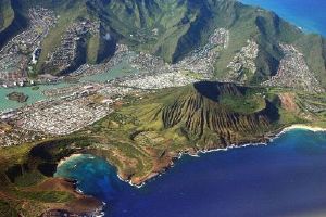
[[Image:Oahu from air2.jpg|thumb|left|Hawaii Kai from the air]] | [[Image:Oahu from air2.jpg|thumb|left|Hawaii Kai from the air]] | ||
| − | The [[United States Census, 2000|2000 census]] showed a population of 876,151, which was essentially the entire population of [[Honolulu County, Hawaii|Honolulu County]] except for 5 individuals who lived in the far-flung [[Northwestern Hawaiian Islands]] portion of the county in the [[United States Census Bureau]]'s [[census tract|Census Tract]] 114.98 of | + | The [[United States Census, 2000|2000 census]] showed a population of 876,151, which was essentially the entire population of [[Honolulu County, Hawaii|Honolulu County]] except for 5 individuals who lived in the far-flung [[Northwestern Hawaiian Islands]] portion of the county in the [[United States Census Bureau]]'s [[census tract|Census Tract]] 114.98 of Honolulu County, Hawai{{okina}}i.<ref>[http://factfinder.census.gov/servlet/DTTable?_bm=y&-show_geoid=Y&-tree_id=4001&-_caller=geoselect&-context=dt&-errMsg=&-all_geo_types=N&-mt_name=DEC_2000_SF1_U_P001&-redoLog=true&-transpose=N&-search_map_config=|b=50|l=en|t=4001|zf=0.0|ms=sel_00dec|dw=0.0434325535289488|dh=0.030379461750392432|dt=gov.census.aff.domain.map.EnglishMapExtent|if=gif|cx=-157.9258718592724|cy=21.666164504299697|zl=3|pz=3|bo=318:317:316:314:313:323:319|bl=362:393:358:357:356:355:354|ft=350:349:335:389:388:332:331|fl=381:403:204:380:369:379:368|g=05000US15003&-PANEL_ID=p_dt_geo_map&-_lang=en&-geo_id=05000US15003&-geo_id=14000US15003011498&-CONTEXT=dt&-format=&-search_results=100$10000US150030102029006&-ds_name=DEC_2000_SF1_U Honolulu County and Census Tract 114.98, Honolulu County] United States Census Bureau</ref> |
| − | The island is home to about 900,000 people (approximately 75% of the resident population of the state) and partly because of this, O{{okina}}ahu has for a long time been nicknamed "The Gathering Place" | + | The island is home to about 900,000 people (approximately 75% of the resident population of the state) and partly because of this, O{{okina}}ahu has for a long time been nicknamed "The Gathering Place." However, the term ''O{{okina}}ahu'' has no confirmed meaning in [[Hawaiian language|Hawaiian]], other than that of the place itself (Pukui, et al., 1976). Ancient Hawaiian tradition attributes the name's origin in the legend of [[Hawaiiloa|Hawai{{okina}}iloa]], the [[Polynesia]]n navigator credited with discovery of the Hawaiian Islands. The story relates that he named the island after a son. |
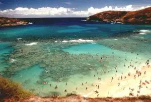
The city of [[Honolulu, Hawaii|Honolulu]]—largest city, state capital, and main deepwater marine port for the State of Hawai{{okina}}i—is located here. As a jurisdictional unit, the entire island of O{{okina}}ahu is in the [[City & County of Honolulu]], although as a place name, Honolulu occupies only a portion of the southeast end of the island (essentially, the Honolulu District). The island extends from [[Kaena Point|Ka{{okina}}ena]] on the west end to [[Makapuu|Makapu{{okina}}u]] on the east. Well-known features found on O{{okina}}ahu include [[Waikiki|Waikīkī]], [[Pearl Harbor]], [[Diamond Head (Hawaii)|Diamond Head]], [[Hanauma Bay]], [[Kaneohe Bay|Kāne{{okina}}ohe Bay]], and the [[Pupukea, Hawaii|North Shore]]. | The city of [[Honolulu, Hawaii|Honolulu]]—largest city, state capital, and main deepwater marine port for the State of Hawai{{okina}}i—is located here. As a jurisdictional unit, the entire island of O{{okina}}ahu is in the [[City & County of Honolulu]], although as a place name, Honolulu occupies only a portion of the southeast end of the island (essentially, the Honolulu District). The island extends from [[Kaena Point|Ka{{okina}}ena]] on the west end to [[Makapuu|Makapu{{okina}}u]] on the east. Well-known features found on O{{okina}}ahu include [[Waikiki|Waikīkī]], [[Pearl Harbor]], [[Diamond Head (Hawaii)|Diamond Head]], [[Hanauma Bay]], [[Kaneohe Bay|Kāne{{okina}}ohe Bay]], and the [[Pupukea, Hawaii|North Shore]]. | ||
| Line 33: | Line 33: | ||
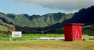
[[Image:Makua-valley.jpg|thumb|left|Mākua Valley military testing area, O{{okina}}ahu, Hawai{{okina}}i.]] | [[Image:Makua-valley.jpg|thumb|left|Mākua Valley military testing area, O{{okina}}ahu, Hawai{{okina}}i.]] | ||
| − | O{{okina}}ahu was apparently the first of the Hawaiian Islands sighted by the crew of ''HMS Resolution'' on 18 January | + | O{{okina}}ahu was apparently the first of the Hawaiian Islands sighted by the crew of ''HMS Resolution'' on 18 January 1778 during Capt. [[James Cook]]'s third Pacific expedition. Escorted by ''HMS Discovery'', the expedition was surprised to find high islands this far north in the central Pacific. O{{okina}}ahu was not actually visited by Europeans until 28 February 1779 when Captain Clerke aboard ''HMS Resolution'' stepped ashore at [[Waimea Bay, Hawaii|Waimea Bay]]. Clerke had taken command of the ship after Capt. Cook was killed at Kealakekua Bay ([[Hawaii Island|Island of Hawai{{okina}}i]]) on February 14, and was leaving the islands for the North Pacific. |
| − | The opening battle of the [[World War II|Second World War]] in the Pacific for the United States was the Imperial Japanese Navy [[attack on Pearl Harbor]], O{{okina}}ahu on the morning of | + | The opening battle of the [[World War II|Second World War]] in the Pacific for the United States was the Imperial Japanese Navy [[attack on Pearl Harbor]], O{{okina}}ahu on the morning of December 7, 1941. The surprise attack was aimed at the Pacific Fleet of the United States Navy and its defending Army Air Corps and Marine Air Forces. The attack damaged or destroyed twelve American warships, destroyed 188 aircraft, and resulted in the deaths of 2,403 American servicemen and 68 civilians. |
Today, O{{okina}}ahu has become a tourism and shopping haven as over 5 million visitors (mainly from the [[United States|American mainland]] and [[Japan]]) flock there every year to enjoy the quintessential island holiday experience that the Hawaiian Islands and her multicultural people now personify. | Today, O{{okina}}ahu has become a tourism and shopping haven as over 5 million visitors (mainly from the [[United States|American mainland]] and [[Japan]]) flock there every year to enjoy the quintessential island holiday experience that the Hawaiian Islands and her multicultural people now personify. | ||
| Line 88: | Line 88: | ||
[[Category:Islands of Hawaii|Oahu]] | [[Category:Islands of Hawaii|Oahu]] | ||
[[Category:Oahu| ]] | [[Category:Oahu| ]] | ||
| − | |||
| − | |||
| − | |||
| − | |||
| − | |||
| − | |||
| − | |||
| − | |||
| − | |||
| − | |||
| − | |||
| − | |||
| − | |||
| − | |||
| − | |||
| − | |||
| − | |||
| − | |||
| − | |||
| − | |||
| − | |||
| − | |||
| − | |||
| − | |||
| − | |||
| − | |||
| − | |||
| − | |||
{{Credit|166199042}} | {{Credit|166199042}} | ||
Revision as of 00:35, 23 October 2007
| Oʻahu The Gathering Isle | |
|---|---|
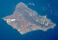 Satellite photo of Oʻahu | |
| Geography | |
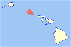 Location in the state of Hawaii | |
| Location | 21°28′N 157°59′W |
| Area | 596.7 sq mi (1545.3 km²) |
| Rank | 3rd largest Hawaiian Island |
| Highest point | Mt. Kaʻala 4,003 ft (1,220 m) |
| Demographics | |
| Population | 876,151 (as of 2000) |
| Density | 1,468/sq mi (567/km²) |
| Official Insignia[1] | |
| Flower | Ilima |
| Color | Mele Mele (Yellow) |
Oʻahu (usually Oahu outside Hawaiian and Hawaiian English), the "Gathering Place," is the third largest of the Hawaiian Islands and most populous of the islands in the State of Hawaiʻi. Including small close-in offshore islands such as Ford Island and the islands in Kaneohe Bay and off the eastern coast, it has a total land area of 1,545.3 km² (596.7 mile²).[2] In greatest dimension, this volcanic island is 71 km (44 mi) long and 48 km (30 mi) across. The length of the shoreline is 366 km (227 mi). The island is the result of two separate shield volcanoes: Waiʻanae and Koʻolau, with a broad "valley" or saddle (the central Oʻahu Plain) between them. The highest point is Mt. Kaʻala in the Waiʻanae Range, rising to 1,220 m (4,003 ft) above sea level.[3]
Introduction
The 2000 census showed a population of 876,151, which was essentially the entire population of Honolulu County except for 5 individuals who lived in the far-flung Northwestern Hawaiian Islands portion of the county in the United States Census Bureau's Census Tract 114.98 of Honolulu County, Hawaiʻi.[4]
The island is home to about 900,000 people (approximately 75% of the resident population of the state) and partly because of this, Oʻahu has for a long time been nicknamed "The Gathering Place." However, the term Oʻahu has no confirmed meaning in Hawaiian, other than that of the place itself (Pukui, et al., 1976). Ancient Hawaiian tradition attributes the name's origin in the legend of Hawaiʻiloa, the Polynesian navigator credited with discovery of the Hawaiian Islands. The story relates that he named the island after a son.
The city of Honolulu—largest city, state capital, and main deepwater marine port for the State of Hawaiʻi—is located here. As a jurisdictional unit, the entire island of Oʻahu is in the City & County of Honolulu, although as a place name, Honolulu occupies only a portion of the southeast end of the island (essentially, the Honolulu District). The island extends from Kaʻena on the west end to Makapuʻu on the east. Well-known features found on Oʻahu include Waikīkī, Pearl Harbor, Diamond Head, Hanauma Bay, Kāneʻohe Bay, and the North Shore.
History
Kamehameha III moved his capital from Lāhainā, Maui to Oʻahu in 1845. ʻIolani Palace, built later by other members of the royal family, is still standing, and is the only royal palace on American soil.
Oʻahu was apparently the first of the Hawaiian Islands sighted by the crew of HMS Resolution on 18 January 1778 during Capt. James Cook's third Pacific expedition. Escorted by HMS Discovery, the expedition was surprised to find high islands this far north in the central Pacific. Oʻahu was not actually visited by Europeans until 28 February 1779 when Captain Clerke aboard HMS Resolution stepped ashore at Waimea Bay. Clerke had taken command of the ship after Capt. Cook was killed at Kealakekua Bay (Island of Hawaiʻi) on February 14, and was leaving the islands for the North Pacific.
The opening battle of the Second World War in the Pacific for the United States was the Imperial Japanese Navy attack on Pearl Harbor, Oʻahu on the morning of December 7, 1941. The surprise attack was aimed at the Pacific Fleet of the United States Navy and its defending Army Air Corps and Marine Air Forces. The attack damaged or destroyed twelve American warships, destroyed 188 aircraft, and resulted in the deaths of 2,403 American servicemen and 68 civilians.
Today, Oʻahu has become a tourism and shopping haven as over 5 million visitors (mainly from the American mainland and Japan) flock there every year to enjoy the quintessential island holiday experience that the Hawaiian Islands and her multicultural people now personify.
A series of earthquakes struck Oʻahu and the surrounding islands on October 15, 2006, interrupting electrical supplies and knocking television broadcasting stations off the air. Preliminary reports said that the first earthquake measured 6.3 on the Richter scale and originated 155 miles southeast of Honolulu.
Tourist attractions
- Ala Moana
- Diamond Head
- Hanauma Bay
- Honolulu
- Honolulu Academy of Arts
- North Shore
- Pearl Harbor
- Polynesian Cultural Center
- USS Arizona Memorial
- USS Missouri
- Waikīkī
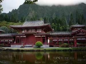
- Valley of the temples
Television and Film
Oʻahu has been featured in many movies and TV shows, including, but not limited too: 50 First Dates, Blue Crush, Flight 29 Down, Hawaii Five-O, Jake and the Fatman, the Jurassic Park movies, Lost, Magnum P.I., North Shore, and Pearl Harbor. The reality TV show Dog the Bounty Hunter is filmed in the regions of Honolulu, Oʻahu (as well as other regions in Oʻahu), and the city of Kailua-Kona on the Big Island of Hawaiʻi.
Multiplayer online racing game Test Drive Unlimited (Xbox 360 / PC / PS2 / PSP) takes place on a fully modeled Oahu island with 1,000 miles of roads and highways.
Notes
- ↑ State of Hawaiʻi: Office of the Governor. Fun Facts about Hawaiʻi Retrieved December 14, 2008.
- ↑ Table 5.08 - Land Area of Islands: 2000. 2004 State of Hawaii Data Book. State of Hawaii (2004). Retrieved 2007-07-23.
- ↑ Table 5.11 - Elevations of Major Summits. 2004 State of Hawaii Data Book. State of Hawaii (2004). Retrieved 2007-07-23.
- ↑ Honolulu County and Census Tract 114.98, Honolulu County United States Census Bureau
ReferencesISBN links support NWE through referral fees
- Macdonald, Gordon A., Agatin T. Abbott, and Frank L. Peterson. 1983. Volcanoes in the Sea. University of Hawaiʻi Press, Honolulu. 517 pp.
- Pukui, M.K., S.H. Elbert, and E.T. Mookini. 1976. Place names of Hawaiʻi. University of Hawaiʻi Press. 289 pp.
External links
- Travel guide to Oahu from Wikitravel
- Beautiful spots to visit Collected by a long time Hawaiʻi Resident
- Photos of Oʻahu - Terra Galleria
- Hawaiimode---Hawaii Travel Information
- Hawaiʻi State Vacation Planner
- Hawaiʻi Beaches Hawaiʻi beaches are shared by a lifelong Hawaiʻi resident through favorite ocean activities like fishing, diving, bodysurfing, bodyboarding, windsurfing, and kayaking.
- A history of Oahu's Harbors
| State of Hawaii Honolulu (capital) | |
| Topics | Culture |
Geography | Government | History | Music | Politics | People |
| Main Islands | Hawaii |
Kahoolawe | Kauai | Lanai | Maui | Molokai | Niihau | Oahu |
| French Frigate Shoals |
Gardner | Kure | Laysan | Lisianski | Maro Reef | Necker | Nihoa | Pearl and Hermes | |
| Communities | Hilo |
Honolulu | Kahului | Kaneohe | Waipahu | Lihue | Pearl City |
| Counties | Hawaii |
Honolulu | Kalawao | Kauai | Maui |
Credits
New World Encyclopedia writers and editors rewrote and completed the Wikipedia article in accordance with New World Encyclopedia standards. This article abides by terms of the Creative Commons CC-by-sa 3.0 License (CC-by-sa), which may be used and disseminated with proper attribution. Credit is due under the terms of this license that can reference both the New World Encyclopedia contributors and the selfless volunteer contributors of the Wikimedia Foundation. To cite this article click here for a list of acceptable citing formats.The history of earlier contributions by wikipedians is accessible to researchers here:
The history of this article since it was imported to New World Encyclopedia:
Note: Some restrictions may apply to use of individual images which are separately licensed.
