Difference between revisions of "Luang Phrabang" - New World Encyclopedia
Dan Davies (talk | contribs) |
Dan Davies (talk | contribs) |
||
| Line 72: | Line 72: | ||
<center> | <center> | ||
<gallery> | <gallery> | ||
| − | Image:Markt Luang Prabang.jpg | + | Image:Markt Luang Prabang.jpg|A street market in Luang Prabang. |
| + | Image:Haw Kham-Luang Phrabang.jpg|Royal palace museum of Luang Phrabang (Haw Kham) | ||
| + | Image:Palais-Musée.JPG|Luang Prabang: National Museum (ancient royal palace) | ||
| + | Image:Kuang Si 3.JPG| Kuang Si Falls, Luang Prabang (Laos) | ||
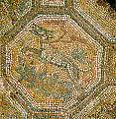
| + | Image:Mosaic detail, Wat Xieng Thong.jpg|Mosaic detail, Wat Xieng Thong, Luang Prabang | ||
| + | Image:Wat Xieng Thong 2.jpg|Wat Xieng Thong, Luang Prabang | ||
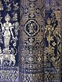
| + | Image:Mosaic.jpg|Mosaic detail from the wall of Wat Xien Thong temple, Luang Prabang, Laos. | ||
</gallery> | </gallery> | ||
</center> | </center> | ||
Revision as of 20:01, 31 August 2008
| Town of Luang Prabang* | |
|---|---|
| UNESCO World Heritage Site | |

| |
| State Party | |
| Type | Cultural |
| Criteria | ii, iv, v |
| Reference | 479 |
| Region** | Asia-Pacific |
| Inscription history | |
| Inscription | 1995 (19th Session) |
| * Name as inscribed on World Heritage List. ** Region as classified by UNESCO. | |
Luang Prabang, or Louangphrabang (Lao: ຫລວງພະບາງ, IPA: /luaŋ pʰabaːŋ/), is a city located in north central Laos, on the Mekong River about 425 kilometers north of Vientiane, and the capital of Louangphrabang Province. The current population of the city numbers about 103,000. The city had been the capital of the Luang Prabang kingdom.[1] Until the communist takeover in 1975, it served as the royal capital and seat of government of the Kingdom of Laos. UNESCO designated the Town of Luang Prabang a World Heritage Site in 1995.
History
Muang Sua had been the earlier name of Luang Prabang following its conquest in 698 C.E. by a Tai prince, Khun Lo, who seized his opportunity when Nan-chao was engaged elsewhere.[2] Khun Lo had been awarded the town by his father, Khun Borom, who is associated with the Lao legend of the creation of the world, which the Lao share with the Shan and other peoples of the region. Khun Lo established a dynasty whose fifteen rulers reigned over an independent Muang Sua for the better part of a century.
In the second half of the eighth century, Nan-chao intervened frequently in the affairs of the principalities of the middle Mekong Valley, resulting in the occupation of Muang Sua in 709. Nan-chao princes or administrators replaced the aristocracy of Tai overlords. Dates of the occupation are not known, but it probably ended well before the northward expansion of the Khmer empire under Indravarman I (r. 877-89) and extended as far as the territories of Sipsong Panna on the upper Mekong.[3]

In the meantime, the Khmers founded an outpost at Xay Fong near Vientiane, and Champa expanded again in southern Laos, maintaining its presence on the banks of the Mekong until 1070. Chanthaphanit, the local ruler of Xay Fong, moved north to Muang Sua and was accepted peacefully as ruler after the departure of the Nan-chao administrators. Chanthaphanit and his son had long reigns, during which the town became known by the Tai name Xieng Dong Xieng Thong. The dynasty eventually became involved in the squabbles of a number of principalities. Khun Chuang, a warlike ruler who may have been a Kammu (alternate spellings include Khamu and Khmu) tribesman, extended his territory as a result of the warring of these principalities and probably ruled from 1128 to 1169. Under Khun Chuang, a single family ruled over a far-flung territory and reinstituted the Siamese administrative system of the seventh century. At some point, Theravada Buddhism was subsumed by Mahayana Buddhism.[4]

Xieng Dong Xieng Thong experienced a brief period of Khmer suzerainty under Jayavarman VII from 1185 to 1191. By 1180 the Sipsong Panna had regained their independence from the Khmers, however, and in 1238 an internal uprising in the Khmer outpost of Sukhothai expelled the Khmer overlords. Xieng Dong Xieng Thong in 1353 became the capital of Lan Xang. The capital was moved in 1560 by King Setthathirath I to Vien Chang, which remains the capital today.
In 1707, Lan Xang fell apart and Luang Prabang became the capital of the independent Luang Prabang kingdom. When France annexed Laos, the French recognized Luang Prabang as the royal residence of Laos. Eventually, the ruler of Luang Prabang became synonymous with the figurehead of the French Protectorate of Laos. When Laos achieved independence, the king of Luang Prabang, Sisavang Vong, became the head of state for the Kingdom of Laos.[5]
Monarchs of Luang Prabang
- Khun Lo, warlord who founded the city
- Fa Ngum, prince of Luang Prabang who founded Lan Xang
- Oun Kham, king who ruled under the French
- Kham Souk (Zakarine), king who ruled under the French and who pushed for independence
- Sisavang Vong, king under the French, and when France granted Laos independence, he became king of the whole country
Historical and Natural Sites[6]

- Kuang Si Falls
- Phu Si
- Royal Palace Museum (Haw Kham)
- Wat Aham
- Wat Mai Suwannaphumaham
- Wat Manorom
- Wat That Luang
- Wat Wisunarat
- Wat Xieng Muan
- Wat Xieng Thong
Travel
Luang Prabang is served by Luang Prabang International Airport with non-stop flights to
- Laos: Phongsaly, Vientiane, Xieng Khuang (Phonsavan)
- Thailand: Bangkok, Chiang Mai
- Cambodia: Siem Reap
- Vietnam: Ha Noi
- Malaysia: Kuala Lumpur
Luang Prabang is linked by road to:
- Route 13: Vang Vieng and Vientiane
- Route 1: Muang Xay
Travelers from Chiang Khong can hire a barge for the Mekong River crossing. The road from Huay Xai (the Laos town across the river from Chiang Khong) to Luang Prabang is poorly maintained, remote, unlit, unmarked and extremely dangerous for the unfamiliar traveler, particularly in the wet season. Regular buses nonetheless do run, taking 14-16 hours. [7]
The road from Vientiene (the capital of Laos) to Luang Prabang is generally well paved, but remote, narrow, curvy, unmarked, and unlit. Several daily buses run from Vientiane to Luang Prabang, taking 8-10 hours [8]. Travelers from Nong Khai in Thailand can cross the Mekong River to Vientiane using the Thai–Lao Friendship Bridge. The Mekong is an important transportation link. Huay Xai, upriver near the Thai border, can be reached by slow boat in two days, typically with a stop at Pakbeng.
Current History
The late folk singer Dave Van Ronk named his infamous and sardonic anti-war song Luang Prabang, which was also featured on the infamous Patrick Sky album, Songs That Made America Famous. Matt Harding, from the Internet phenomenon "Where the Hell is Matt?," danced in Luang Prabang for his second travel video. [9] China has recently allowed its citizens to travel more freely to Laos. As such, Chinese tourists are expected to account for 25 percent of the total number of visitors to Laos (up from only a few percent) in 2006. Pressures to modernize tourist infrastructure, particularly to cater to package tourism, are expected to significantly impact Luang Prabang and other culturally significant Laotian cities and sites. [10] Kahn Souphanousinphone from the animated television show King of the Hill is from Louangphrabong.
Gallery
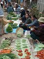
A street market in Luang Prabang.
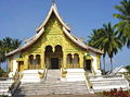
Royal palace museum of Luang Phrabang (Haw Kham)
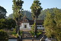
Luang Prabang: National Museum (ancient royal palace)
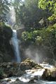
Kuang Si Falls, Luang Prabang (Laos)
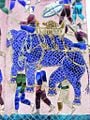
Mosaic detail, Wat Xieng Thong, Luang Prabang
Wat Xieng Thong, Luang Prabang
Mosaic detail from the wall of Wat Xien Thong temple, Luang Prabang, Laos.


See also
- Laos
- Phra Bang
- Emerald Buddha
Notes
- ↑ Keat Gin Ooi. 2004. Southeast Asia: a historical encyclopedia, from Angkor Wat to East Timor (Santa Barbara, Calif: ABC-CLIO), p. 796.
- ↑ John Stewart Bowman. 2000. Columbia chronologies of Asian history and culture (New York: Columbia University Press), p. 453
- ↑ Andrea Matles Savada. 1995. Laos: a country study. Area handbook series (Washington, DC: Federal Research Division, Library of Congress), p. 6.
- ↑ Savada. Laos", p. 7.
- ↑ Thi Dieu Nguyen. 1999. The Mekong River and the struggle for Indochina: water, war, and peace (Westport, Conn: Praeger), p. 10.
- ↑ Ismail Serageldin and Joan Martin-Brown. 1998. Partnerships for global ecosystem management science, economics and law: proceedings and reference readings (Washington, DC: World bank), p. 269.
- ↑ Luang Prabang. Retrieved August 31, 2008.
- ↑ Luang Prabang. Retrieved August 31, 2008.
- ↑ Where the hell is Matt?. Retrieved August 31, 2008.
- ↑ IOL Travel. Retrieved August 31, 2008.
ReferencesISBN links support NWE through referral fees
- Bowman, John Stewart. 2000. Columbia chronologies of Asian history and culture. New York: Columbia University Press. ISBN 9780231110051.
- Nguyen, Thi Dieu. 1999. The Mekong River and the struggle for Indochina: water, war, and peace. Westport, Conn: Praeger. ISBN 9780275961374.
- Ooi, Keat Gin. 2004. Southeast Asia: a historical encyclopedia, from Angkor Wat to East Timor. Santa Barbara, Calif: ABC-CLIO. ISBN 9781576077702.
- Savada, Andrea Matles. 1995. Laos: a country study. Area handbook series. Washington, DC: Federal Research Division, Library of Congress. ISBN 9780844408323.
- Serageldin, Ismail, and Joan Martin-Brown. 1998. Partnerships for global ecosystem management science, economics and law : proceedings and reference readings. Washington, DC: World bank. ISBN 9780821342657.
External links
- UNESCO The Town of Luang Phrang. Retrieved August 31, 2008.
- Cartes postales du Laos (french website). Retrieved August 31, 2008.
- Where to visit: Luang Phrabang. Retrieved August 31, 2008.
- Luang Prabang Province. Retrieved August 31, 2008.
- Pictures of Luang Phrabang, Laos: Monks, Wats, and a boat tour on the Mekong River.. Retrieved August 31, 2008.
- Violence against Christians in Vientiane and Luang Phrabang. Retrieved August 31, 2008.
Credits
New World Encyclopedia writers and editors rewrote and completed the Wikipedia article in accordance with New World Encyclopedia standards. This article abides by terms of the Creative Commons CC-by-sa 3.0 License (CC-by-sa), which may be used and disseminated with proper attribution. Credit is due under the terms of this license that can reference both the New World Encyclopedia contributors and the selfless volunteer contributors of the Wikimedia Foundation. To cite this article click here for a list of acceptable citing formats.The history of earlier contributions by wikipedians is accessible to researchers here:
The history of this article since it was imported to New World Encyclopedia:
Note: Some restrictions may apply to use of individual images which are separately licensed.