Golden Mountains of Altai
| Golden Mountains of Altai* | |
|---|---|
| UNESCO World Heritage Site | |

| |
| State Party | |
| Type | Natural |
| Criteria | x |
| Reference | 768 |
| Region** | Europe |
| Inscription history | |
| Inscription | 1998 (22nd Session) |
| * Name as inscribed on World Heritage List. ** Region as classified by UNESCO. | |
The Altai Mountains are a mountain system or of Central Asia that extends approximately 1,200 miles (2,000 km) in a southeast-northwest direction from the Gobi Desert to the West Siberian Plain, through Chinese, Mongolian, Russian, and Kazak territory, where Russia, China, Mongolia and Kazakhstan come together, and where the great rivers Irtysh, Ob and Yenisei have their sources.
A vast area of Altai - 6245.2 square miles (16,175 km²) - has been protected as a UNESCO World Heritage Site. The Site area includes the Altai and Katun Natural Reserves, Lake Teletskoye, Mount Belukha and the Ukok Plateau. As stated in the UNESCO description of the site, "the region represents the most complete sequence of altitudinal vegetation zones in central Siberia, from steppe, forest-steppe, mixed forest, subalpine vegetation to alpine vegetation."
While making its decision, UNESCO also cited Russian Altai's importance for preservation of globally endangered mammals, such as the snow leopard and the Altai argali, the world's largest breed of wild sheep. [1]
Altai State Nature Reserve
The Altai State Nature Reserve was established in 1932. It is situated in South-Eastern part of Gorny Altai in the upper reaches and right bank of the Tchulyshman River and the Teletskoye Lake on the territory of Ulagansky and Turochaksky Regions. The Reserve covers an area of 863861 hectares. The Reserve has a stretched form and is 250 km long in meridional direction having an average width of about 35 km. The Reserve was founded to protect the nature of taiga and highland tundra. The absolute altitudes of the Reserve, which are situated on Tchulyshman Plateau are 2500-3000 m high. Main rocks are granites, granite and gneiss, mica shale. The Reserve's location close to the center of Asia conditions the general temperate-continental climate. However, peculiarities of relief and conditions of air masses transfer, taking into consideration a large area of the Reserve, raise a great variety of climatic conditions. Its northern part is distinguished by warm and moist summers, snowy and comparatively mild winters. An average annual temperature is 3.2°; an average January temperature is -8.77°; of July +16.0°С. About 850-1100 mm of precipitation fall a year, about a half of them fall in summer.
The territory near the Teletskoye Lake is characterized by a considerable thickness of snow cover - up to 80-120 cm. In the whole, the northern part of the Reserve bordering on Lake Teletskoye is one of the warmest and moistest places of Gorny Altai. Climate of south-western part of the Reserve is sharply continental and very severe. In winters the frosts are up to -50°C, and in summer days the maximum temperature reaches +30°C. Average annual temperature is -5°C. The level of precipitation is 3-4 times lower, than that near the Teletskoye Lake, and the length of vegetation period is only a month and a half compared to five months in the northern part. In the Altai Preserve there are 1190 lakes having an area of over 0.01 square km each. The main part of them is situated in the upper lands. The origin of lake hollows is connected with glaciers' activity. The depth of the lakes is considerable - up to 35-50 m. The biggest lake among the highland lakes of the Reserve - "Julukul" - is situated in the hollow with the same name at the altitude of 2200 m. The area of Lake Julukul is 30 square km, the depth - 7-9 m, the length - 10 km. The largest river of the Reserve - the Tchulyshman - flows out of this lake and stretches for 210 km. The main reservoir of the Reserve - the Teletskoye Lake, the largest and the most beautiful lake of Altai - is situated at the height of 434 m above sea-level. The lake stretches for 78 km as a narrow blue ribbon squeezed by the ridges Korbu and Al-tyntu. Its width is 5 km and the area is not too big - 233 square km, however due to its depth (up to 325 m) it contains a great amount (40 bln. square km) of the purest fresh water saturated with oxygen. Giving its waters to the Biya River, the Lake provides the Ob's supply to a considerable extent. About 70 rivers and 150 temporary streams flow into the Lake, and more than a half of the whole water is supplied by the Tchulyshman River. A great number of enthusiastic descriptions and legends is devoted to the Teletskoye Lake (Altyn-Kyol) - the Altaians' "Golden Lake". The Teletskoye Lake is a beautiful natural memorial of Siberia surrounded by mountains and dark-coniferous - mostly cedar - taiga. The Reserve's landscapes are presented by four vertical zones - steppe, forest, sub-Alpine and Alpine ones. In the whole the Reserve's flora contains 1270 plant species, 73 mammal species, about 300 bird species, 10 species of Amphibias and reptiles. Among animals the most characteristic ones are - maral, elk, brown bear, musk-deer, sable, glutton, lynx, roe, squirrel, chipmunk, snow leopard. Among birds - wood-grouse, hazel-grouse, eagle-owl, willow grouse and ptarmigan, redstart and others. There are 13 fish species in Lake Teletskoye. Grayling is found in majority of the rivers. The main direction of scientific researches conducted in the Reserve is studying of mountain taiga's flora and fauna, highland tundra, Alpine high-altitude zone. [2]
Katun State Nature Preserve
Lake Teletskoye

Lake Teletskoye, literally "Golden Lake", is the largest lake in the Altai Mountains and within the Altai Republic. It is one of 25 deepest lakes in the world, having a depth of up to 1066 feet (325 meters). [2]
Situated at a height of 1,424 feet (434 m) above sea level, the lake is 48 miles (78 km) long and three miles (five km) wide and lies between the mountain ridges Korbu and Al-tyntu, on the junction of Sailughem Mountains and Western Sayans. Its surface area is 90 square miles (233 sq km); however, due to its considerable depth (1,066 ft - 325 m), the lake contains no less than 15 square miles (40 sq km) of fresh water. Annual water level fluctuations are estimated at some 348 sm. The lake transparency is high, with the visibility of the lake water ranging from six to fourteen meters.
About 70 rivers and 150 temporary streams flow into the lake, the largest of them, Chulyshman River, supplying more than half of the lake's water. The lake is drained through a single outlet, the Biya River, which, after its confluence with the Katun River, forms one of Siberia's largest rivers, the Ob River.
The lake is surrounded by mountains of 1968 - 4265 feet (600-1,300 m) in the northern section and about 5,578 - 7,874 feet (1,700-2,400 m) in the southern part. Lake Teletskoe is included in the Altai State Nature Reserve.
Mount Belukha
Belukha Mountain (Russian: Белуха; Altai: Muztau), located in the Katun Mountains, is the highest peak of the Altai Mountains in Russia. [3]
Belukha is a twin-peaked mountain massif that rises along the border of Russia and Kazakhstan, just north of the point where these two borders meet those of China and Mongolia. There are several small glaciers on the mountain. Of the two peaks, the eastern peak (4,506 m, 14,784 ft.) is higher than the western peak (4,440 m, 14,567 ft.). Some 27 square miles (70 square km) of Belukha's surface is glacier-covered. The mountain lies in a region of year-round snows.
Belukha was first climbed in 1914 by the Tronov brothers. Most ascents of the eastern peak follow the same southern route as that taken in the first ascent. Though the Altai is lower in elevation than other Asian mountain groups, it is very remote, and much time and planning are required for its approach.
Ukok Plateau

Ukok Plateau is a remote and pristine grasslands area located in the heart of southwestern Siberia, the Altai Mountains region of Russia near the borders with China, Kazakhstan and Mongolia. The Pazyryk is the name of an ancient people who lived in the Altai Mountains on this plateau, and who are associated with some spectacular archeological findings, including mummies found frozen in the permafrost. Many ancient Bronze Age tomb mounds have been found in the area and have been associated with the Pazyryk culture which closely resembled that of the legendary Scythian people to the west. [4] The term kurgan is in general usage to describe such log-barrow burials. Excavations of this site have continued to yield fascinating archaeological findings. [5]
One of the most well-known of the discoveries in the Ukok Plateau region is the "Ice Princess" excavated by Russian archaeologist, Natalia Polosmak. [6] Three tattooed mummies (c. 300 B.C.E.) were extracted from the permafrost of the Ukok Plateau in the second half of the 20th century. [7] The Ice Maiden and other archaeological finds were located within a disputed strip of land between Russia and China. The Ice Princess is now being stored in Novosibirsk (Russia's third largest city). The indigenous population of Altai have demanded a return of these artifacts to the Ukok, and decrying the "desecration of the Altain sacred place". [8]

Ukok Plateau Artifacts
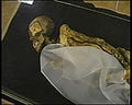
Ice Princess mummy

Horseman, Pazyryk felt artifact, c.300 B.C.E.
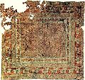
Pazyryk carpet, 5th century B.C.E.


Concerns
The Ukok Plateau is recognized as an important environmental treasure which provides a habitat for many of the world's endangered species including one of its least studied predatory animals: the snow leopard. Other endangered species protected there include the Argali mountain sheep, the steppe eagle, and the Black Stork. [9]
The snow leopard is considered an "indicator species" by scientists, meaning one by which the health of an entire environment can be determined. Because these animals are hunted for their bones and fur, as well as forced from their habitat by human population growth, they are considered endangered throughout their entire range in the high mountains of Central Eurasia. Approxmiately five percent of the leopard's range is protected. [9]

Notes
- ↑ Pacific Environment. Greater Altai – Altai Krai, Republic of Altai, Tyva (Tuva), and Novosibirsk Retrieved July 21, 2008.
- ↑ 2.0 2.1 Altai Republic. Altai Reserve Retrieved July 21, 2008.
- ↑ Encyclopedia Britannica Online. 2008. Mount Belukha Retrieved July 21, 2008.
- ↑ Paul G. Bahn. 2000. The Atlas of World Geology. New York. Checkmark Books. ISBN 0816040516
- ↑ UNESCO World Heritage Centre. Golden Mountains of Altai Retrieved July 21, 2008.
- ↑ PBS - NOVA. Ice Mummies: Siberian Ice Maiden Retrieved July 21, 2008.
- ↑ Novosibirsk State University. Collections Retrieved July 21, 2008.
- ↑ Pravda. February 21, 2005. Minor nationality of Russia demands the return of "Princess of Ukok" Retrieved July 21, 2008.
- ↑ 9.0 9.1 Forests.org. May 4, 2000. Protect Snow Leopard Habitat / Siberia Retrieved July 21, 2008.
ReferencesISBN links support NWE through referral fees
- Altai Republic. Altai Reserve Retrieved July 21, 2008.
- Earth Island Institute. Golden Mountains, Altai Republic, Russia Retrieved July 21, 2008.
- Pacific Environment. Greater Altai – Altai Krai, Republic of Altai, Tyva (Tuva), and Novosibirsk Retrieved July 21, 2008.
- Rudenko, S.I. Kul'tura naseleniia Gornogo Altaia v skifskoe vremia. 1970. ("The Population of the High Altai in Scythian Times")(Moscow and Leningrad, 1953) translated as Frozen Tombs of Siberia: The Pazyryk Burials of Iron Age Horsemen, M.W. Thompson, tr. (University of California Press, Berkeley) ISBN 0520013956
External links
All Links Retrieved July 21, 2008.
- Gas pipeline route in south Siberia to be approved in August (2006)
- A collection at Novosibirsk State University site, including Pazyryk
- Location map
- Golden Mountains of Altai Natural Heritage Protection Fund
Credits
New World Encyclopedia writers and editors rewrote and completed the Wikipedia article in accordance with New World Encyclopedia standards. This article abides by terms of the Creative Commons CC-by-sa 3.0 License (CC-by-sa), which may be used and disseminated with proper attribution. Credit is due under the terms of this license that can reference both the New World Encyclopedia contributors and the selfless volunteer contributors of the Wikimedia Foundation. To cite this article click here for a list of acceptable citing formats.The history of earlier contributions by wikipedians is accessible to researchers here:
- Golden_Mountains_of_Altai history
- Lake_Teletskoye history
- Belukha_Mountain history
- Ukok_Plateau history
The history of this article since it was imported to New World Encyclopedia:
Note: Some restrictions may apply to use of individual images which are separately licensed.