Difference between revisions of "Derbent" - New World Encyclopedia
Mike Butler (talk | contribs) |
Mike Butler (talk | contribs) |
||
| Line 56: | Line 56: | ||
==Government== | ==Government== | ||
| + | In 2007, the Republic of Dagestan was one of the 21 republics of the Russian Federation. Dagestan's highest executive authority lies with the State Council, comprising representatives of 14 ethnicities. The members of the State Council are appointed by the Constitutional Assembly of Dagestan for a term of four years. The chairman of the State Council was the highest executive post in the republic. The People's Assembly consists of 121 deputies elected for a four-year term. | ||
| + | |||
| + | Dagestan has 41 districts, 10 cities and towns, 19 urban settlements, 694 selsoviets (administrative unit), 1605 rural localities, and 46 uninhabited rural localities. | ||
==Economy== | ==Economy== | ||
Revision as of 08:24, 13 September 2008
| Citadel, Ancient City and Fortress Buildings of Derbent* | |
|---|---|
| UNESCO World Heritage Site | |

| |
| State Party | |
| Type | Cultural |
| Criteria | iii, iv |
| Reference | 1070 |
| Region** | Europe and North America |
| Inscription history | |
| Inscription | 2003 (27th Session) |
| * Name as inscribed on World Heritage List. ** Region as classified by UNESCO. | |
Derbent (Russian: Дербе́нт; Azeri: Dərbənd; Lezgian: Дербент; Avar: Дербенд; Persian: دربند, Darband is a city in the Republic of Dagestan, Russia. It is the southernmost city in Russia, and it is the second most important city of Dagestan.
Often identified with the legendary Gates of Alexander, Derbent claims to be the oldest city in the Russian Federation. Since antiquity the value of the area as the gate to the Caucasus has been understood and Derbent has archaeological structures over 5000 years old. As a result of this geographic particularity the city developed between two walls, stretching from the mountains to the sea. These fortifications were continuously employed for a millennium and a half, longer than any other extant fortress in the world. Over the years different nations gave the city different names, but all connected to the word 'gate'.
Geography
The name Derbent derives from the Persian darband, meaning closed gate. It was known to the Arabs as Bāb al Abwab, or Gate of Gates, and to the Turks as Demirkapı, or Iron Gate.
The modern city is built near the western shores of the Caspian Sea, south of the Rubas River, on the slopes of the Tabasaran mountains (part of the Bigger Caucasus range).
To the north of the town is the monument of the Kirk-lar, or forty heroes, who fell defending Dagestan against the Arabs in 728. To the south lies the seaward extremity of the Caucasian wall (fifty metres long), otherwise known as Alexander's Wall, blocking the narrow pass of the Iron Gate or Caspian Gates (Portae Athanae or Portae Caspiae). This, when entire, had a height of 29 ft (9 m) and a thickness of about 10 ft (3 m), and with its iron gates and numerous watch-towers formed a valuable defence of the Persian frontier.
Elevation
The city is hot and dry in the summer but the winters are hard in the mountain areas. The average maximum daytime temperature in January 35.6°F (2°C) and around 86°F (30°C) in July. Average annual precipitation is ... inches (200mm).
Rivers and canals Size – land area, size comparison Environmental issues Districts
History


Derbent has an important strategic location in the Caucasus: the city is situated on a narrow, 3-kilometre strip of land between the Caspian Sea and the Caucasus mountains. Historically, this position allowed the rulers of Derbent to control land traffic between the Eurasian Steppe and the Middle East. The only other practicable crossing of the Caucasus ridge was over the Darial Gorge.
The first intensive settlement in the Derbent area dates from the 8th century B.C.E.; the site was intermittently controlled by the Persian monarchs, starting from the 6th century B.C.E. Until the 4th century CE it was part of Caucasian Albania, and is traditionally identified with Albana, the capital. The modern name is a Persian word (دربند Darband) meaning "closed gates", which came into use in the end of the 5th or the beginning of the 6th century AD, when the city was refounded by Kavadh I of the Sassanid dynasty of Persia.
The twenty-metre-high walls with thirty north-looking towers are believed to belong to the time of Kavadh's son, Khosrau I of Persia. The Armenian chronicler Movses Kagankatvatsi wrote about "the wondrous walls, for whose construction the Persian kings exhausted our country, recruiting architects and collecting building materials with a view of constructing a great edifice stretching between the Caucasus Mountains and the Great Eastern Sea". Derbent became a strong military outpost and harbour of the Sassanid empire. During the 5th and 6th centuries Derbent becomes also an important centre for spreading the Christian faith in the Caucasus.
Movses Kagankatvatsi left a graphic description of the sack of Derbent by the hordes of Tong Yabghu of the Western Turkic Khaganate in 627. His successor, Buri-sad, proved unable to consolidate Tong Yabghu's conquests, and the city was retaken by the Persians. In 654 Derbent was captured by the Arabs, who transformed it in an important administrative centre and introduced Islam to the area. Because of its strategic position on the northern branch of the Silk Route, the fortress was contested by the Khazars in the course of the Khazar-Arab Wars.
The recent excavations on the eastern side of the Caspian Sea opposite to Derbent, have revealed the eastern counterpart to the wall and fortifications of the city in the Great Wall of Gorgan. Similar Sasanian defensive fortifications—massive forts, garrison towns, long walls—are seen on the eastern shores of the Caspian extending literally into the sea as they are witness emerging from the rising waters of the Caspian in the west at Derbent.
The Caliph Harun al-Rashid spent time living in Derbent, and brought it into great repute as a seat of the arts and commerce. According to Arab historians, Derbent, with population exceeding 50,000, was the largest city of the 9th-century Caucasus. In the 10th century, with the collapse of the Arab Caliphate, Derbent became the capital of an emirate. This emirate often fought losing wars with the neighboring Christian state of Sarir, allowing Sarir to occasionally manipulate Derbent politics. Despite that, the emirate outlived its rival and continued to flourish at the time of the Mongol invasion in 1239.
In the 14th century Derbent was occupied by Tamerlane's armies. In 1437 it fell under the control of the Shirvanshahs of Persia. During the 16th century Derbent was the arena for wars between Turkey and Persia ruled by the Persian Safavid dynasty. By the early 17th century the Safavid Shah Abbas I inflicted a serious defeat on the Turks and recovered Derbent, which had been a part of Persia for centuries previous.
By the 1735 Ganja treaty Derbent fell within the Persian state. In 1722 during the Russo-Persian War, Peter the Great of Russia wrested the town from the Persians, but in 1736 the supremacy of Nadir Shah was again recognized. In 1747 Derbent became the capital of the khanate of the same name. During the Persian Expedition of 1796 it was stormed by Russian forces under Valerian Zubov. As a consequence of the Treaty of Gulistan of 1813—between Russian and Persia—Derbent became part of the Russian Empire.

A large portion of the walls and several watchtowers have been preserved in reasonable shape till our days. The walls, reaching to the sea, date from the 6th century, Sassanid dynasty period. The city has a well preserved citadel (Narin-kala), comprising an area of 45,000 m², enclosed by strong walls. Historical attractions include the baths, the cisterns, the old cemeteries, the caravanserai, the 18th century Khan's mausoleum, as well as several mosques. The oldest mosque is the Juma Mosque, built over a 6th century Christian basilica; it has a 15th century madrassa. Other shrines include the 17th century Kyrhlyar mosque, the Bala mosque and the 18th century Chertebe mosque.
Government
In 2007, the Republic of Dagestan was one of the 21 republics of the Russian Federation. Dagestan's highest executive authority lies with the State Council, comprising representatives of 14 ethnicities. The members of the State Council are appointed by the Constitutional Assembly of Dagestan for a term of four years. The chairman of the State Council was the highest executive post in the republic. The People's Assembly consists of 121 deputies elected for a four-year term.
Dagestan has 41 districts, 10 cities and towns, 19 urban settlements, 694 selsoviets (administrative unit), 1605 rural localities, and 46 uninhabited rural localities.
Economy
Overview – Any specialization: For instance, is a manufactured product is associated with particular cities a. Milwaukee—cheese and beer b. Los Angeles—entertainment industry c. Sheffield—coal d. top 20 cities in the U.S. are highly specialized
Per capita GDP, rank Financial and business services sector Tourism Manufacturing The city is home to machine building, food, textile, fishing and fishery supplies, construction materials and wood industries. It is the production centre of Russian brandy.
Derbent is well served by transportation, with its own harbour, a railway going south to Baku, and the Baku to Rostov-on-Don road.
Demographics
Population: 101,031 (2002 Census); 78,371 (1989 Census). The Azeris are the main ethnic group, followed by Lezgins and Tabasarans.
Language Religion Colleges and universities The education infrastructure is quite good; there is a university as well as several technical schools.
Of interest
On the cultural front, there is a Lezgin drama theatre (S. Stalsky theatre). About two kilometres from the city is the vacation colony of Chayka (Seagull).
Derbent being in practice a huge museum and with magnificent mountains and shore nearby, a great potential for development of the tourism industry exists, further increased by UNESCO's classification of the Citadel, Ancient City and Fortress as a World Heritage Site in 2003; however, instability in the region has not allowed further development.
- Coat of Arms of Derbent (Dagestan) (1843).png
Coat of arms of Derbent (1843).
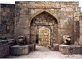
A gate in the old city of Derbent.
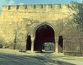
A gate of the citadel.
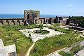
View on the Caspian Sea.


Notes
Further reading
- This article incorporates text from the Encyclopædia Britannica Eleventh Edition, a publication now in the public domain.
- Some text used with permission from www.travel-images.com.
- Avtorkhanov, Abdurakhman, and Marie Broxup. 1992. The North Caucasus Barrier: The Russian Advance Towards the Muslim World. New York: St. Martin's Press. ISBN 9780312075750.
- Beliaev, Edward, and Oksana Buranbaeva. 2006. Dagestan. New York: Marshall Cavendish Benchmark. ISBN 9780761420156.
- Blandy, Charles. 2006. Dagestan: Birth of Presidential Republic. Camberley, Surrey: Defence Academy of the United Kingdom, Conflict Studies Research Centre. ISBN 9781905058709.
- Kazem-Bek, Aleksandr. 1851. Derbend-Nâmeh, or, The history of Derbend. St. Petersburg: Printed for the Imperial Academy of Sciences. OCLC 58665611
External links
- Derbent Retrieved September 13, 2008.
- Encyclopaedia Britannica Derbent Retrieved September 13, 2008.
- A to Z of Azerbaijan Retrieved September 13, 2008.
- Photographs
- Photographs
- History and attractions of Derbent
Credits
New World Encyclopedia writers and editors rewrote and completed the Wikipedia article in accordance with New World Encyclopedia standards. This article abides by terms of the Creative Commons CC-by-sa 3.0 License (CC-by-sa), which may be used and disseminated with proper attribution. Credit is due under the terms of this license that can reference both the New World Encyclopedia contributors and the selfless volunteer contributors of the Wikimedia Foundation. To cite this article click here for a list of acceptable citing formats.The history of earlier contributions by wikipedians is accessible to researchers here:
The history of this article since it was imported to New World Encyclopedia:
Note: Some restrictions may apply to use of individual images which are separately licensed.