Encyclopedia, Difference between revisions of "David Thompson" - New World
(images ok, added flag icons, epname) |
|||
| Line 1: | Line 1: | ||
| − | {{Contracted}}{{Claimed}}{{Submitted}} | + | {{Images OK}}{{Contracted}}{{Claimed}}{{Submitted}} |
| − | + | {{epname}} | |
{{Infobox Person | {{Infobox Person | ||
| name = David Thompson | | name = David Thompson | ||
| Line 7: | Line 7: | ||
| caption = An artist's rendering of David Thompson. No historic image of Thompson exists. | | caption = An artist's rendering of David Thompson. No historic image of Thompson exists. | ||
| birth_date = {{birth date|1770|4|30,|mf=y}} | | birth_date = {{birth date|1770|4|30,|mf=y}} | ||
| − | | birth_place = [[Westminister]], [[London]], [[England]] | + | | birth_place = {{flagicon|United Kingdom}} [[Westminister]], [[London]], [[England]] |
| death_date = {{death date|1857|2|10,|mf=y}} (aged 86) | | death_date = {{death date|1857|2|10,|mf=y}} (aged 86) | ||
| − | | death_place = [[Longueuil]], [[Canada East]] | + | | death_place = {{flagicon|Canada}} [[Longueuil]], [[Canada East]] |
| occupation = [[Explorer]] and [[Cartography|Map Maker]] | | occupation = [[Explorer]] and [[Cartography|Map Maker]] | ||
| spouse = [[Charlotte Small]] | | spouse = [[Charlotte Small]] | ||
| Line 110: | Line 110: | ||
{{DEFAULTSORT:Thompson, David}} | {{DEFAULTSORT:Thompson, David}} | ||
| − | [[Category:History]] | + | [[Category:History of the Americas]] |
| + | [[category:geography]] | ||
| + | [[category:explorers]] | ||
{{credits|David_Thompson_(explorer)|174589107}} | {{credits|David_Thompson_(explorer)|174589107}} | ||
Revision as of 20:09, 22 December 2007
| David Thompson | |
.jpg) An artist's rendering of David Thompson. No historic image of Thompson exists.
| |
| Born | April 30, 1770 |
|---|---|
| Died | February 10, 1857 (aged 86) |
| Occupation | Explorer and Map Maker |
| Spouse(s) | Charlotte Small |
| Children | Fanny (1801), Samuel (1804), Emma (1806), John (1808), Joshuah (1811), Henry (1813), Charlotte (1815), Elizabeth (1817), William (1819), Thomas (1822), George (1824), Mary (1827), Eliza (1829) |
| Parents | David and Ann Thompson |
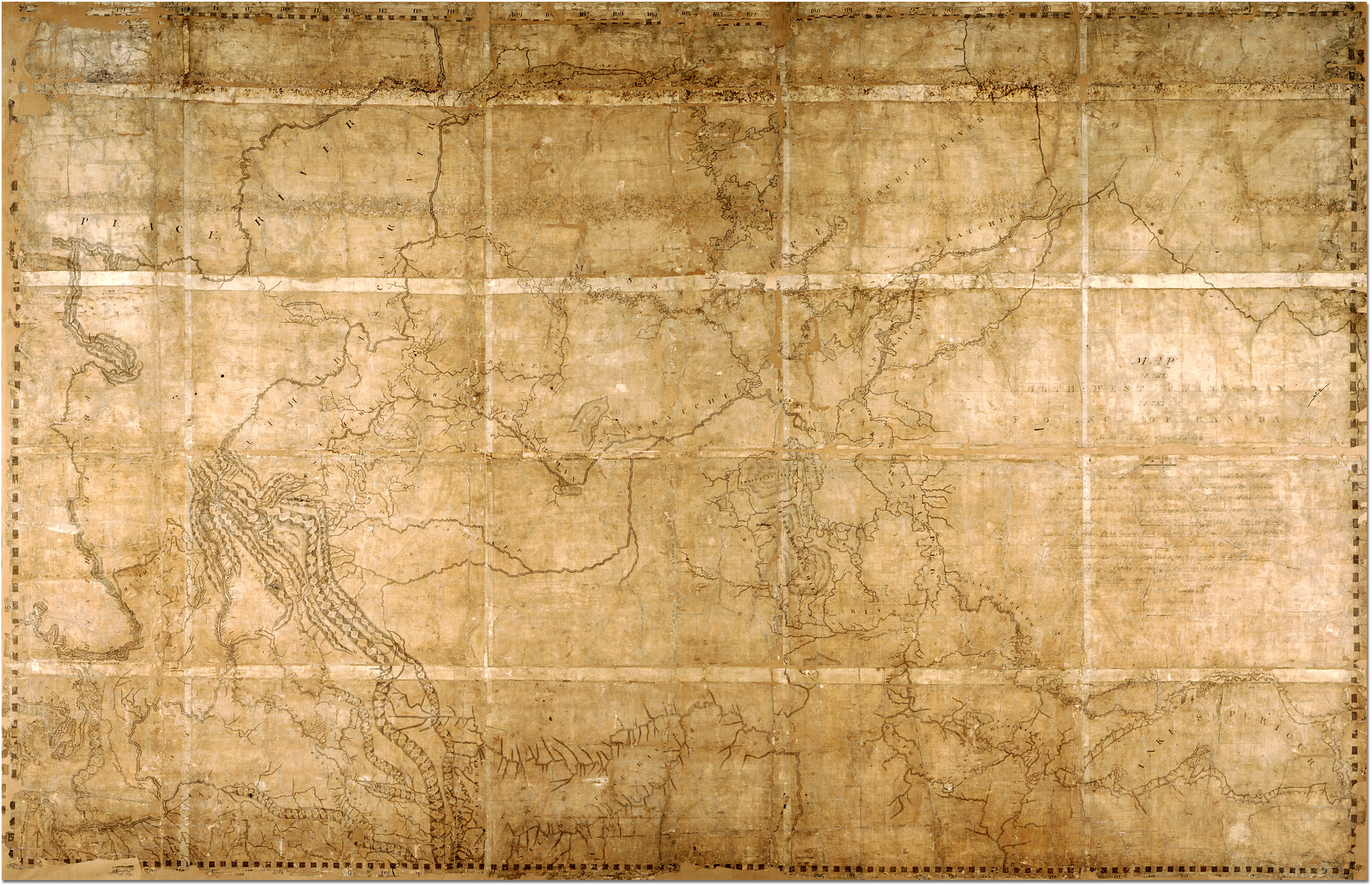
David Thompson (April 30, 1770 – February 10, 1857), was an English-Canadian fur trader, surveyor, and map-maker, known to some native peoples as "Koo-Koo-Sint" or "the Stargazer." Over his career he mapped over 3.9 million square kilometres of North America and for this has been described as the "greatest land geographer who ever lived."[1] This represented one-fifth of the North American continent. His great map, a summary of his lifetime of exploring and surveying the interior of North America. Thompson's 1814 map, his greatest achievement, was so accurate that 100 years later it was still the basis for many of the maps issued by the Canadian government. It now resides in the Archives of Ontario. The map covered the wide area stretching from Lake Superior to the Pacific Ocean, and was given by Thompson to the North West Company. His exploration and map aided in the settlement of portions of this vast region.
Biography
Early life
Thompson was born in London to recent Welsh migrants, David and Ann Thompson. When Thompson was two, his father died and the financial hardship of this occurrence resulted in his and his brother's placement in the Grey Coat Hospital, a school for the disadvantaged of Westminster. He eventually graduated to the Grey Coat mathematical school and was introduced to basic navigation skills which would form the basis of his future career. In 1784, at the age of fourteen, he entered a seven-year apprenticeship with the Hudson's Bay Company. He set sail on May 28th of that year, and left England forever.[2]
The Hudson's Bay Company
He arrived in Churchill (now in Manitoba) and was put to work copying the personal papers of the governor of Fort Churchill, Samuel Hearne. The next year he was transferred to nearby York Factory, and over the next few years spent time as a clerk at Cumberland House and South Branch House before arriving at Manchester House in 1787. On December 23, 1788, Thompson seriously fractured his leg, forcing him to spend the next two winters at Cumberland House convalescing. It was during this time he greatly refined and expanded his mathematical, astronomical and surveying skills under the tutelage of Hudson's Bay Company surveyor Philip Turnor.
In 1790 with his apprenticeship nearing its end, Thompson made the unusual request of a set of surveying tools in place of the typical parting gift of fine clothes offered by the company to those completing their indenture. He entered the employ of the Hudson's Bay Company as a fur trader and in 1792 completed his first significant survey, mapping a route to Lake Athabaska (presently straddling the Alberta/Saskatchewan border). In recognition of his map-making skills, the company promoted him to surveyor in 1794. Thompson continued working for the Hudson's Bay Company until May 23, 1797 when he left and entered the employ of the competition, the North West Company where he continued to work as a fur trader and surveyor.
North West Company
Thompson's decision to defect to the North West Company in 1797 without providing the customary one-year notice was not well received by his former employers. However, joining the North West Company allowed Thompson to pursue his interest in surveying and work on mapping the interior of what was to become Canada. In 1798, the company sent him to Red Deer Lake (in present-day Alberta) to establish a trading post. Thompson spent the next few seasons trading based in Fort George (now in Alberta), and during this time led several expeditions into the Rocky Mountains. In 1797, Thompson was sent south by his employers to survey of much of the Canada-U.S. boundary along the 49th parallel in the west, and from the St. Lawrence River to Lake of the Woods to satisfy unresolved questions of territory arising from the Jay Treaty between Great Britain and the United States. By 1798 Thompson had completed a survey of 6750 km (4,200 mi) from Grand Portage, through Lake Winnipeg, to the headwaters of the Assiniboine and Missouri Rivers, as well as two sides of Lake Superior.[2]
In 1804, at the annual meeting of the North West Company in Kaministiquia, Thompson was made a full partner of the company and spent the next few seasons based here managing the fur trading operations but still finding time to expand his surveys of the waterways around Lake Superior. However, a decision was made at the 1806 company meeting to send Thompson back out into the interior. Concern over the American-backed expedition of Lewis and Clark prompted the North West Company to charge Thompson with the task of finding a route to the Pacific in order to open up the lucrative trading territories of the Pacific Northwest.
Columbia Travels
After the general meeting in 1806, Thompson travelled to Rocky Mountain House and prepared for an expedition to follow the Columbia River to the Pacific. In June 1807 Thompson crossed the Rocky Mountains and spend the summer surveying the Columbia basin. He helped establish Kootenae House and later Saleesh House thereby successfully extending North West Company fur trading territories. Over the next few seasons, Thompson continued to survey the area. Thompson mapped and established trading posts in Northwestern Montana, Idaho, Washington, and Western Canada; including Saleesh House, the first trading post west of the Rockies in Montana. The maps he made of the Columbia River basin east of the Cascade Mountains were of such high quality and detail that they continued to be regarded as authoritative well into the mid-20th century. in fact, Thompson’s drawings of the upper portion of the Missouri River were incorporated into a map for the Lewis and Clark expedition that followed seven years later. In early 1810, was Thompson returning eastward towards Montreal but while on route at Rainy Lake, received orders to return to the Rocky Mountains and establish a route to the mouth of the Columbia. This was a response by the North West Company to the plans of John Jacob Astor to send a ship around the Americas to establish a fur trading post. During his return, Thompson was delayed by an angry group of Peigan natives which ultimately forced him to seek a new route across the Rocky Mountains through the Athabasca Pass. On July 11, 1811, Thompson made it to the newly built Fort Astoria, arriving two months after the Pacific Fur Company's ship. Thompson wintered at Saleesh House before beginning his final journey back to Montreal in 1812.
In his published journals, Thompson recorded seeing large footprints near what is now Jasper, Alberta, in 1811. It has been suggested that these prints were similar to what has since been called the sasquatch. However, Thompson noted that these tracks showed "a small Nail at the end of each [toe]," and stated that these tracks "very much resembles a large Bear's Track".[3]
Marriage and children
He married Charlotte Small on June 10 1799 at Île-à-la-Crosse, a mixed-blood child of a Scottish fur trader and a Cree mother. Their marriage was formalized at the Scotch Presbyterian Church in Montreal on October 30 1812. He and Charlotte had thirteen children together; five of them were born before he left the fur trade. The family did not adjust easily to life in Eastern Canada and two of the children, John (aged 5) and Emma (aged 7) died of round worms, a common parasite.[2] Their marriage lasted 58 years, the longest Canadian pre-Confederation marriage known.[2]

Later Years
Upon his arrival back in Montreal, Thompson retired with a generous pension from the North West Company. He settled in nearby Terrebonne and worked on completing his great map, a summary of his lifetime of exploring and surveying the interior of North America. The map covered the wide area stretching from Lake Superior to the Pacific, and was given by Thompson to the North West Company. Thompson's 1814 map, his greatest achievement, was so accurate that 100 years later it was still the basis for many of the maps issued by the Canadian government. It now resides in the Archives of Ontario.[4]
In 1815, Thompson moved his family to Williamstown, Upper Canada and a few year later was employed to survey the newly established borders with the United States from Lake of the Woods to the Eastern Townships of Quebec, established by Treaty of Ghent after the War of 1812. In 1843 Thompson completed his atlas of the region from Hudson Bay to the Pacific Ocean.
Afterwards, Thompson returned to a life as a land owner, but soon financial misfortune would ruin him. By 1831 he was so deeply in debt he was forced to take up a position as a surveyor for the British American Land Company to provide for his family. His luck continued to worsen and he was forced to move in with this daughter and son-in-law in 1845. He began work on a manuscript chronicling his life exploring the continent, but this project was left unfinished when his sight failed him in 1851.
Legacy
The land mass mapped by Thompson amounted to 3.9 million square kilometres of wilderness (one-fifth of the continent). His contemporary, the great explorer Alexander Mackenzie, remarked that Thompson did more in ten months than he would have thought possible in two years.
Despite these significant achievements, Thompson died in Montreal in near obscurity on February 10, 1857, his accomplishments almost unrecognized. He never finished the book of his 28 years in the fur trade, based on his 77 field notebooks, before he died. In the 1890s geologist J.B. Tyrrell resurrected Thompson's notes and in 1916 published them as David Thompson's Narrative.[5]
Thompson's body was interred in Montreal's Mount Royal Cemetery in an unmarked grave. It was not until 1926 that efforts by J.B. Tyrell and the Canadian Historical Society resulted in the placing of a tombstone to mark his grave.
In 1957, one hundred years after his death, the Canadian government honored him with his image on a Canadian postage stamp. The David Thompson Highway in Alberta was named in his honor. His prowess as a geographer is now well-recognized. He has been called "the greatest land geographer who ever lived."[1][2]
There is a monument dedicated to David Thompson (maintained by the state of North Dakota) approximately two miles north and one mile west of Karlsruhe, North Dakota.
The year 2007 marks the 150th year of Thompson's death and the 200th anniversary of his first crossing of the Rocky Mountains. Commemorative events and exhibits are planned across Canada and the United States from 2007 to 2011 as a celebration of his accomplishments.[6]
Works
- 1814: Map of the North-West Territory of the Province of Canada
- 1897: New light on the early history of the greater Northwest: the manuscript journals of Alexander Henry, fur trader of the Northwest Company, and of David Thompson, official geographer and explorer of the same company, 1799-1814 : exploration and adventure among the Indians on the Red, Saskatchewan, Missouri and Columbia Rivers[7]
- 1916: David Thompson's narrative of his explorations in western America, 1784-1812[1]
- 1950: David Thompson's journals relating to Montana and adjacent regions, 1808-1812[8]
- 1962: David Thompson's narrative, 1784-1812[9]
- 1974: David Thompson's journal of the international boundary survey, 1817-1827 : western Lake Erie, August-September, 1819[10]
- 1993: Columbia Journals[3]
- 2006: Moccasin Miles - The Travels of Charlotte Small Thompson 1799-1812[11]
- 2006/2007: David Thompson in Alberta 1787-1812; David Thompson on the Columbia River 1807-1812; The Explorations and Travels of David Thompson 1784-1812; Posts and Forts of the North American Fur Trade 1600-1870[11]
Notes
- ↑ 1.0 1.1 1.2 Thompson, David David Thompson's narrative of his explorations in western America, 1784-1812, ed. Joseph Burr Tyrell (Toronto: Champlain Society, 1916), Champlain Collection Retrieved December 18, 2007.
- ↑ 2.0 2.1 2.2 2.3 2.4 Van Herk, Aritha "Travels with Charlottr," Canadian Geographic Magazine, July/August 2007.
- ↑ 3.0 3.1 Thompson, David Columbia Journals, ed. Barbara Belyea (Montreal: McGill-Queen's University Press, 1994), 135.
- ↑ Archives of Ontario, David Thompson Records Held at the Archives of Ontario, David Thompson Records Retrieved December 18, 2007.
- ↑ Boychuk, Rick "David Thompson's living legacy," Canadian Geographic Magazine, July/August 2007, 13.
- ↑ The North American David Thompson Bicentennial Partnership, David Thompson Bicentennials, David Thompson Bicentennials Retrieved December 18, 2007.
- ↑ Alexander Henry, New light on the early history of the greater Northwest: the manuscript journals of Alexander Henry, fur trader of the Northwest Company, and of David Thompson, official geographer and explorer of the same company, 1799-1814 : exploration and adventure among the Indians on the Red, Saskatchewan, Missouri and Columbia Rivers, ed. Coues, Elliott (New York: Francis P. Harper, 1897).
- ↑ Thompson, David David Thompson's journals relating to Montana and adjacent regions, 1808-1812, ed. White, M. Catherine (Bozeman, MT: Montana State University Press, 2005).
- ↑ David Thompson, David Thompson's narrative, 1784-1812, ed. Richard Glover (Toronto : Champlain Society, 1962), Champlain Collection Retrieved December 18, 2007.
- ↑ David Thompson, David Thompson's journal of the international boundary survey, 1817-1827 : western Lake Erie, August-September, 1819, ed. Leverette, Clarke E. (London, Ontario: Killaly Press, 1974).
- ↑ 11.0 11.1 Arcturus Consulting, Products, Products Retrieved December 18, 2007.
ReferencesISBN links support NWE through referral fees
- Arcturus Consulting. The Explorations and Travels of David Thompson 1784-1812. Maps Retrieved December 18, 2007.
- Arcturus Consulting. Products. Products Retrieved December 18, 2007.
- Boychuk, Rick. "David Thompson's living legacy." Canadian Geographic Magazine. July/August 2007.
- David Thompson Things. David Thompson Canada's greatest Geographer. David Thompson Canada's greatest Geographer Retrieved June 23, 2007.
- Flandrau, Grace. Koo-koo-sint, the Star Man : a chronicle of David Thompson. Burnsville, MN: Great Northern Railway, 1925. Available online through the Washington State Library's Classics in Washington History collection Retrieved December 18, 2007.
- Henry, Alexander. New light on the early history of the greater Northwest: the manuscript journals of Alexander Henry, fur trader of the Northwest Company, and of David Thompson, official geographer and explorer of the same company, 1799-1814 : exploration and adventure among the Indians on the Red, Saskatchewan, Missouri and Columbia Rivers. Edited by Elliott Coues. New York: Francis P. Harper, 1897.
- Jenish, D'Arcy. Epic Wanderer : David Thompson and the Mapping of the Canadian West. Toronto: Doubleday Canada, 2003. ISBN 0385659733
- Library and Archives Canada. Thompson, David. at Dictionary of Canadian Biography Online Retrieved June 2, 2007.
- McCart, Joyce, and Peter McCart. On the Road with David Thompson. Saskatoon, Saskatchewan: Fifth House, 2000. ISBN 1894004507
- Nisbet, Jack. Sources of the River : Tracking David Thompson Across Western North America. Seattle: Sasquatch Books, 1994 ISBN 9781570610202
- The North American David Thompson Bicentennial Partnership. David Thompson Bicentennials, David Thompson Bicentennials Retrieved December 18, 2007.
- Thompson, David. Columbia Journals, Edited by Barbara Belyea. Montreal: McGill-Queen's University Press, 1994. ISBN 0773509895
- Thompson, David. David Thompson's journal of the international boundary survey, 1817-1827 : western Lake Erie, August-September, 1819. Edited by Clarke E. Leverette. London, Ontario: Killaly Press, 1974.
- Thompson, David. David Thompson's journals relating to Montana and adjacent regions, 1808-1812, ed. M. Catherine White (Bozeman, MT: Montana State University Press, 2005).
- Thompson, David. David Thompson's narrative, 1784-1812. Edited by Richard Glover. Toronto : Champlain Society, 1962.
Champlain Collection Retrieved December 18, 2007.
- Thompson, David. David Thompson's narrative of his explorations in western America, 1784-1812. Edited by Joseph Burr Tyrell. Toronto: Champlain Society, 1916. Champlain Collection Retrieved December 18, 2007.
- Van Herk, Aritha. "Travels with Charlottr." Canadian Geographic Magazine, July/August 2007.
- Wikimedia. Map of the North-West Territory of the Province of Canada. Map Image Retrieved December 18, 2007.
External links
- Join the 2008 David Thompson Brigade: canoeing expedition following Thompson's routes. Retrieved December 18, 2007.
- "The greatest land geographer who ever lived: A short history" by J.B. Tyrell Retrieved December 18, 2007.
- David Thompson Canadian Fur Trader and Mapmaker Retrieved December 18, 2007.
- The Life of David Thompson Retrieved December 18, 2007.
- How David Thompson Navigated A technical, in-depth study of the methods used by David Thompson, based on his journals. Retrieved December 18, 2007.
Credits
New World Encyclopedia writers and editors rewrote and completed the Wikipedia article in accordance with New World Encyclopedia standards. This article abides by terms of the Creative Commons CC-by-sa 3.0 License (CC-by-sa), which may be used and disseminated with proper attribution. Credit is due under the terms of this license that can reference both the New World Encyclopedia contributors and the selfless volunteer contributors of the Wikimedia Foundation. To cite this article click here for a list of acceptable citing formats.The history of earlier contributions by wikipedians is accessible to researchers here:
The history of this article since it was imported to New World Encyclopedia:
Note: Some restrictions may apply to use of individual images which are separately licensed.