Difference between revisions of "Almaty" - New World Encyclopedia
Mike Butler (talk | contribs) |
Mike Butler (talk | contribs) |
||
| Line 101: | Line 101: | ||
The population grew to 27,000 by 1906, two-thirds of whom were Russians and Ukrainians. | The population grew to 27,000 by 1906, two-thirds of whom were Russians and Ukrainians. | ||
| − | The city came under Soviet rule in 1918, and Verniy | + | The city came under Soviet rule in 1918, and in 1921 Verniy adopted the Kazakh name ''Alma-Ata''. |
| + | In 1927, the Kazakh [[capital]] was transferred from [[Kyzyl-Orda]] to Alma-Ata. | ||
| + | In 1930, the construction of the [[Turkestan-Siberia Railway]] railway to the Alma-Ata station was completed, and in that year the Alma-Ata airport was opened, making Alma-Ata the air gate to Kazakhstan. Both developments brought rapid growth, and the population rose from 46,000 in 1926 to 221,000 in 1939. In 1936, a new plan aimed to re-create Alma-Ata as the new cultural and comfortable capital of Kazakhstan. | ||
| − | + | During [[World War II]], the city accommodated 26,000 persons evacuated from the European parts of the Soviet Union, hosted over 30 industrial facilities from the front areas, eight hospitals, 15 institutes, universities and technical schools, around 20 cultural institutions, etc. [[Motion picture]] [[production companies]] from [[Leningrad]], [[Kiev]] and [[Moscow]] were also evacuated to Alma-Ata. | |
| − | + | From 1966 to 1971, 1,400,000 square meters of [[Public housing|public]] and [[Housing cooperative|cooperative housing]] were built, around 300,000 square meters each year. During this time [[Seismic analysis|earthquake-proof]] multi-storied buildings were built, including schools, hospitals, cultural and entertainment facilities, including the Lenin’s Palace, [[Hotel Kazakhstan|Kazakhstan Hotel]], and the sport complex “[[Medeo]]”. | |
| − | |||
| − | |||
| − | |||
| − | |||
| − | |||
| − | |||
| − | |||
| − | |||
| − | |||
| − | |||
| − | |||
| − | |||
| − | |||
| − | |||
| − | |||
| − | From | ||
Since [[1981]], the [[Rapid transit|underground]] [[Almaty Metro]] construction project has been developed. | Since [[1981]], the [[Rapid transit|underground]] [[Almaty Metro]] construction project has been developed. | ||
| Line 129: | Line 115: | ||
On [[16 December]] [[1986]] [[Jeltoqsan|Jeltoksan]] riot took place in response to [[General Secretary]] [[Mikhail Gorbachev]]'s dismissal of [[Dinmukhamed Kunayev]]. | On [[16 December]] [[1986]] [[Jeltoqsan|Jeltoksan]] riot took place in response to [[General Secretary]] [[Mikhail Gorbachev]]'s dismissal of [[Dinmukhamed Kunayev]]. | ||
| − | + | After Kazakhstan obtained its independence from the Soviet Union in 1991, the Kazak form of the name, Almatym was adopted. | |
| − | In | + | In 1994 the government began to transfer the national capital from Almaty to Aqmola ( named Astana since 1998). The transfer was completed in 1997. |
On [[1 July]] [[1998]] was passed the [[Law]] concerning the special status of Almaty as a scientific, cultural, historical, financial and industrial center. | On [[1 July]] [[1998]] was passed the [[Law]] concerning the special status of Almaty as a scientific, cultural, historical, financial and industrial center. | ||
Revision as of 23:22, 23 June 2008
| Almaty Алматы |
|||
|
|||
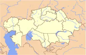
| Location in Kazakhstan | |||
| Coordinates: {{#invoke:Coordinates|coord}}{{#coordinates:43|16|39|N|76|53|45|E|type:city | |||
|---|---|---|---|
| name= }} | |||
| Country | | ||
| Province | Almaty Province | ||
| First settled | X-IX B.C. | ||
| Founded | 1854 | ||
| Incorporated (city) | 1867 | ||
| Government | |||
| - Akim (mayor) | Akhmetzhan Yesimov | ||
| Area | |||
| - Total | 324.8 km² (125.4 sq mi) | ||
| Elevation | 500 - 1,700 m (1,640 - 5,577 ft) | ||
| Population (2005) | |||
| - Total | 1,226,300 | ||
| - Density | 3,776/km² (9,779.8/sq mi) | ||
| Time zone | BTT (UTC+6) | ||
| Postal code | 050000 - 050063 | ||
| Area code(s) | +7 727[1] | ||
| ISO 3166-2 | ALA | ||
| License plate | A | ||
| Website: http://www.almaty.kz | |||
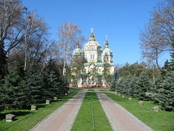
Almaty (Kazakh: Алматы; formerly known as Alma-Ata, also Verniy, (Верный)) is the largest city, major commercial center , and former capital of Kazakhstan.
The region is the ancestral home of the apple, and the wild Malus sieversii, now considered to be a likely candidate for the ancestor of the modern domestic apple, originates from the area around Almaty. The world's largest apple, reputedly close to watermelon size, came from Almaty.
Geography
The name "Almaty" means "rich with apple"; the older Soviet-era Russian version of its name, Alma-Ata, originates from a mistake (literally means "Grandfather-apple").
The city is located where the Great and Little Almaatinka rivers emerge in the south-eastern part of Kazakhstan, in northern foothills of the Trans-Ili Alatau mountains near China, at an elevation of 2300–3000 feet (700–900 meters),
The climate of Almaty is quite mild, when compared with the rest of Kazakhstan. Temperatures range from 4°F to 78°F (-15.5°C to 25.75°C). Rainfall varies from 1.6 to 6.8 inches (42mm to 174mm) each month.
Almaty extends about 12.5 miles (20km) from its centre. With wide, tree-lined streets, numerous parks and orchards, and a backdrop of mountains, it is considered one of the most beautiful cities of Kazakhstan.
The area is subject to both earthquakes and mud slides. The city suffered from severe earthquakes in 1887 and 1911, and a devastating mudflow down the Malaya Almaatinka River in 1921. To reduce the risk, blasting precipitated a landslide in 1966 to create a 330-foot (100-metre) dam across a gorge. In 1973, this dam contained a potentially catastrophic mud slide.
History

Bronze Age (c.3300 B.C.E. to 1200 B.C.E.) farmers and cattle-breeders established settlements on the territory of Almaty. Saka tribes and later Uisun tribes inhabited the territory north of the Tian Shan mountain range from 700 B.C.E. to the common era, during which time Almaty became the early education center.
From the 10th – 14th centuries, Almaty became one of the trade, craft and agricultural centers on the Silk Road and possessed an official mint. The city was first mentioned as Almatu in old books in the 13th century.
Mongols destroyed the ancient settlement of Almaty in the 13th century. Descendants of Turkic tribes, Mongol groups, and Indo-Iranian tribes coalesced into the Kazakh people close to Almaty from the 15th to 18th centuries.
The modern history of Almaty started on February 4, 1854, when the Russians established a fort named Zailiyskoye (renamed Verny in 1855) on the site of the ancient settlement of Almaty. It was a fenced pentagon and one of its sides was built along the river.
From 1856, Verniy started accepting Russian peasants, and Tatar mechants and craftsmen. In 1867 the Verniy Fort was transformed into a town called Almatinsk, later re-named again as Verniy. The city became the administrative centre of the new Semirechye province of Turkistan.
According to the First City Plan, the city parameters were 2km on the south along Almatinka river, and 3km on the west. The new city area was divided into residential parts, and the latter – into districts. Three categories of the city buildings were distinguished. Buildings of the first and second categories were two-storied or, at least, one-storied constructions with the high semi-basement. Buildings of categories I and II were erected around and in the center of the city, others – on the outskirts.
On May 28, 1887, at 4am, an earthquake lasting 11 to 12 minutes destroyed Verniy, mostly the brick buildings. As a result people tended to build single-storied constructions made of wood or adobe.
The population grew to 27,000 by 1906, two-thirds of whom were Russians and Ukrainians.
The city came under Soviet rule in 1918, and in 1921 Verniy adopted the Kazakh name Alma-Ata.
In 1927, the Kazakh capital was transferred from Kyzyl-Orda to Alma-Ata.
In 1930, the construction of the Turkestan-Siberia Railway railway to the Alma-Ata station was completed, and in that year the Alma-Ata airport was opened, making Alma-Ata the air gate to Kazakhstan. Both developments brought rapid growth, and the population rose from 46,000 in 1926 to 221,000 in 1939. In 1936, a new plan aimed to re-create Alma-Ata as the new cultural and comfortable capital of Kazakhstan.
During World War II, the city accommodated 26,000 persons evacuated from the European parts of the Soviet Union, hosted over 30 industrial facilities from the front areas, eight hospitals, 15 institutes, universities and technical schools, around 20 cultural institutions, etc. Motion picture production companies from Leningrad, Kiev and Moscow were also evacuated to Alma-Ata.
From 1966 to 1971, 1,400,000 square meters of public and cooperative housing were built, around 300,000 square meters each year. During this time earthquake-proof multi-storied buildings were built, including schools, hospitals, cultural and entertainment facilities, including the Lenin’s Palace, Kazakhstan Hotel, and the sport complex “Medeo”.
Since 1981, the underground Almaty Metro construction project has been developed.
On 16 December 1986 Jeltoksan riot took place in response to General Secretary Mikhail Gorbachev's dismissal of Dinmukhamed Kunayev.
After Kazakhstan obtained its independence from the Soviet Union in 1991, the Kazak form of the name, Almatym was adopted.
In 1994 the government began to transfer the national capital from Almaty to Aqmola ( named Astana since 1998). The transfer was completed in 1997.
On 1 July 1998 was passed the Law concerning the special status of Almaty as a scientific, cultural, historical, financial and industrial center.
The new 2030 General Plan of Almaty was developed in 1998 and aims at forming ecologically safe, secure and socially comfortable living conditions. The main objective is to promote Almaty’s image as a garden-city. One of the components of the General Plan is to continue multi-storied and individual construction, reorganize industrial territories, improve transport infrastructure and launch Almaty Metro.[citation needed]
Administration
Economy
Almaty is also developing as the regional financial and business centre - RFCA.
Demographics
with a population of 1,226,000 (as of 1 August 2005),[2] which represents 8% of the population of the country.
According to the USSR Census of 1989, population of Almaty was 1,071,900; Kazakhstan Census of 1999 reported 1,129,400.[3] Ethnic groups (2003):
- Kazakh 43.6 %
- Russian 40.2 %
- Uyghur 5.7 %
- Tatar 2.1 %
- Korean 1.8 %
- Ukrainian 1.7 %
- German 0.7 %
Universities of Almaty include:
- Almaty Institute of Power Engineering and Telecommunications
- Kazakh-British Technical University
- Kazakh National Technical University (KazNTU)
- Al-Farabi Kazakh National University (KazUU)
- Suleyman Demirel University (SDU)
- Kimep (Kazakhstan Institute of Management, Economics, and Strategic Research)
- Kazakh-American University (KAU)
- Kazakh Academy of Sciences
- Almaty State University (named after Abay)
- Turan University
- Kazakhstan University of Global Relationships and Languages (КазУМОиМЯ)
- Central Asian University (ЦАУ)
for further details: List of universities in Kazakhstan
Sights
Kök Töbe
An aerial tramway line connects downtown Almaty with a popular recreation area the top of Kök Töbe (Kazakh: Көктөбе, which means 'Green Hill'), a mountain just to the southeast. The city television tower, Alma-Ata Tower, is located on the hill, as well as a variety of amusement-park type attractions and touristy restaurants.
Fountains
According to the city's Department of Natural Resources and Resource Use Management,[4] as of 2007 the city has 125 fountain groups or isolated fountains. Among them is the "Oriental Calendar" Fountain, whose 12 sculpture figures represent the 12 animals of the Kazakh 12-year animal cycle (similar to its Chinese counterpart).
Olympic aspirations
Almaty was an official candidate to host the XXII Olympic Winter Games,[5] but was eliminated from consideration after it failed to be included in the "short list" of candidate cities. Almaty won its bid to host the 2011 Winter Asian Games.
See also
- Almaty International Airport
- Jeltoqsan - Kazakh nationwide revolt of 1986
- Names of Asian cities in different languages
- Medeo - speed skating rink
- Shymbulak - ski resort
- Kazakhstan International School
- FC Kairat Almaty
External links
- City of Almaty Official website (in Kazakh, English, and Russian)
- About Almаty City news and references communicator (only English language)
- Travel guide to Almaty from Wikitravel
- Almaty Layover Guide
- Timeout Almaty - Entertainment Guide
- Almaty Airport
- Almaty Guide
- Almaty Project of TU Berlin
- Almaty Fashion Week
- Nightlife Almaty
- Almaty Expat Site
- Almaty or Bust!
- Alatau IT CIty
- Satellite picture by Google Maps
- Culture Crash in Kazakhstan
- Up, Up and Away: New Towers, and Ambitions to Match - The New York Times
- Oh, the Places You’ll Go! - The New York Times Travel
- Almatylink
-
- Mapping from Multimap or GlobalGuide or Google Maps
- Satellite image from WikiMapia
- Mapping from OpenStreetMap
ReferencesISBN links support NWE through referral fees
- ↑ CODE OF ACCESS
- ↑ «С начала года население Алматы увеличилось на 1,4%» (in ru). Retrieved 26 July, 2007.
- ↑ О некоторых итогах переписи населения Казахстана (About some results of the Kazakhstan population census) (Russian)
- ↑ Фонтаны города Алматы (The Fountains of Almaty) (Russian)
- ↑ 2014 Winter Olympic Games Bids
- Ness, Immanuel. Encyclopedia of World Cities. M E Sharpe Reference, 1999. ISBN 0765680173.
External links
- Almaty Encyclopaedia Britannica, accessed June 24, 2008.
- FallingRain Map - elevation = 861m (red dots are railways)
Credits
New World Encyclopedia writers and editors rewrote and completed the Wikipedia article in accordance with New World Encyclopedia standards. This article abides by terms of the Creative Commons CC-by-sa 3.0 License (CC-by-sa), which may be used and disseminated with proper attribution. Credit is due under the terms of this license that can reference both the New World Encyclopedia contributors and the selfless volunteer contributors of the Wikimedia Foundation. To cite this article click here for a list of acceptable citing formats.The history of earlier contributions by wikipedians is accessible to researchers here:
The history of this article since it was imported to New World Encyclopedia:
Note: Some restrictions may apply to use of individual images which are separately licensed.


