Difference between revisions of "Petra" - New World Encyclopedia
Mary Anglin (talk | contribs) |
Mary Anglin (talk | contribs) (import newer version) |
||
| Line 1: | Line 1: | ||
{{Ready}} {{Images OK}} | {{Ready}} {{Images OK}} | ||
| − | {{ | + | {{coord|30|19|43|N|35|26|31|E|display=title}} |
{{Infobox World Heritage Site | {{Infobox World Heritage Site | ||
| WHS = Petra | | WHS = Petra | ||
| Line 15: | Line 15: | ||
| Link = http://whc.unesco.org/en/list/326 | | Link = http://whc.unesco.org/en/list/326 | ||
}} | }} | ||
| − | '''Petra''' (from | + | '''Petra''' (from URU $e-eh-{la}[-li].KI in Akkadian, "petra-πέτρα", ''cleft in the rock'' in [[Greek language|Greek]]; [[Arabic language|Arabic]]: البتراء, ''Al-Batrāʾ'') is an [[Archaeology|archaeological]] site in the [[Arabah]], Ma'an Governorate, [[Jordan]], lying on the slope of [[Mount Hor]]<ref name="WebsterNinthNewCollege">Mish, Frederick C., Editor in Chief. “Petra.” ''[[Webster's Dictionary#The Collegiate Dictionary|Webster’s Ninth New Collegiate Dictionary]]''. 9<sup>th</sup> ed. Springfield, MA: [[Merriam-Webster]] Inc., 1985. ISBN 0-87779-508-8, ISBN 0-87779-509-6 (indexed), and ISBN 0-87779-510-X (deluxe).</ref> in a [[Depression (geology)|basin]] among the mountains which form the eastern flank of [[Arabah]] (Wadi Araba), the large valley running from the [[Dead Sea]] to the [[Gulf of Aqaba]]. It is renowned for its [[rock-cut architecture]]. Petra is also one of the [[New Seven Wonders of the World|new wonders of the world]]. |
The site remained unknown to the Western world until 1812, when it was discovered by [[Switzerland|Swiss]] explorer [[Johann Ludwig Burckhardt]]. It was famously described as "a rose-red city half as old as time" in a [[Newdigate prize]]-winning [[sonnet]] by [[John William Burgon]]. UNESCO has described it as "one of the most precious cultural properties of man's cultural heritage."<ref name="unesco">[http://whc.unesco.org/archive/advisory_body_evaluation/326.pdf UNESCO advisory body evaluation]</ref> In 1985, Petra was designated a [[World Heritage Site]]. | The site remained unknown to the Western world until 1812, when it was discovered by [[Switzerland|Swiss]] explorer [[Johann Ludwig Burckhardt]]. It was famously described as "a rose-red city half as old as time" in a [[Newdigate prize]]-winning [[sonnet]] by [[John William Burgon]]. UNESCO has described it as "one of the most precious cultural properties of man's cultural heritage."<ref name="unesco">[http://whc.unesco.org/archive/advisory_body_evaluation/326.pdf UNESCO advisory body evaluation]</ref> In 1985, Petra was designated a [[World Heritage Site]]. | ||
==Geography== | ==Geography== | ||
| − | ''Rekem'' is an ancient name for Petra and appears in | + | '''Rekem''' is an ancient name for Petra and appears in [[Dead Sea scrolls]]<ref>4Q462</ref> associated with [[Mount Seir]]. Additionally, [[Eusebius of Caesarea|Eusebius]] and [[Jerome]]<ref>(Onom. sacr. 286, 71. 145, 9; 228, 55. 287, 94)</ref> assert that Rekem was the native name of Petra, supposedly on the authority of [[Josephus]].<ref>''[[Antiquities of the Jews|Antiquities]] iv. 7, 1~ 4, 7'')</ref> [[Pliny the Elder]] and other writers identify Petra as the capital of the [[Nabataeans]], [[Aramaic language|Aramaic]]-speaking [[Semitic|Semites]], and the centre of their [[camel train|caravan]] trade. Enclosed by towering rocks and watered by a perennial [[stream]], Petra not only possessed the advantages of a fortress, but controlled the main commercial routes which passed through it to [[Gaza]] in the west, to [[Bosra]] and [[Damascus]] in the north, to [[Aqaba]] and [[Leuce Come]] on the [[Red Sea]], and across the desert to the [[Persian Gulf]]. The latitude is 30° 19' 43" N and the longitude is 35° 26' 31" E. |
| − | + | [[Image:Entrance to Petra.JPG|thumb|left|The end of the Siq]] | |
| − | + | Excavations have demonstrated that it was the ability of the Nabataeans to control the water supply that led to the rise of the desert city, in effect creating an artificial [[oasis]]. The area is visited by [[flash flood]]s and archaeological evidence demonstrates the Nabataeans controlled these floods by the use of [[dam]]s, [[cistern]]s and water conduits. These innovations stored water for prolonged periods of [[drought]], and enabled the city to prosper from its sale.<ref>[http://nabataea.net/waterw.html Petra: Water Works<!-- Bot generated title —>]</ref><ref>[http://www.agiweb.org/geotimes/june04/feature_petra.html Geotimes — June 2004 — Petra: An Eroding Ancient City<!-- Bot generated title —>]</ref> | |
| − | A little further from the Treasury, at the foot of the mountain called ''en-Nejr'' is a massive | + | [[Image:PetraAmphitheatre.jpg|thumb|right|The Theatre]] |
| + | |||
| + | Although in ancient times Petra might have been approached from the south (via [[Saudi Arabia]] on a track leading around [[Mount Hor|Jabal Haroun]], ''Aaron's Mountain,'' on across the plain of Petra), or possibly from the high plateau to the north, most modern visitors approach the ancient site from the east. The impressive eastern entrance leads steeply down through a dark, narrow gorge (in places only 3–4 metres wide) called the ''[[Siq]]'' ("the shaft"), a natural geological feature formed from a deep split in the [[sandstone]] rocks and serving as a waterway flowing into [[Wadi Musa]]. At the end of the narrow gorge stands Petra's most elaborate ruin, [[Al Khazneh]] ("the Treasury"), hewn into the sandstone cliff. | ||
| + | |||
| + | [[Image:petraMonastery.JPG|thumb|left|The Monastery at Petra]] | ||
| + | |||
| + | A little further from the Treasury, at the foot of the mountain called ''en-Nejr'' is a massive theatre, so placed as to bring the greatest number of tombs within view. At the point where the valley opens out into the plain, the site of the city is revealed with striking effect. The [[amphitheatre]] has actually been cut into the hillside and into several of the tombs during its construction. Rectangular gaps in the seating are still visible. Almost enclosing it on three sides are rose-colored mountain walls, divided into groups by deep fissures, and lined with knobs cut from the rock in the form of towers. | ||
== History == | == History == | ||
| − | + | The History of Petra begins with the Kites and cairns of gazelle hunters going back into the acermaic neolithic. Evidence suggests that settlements had begun in and around there in the [[Eighteenth Dynasty of Egypt]]. It is listed in Egyptian campaign accounts and the Amarna letters as Pel, Sela or Seir). Though the city was founded relatively late, a sanctuary existed there since very ancient times. Stations 19 through 26 of the [[stations list]] of [[Exodus]] are places associated with Petra and it is refered to there as the cleft in the rock. | |
| + | <ref> | ||
| + | *25. Mithcah - Nu. 33:28-29 associated with Petra on the borders of Moab and Edom near Petra. | ||
| + | *26. Hashmonah - Nu. 33:29-30 Ha Shmona Kiryat Shmona South | ||
| + | *27. Moseroth - Nu. 33:30-31 described as the place where Aaron died at the foor of Mt Hor (Petra) | ||
| + | *28. Bene-Jaakan - Nu. 33:31-32 the wells of Jaakan Near Mt Hor (Petra) | ||
| + | *29. Petra - Nu. 33:32-33 Siq The cleft of the mountain, the entrance to Petra | ||
| + | </ref> | ||
| + | This part of the country was biblically assigned to the [[Horites]], the predecessors of the [[Edom]]ites.<ref>[[Genesis]] xiv. 6, xxxvi. 20–30; Deut. ii. 12.</ref> The habits of the original natives may have influenced the Nabataean custom of burying the dead and offering worship in half-excavated caves. Although Petra is usually identified with [[Sela]] which also means a ''rock,'' the Biblical references<ref>[[Book of Judges|Judges]] i. 36; [[Book of Isaiah|Isaiah]] xvi. i, xlii. 11; Obad. 3.</ref> refer to it as the cleft in the rock, referring to its entrance. 2 [[Books of Kings|Kings]] xiv. 7 seems to be more specific. In the parallel passage, however, Sela is understood to mean simply "the rock" (2 Chr. xxv. 12, see LXX). | ||
| + | |||
| + | On the authority of [[Josephus]] (''[[Antiquities of the Jews]]'' iv. 7, 1~ 4, 7), [[Eusebius of Caesarea|Eusebius]] and [[Jerome]] (''Onom. sacr.'' 286, 71. 145, 9; 228, 55. 287, 94), assert that '''Rekem''' was the native name and ''Rekem'' appears in the [[Dead Sea scrolls]] as a prominent Edom site most closely describing Petra. But in the Aramaic versions Rekem is the name of [[Kadesh (Israel)|Kadesh]], implying that Josephus may have confused the two places. Sometimes the Aramaic versions give the form ''Rekem-Geya'' which recalls the name of the village El-ji, southeast of Petra. The capital, however, would hardly be defined by the name of a neighboring village. The Semitic name of the city, if not Sela, remains unknown. The passage in [[Diodorus Siculus]] (xix. 94–97) which describes the expeditions which [[Antigonus I Monophthalmus|Antigonus]] sent against the Nabataeans in 312 B.C.E. is understood to throw some light upon the history of Petra, but the "petra" referred to as a natural fortress and place of refuge cannot be a proper name and the description implies that the town was not yet in existence. | ||
| − | + | [[File:RekemInscription.jpg|thumb|200px|left|The Rekem Inscription in 1976]] | |
| − | More satisfactory evidence of the date of the earliest Nabataean settlement may be obtained from an examination of the tombs. Two types may be distinguished—the Nabataean and the [[Greco-Roman]]. The Nabataean type starts from the simple pylon-tomb with a door set in a tower crowned by a parapet ornament, in imitation of the front of a dwelling-house. Then, after passing through various stages, the full Nabataean type is reached, retaining all the native features and at the same time exhibiting characteristics which are partly [[Egypt]]ian and partly [[Ancient Greece|Greek]]. Of this type there exist close parallels in the tomb-towers at el-I~ejr [?] in north Arabia, which bear long Nabataean inscriptions and supply a date for the corresponding monuments at Petra. Then comes a series of | + | More satisfactory evidence of the date of the earliest Nabataean settlement may be obtained from an examination of the tombs. Two types may be distinguished—the Nabataean and the [[Greco-Roman]]. The Nabataean type starts from the simple pylon-tomb with a door set in a tower crowned by a parapet ornament, in imitation of the front of a dwelling-house. Then, after passing through various stages, the full Nabataean type is reached, retaining all the native features and at the same time exhibiting characteristics which are partly [[Egypt]]ian and partly [[Ancient Greece|Greek]]. Of this type there exist close parallels in the tomb-towers at el-I~ejr [?] in north Arabia, which bear long Nabataean inscriptions and supply a date for the corresponding monuments at Petra. Then comes a series of tombfronts which terminate in a semicircular arch, a feature derived from north [[Syria]]. Finally come the elaborate façades copied from the front of a [[Roman temple]]; however, all traces of native style have vanished. The exact dates of the stages in this development cannot be fixed. Strangely, few inscriptions of any length have been found at Petra, perhaps because they have perished with the stucco or cement which was used upon many of the buildings. The simple pylon-tombs which belong to the pre-Hellenic age serve as evidence for the earliest period. It is not known how far back in this stage the Nabataean settlement goes, but it does not go back farther than the 6th century BC. |
| − | A period follows in which the dominant civilization combines Greek, Egyptian and Syrian elements, clearly pointing to the age of the [[Ptolemaic dynasty|Ptolemies]]. Towards the close of the | + | A period follows in which the dominant civilization combines Greek, Egyptian and Syrian elements, clearly pointing to the age of the [[Ptolemaic dynasty|Ptolemies]]. Towards the close of the 2nd century BC, when the Ptolemaic and [[Seleucid Empire|Seleucid]] kingdoms were equally depressed, the Nabataean kingdom came to the front. Under [[Aretas|Aretas III Philhellene]], (c.85–60 B.C.E.), the royal coins begin. The theatre was probably excavated at that time, and Petra must have assumed the aspect of a [[Hellenistic Greece|Hellenistic]] city. In the reign of [[Aretas IV Philopatris]], (9 BC–AD 40), the fine tombs of the el-I~ejr [?] type may be dated, and perhaps also the great High-place. |
| + | [[Image:Jordan-Petra.jpg|thumbnail|right|upright|Urn Tomb]] | ||
===Roman rule=== | ===Roman rule=== | ||
| − | In 106, when [[Cornelius Palma]] was governor of Syria, that part of Arabia under the rule of Petra was absorbed into the [[Roman Empire]] as part of [[Arabia Petraea]], becoming capital. The native dynasty came to an end. But the city continued to flourish. A century later, in the time of [[Alexander Severus]], when the city was at the height of its splendor, the issue of coinage comes to an end. There is no more building of sumptuous tombs, owing apparently to some sudden catastrophe, such as an invasion by the neo-[[Iran|Persia]]n power under the [[Sassanid Empire]]. Meanwhile, as [[Palmyra]] (fl. 130–270) grew in importance and attracted the Arabian trade away from Petra, the latter declined. It seems, however, to have lingered on as a religious centre. [[Epiphanius of Salamis]] (c.315–403) writes that in his time a feast was held there on December 25 in honor of the virgin [[Chaabou]] and her offspring [[Dushara]] (''Haer.'' 51).{{Fact|date=December 2007}} | + | In 106, when [[Cornelius Palma]] was governor of Syria, that part of Arabia under the rule of Petra was absorbed into the [[Roman Empire]] as part of [[Arabia Petraea]], becoming capital. The native dynasty came to an end. But the city continued to flourish. A century later, in the time of [[Alexander Severus]], when the city was at the height of its splendor, the issue of coinage comes to an end. There is no more building of sumptuous tombs, owing apparently to some sudden catastrophe, such as an invasion by the neo-[[Iran|Persia]]n power under the [[Sassanid Empire]]. Meanwhile, as [[Palmyra]] (fl. 130–270) grew in importance and attracted the Arabian trade away from Petra, the latter declined. It seems, however, to have lingered on as a religious centre. [[Epiphanius of Salamis]] (c.315–403) writes that in his time a feast was held there on [[December 25]] in honor of the virgin [[Chaabou]] and her offspring [[Dushara]] (''Haer.'' 51).{{Fact|date=December 2007}} |
===Religion=== | ===Religion=== | ||
The Nabataeans worshipped the Arab [[God (male deity)|gods]] and [[goddess]]es of the [[Pre-Islamic Arabia|pre-Islamic]] times as well as few of their [[Deifying|deified]] kings. The most famous of these was Obodas I who was deified after his death. Dushara was the main male god accompanied by his female trinity: [[Uzza]], [[Allat]] and [[Manah]]. Many statues carved in the rock depict these gods and goddesses. | The Nabataeans worshipped the Arab [[God (male deity)|gods]] and [[goddess]]es of the [[Pre-Islamic Arabia|pre-Islamic]] times as well as few of their [[Deifying|deified]] kings. The most famous of these was Obodas I who was deified after his death. Dushara was the main male god accompanied by his female trinity: [[Uzza]], [[Allat]] and [[Manah]]. Many statues carved in the rock depict these gods and goddesses. | ||
| − | The Monastery, Petra's largest monument, dates from the first century | + | The Monastery, Petra's largest monument, dates from the first century BC. It was dedicated to Obodas I and is believed to be the symposium of Obodas the god. This information is inscribed on the ruins of the Monastery (the name is the translation of the Arabic "Ad-Deir"). |
| − | [[Image: | + | [[Image:Petra Byzantine church plan.svg|thumb|tight|Plan of the Byzantine church, 5th century AD.]] |
| − | [[Christianity]] found its way into Petra in the 4th century AD, nearly 500 years after the establishment of Petra as a trade center. [[Athanasius of Alexandria|Athanasius]] mentions a bishop of Petra (Anhioch. 10) named Asterius. At least one of the tombs (the "tomb with the urn"?) was used as a church. An inscription in red paint records its consecration "in the time of the most holy bishop Jason" (447). The Christianity of Petra, as of north Arabia, was swept away by the [[Islam | + | [[Christianity]] found its way into Petra in the 4th century AD, nearly 500 years after the establishment of Petra as a trade center. [[Athanasius of Alexandria|Athanasius]] mentions a bishop of Petra (Anhioch. 10) named Asterius. At least one of the tombs (the "tomb with the urn"?) was used as a church. An inscription in red paint records its consecration "in the time of the most holy bishop Jason" (447). The Christianity of Petra, as of north Arabia, was swept away by the [[Islam]]ic conquest of 629–632. During the [[First Crusade]] Petra was occupied by [[Baldwin I of Jerusalem|Baldwin I]] of the [[Kingdom of Jerusalem]] and formed the second [[Fiefdom|fief]] of the [[Barony (country subdivision)|barony]] of [[Al Karak]] (in the lordship of [[Oultrejordain]]) with the title ''Château de la Valée de Moyse'' or Sela. It remained in the hands of the [[Franks]] until 1189. It is still a [[titular see]] of the [[Roman Catholic Church]].<ref>{{CathEncy|wstitle=Petra}}</ref> |
| − | According to Arab tradition, Petra is the spot where [[Moses]] struck a rock with his staff and water came forth, and where Moses' | + | According to Arab tradition, Petra is the spot where [[Moses]] struck a rock with his staff and water came forth, and where Moses' brother, [[Aaron]], is [[Tomb of Aaron|buried]], at [[Mount Hor]], known today as Jabal Haroun or Mount Aaron. The Wadi Musa or "Wadi of Moses" is the Arab name for the narrow valley at the head of which Petra is sited. A mountaintop shrine of Moses' sister Miriam was still shown to pilgrims at the time of Jerome in the fourth century, but its location has not been identified since.<ref>[http://www.sacredsites.com/middle_east/jordan/petra_ruins.htm Sacred Sites: Petra]</ref> |
===Decline=== | ===Decline=== | ||
| + | [[File:El_deir_petra_1_1839.jpg|thumb|tight|El Deir, in 1839, by [[David Roberts (painter)|David Roberts]].]] | ||
Petra declined rapidly under Roman rule, in large part due to the revision of sea-based trade routes. In 363 an earthquake destroyed many buildings, and crippled the vital water management system.<ref>[http://query.nytimes.com/gst/fullpage.html?res=9D03E3DF143EF934A25753C1A9659C8B63 ART REVIEW; Rose-Red City Carved From the Rock - New York Times<!-- Bot generated title —>]</ref> The ruins of Petra were an object of curiosity in the [[Middle Ages]] and were visited by the [[Sultan]] [[Baibars]] of Egypt towards the close of the 13th century. The first European to describe them was [[Johann Ludwig Burckhardt]] in 1812. | Petra declined rapidly under Roman rule, in large part due to the revision of sea-based trade routes. In 363 an earthquake destroyed many buildings, and crippled the vital water management system.<ref>[http://query.nytimes.com/gst/fullpage.html?res=9D03E3DF143EF934A25753C1A9659C8B63 ART REVIEW; Rose-Red City Carved From the Rock - New York Times<!-- Bot generated title —>]</ref> The ruins of Petra were an object of curiosity in the [[Middle Ages]] and were visited by the [[Sultan]] [[Baibars]] of Egypt towards the close of the 13th century. The first European to describe them was [[Johann Ludwig Burckhardt]] in 1812. | ||
| Line 58: | Line 76: | ||
==Petra today== | ==Petra today== | ||
| − | On December 6, 1985 Petra was designated a [[World Heritage Site]]. | + | On [[December 6]], [[1985]], Petra was designated a [[World Heritage Site]]. |
In 2006 a team of architects began designing a "Visitor Centre," and Jordan's tourist revenue is expected to increase dramatically with the attraction of visitors on [[package holiday]]s. The ''[[Jordan Times]]'' reported in December 2006 that 59,000 people visited in the two months October and November 2006, 25% fewer than the same period in the previous year, which may suggest that the flow of visitors may be affected by perception of political instability or travel safety considerations.<ref>[http://www.jordanembassyus.org/12152006002.htm 31,926 tourists visit Petra last month<!-- Bot generated title —>]</ref> | In 2006 a team of architects began designing a "Visitor Centre," and Jordan's tourist revenue is expected to increase dramatically with the attraction of visitors on [[package holiday]]s. The ''[[Jordan Times]]'' reported in December 2006 that 59,000 people visited in the two months October and November 2006, 25% fewer than the same period in the previous year, which may suggest that the flow of visitors may be affected by perception of political instability or travel safety considerations.<ref>[http://www.jordanembassyus.org/12152006002.htm 31,926 tourists visit Petra last month<!-- Bot generated title —>]</ref> | ||
| − | On July 7 2007, Petra was named one of New Open World Corporation's [[New Seven Wonders of the World]]. | + | On [[July 7]] [[2007]], Petra was named one of New Open World Corporation's [[New Seven Wonders of the World]].<ref>[http://www.new7wonders.com/classic/en/n7w/results/ The Official New 7 Wonders of the Modern World]</ref> |
| − | [[ | + | == Media appearances == |
| − | [[ | + | |
| − | [[ | + | The picturesque site is a popular sight and featured in various works of art such as the movies ''[[Indiana Jones and the Last Crusade]]'', ''[[Passion in the Desert]]'', ''[[Mortal Kombat: Annihilation]]'', ''[[Sinbad and the Eye of the Tiger]]'', and the [[The Sisters of Mercy|Sisters of Mercy]] music video "Dominion". It was recreated for the video games ''[[Spy Hunter (2001 video game)|Spy Hunter]]'', ''[[Lego Indiana jones]]'' and [[Sonic Unleashed]] and appeared in the novels "[[Left Behind]]", "[[Appointment with Death]]", "[[Eagle Series|The Eagle in the Sand]]" and "[[The Red Sea Sharks]]", in [[The Adventures of Tintin]]. |
| − | [[ | ||
| − | [[ | ||
| − | [[ | ||
| − | [[ | ||
| + | ==Photo gallery== | ||
<gallery> | <gallery> | ||
| + | Image:Petra-Ray1.JPG|The "Treasury" | ||
| + | Image:Petra-Ray3.JPG|Particular of the "Treasury" | ||
| + | Image:Petra-Ray2.JPG|View of the monastery | ||
</gallery> | </gallery> | ||
| − | |||
| − | |||
| − | |||
| − | |||
| − | |||
| − | |||
| − | |||
| − | |||
| − | |||
| − | |||
| − | |||
| − | |||
| − | |||
== Notes == | == Notes == | ||
| Line 93: | Line 98: | ||
== References == | == References == | ||
* Bedal, Leigh-Ann. 2004. ''The Petra pool-complex: a Hellenistic paradeisos in the Nabataean capital : (results from the Petra "Lower Market" survey and excavation, 1998)''. Piscataway, NJ, USA: Gorgias Press. ISBN 1593331207 and ISBN 9781593331207 | * Bedal, Leigh-Ann. 2004. ''The Petra pool-complex: a Hellenistic paradeisos in the Nabataean capital : (results from the Petra "Lower Market" survey and excavation, 1998)''. Piscataway, NJ, USA: Gorgias Press. ISBN 1593331207 and ISBN 9781593331207 | ||
| + | *''Go 2 Petra''. [http://www.go2petra.com Petra Guide] Retrieved January 11, 2009. | ||
* Harty, Rosemary. 2006. [http://www.digitaljournalist.org/issue0607/petra.html The Bedouin Tribes of Petra]. ''The Digital Journalist''. Retrieved May 10, 2008. | * Harty, Rosemary. 2006. [http://www.digitaljournalist.org/issue0607/petra.html The Bedouin Tribes of Petra]. ''The Digital Journalist''. Retrieved May 10, 2008. | ||
* Hill, John E. 2004. ''The Peoples of the West from the Weilue''. | * Hill, John E. 2004. ''The Peoples of the West from the Weilue''. | ||
| Line 98: | Line 104: | ||
==External links== | ==External links== | ||
| + | All Links Retrieved January 11, 2009. | ||
*[http://www.visitjordan.com/default.aspx?tabid=242 Information on Petra on the Jordan Tourism Board] | *[http://www.visitjordan.com/default.aspx?tabid=242 Information on Petra on the Jordan Tourism Board] | ||
*[http://youtube.com/watch?v=52bL0M9z_PM Historic film of Petra, circa 1966] | *[http://youtube.com/watch?v=52bL0M9z_PM Historic film of Petra, circa 1966] | ||
| − | + | *[http://www.smartedaleel.com/allaboutjordan/interactive-jordan/79-interactive-map-of-petra.html Interactive map of Old Petra] | |
| − | + | *[http://www.caramccain.com/archaeology.html Petra Pictures] | |
| + | *[http://www.myworldshots.com/Jordan/Petra World photos. Petra.] | ||
[[Category:History]] | [[Category:History]] | ||
[[Category:Geography]] | [[Category:Geography]] | ||
| − | + | [[Category:World Heritage Sites]] | |
| − | + | [[Category:Asia]] | |
| + | [[Category:Middle East]] | ||
{{credit|210147529}} | {{credit|210147529}} | ||
Revision as of 03:22, 11 January 2009
Coordinates:
| Petra* | |
|---|---|
| UNESCO World Heritage Site | |

| |
| State Party | |
| Type | Cultural |
| Criteria | i, iii, iv |
| Reference | 326 |
| Region** | Arab States |
| Inscription history | |
| Inscription | 1985 (9th Session) |
| * Name as inscribed on World Heritage List. ** Region as classified by UNESCO. | |
Petra (from URU $e-eh-{la}[-li].KI in Akkadian, "petra-πέτρα", cleft in the rock in Greek; Arabic: البتراء, Al-Batrāʾ) is an archaeological site in the Arabah, Ma'an Governorate, Jordan, lying on the slope of Mount Hor[1] in a basin among the mountains which form the eastern flank of Arabah (Wadi Araba), the large valley running from the Dead Sea to the Gulf of Aqaba. It is renowned for its rock-cut architecture. Petra is also one of the new wonders of the world.
The site remained unknown to the Western world until 1812, when it was discovered by Swiss explorer Johann Ludwig Burckhardt. It was famously described as "a rose-red city half as old as time" in a Newdigate prize-winning sonnet by John William Burgon. UNESCO has described it as "one of the most precious cultural properties of man's cultural heritage."[2] In 1985, Petra was designated a World Heritage Site.
Geography
Rekem is an ancient name for Petra and appears in Dead Sea scrolls[3] associated with Mount Seir. Additionally, Eusebius and Jerome[4] assert that Rekem was the native name of Petra, supposedly on the authority of Josephus.[5] Pliny the Elder and other writers identify Petra as the capital of the Nabataeans, Aramaic-speaking Semites, and the centre of their caravan trade. Enclosed by towering rocks and watered by a perennial stream, Petra not only possessed the advantages of a fortress, but controlled the main commercial routes which passed through it to Gaza in the west, to Bosra and Damascus in the north, to Aqaba and Leuce Come on the Red Sea, and across the desert to the Persian Gulf. The latitude is 30° 19' 43" N and the longitude is 35° 26' 31" E.

Excavations have demonstrated that it was the ability of the Nabataeans to control the water supply that led to the rise of the desert city, in effect creating an artificial oasis. The area is visited by flash floods and archaeological evidence demonstrates the Nabataeans controlled these floods by the use of dams, cisterns and water conduits. These innovations stored water for prolonged periods of drought, and enabled the city to prosper from its sale.[6][7]

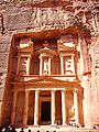
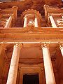
Although in ancient times Petra might have been approached from the south (via Saudi Arabia on a track leading around Jabal Haroun, Aaron's Mountain, on across the plain of Petra), or possibly from the high plateau to the north, most modern visitors approach the ancient site from the east. The impressive eastern entrance leads steeply down through a dark, narrow gorge (in places only 3–4 metres wide) called the Siq ("the shaft"), a natural geological feature formed from a deep split in the sandstone rocks and serving as a waterway flowing into Wadi Musa. At the end of the narrow gorge stands Petra's most elaborate ruin, Al Khazneh ("the Treasury"), hewn into the sandstone cliff.

A little further from the Treasury, at the foot of the mountain called en-Nejr is a massive theatre, so placed as to bring the greatest number of tombs within view. At the point where the valley opens out into the plain, the site of the city is revealed with striking effect. The amphitheatre has actually been cut into the hillside and into several of the tombs during its construction. Rectangular gaps in the seating are still visible. Almost enclosing it on three sides are rose-colored mountain walls, divided into groups by deep fissures, and lined with knobs cut from the rock in the form of towers.
History
The History of Petra begins with the Kites and cairns of gazelle hunters going back into the acermaic neolithic. Evidence suggests that settlements had begun in and around there in the Eighteenth Dynasty of Egypt. It is listed in Egyptian campaign accounts and the Amarna letters as Pel, Sela or Seir). Though the city was founded relatively late, a sanctuary existed there since very ancient times. Stations 19 through 26 of the stations list of Exodus are places associated with Petra and it is refered to there as the cleft in the rock. [8] This part of the country was biblically assigned to the Horites, the predecessors of the Edomites.[9] The habits of the original natives may have influenced the Nabataean custom of burying the dead and offering worship in half-excavated caves. Although Petra is usually identified with Sela which also means a rock, the Biblical references[10] refer to it as the cleft in the rock, referring to its entrance. 2 Kings xiv. 7 seems to be more specific. In the parallel passage, however, Sela is understood to mean simply "the rock" (2 Chr. xxv. 12, see LXX).
On the authority of Josephus (Antiquities of the Jews iv. 7, 1~ 4, 7), Eusebius and Jerome (Onom. sacr. 286, 71. 145, 9; 228, 55. 287, 94), assert that Rekem was the native name and Rekem appears in the Dead Sea scrolls as a prominent Edom site most closely describing Petra. But in the Aramaic versions Rekem is the name of Kadesh, implying that Josephus may have confused the two places. Sometimes the Aramaic versions give the form Rekem-Geya which recalls the name of the village El-ji, southeast of Petra. The capital, however, would hardly be defined by the name of a neighboring village. The Semitic name of the city, if not Sela, remains unknown. The passage in Diodorus Siculus (xix. 94–97) which describes the expeditions which Antigonus sent against the Nabataeans in 312 B.C.E. is understood to throw some light upon the history of Petra, but the "petra" referred to as a natural fortress and place of refuge cannot be a proper name and the description implies that the town was not yet in existence.

More satisfactory evidence of the date of the earliest Nabataean settlement may be obtained from an examination of the tombs. Two types may be distinguished—the Nabataean and the Greco-Roman. The Nabataean type starts from the simple pylon-tomb with a door set in a tower crowned by a parapet ornament, in imitation of the front of a dwelling-house. Then, after passing through various stages, the full Nabataean type is reached, retaining all the native features and at the same time exhibiting characteristics which are partly Egyptian and partly Greek. Of this type there exist close parallels in the tomb-towers at el-I~ejr [?] in north Arabia, which bear long Nabataean inscriptions and supply a date for the corresponding monuments at Petra. Then comes a series of tombfronts which terminate in a semicircular arch, a feature derived from north Syria. Finally come the elaborate façades copied from the front of a Roman temple; however, all traces of native style have vanished. The exact dates of the stages in this development cannot be fixed. Strangely, few inscriptions of any length have been found at Petra, perhaps because they have perished with the stucco or cement which was used upon many of the buildings. The simple pylon-tombs which belong to the pre-Hellenic age serve as evidence for the earliest period. It is not known how far back in this stage the Nabataean settlement goes, but it does not go back farther than the 6th century B.C.E.
A period follows in which the dominant civilization combines Greek, Egyptian and Syrian elements, clearly pointing to the age of the Ptolemies. Towards the close of the 2nd century B.C.E., when the Ptolemaic and Seleucid kingdoms were equally depressed, the Nabataean kingdom came to the front. Under Aretas III Philhellene, (c.85–60 B.C.E.), the royal coins begin. The theatre was probably excavated at that time, and Petra must have assumed the aspect of a Hellenistic city. In the reign of Aretas IV Philopatris, (9 B.C.E.–AD 40), the fine tombs of the el-I~ejr [?] type may be dated, and perhaps also the great High-place.

Roman rule
In 106, when Cornelius Palma was governor of Syria, that part of Arabia under the rule of Petra was absorbed into the Roman Empire as part of Arabia Petraea, becoming capital. The native dynasty came to an end. But the city continued to flourish. A century later, in the time of Alexander Severus, when the city was at the height of its splendor, the issue of coinage comes to an end. There is no more building of sumptuous tombs, owing apparently to some sudden catastrophe, such as an invasion by the neo-Persian power under the Sassanid Empire. Meanwhile, as Palmyra (fl. 130–270) grew in importance and attracted the Arabian trade away from Petra, the latter declined. It seems, however, to have lingered on as a religious centre. Epiphanius of Salamis (c.315–403) writes that in his time a feast was held there on December 25 in honor of the virgin Chaabou and her offspring Dushara (Haer. 51).[citation needed]
Religion
The Nabataeans worshipped the Arab gods and goddesses of the pre-Islamic times as well as few of their deified kings. The most famous of these was Obodas I who was deified after his death. Dushara was the main male god accompanied by his female trinity: Uzza, Allat and Manah. Many statues carved in the rock depict these gods and goddesses.
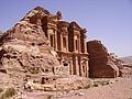
The Monastery, Petra's largest monument, dates from the first century B.C.E. It was dedicated to Obodas I and is believed to be the symposium of Obodas the god. This information is inscribed on the ruins of the Monastery (the name is the translation of the Arabic "Ad-Deir").

Christianity found its way into Petra in the 4th century AD, nearly 500 years after the establishment of Petra as a trade center. Athanasius mentions a bishop of Petra (Anhioch. 10) named Asterius. At least one of the tombs (the "tomb with the urn"?) was used as a church. An inscription in red paint records its consecration "in the time of the most holy bishop Jason" (447). The Christianity of Petra, as of north Arabia, was swept away by the Islamic conquest of 629–632. During the First Crusade Petra was occupied by Baldwin I of the Kingdom of Jerusalem and formed the second fief of the barony of Al Karak (in the lordship of Oultrejordain) with the title Château de la Valée de Moyse or Sela. It remained in the hands of the Franks until 1189. It is still a titular see of the Roman Catholic Church.[11]
According to Arab tradition, Petra is the spot where Moses struck a rock with his staff and water came forth, and where Moses' brother, Aaron, is buried, at Mount Hor, known today as Jabal Haroun or Mount Aaron. The Wadi Musa or "Wadi of Moses" is the Arab name for the narrow valley at the head of which Petra is sited. A mountaintop shrine of Moses' sister Miriam was still shown to pilgrims at the time of Jerome in the fourth century, but its location has not been identified since.[12]
Decline

Petra declined rapidly under Roman rule, in large part due to the revision of sea-based trade routes. In 363 an earthquake destroyed many buildings, and crippled the vital water management system.[13] The ruins of Petra were an object of curiosity in the Middle Ages and were visited by the Sultan Baibars of Egypt towards the close of the 13th century. The first European to describe them was Johann Ludwig Burckhardt in 1812.
Because the structures weakened with age, many of the tombs became vulnerable to thieves, and many treasures were stolen and remain unknown.
Petra today
On December 6, 1985, Petra was designated a World Heritage Site.
In 2006 a team of architects began designing a "Visitor Centre," and Jordan's tourist revenue is expected to increase dramatically with the attraction of visitors on package holidays. The Jordan Times reported in December 2006 that 59,000 people visited in the two months October and November 2006, 25% fewer than the same period in the previous year, which may suggest that the flow of visitors may be affected by perception of political instability or travel safety considerations.[14]
On July 7 2007, Petra was named one of New Open World Corporation's New Seven Wonders of the World.[15]
Media appearances
The picturesque site is a popular sight and featured in various works of art such as the movies Indiana Jones and the Last Crusade, Passion in the Desert, Mortal Kombat: Annihilation, Sinbad and the Eye of the Tiger, and the Sisters of Mercy music video "Dominion". It was recreated for the video games Spy Hunter, Lego Indiana jones and Sonic Unleashed and appeared in the novels "Left Behind", "Appointment with Death", "The Eagle in the Sand" and "The Red Sea Sharks", in The Adventures of Tintin.
Photo gallery
The "Treasury"
Particular of the "Treasury"
View of the monastery


Notes
- ↑ Mish, Frederick C., Editor in Chief. “Petra.” Webster’s Ninth New Collegiate Dictionary. 9th ed. Springfield, MA: Merriam-Webster Inc., 1985. ISBN 0-87779-508-8, ISBN 0-87779-509-6 (indexed), and ISBN 0-87779-510-X (deluxe).
- ↑ UNESCO advisory body evaluation
- ↑ 4Q462
- ↑ (Onom. sacr. 286, 71. 145, 9; 228, 55. 287, 94)
- ↑ Antiquities iv. 7, 1~ 4, 7)
- ↑ Petra: Water Works
- ↑ Geotimes — June 2004 — Petra: An Eroding Ancient City
- ↑
- 25. Mithcah - Nu. 33:28-29 associated with Petra on the borders of Moab and Edom near Petra.
- 26. Hashmonah - Nu. 33:29-30 Ha Shmona Kiryat Shmona South
- 27. Moseroth - Nu. 33:30-31 described as the place where Aaron died at the foor of Mt Hor (Petra)
- 28. Bene-Jaakan - Nu. 33:31-32 the wells of Jaakan Near Mt Hor (Petra)
- 29. Petra - Nu. 33:32-33 Siq The cleft of the mountain, the entrance to Petra
- ↑ Genesis xiv. 6, xxxvi. 20–30; Deut. ii. 12.
- ↑ Judges i. 36; Isaiah xvi. i, xlii. 11; Obad. 3.
- ↑ [[wikisource:Catholic Encyclopedia (1913)/Petra "|Petra]".] Catholic Encyclopedia. (1913). New York: Robert Appleton Company.
- ↑ Sacred Sites: Petra
- ↑ ART REVIEW; Rose-Red City Carved From the Rock - New York Times
- ↑ 31,926 tourists visit Petra last month
- ↑ The Official New 7 Wonders of the Modern World
ReferencesISBN links support NWE through referral fees
- Bedal, Leigh-Ann. 2004. The Petra pool-complex: a Hellenistic paradeisos in the Nabataean capital : (results from the Petra "Lower Market" survey and excavation, 1998). Piscataway, NJ, USA: Gorgias Press. ISBN 1593331207 and ISBN 9781593331207
- Go 2 Petra. Petra Guide Retrieved January 11, 2009.
- Harty, Rosemary. 2006. The Bedouin Tribes of Petra. The Digital Journalist. Retrieved May 10, 2008.
- Hill, John E. 2004. The Peoples of the West from the Weilue.
- Reid, Sara Karz. 2005. The small temple: a Roman imperial cult building in Petra, Jordan. Piscataway, NJ: Gorgias Press. ISBN 1593333390 and ISBN 9781593333393
External links
All Links Retrieved January 11, 2009.
- Information on Petra on the Jordan Tourism Board
- Historic film of Petra, circa 1966
- Interactive map of Old Petra
- Petra Pictures
- World photos. Petra.
Credits
New World Encyclopedia writers and editors rewrote and completed the Wikipedia article in accordance with New World Encyclopedia standards. This article abides by terms of the Creative Commons CC-by-sa 3.0 License (CC-by-sa), which may be used and disseminated with proper attribution. Credit is due under the terms of this license that can reference both the New World Encyclopedia contributors and the selfless volunteer contributors of the Wikimedia Foundation. To cite this article click here for a list of acceptable citing formats.The history of earlier contributions by wikipedians is accessible to researchers here:
The history of this article since it was imported to New World Encyclopedia:
Note: Some restrictions may apply to use of individual images which are separately licensed.