Kumgangsan
| KŭGeumgangsan ("Diamond Mountain") | |
|---|---|
| Korean Name | |
| McCune-Reischauer | Kŭmgangsan |
| Revised Romanization | Geumgangsan |
| Hangul | 금강산 |
| Hanja | 金剛山 |
| Statistics | |
| Height | 1,638 meters |
| Location | Kŭmgangsan Tourist Region, North Korea |

| |
Kŭmgangsan or Diamond Mountain is the second highest mountain in North Korea, with its highest peak, Pirobong, reaching 1,638 m. Kŭmgangsan, part of the Taebaek mountain range which runs along the east of the Korean peninsula, is located at 38.58 N latitude, 128.17 E longitude, in the recently created Kŭmgangsan Tourist Region, formerly part of Kangwŏn Province. Kŭmgangsan was the first place in North Korea opened up to allow visits by South Korean tour groups, beginning in 1998.
Natural Beauty
Kŭmgangsan has been known for its beauty since antiquity. It is covered in forests, and the area around Kŭmgangsan has some of the highest levels of precipitation in Korea. The mountain not only features a landscape formed by erosion, but also a great number of deep ponds and waterfalls.
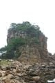
The mountain consists almost entirely of Granite and diorite, which have been weathered over centuries to create a wide variety of shapes. It is estimated that there are over 12,000 picturesque stone formations, ravines, cliffs, stone pillars and peaks.
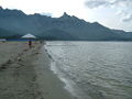
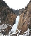
Kŭmgangsan is commonly divided into three areas: Inner Kŭmgang, Outer Kŭmgang, and Sea Kŭmgang, each with different geological and topographical features. Inner Kŭmgang is noted for its views. The Manpok ravine is popular with tourists. Outer Kŭmgang is noted for the large number of peaks, such as Jipson Peak (rock of ten thousand formations), with its many waterfalls. The Sea Kŭmgang area is known for its lagoons and stone pillars.
There are many old temples around Kŭmgangsan, although not all are preserved in good condition. Probably the best known temples are Jangan-sa and Maha-yon. Other features of the area include: Sea Manmulsang, Kŭmgang Gate, Samil Lagoon, Piro Peak, Myongyong rock, the Baektap ravine, Manmulsang, Kuryong pond, the Upper Pal pools, Sujong Peak, Ongnyu ravine, the Hanha Stream, and the Sibi waterfalls.
Kŭmgangsan Tourist Region
Since the Korean war in the early 1950's, there has been no surface traffic permitted between North and South Korea, and the few South Korean tourists who were permitted to visit the North had to fly there via a third country, usually China or Japan. Since 1998, South Korean tourists have been allowed to visit Kŭmgangsan, initially traveling by cruise ship, but recently more commonly by. In 2002, the area around the mountain was separated from Kangwŏn Province and organized as a separately administered Tourist Region. The land route connecting the region to South Korea was re-opened in 2003. A rail link exists on the North Korean side up to the border, but no tracks are laid between Gangneung and the border in South Korea.
The Kŭmgangsan Tourist Region is thought to be one way for the North Korean government to receive hard currency from abroad. Therefore the official currency of the tour is neither the South Korean won nor the North Korean won, but the US Dollar. Since 2003 the food and lodging services for the South Korean tourists have been provided by North Koreans staff. The area is being developed by Hyundai Asan, who operate the tours and aho have plans to expand the site with a proper ski resort to complement the current sleigh course, and complete golf courses. Many plans for expansion, however, are in their earliest stages. Since 1998 an average of approximately 200,000 tourists a year have visited the Kŭmgangsan area. In June 2005 Hyundai Asan announced the 1 millionth South Korean visitor to the area.
Natural wonders of Kǔmgangsan
The Diamond Mountains are one of the most spectacular tourist sights in Korea, including ragged cliffs, waterfalls, lagoons and mineral springs, rock formations, peaks and valleys
Inner Kǔmgangsan
Outer Kǔmgangsan
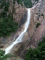
- Kuryong Falls (Nine Dragons Waterfall), with a drop of 74 meters, are an impressive site. Legend says that nine dragons once inhabited Kuryong Lake, the pool at the foot of the falls. Hiking further up from Kuryong Lake, you can reach Kuryong Rock, with a spectacular view of deep valleys and high elevation lakes.
- Manmulsang is an area of fantastically shaped cliffs and rocks. At the entrance to Manmulsang is a group of three enormous standing rocks named the Three Fairies (Samsǒn).
Sea Kǔmgangsan
- Samilpo Lagoon. According to legend, a king once came to the lagoon for a one-day visit but was so amazed by its beauty that he stayed there for three days, hence the name Samil (three days). You can rent a boat at Samilpo.
Buddhist temples and Hermitages
Pyohon Temple, in the Inner Kǔmgang area, is one of the most important Seon (Zen) monasteries in Korea. Many of the temple's cultural assets were lost during the period of Japanese rule.
edit in; Located over Goseong-gun, Tongcheongun, and Geumgang-gun in Gangwon-do, the Geumgangsan Diamond mountains are highly praised worldwide for their magnificent beauty. Mt. Geumgangsan stretches 40 kilometers east and west and 60 kilometers south and north, covering 530km2. The mountains were named Geumgangsan since their countless hard rocks and sparkling beauty are like a diamond, a Geumgangseok in Korean. Showing its unique beauty with its pointy granite peaks, Mt. Geumgangsan has as many as 12,000 rugged pinnacles including the highest Birobong peak (1638.2 meters), and countless rock formations that are breathtaking. Mt. Geumgangsan can be divided into three areas. On the east side of the mountain is Oegeumgang, the outer mountains, which is considered as a masculine manifestation with rugged terrains and magnificent waterfalls. Naegeumgang, the inner mountains on the west, displays a softer side with a plenty of streams and pools creating the splendid beauty of mountain valleys. Last but not least,Haegeumgang seashore area features picturesque sceneries with rock columns of various shapes off to the East sea. The mountainscape changes so distinctively with the change of four seasons that four different names are given to it. It is called Mt. Geumgangsan or the diamond mountain in spring, Mt. Bongraesan or the verdant mountain in summer, Mt. Pungaksan or the autumnal foliage mountain in autumn, and Mt. Gaegolsan or the skeleton mountain in winter.
edit in outer kumgang: Okryudong Valley Okryudong has the most splendid valleys along the outer mountains. Down the valley lies Okryudam, the biggest and widest pool in Mt. Geumgangsan. Guryong Falls Guryong Falls, one of the three most famous waterfalls in Korea, command a spectacular view with waterfalls cascading from a 150 meter-high cliff. The waterfalls are often praised as commanding the most spectacular scenery in Mt. Geumgangsan together with Manmulsang, the Stone Images of Ten Thousand Things. Visitors can also appreciate the beauty of the waterfalls at Guryonggak pavilion. The Sangpaldam Pools Crossing Yeondamgyo Bridge hanging over Guryong Falls and climbing a steep steel path of 370 stairs, visitors will reach the Guryongdae Cliff observatory which stands at 880 meters above sea level. The cliff commands a breathtaking scenery below, where Sangpaldam, the Eight Upper pools, is radiating in beauty. Ansimdae Cliff, Mangjangcheon Spring, Haneulmun Gate Ansimdae Cliff is the first spot welcoming tourists in the Manmulsang area. Under a big stone wall is Mangjangcheon Spring, left of the cliff. Mangjangcheon got its name as the spring that has so much water, a climber can even forget to take his walking stick. Following this steep trail, Haneulmun, the heaven gate, which is a big hole in the middle of rock walls, appears. Haneulmun is also called “Manmulsang Geumgangmun” or “Cheonilmun.” Tourists can reach the gate by climbing the steel ladders that are attached. Cheonseondae Cliff Located in the middle of the Manmulsang area, Cheonseondae has a breathtaking panoramic view of Oegeumgang, the outer mountains. Mangyangdae Cliff Mangyangdae observation platform presents picturesque views of magnificent pinnacles of the outer mountains as well as Birobong Peak and splendid islets of the Haegeumgang area. As the name Haegeumgang or Sea Diamonds indicates, the area is beautiful as if Mt. Geumgangsan were taken out into the sea. The seascape stretching about 40 kilometers includes Haemanmulsang, the Stone Images of Ten Thousand Things in the Sea, Ipseok Rock, and Chilseongseok Rock. The Haegeumgang course is divided into three districts which are Samilpo Lake, Haegeumgang Seashore, and Chongseokjeong Pavilion. Samilpo Lake District Samilpo is a lake with the circumference of about 8 kilometers, and the depth of 9 to 13 meters. The north of the lake is surrounded by 36 low peaks of Mt. Geumgangsan. To the right at the district’s entrance is a trail leading to Janggundae and Chungseonggak pavilion which offers a full view of Samilpo Lake. Below is a 56-meter long suspension bridge, the longest one in Mt. Geumgangsan. The district’s major tourist attractions include Waudo Islet in the shape of a big cow lying on the ground, Bongraedae where tourists can enjoy an unobstructed view of the lake at the highest point, and Yeonhwadae Pavilion where the highest Birobong Peak can be seen. Haegeumgang’s Seashore District Located 4 kilometers east of Samilpo Lake, Haegeumgang Seashore features an amazing scenery with breathtaking rock formations stretching out to the sea. Taking a cue from Manmulsang in the outer mountains, the oddlyshaped rocks are called Haemanmulsang, which means the Stones Images of Ten Thousand Things in the Sea. A must-see in this district is Songdo, a rocky islet rising about 50 meters above sea level. Chongseokjeong Pavilion District A 36-kilometer drive north along a seaside road from Goseonghang Port brings tourists to Chongseokjeong in Gojeo-eup, Tongcheongun. As the name, Chong-seokjeong, means clusters of rocks, this district features a kilometer-long stretch of cliffs along the coastline with thousands of high rock columns in various shapes rising above the sea. Chongseokjeong Pavilion used to mark this spot, though it is long gone. This district is not yet open to tourists. Dongseokdong Valley At Dongseokdong, a valley between Jipseonbong Peak and Sejonbong Peak, is the Yeongchundae area where spring is believed to first arrive at Mt. Geumgangsan. Dongseokdong Valley offers splendid views of a series of ridges, Jipseonbong Peak, and the East sea. Sejonbong Peak Sejonbong is to the left side of the trail from Okryudong Valley to Guryong Falls. Sejonbong provides an unobstructed view of magnificent outer mountains including Birobong Peak. Sujeongbong Peak Spiraling upward high towards the northwest of Onjeong-ri stands Sujeongbong. It is so abundant in granite and rock crystals that the peak was said to appear sparkling in the past. Rock crystals shining in granite can still be seen after it rains. The peak's observatory platform with enough space for 200 people offers a splendid view . Atop the peak is a wide area where nearly 1,000 people can sit and take a rest.
edit in Naegeumgang, the Inner Mountains While Oegeumgang features a masculine composition of Mt. Geumgangsan, Naegeumgang or the inner mountains can be seen as a softer, feminine counterpart. Naegeumgang course starts from Naegangdong Valley, which is about 43 kilometers away from Onjeong-ri in Oegeumgang. The inner mountains contain a rich materials of natural and cultural resources. Naegeumgang is the site of Jangansa Temple, one of the four great temples in Mt. Geumgangsan. The temple was established in the 6th century but destroyed during the Korean War. Sambulam, a relief of a standing Buddhist triad, displays a agnificent stone sculpture which was typical in the Goryeo period. Another famous temple in Naegeumgang is Pyohunsa , the last surviving among the four great temples. The temple is located at the entrance to Manpokdong Valley, which is known as presenting the best sceneries in Naegeumgang. The valley s beauty is comparable to Okryudong Valley in Oegeumgang. Bodeokam , the last remaining hermitage in Mt. Geumgangsan, looks amazing with the hermitage hanging on a 150-meter-high cliff in Beopgibong Peak by being propped up by a single copper pole. Last but not least is Birobong Peak, the highest and most famous peak in Mt. Geumgangsan. The Naegeumgang District officially opened in June of 2007, and now its beauty can be enjoyed by all visitors.
Kumgang Jeondo

|
| Geumgang jeondo (General View of Mt. Geumgansan or The Diamond Mountains) |
| Jeong Seon, 1734 |
| Ink and light colors on paper |
| 130.7 × 94.1 cm |
| Hoam Art Museum |
Geumgang jeondo ("General view of Mt. Geumgangsan" or The Diamond Mountains) is a famous landscape painted by Jeong Seon during the reign of King Yeongjo. It was classified as the 217th National Treasure of Korea on August 6th, 1984. The painting is currently held and managed by the Hoam Art Museum in Yongin, Gyeonggi Province and is owned by Yi Geohui.
While many contemporaneous painters imitated the latest art trends imported from China, Jeong Seon ignored these to create unique themes based on Korean landscapes. His catalogue of paintings of Geumgansan made him famous and the preeminent painter of his time at the age of 37. He eventually painted around 100 images of the mountains which still exist to this day. The artist’s love of the mountains influenced other artists to depict the Diamond Mountains and even encouraged mapmakers to make maps of the area.
Although Jeong Seon made many paintings of Mt. Geumgangsan, this painting is the largest and considered his best. Like many of his paintings, Jeong Seon painted this landscape while actually viewing the mountains. The painting is 130.7 centimeters in height and 94.1 centimeters in width. It is painted with India ink. The painting is of Naegeumgang, the Inner Mt. Geumgangsan. The painting depicts a total of twelve thousand peaks. The highest peak, Birobong, lies in the background and water flows from it toward a valley called Manpokdong which is divided from the left and right. The high sharp peaks are depicted by the artist with lines painted up and down while the artist used a dotting brush method to depict the earthen peaks, making them appear relatively soft and lush. This composition harmonizes the contrasting sharp edges of the rocky peaks with the softer earthen peaks.
The painter included the title of the painting, some comments, and his pen name, Gyeomjae, in the upper right hand corner. The inscription also dates the painting to 1734 when Jeong Seon was 59 years old. The artist’s comments reads:
Even if you visit the mountain yourself and tread on its every nook and cranny, how can your joy be compared with what you feel upon viewing this picture from your bedside?
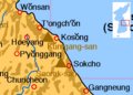
Location of Kumgangsan
- Gumgang2.jpg
High elevation cliffs on Kumgangsan
Kumgangsan rock formations
A view of Kŭmgangsan from the coast at Sea Kŭmgang
Kuryong (Nine Dragons) Waterfall
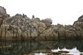
A view of Sea Kumgang from the sea.
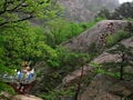
The path to Nine Dragons Waterfall
Nine Dragons Waterfall from japanese article
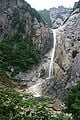
Nine Dragons Waterfall on Kŭmgangsan
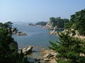
A view of Sea Kumgang.
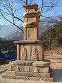
Late Silla period pagoda on the grounds of Kumgansan's Shingyesa Temple. The rest of the temple was destoryed by fire during the Korea War.
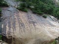
Poem by Kim Il Sung praising his son Kim Jong Il, on Kim Jong Il’s 50th birthday. Written in Hanja, and again in Hangul on the right.


See also
- List of Korea-related topics
- List of mountains in Korea
- Geography of North Korea
Notes
External links
- Mt. Kumgang Tour. Retrieved November 9, 2007. Tel+82-2-739-1090, organizes tours from South Korea to Kumgangsan.
- Hyundae Asan's North Korea tour department. Tel. +82-2-3669-3000, the company behind the tours; some information in English. Retrieved November 9, 2007.
GOnSEE, official travel agency handling international visitors to Kǔmgangsan. Retrieved November 9, 2007.
- Travel guide to Kumgangsan from Wikitravel
Credits
New World Encyclopedia writers and editors rewrote and completed the Wikipedia article in accordance with New World Encyclopedia standards. This article abides by terms of the Creative Commons CC-by-sa 3.0 License (CC-by-sa), which may be used and disseminated with proper attribution. Credit is due under the terms of this license that can reference both the New World Encyclopedia contributors and the selfless volunteer contributors of the Wikimedia Foundation. To cite this article click here for a list of acceptable citing formats.The history of earlier contributions by wikipedians is accessible to researchers here:
The history of this article since it was imported to New World Encyclopedia:
Note: Some restrictions may apply to use of individual images which are separately licensed.