Difference between revisions of "Ha Long Bay" - New World Encyclopedia
Dan Davies (talk | contribs) (help tag|images) |
|||
| (48 intermediate revisions by 5 users not shown) | |||
| Line 1: | Line 1: | ||
| − | + | {{Copyedited}}{{approved}}{{submitted}}{{ready}}{{images OK}} | |
| − | {{ | ||
{{Infobox World Heritage Site | {{Infobox World Heritage Site | ||
| − | |Name | + | |Name = Hạ Long Bay|infoboxwidth= 250px |
| − | |Image | + | |Image = [[Image:FishingVillage HaLongBay Vietnam (pixinn.net).jpg|Floating fishing village|200px]] |
|State_Party = {{VIE}} | |State_Party = {{VIE}} | ||
| − | |Type | + | |Type = Natural |
| − | |Criteria | + | |Criteria = vii, viii |
| − | |ID | + | |ID = 672bis |
| − | |Region | + | |Region = [[List of World Heritage Sites in Asia|Southeast Asia]] |
| − | |Year | + | |Year = 1994, 2000 |
| − | |Session | + | |Session = 18th, 24th |
| − | |Link | + | |Link = http://whc.unesco.org/pg.cfm?cid=31&id_site=672 |
}} | }} | ||
| + | '''Ha Long Bay''' ([[Vietnamese language|Vietnamese]]: ''Vịnh Hạ Long'') situates in [[Quang Ninh|Quảng Ninh province]] | ||
| + | in northeastern Vietnam, from E106°56' to E107°37' and from N20°43' to N21°09'. The bay stretches from Yên Hưng district, past [[Ha Long|Hạ Long city]], [[Cẩm Phả]] town to [[Vân Đồn]] district, bordered on the south and southeast by the [[Gulf of Tonkin]], on the north by [[China]] and on the west and southwest by [[Cat Ba Island|Cát Bà island]]. The bay has a 120 kilometer long coastline and covers approximately 1,553 square kilometers with 1969 islets. [[UNESCO]] designated Ha Long Bay a World Heritage site in 1994 and extended in 2000.<ref>[http://whc.unesco.org/archive/advisory_body_evaluation/672bis.pdf UNESCO Advisory Body Evaluation] Retrieved June 18, 2008.</ref> The area designated by UNESCO as the [[World Heritage Site|World Natural Heritage Site]] includes 434 km² with 775 islets, the zone defined by Đầu Gỗ island on the west, Ba Hầm lake on the south and Cống Tây island on the east. The protected area extends from the Cái Dăm petrol store to Quang Hanh commune, Cẩm Phả town and the surrounding giants zone. The bay features thousands of [[limestone]] [[karst]]s and isles in various sizes and shapes. | ||
| + | {{toc}} | ||
| + | Vietnam's [[Origin myths|origin myth]] points to Halong Bay as the place where [[Vietnam]] became. The myth represents [[Dragon|dragons]] as the founders of the [[Peninsula|peninsula]] empire, which intervened to save the region, on the behest of the gods, from invading Chinese forces. The [[Mythology|myth]] reveals several things. First, the relationship of [[China-Vietnam relations|Vietnam with China]]. As with other smaller kingdoms in [[Southeast Asia,]] great distances from the power centers of China on the coast in the north, Vietnam could successfully resist China's armies. Second, the origin myth of the dragon reveals the Vietnamese people's confidence that the gods have granted Vietnam a special protection and blessing. Third, the natural beauty and uniqueness of Halong Bay is revealed through the dragon [[Origin myth|origin myth]]. The myth portrays the creation of 1600 islands, shaped in unique forms out of limestone, as the result of the dragons spitting jewels and jade into the sea. Halong Bay has been nominated as one of the [[Eight Wonders of the World|eight wonders]] of the world. | ||
| − | + | == UNESCO Site == | |
| − | + | In 1962, Vietnam Ministry of Culture, Sport and Tourism declared Halong Bay a National Renowned Landscape Vestige site.<ref> Halong Bay Wonder in Vietnam voting campaign launched, Footprint.</ref> [[UNESCO]] listed the bay as a World's Natural Heritage at the 18th meeting of the Committee of the World Heritages of UNESCO (in [[Phuket]], [[Thailand]] on December 17, 1994), citing its exceptional aesthetic nature, as an outstanding natural site. On December 2, 2000 at the 24th meeting of Committee of the World Heritages in [[Cairns]], [[Australia]], UNESCO designated Halong bay a [[World Heritage Site]] for its outstanding geological and geomorphological value according to the criteria of that Convention.<ref>[http://whc.unesco.org/en/list/672 Halong Bay - UNESCO World Heritage Site, UNESCO World Heritage Center] Retrieved June 18, 2008.</ref> The New Open World Foundation nominated Halong bay as one of the World's Eight Natural Wonders, the decision scheduled for August 8, 2008.<ref>[http://www.natural7wonders.com Seven Wonders of the World] Retrieved June 25, 2008.</ref> | |
| − | < | ||
| − | |||
| − | == | + | == Origin Myth== |
| − | + | Local legend relates that when the Vietnamese fought invading Chinese armies, the gods sent a family of dragons to help defend the land.<ref>[http://whc.unesco.org/en/list/672/video View World Heritage Video] Retrieved July 4, 2008.</ref> That family of dragons began spitting out jewels and jade. Those jewels turned into the islands and islets dotting the bay, linking together to form a great wall against the invaders. The people kept their land safe and formed what later became the country of Vietnam. After that, dragons decided to live in Ha Long Bay. The place where Mother Dragon flew down became Hạ Long, the place where the dragon children attended upon their mother received the name [[Bái Tử Long]] island (Bái: attend upon; Tử: children; Long: dragon), and the place where the dragon children wriggled their tails violently became known as Bạch Long Vỹ island (Bạch: white- color of the foam made when Children Dragon wriggle; Long: dragon, Vỹ: tail). | |
| − | |||
| − | |||
| − | |||
== History == | == History == | ||
| − | |||
| − | |||
| − | |||
| − | |||
| − | |||
| − | |||
| − | |||
| − | + | Mê Cung and Thiên Long archaeological sites in Hạ Long and Bái Tử Long provide a look into Halong Bay's prehistoric period. Mounds of the remains of mountain shellfishes ([[Cyclophorus]]) and spring shellfishes ([[Melania]]), some fresh water mollusk and some rudimentary labor tools have been found in the site. The Soi Nhụ tribe inhabited the region before 5000 B.C.E. They lived primarily by catching shellfish and fish, collecting fruits and digging for bulbs and roots. Their way of life compares to other tribes in Vietnam during that period, including the Hoà Bình and Bắc Sơn. The | |
| − | + | Cái Bèo tribe (5000- 3000 B.C.E.), located in Hạ Long and Cát Bà island, developed fishing techniques that including using boats. | |
| − | |||
| − | |||
| − | + | Halong Bay has been the setting for battles against invading navies. In the labyrinth of channels in Bach Dang river near the islands, the Vietnamese army stopped the Chinese from landing on three occasions. In 1288, General [[Tran Hung Dao]] stopped [[Mongol]] ships from sailing up the Bach Dang River by placing steel-tipped wooden stakes at high tide, sinking the Mongol fleet.<ref>[http://www.halongbay-vietnam.com/halong_bay_overviews.htm Halong Bay] Retrieved June 18, 2008.</ref> During the [[Vietnam War]], the [[United States]] [[navy]] heavily mined many of the channels between the islands, some still pose a threat to shipping.<ref>[http://www.tripadvisor.com/Travel-g293923-s203/Halong-Bay:Vietnam:History.html Halong Bay History, Trip Advisor.com] Retrieved June 25, 2008.</ref> | |
| − | + | A community of around 1600 people live on Halong bay in four fishing villages: Cửa Vạn, Ba Hang, Cống Tàu and Vông Viêng in Hùng Thắng commune, Hạ Long city. They live on floating houses, sustained by fishing and marine aquaculture (cultivating marine biota). | |
== System of isles and caves == | == System of isles and caves == | ||
| − | |||
[[Image:Thien Cung.jpg|Thien Cung grotto|thumb|right|200px|Thien Cung grotto]] | [[Image:Thien Cung.jpg|Thien Cung grotto|thumb|right|200px|Thien Cung grotto]] | ||
| − | + | Some 1600 [[limestone]] [[island]]s and inlets, covered by jungle vegetation, populate Halong bay. The effect of some many tightly packed, richly vegetated, limestone islands is remarkable. The islands, for the most part, are uninhabitable, the limestone terrain making living too difficult. Enormous caves exist on some the the islands, giving the sense of being hollow.<ref>[http://www.smiletravelvietnam.com/vietnam-travel_Ha-Long_28_travel.aspx Halong Bay, Smile Vietnam Travel.com] Retrieved June 18, 2008.</ref> Hang Đầu Gỗ (Wooden stakes Cave) stands as the largest grotto in the Halong area. | |
| − | |||
| − | |||
| − | |||
| − | |||
| − | |||
| − | |||
| − | + | In the late nineteenth century, French named the cave ''Grotte des Merveilles''. Abundant stalactites and stalagmites furnish the three gigantic chambers. Tuan Chau and [[Cat ba island|Cat Ba]], the two largest islands in the Bay, have year-round residents, along with hotels and beaches. Many of the smaller islands, suitable only for short stays, have idyllic beaches.<ref name=vietnam>[http://www.halongbay-vietnam.com/halong_bay_overviews.htm Halong Bay: A Wonder of the World, halongbay-vietnam.com] Retrieved June 18, 2008.</ref> | |
| − | + | Floating villages, adapting to the inhospitable limestone [[island]]s, have taken root on some islands. They fish the bay for 200 species of [[fish]] and 450 different kinds of [[mollusk]]s.<ref>[http://www.travel84.com/latest-news/public-vote-sought-for-ha-long-bay-as-world-natural-wonder.html Public vote sought for Ha Long Bay as world natural wonder, Travel84.com.] Retrieved June 18, 2008</ref> Islands often receive their names from the images their forms suggest, for example: Voi Islet (elephant), Ga Choi Islet (fighting cock), and Mai Nha Islet (roof). 1000 islands have received names. Although the islands, for the most part, have proven impossible for humans to live year round, birds and animals inhabit them, including [[bantam]]s, [[antelope]]s, [[monkey]]s, and [[iguana]]s.<ref name=vietnam/> | |
| − | + | == Geology, Biodiversity, and Climate == | |
| + | [[Image:The Kissing Cocks-Ha Long Bay-Vietnam.JPG|The Kissing Rocks|thumb|right|250px|The Kissing Rocks]] | ||
| − | + | A thick limestone layer, hot and moist climate, and slow tectonic process worked simultaneous to develop Ha Long bay's [[karst topography]] during the last 20 million years. For the past 500 million years, Halong bay has passed through several geological states of [[orogeny]], [[sea level rise|marine transgression]] and [[marine regression]]. Halong bay had been open, deep sea during the [[Ordovician]] and [[Silurian]] periods (500-410 million years ago), becoming a shallow sea during the [[Carboniferous]] and [[Permian]] periods (340-250 million years ago). | |
| − | |||
| − | |||
| − | |||
| − | |||
| − | |||
| − | Halong bay | + | Ha Long Bay hosts two [[ecosystem]]s: a tropical, moist, evergreen rain forest ecosystem and a marine and coastal ecosystem. [[Temperature]] ranges between from 15°C- 25°C. Annual [[rainfall]] measures 2000 mm and 2200 mm. Halong bay has the typical diurnal [[tide]] system (tide amplitude ranges from 3.5-4 m). The [[salinity]] measures from 31 to 34.5 MT in dry season and lower in rainy season. |
| − | + | The bay is home to seven endemic species. The include [[Livistona halongensis]], [[Impatiens halongensis]], [[Chirieta halongensis]], [[Chirieta hiepii]], [[Chirieta modesta]], [[Paraboea halongensis]], and [[Alpinia calcicola]]. The many islands that dot the bay serve as home to a great many other species, including (but likely not limited to): 477 [[magnoliales]], 12 [[pteris]], 20 [[salt marsh]] flora and four [[amphibia]], ten [[reptilia]], 40 [[aves]], and four [[mammalia]]. | |
| − | |||
| − | |||
| − | |||
| − | |||
| − | |||
| − | |||
| − | |||
| − | |||
| − | |||
| − | |||
| − | |||
| − | |||
| − | |||
| − | |||
| − | |||
| − | |||
| − | |||
| − | |||
| − | |||
| − | |||
| − | |||
| − | |||
| − | |||
| − | |||
| − | The many islands that dot the bay | ||
| − | |||
| − | |||
| − | |||
| − | |||
| − | |||
| − | |||
| − | |||
| − | |||
| − | |||
| − | |||
| − | |||
| − | |||
| − | |||
| − | |||
| − | |||
| − | |||
| − | |||
| − | |||
| − | |||
| − | |||
| − | |||
| − | |||
| − | |||
| − | |||
| − | |||
| − | |||
| − | |||
| − | |||
| − | |||
| − | |||
| − | |||
| − | |||
| − | |||
== Gallery == | == Gallery == | ||
| − | <gallery> | + | <center><gallery> |
Image:IMG_0014-1.jpg|Ha Long Bay View, April 26 2007 | Image:IMG_0014-1.jpg|Ha Long Bay View, April 26 2007 | ||
Image:IMG_0122-1.jpg|Ha Long Bay, April 26 2007 | Image:IMG_0122-1.jpg|Ha Long Bay, April 26 2007 | ||
| − | |||
Image:Ha Long Bay.jpg|Ha Long Bay | Image:Ha Long Bay.jpg|Ha Long Bay | ||
| − | |||
| − | |||
| − | |||
Image:Ha long bay.jpg|Ha Long Bay | Image:Ha long bay.jpg|Ha Long Bay | ||
| − | </gallery> | + | </gallery></center> |
==See also== | ==See also== | ||
| Line 148: | Line 64: | ||
==Notes== | ==Notes== | ||
<references/> | <references/> | ||
| + | |||
| + | ==References== | ||
| + | * Bowermaster, Jon. ''Descending the dragon: my adventures along the coast of Vietnam''. Washington, DC: National Geographic Society, 2008. ISBN 978-1426203046 | ||
| + | * Dõ̂ Phương Quỳnh. ''Ha Long Bay and Quang Ninh Province: the face of Vietnam''. Hanoi: GIOI, 1994. {{OCLC|221981510}} | ||
| + | * Downs, Tom. ''Hanoi & Halong Bay''. Footscray, Vic: Lonely Planet, 2007. ISBN 978-1741790924 | ||
| + | * Hill, L., and B. Wald. Scaling the Dragon's Spires: Drawn by natural arches and sheer cliffs, sport climbers tackle the Ha Long Bay islands of Vietnam. ''NATIONAL GEOGRAPHIC''. 192 (6) (1997): 110-119. {{OCLC|202484645}} | ||
==External links== | ==External links== | ||
| − | + | All links retrieved July 22, 2017. | |
| − | *[http:// | + | |
| − | *[http://www. | + | *[http://whc.unesco.org/en/list/672 Halong Bay - UNESCO World Heritage Site. UNESCO World Heritage Center] |
| + | *[http://www.terragalleria.com/vietnam/vietnam.halong.html Halong Bay, Pictures by QT Luong. terragalleria.com] | ||
Latest revision as of 23:30, 29 July 2023
| Hạ Long Bay* | |
|---|---|
| UNESCO World Heritage Site | |
.jpg)
| |
| Type | Natural |
| Criteria | vii, viii |
| Reference | 672bis |
| Region** | Southeast Asia |
| Inscription history | |
| Inscription | 1994, 2000 (18th, 24th Session) |
| * Name as inscribed on World Heritage List. ** Region as classified by UNESCO. | |
Ha Long Bay (Vietnamese: Vịnh Hạ Long) situates in Quảng Ninh province in northeastern Vietnam, from E106°56' to E107°37' and from N20°43' to N21°09'. The bay stretches from Yên Hưng district, past Hạ Long city, Cẩm Phả town to Vân Đồn district, bordered on the south and southeast by the Gulf of Tonkin, on the north by China and on the west and southwest by Cát Bà island. The bay has a 120 kilometer long coastline and covers approximately 1,553 square kilometers with 1969 islets. UNESCO designated Ha Long Bay a World Heritage site in 1994 and extended in 2000.[1] The area designated by UNESCO as the World Natural Heritage Site includes 434 km² with 775 islets, the zone defined by Đầu Gỗ island on the west, Ba Hầm lake on the south and Cống Tây island on the east. The protected area extends from the Cái Dăm petrol store to Quang Hanh commune, Cẩm Phả town and the surrounding giants zone. The bay features thousands of limestone karsts and isles in various sizes and shapes.
Vietnam's origin myth points to Halong Bay as the place where Vietnam became. The myth represents dragons as the founders of the peninsula empire, which intervened to save the region, on the behest of the gods, from invading Chinese forces. The myth reveals several things. First, the relationship of Vietnam with China. As with other smaller kingdoms in Southeast Asia, great distances from the power centers of China on the coast in the north, Vietnam could successfully resist China's armies. Second, the origin myth of the dragon reveals the Vietnamese people's confidence that the gods have granted Vietnam a special protection and blessing. Third, the natural beauty and uniqueness of Halong Bay is revealed through the dragon origin myth. The myth portrays the creation of 1600 islands, shaped in unique forms out of limestone, as the result of the dragons spitting jewels and jade into the sea. Halong Bay has been nominated as one of the eight wonders of the world.
UNESCO Site
In 1962, Vietnam Ministry of Culture, Sport and Tourism declared Halong Bay a National Renowned Landscape Vestige site.[2] UNESCO listed the bay as a World's Natural Heritage at the 18th meeting of the Committee of the World Heritages of UNESCO (in Phuket, Thailand on December 17, 1994), citing its exceptional aesthetic nature, as an outstanding natural site. On December 2, 2000 at the 24th meeting of Committee of the World Heritages in Cairns, Australia, UNESCO designated Halong bay a World Heritage Site for its outstanding geological and geomorphological value according to the criteria of that Convention.[3] The New Open World Foundation nominated Halong bay as one of the World's Eight Natural Wonders, the decision scheduled for August 8, 2008.[4]
Origin Myth
Local legend relates that when the Vietnamese fought invading Chinese armies, the gods sent a family of dragons to help defend the land.[5] That family of dragons began spitting out jewels and jade. Those jewels turned into the islands and islets dotting the bay, linking together to form a great wall against the invaders. The people kept their land safe and formed what later became the country of Vietnam. After that, dragons decided to live in Ha Long Bay. The place where Mother Dragon flew down became Hạ Long, the place where the dragon children attended upon their mother received the name Bái Tử Long island (Bái: attend upon; Tử: children; Long: dragon), and the place where the dragon children wriggled their tails violently became known as Bạch Long Vỹ island (Bạch: white- color of the foam made when Children Dragon wriggle; Long: dragon, Vỹ: tail).
History
Mê Cung and Thiên Long archaeological sites in Hạ Long and Bái Tử Long provide a look into Halong Bay's prehistoric period. Mounds of the remains of mountain shellfishes (Cyclophorus) and spring shellfishes (Melania), some fresh water mollusk and some rudimentary labor tools have been found in the site. The Soi Nhụ tribe inhabited the region before 5000 B.C.E. They lived primarily by catching shellfish and fish, collecting fruits and digging for bulbs and roots. Their way of life compares to other tribes in Vietnam during that period, including the Hoà Bình and Bắc Sơn. The Cái Bèo tribe (5000- 3000 B.C.E.), located in Hạ Long and Cát Bà island, developed fishing techniques that including using boats.
Halong Bay has been the setting for battles against invading navies. In the labyrinth of channels in Bach Dang river near the islands, the Vietnamese army stopped the Chinese from landing on three occasions. In 1288, General Tran Hung Dao stopped Mongol ships from sailing up the Bach Dang River by placing steel-tipped wooden stakes at high tide, sinking the Mongol fleet.[6] During the Vietnam War, the United States navy heavily mined many of the channels between the islands, some still pose a threat to shipping.[7]
A community of around 1600 people live on Halong bay in four fishing villages: Cửa Vạn, Ba Hang, Cống Tàu and Vông Viêng in Hùng Thắng commune, Hạ Long city. They live on floating houses, sustained by fishing and marine aquaculture (cultivating marine biota).
System of isles and caves

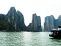
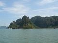
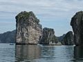
Some 1600 limestone islands and inlets, covered by jungle vegetation, populate Halong bay. The effect of some many tightly packed, richly vegetated, limestone islands is remarkable. The islands, for the most part, are uninhabitable, the limestone terrain making living too difficult. Enormous caves exist on some the the islands, giving the sense of being hollow.[8] Hang Đầu Gỗ (Wooden stakes Cave) stands as the largest grotto in the Halong area.
In the late nineteenth century, French named the cave Grotte des Merveilles. Abundant stalactites and stalagmites furnish the three gigantic chambers. Tuan Chau and Cat Ba, the two largest islands in the Bay, have year-round residents, along with hotels and beaches. Many of the smaller islands, suitable only for short stays, have idyllic beaches.[9]
Floating villages, adapting to the inhospitable limestone islands, have taken root on some islands. They fish the bay for 200 species of fish and 450 different kinds of mollusks.[10] Islands often receive their names from the images their forms suggest, for example: Voi Islet (elephant), Ga Choi Islet (fighting cock), and Mai Nha Islet (roof). 1000 islands have received names. Although the islands, for the most part, have proven impossible for humans to live year round, birds and animals inhabit them, including bantams, antelopes, monkeys, and iguanas.[9]
Geology, Biodiversity, and Climate

A thick limestone layer, hot and moist climate, and slow tectonic process worked simultaneous to develop Ha Long bay's karst topography during the last 20 million years. For the past 500 million years, Halong bay has passed through several geological states of orogeny, marine transgression and marine regression. Halong bay had been open, deep sea during the Ordovician and Silurian periods (500-410 million years ago), becoming a shallow sea during the Carboniferous and Permian periods (340-250 million years ago).
Ha Long Bay hosts two ecosystems: a tropical, moist, evergreen rain forest ecosystem and a marine and coastal ecosystem. Temperature ranges between from 15°C- 25°C. Annual rainfall measures 2000 mm and 2200 mm. Halong bay has the typical diurnal tide system (tide amplitude ranges from 3.5-4 m). The salinity measures from 31 to 34.5 MT in dry season and lower in rainy season.
The bay is home to seven endemic species. The include Livistona halongensis, Impatiens halongensis, Chirieta halongensis, Chirieta hiepii, Chirieta modesta, Paraboea halongensis, and Alpinia calcicola. The many islands that dot the bay serve as home to a great many other species, including (but likely not limited to): 477 magnoliales, 12 pteris, 20 salt marsh flora and four amphibia, ten reptilia, 40 aves, and four mammalia.
Gallery
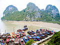
Ha Long Bay View, April 26 2007
Ha Long Bay, April 26 2007
Ha Long Bay
Ha Long Bay


See also
- Ha Long
Notes
- ↑ UNESCO Advisory Body Evaluation Retrieved June 18, 2008.
- ↑ Halong Bay Wonder in Vietnam voting campaign launched, Footprint.
- ↑ Halong Bay - UNESCO World Heritage Site, UNESCO World Heritage Center Retrieved June 18, 2008.
- ↑ Seven Wonders of the World Retrieved June 25, 2008.
- ↑ View World Heritage Video Retrieved July 4, 2008.
- ↑ Halong Bay Retrieved June 18, 2008.
- ↑ Halong Bay History, Trip Advisor.com Retrieved June 25, 2008.
- ↑ Halong Bay, Smile Vietnam Travel.com Retrieved June 18, 2008.
- ↑ 9.0 9.1 Halong Bay: A Wonder of the World, halongbay-vietnam.com Retrieved June 18, 2008.
- ↑ Public vote sought for Ha Long Bay as world natural wonder, Travel84.com. Retrieved June 18, 2008
ReferencesISBN links support NWE through referral fees
- Bowermaster, Jon. Descending the dragon: my adventures along the coast of Vietnam. Washington, DC: National Geographic Society, 2008. ISBN 978-1426203046
- Dõ̂ Phương Quỳnh. Ha Long Bay and Quang Ninh Province: the face of Vietnam. Hanoi: GIOI, 1994. OCLC 221981510
- Downs, Tom. Hanoi & Halong Bay. Footscray, Vic: Lonely Planet, 2007. ISBN 978-1741790924
- Hill, L., and B. Wald. Scaling the Dragon's Spires: Drawn by natural arches and sheer cliffs, sport climbers tackle the Ha Long Bay islands of Vietnam. NATIONAL GEOGRAPHIC. 192 (6) (1997): 110-119. OCLC 202484645
External links
All links retrieved July 22, 2017.
- Halong Bay - UNESCO World Heritage Site. UNESCO World Heritage Center
- Halong Bay, Pictures by QT Luong. terragalleria.com
| ||||||||||
Credits
New World Encyclopedia writers and editors rewrote and completed the Wikipedia article in accordance with New World Encyclopedia standards. This article abides by terms of the Creative Commons CC-by-sa 3.0 License (CC-by-sa), which may be used and disseminated with proper attribution. Credit is due under the terms of this license that can reference both the New World Encyclopedia contributors and the selfless volunteer contributors of the Wikimedia Foundation. To cite this article click here for a list of acceptable citing formats.The history of earlier contributions by wikipedians is accessible to researchers here:
The history of this article since it was imported to New World Encyclopedia:
Note: Some restrictions may apply to use of individual images which are separately licensed.