Difference between revisions of "Arabian Sea" - New World Encyclopedia
({{Contracted}}) |
Mary Anglin (talk | contribs) |
||
| Line 1: | Line 1: | ||
| − | {{claimed}}{{Contracted}} | + | {{claimed}}{{Contracted}}{{Images OK}} |
{| style="float:right" | {| style="float:right" | ||
| | | | ||
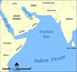
[[Image:Arabian Sea map.png|thumb|right|Map of the Arabian Sea.]] | [[Image:Arabian Sea map.png|thumb|right|Map of the Arabian Sea.]] | ||
| − | |||
|} | |} | ||
| Line 9: | Line 8: | ||
==Description== | ==Description== | ||
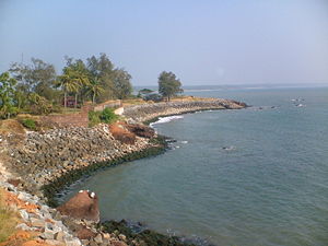
| + | [[Image:Kannurfort1.JPG|thumb|300px|A view of Arabian Sea from [[St. Angelo's Fort]] in [[Kannur District]] of [[Kerala]], [[south India]].]] | ||
| + | [[Image:100 0819.jpg|thumb|300px|[[Surathkal]] beach on shore of Arabian sea]] | ||
And it was known as the ''Sindhu Sagar'' to Indians in the [[Vedic period]] of their history, and an important [[marine]] [[trade route]] in the era of the ''coastal sailing vessels'' from possibly as early as the [[3rd millennium B.C.E.]], certainly the late [[2nd millennium B.C.E.]] through the latter days known as the [[Age of Sail]]. By the time of [[Julius Caesar]], several well-established combined land-sea trade routes depended upon [[water transport]] through the Sea around the rough inland [[terrain feature]]s to its north. | And it was known as the ''Sindhu Sagar'' to Indians in the [[Vedic period]] of their history, and an important [[marine]] [[trade route]] in the era of the ''coastal sailing vessels'' from possibly as early as the [[3rd millennium B.C.E.]], certainly the late [[2nd millennium B.C.E.]] through the latter days known as the [[Age of Sail]]. By the time of [[Julius Caesar]], several well-established combined land-sea trade routes depended upon [[water transport]] through the Sea around the rough inland [[terrain feature]]s to its north. | ||
| Line 20: | Line 21: | ||
==Trade routes== | ==Trade routes== | ||
| − | |||
Ocean trade routes have crossed the Arabian Sea since ancient times, linking the [[Near East]] with [[East Africa]], [[India]], [[Southeast Asia]], and [[China]]. Historically, sailors in a type of ship called a [[dhow]] used the seasonal [[monsoon]] winds to cross the water. The sea forms part of the chief shipping route between [[Europe]] and India via the [[Suez Canal]], which links the [[Red Sea]] with the [[Mediterranean Sea]]. | Ocean trade routes have crossed the Arabian Sea since ancient times, linking the [[Near East]] with [[East Africa]], [[India]], [[Southeast Asia]], and [[China]]. Historically, sailors in a type of ship called a [[dhow]] used the seasonal [[monsoon]] winds to cross the water. The sea forms part of the chief shipping route between [[Europe]] and India via the [[Suez Canal]], which links the [[Red Sea]] with the [[Mediterranean Sea]]. | ||
Revision as of 16:39, 6 November 2007
The Arabian Sea is a region of the Indian Ocean bounded on the east by India, on the north by Pakistan and Iran, on the west by Arabian Peninsula, on the south, approximately, by a line between Cape Guardafui, the north-east point of Somalia, Socotra and Kanyakumari (Cape Comorin) in India.
Description

And it was known as the Sindhu Sagar to Indians in the Vedic period of their history, and an important marine trade route in the era of the coastal sailing vessels from possibly as early as the 3rd millennium B.C.E., certainly the late 2nd millennium B.C.E. through the latter days known as the Age of Sail. By the time of Julius Caesar, several well-established combined land-sea trade routes depended upon water transport through the Sea around the rough inland terrain features to its north.
These routes usually began in the Far East or down river from Madhya Pradesh with transshipment via historic Bharuch (Bharakuccha), traversed past the inhospitable coast of today's Iran then split around Hadhramaut into two streams north into the Gulf of Aden and thence into the Levant, or south into Alexandria via Red Sea ports such as Axum. Each major route involved transshipping to pack animal caravan, travel through desert country and risk of bandits and extortionary tolls by local potentiates. These are the reality of the conditions which gave rise to the truth behind the tales of the Arabian Nights stories, and those of Sinbad the Sailor.
So important was this southern coastal route past the rough country in the southern Arabian peninsula (Yemen and Oman today), that the Egyptian Pharaohs built several shallow canals to service the trade, one more or less along the route of today's Suez canal, and another from the Red Sea to the Nile River, both shallow works that were swallowed up by huge sand storms in antiquity. Later the kingdom of Axum arose in Ethiopia to rule a mercantile empire rooted in the trade with Europe via Alexandria.
It has two important branches — the Gulf of Aden in the southwest, connecting with the Red Sea through the strait of Bab-el-Mandeb; and the Gulf of Oman to the northwest, connecting with the Persian Gulf. Besides these larger ramifications, there are the gulfs of Cambay and Kutch on the Indian coast. Its islands are few, the chief being Socotra, off the African, and the Laccadives, off the Indian coast.
The maximum width of the Arabian Sea is approximately 2,400 km, and its maximum depth is 4,652 metres, in the Arabian Basin approximately at the same latitude as the southernmost tip of India. The Indus River, also known as the Sindhu river, is the largest river flowing directly into this sea; others include the Netravathi, Sharavathi, Narmada, Tapti, Mahi, and the numerous rivers of Kerala in India. The Arabian Sea coast of central India is known as the Konkan Coast, and that of southern India is known as the Malabar Coast.
Trade routes
Ocean trade routes have crossed the Arabian Sea since ancient times, linking the Near East with East Africa, India, Southeast Asia, and China. Historically, sailors in a type of ship called a dhow used the seasonal monsoon winds to cross the water. The sea forms part of the chief shipping route between Europe and India via the Suez Canal, which links the Red Sea with the Mediterranean Sea.
The countries with coastlines on the Arabian Sea are India, Yemen, Oman, Iran, Pakistan, Sri Lanka, the Maldives, and Somalia.
Cities on the coast include Mumbai (Bombay), Ratnagiri, Surat, Goa, Mangalore, and Kochi in India, Karachi and Gwadar in Pakistan, Aden and Mukalla in Yemen, Salalah in Oman
Notes
Sources and further reading
This article incorporates text from the Encyclopædia Britannica Eleventh Edition, a publication now in the public domain.
External links
| |||||||||||
Credits
New World Encyclopedia writers and editors rewrote and completed the Wikipedia article in accordance with New World Encyclopedia standards. This article abides by terms of the Creative Commons CC-by-sa 3.0 License (CC-by-sa), which may be used and disseminated with proper attribution. Credit is due under the terms of this license that can reference both the New World Encyclopedia contributors and the selfless volunteer contributors of the Wikimedia Foundation. To cite this article click here for a list of acceptable citing formats.The history of earlier contributions by wikipedians is accessible to researchers here:
The history of this article since it was imported to New World Encyclopedia:
Note: Some restrictions may apply to use of individual images which are separately licensed.
