Abuja
| Abuja, Nigeria | |
| Abuja, Nigeria. | |
| Phase I and II represents Abuja city on a map of FCT | |
| Coordinates: | |
|---|---|
| Territory | Federal Capital Territory |
| Government | |
| - Minister | Aliyu Modibbo Umar |
| Area | |
| - Total | 713 km² (275.3 sq mi) |
| - Land | 713 km² (275.3 sq mi) |
| Population (2006) | |
| - Total | 778,567 [1] |
| Time zone | WAT (UTC+1) |
| Website: http://www.fct.gov.ng/ | |
Abuja, officially Abuja Municipal Area Council, is the capital city of Nigeria, and is known as the best planned city in Africa as well as one of the wealthiest and most expensive. Abuja was mainly built in the 1980s and officially became Nigeria's capital on December 12, 1991, replacing the role of the previous capital Lagos.
Geography
The word "Abuja" refers to both a federal capital territory within the nation of Nigeria and a city within that territory, both created in 1976.
Federal Capital Territory
The territory is north of the confluence of the Niger and Benue Rivers. Bordering the FCT are the states of Kaduna to the northeast, Plateau to the east and south, Kogi to the southwest, and Niger to the west and northwest. It is slightly west of the center of the country. The territory's vegetation has limited forest surrounded by savanna. Its mineral resources include clay, feldspar, gold, iron ore, lead, marble, talc, and tin. Its area covers 2,824 square miles (7,315 square km).
Abuja's geography, and very character, is defined by two renowned rock formations around it—the Zuma Rock and the Aso Rock. The Zuma Rock is called the "Gateway to Abuja" as the Federal Capital Territory begins at its base. The Aso Rock, a 400-meter monolith left by water erosion, is located at the head of Abuja city, which extends southward from the rock.
Abuja has a cooler climate and less humidity than is found in Lagos. There are three seasons, including a warm, humid rainy season, from April to October, and a blistering dry season, when daytime temperatures can soar as high as 40 degrees celsius (104 degrees fahrenheit). Between these seasons is a brief interlude of harmattan occasioned by the north-east trade wind, with characteristic dust haze, intensified coldness and dryness. The high altitudes and undulating terrain of the territory act as moderating influence on the weather of the territory. Rainfall in the FCT reflects the territory's location on the windward side of the Jos Plateau and the zone of rising air masses. The annual total rainfall is in the range of 43.3 inches (1100mm) to 63 inches (1600mm).
City
Abuja, a planned modern city, is located near the center of the territory, approximately 300 miles (480km) northeast of Lagos, the country's largest city and former capital. The city is 1180 feet (360 meters) above sea level. The city has several parks and green areas with the largest being Millennium Park, which was designed by renowned architect Manfredi Nicoletti and was officially opened by Queen Elizabeth II of England.
Magnificent buildings abound in Abuja. There is the National Mosque with its golden dome glistening in the sun, the bright pink Federal Secretariat Complex, and the Nigerian National Christian Centre. Other landmarks include the Central Bank of Nigeria headquarters, NNPC towers, Abuja International Conference Centre African Hall, Gurara Falls, Eagle Square, the National Assembly building, Abuja Stadium, the Velodrome, among others. However, people on the semi-developed edges of the city live in shanty towns such as Karu, which was built to house the capital's civil servants and lower income families. Karu had no running water, sanitation or electricity in 2008.
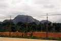
Aso Rock
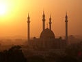
Abuja National Mosque during Harmattan
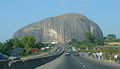
Zuma Rock
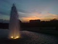
Abuja Millenium Park


History

Since Nigeria's independence from the United Kingdom on October 1, 1960, ethnic and religious divisions required the creation of a capital city in a location deemed neutral to all parties. Also, Lagos's population boom made that city overcrowded and conditions squalid. The site for a new capital was chosen because of its central location, easy accessibility, pleasant climate, low population density, and the availability of land for future expansion.
A consortium of three American firms: PRC Corporation; Wallace, McHarg, Roberts and Todd; and, Archisystems, created a master plan for Abuja. Renowned Japanese architect Kenzo Tange refined the design. Construction began in the late 1970s, but economic and political instability meant the city’s initial stages were not complete until the late 1980s.
Most countries moved their embassies to Abuja while maintaining their larger former embassies as consulates in the commercial capital, Lagos.
Administration
The Federal Capital Territory is a component of the 36 states and one territory that make up the Federal Republic of Nigeria's administrative system. Abuja is the location of the Presidential Complex, National Assembly, and the Supreme Court, and houses the headquarters of the Economic Community of West African States (ECOWAS), as well as its military arm, ECOMOG. It also has the regional headquarters of OPEC.
The city’s phase one districts are: Abuja Central, which is the city's principal business zone and includes the National Assembly, the city hall, national cultural institutes, and other government-related offices, Garki, Wuse, Maitama, which is exclusive and is the location of European embassies, and Asokoro. Phase two districts are: Kado, Durumi, Gudu, Utako and Jabi. Phase three districts are: Mabuchi, Katampe, Wuye and Gwarimpa. There are also five suburban districts, which are Nyanya, Karu, Gwagwalada, Kubwa, and Jukwoyi.
Along the airport road are clusters of satellite settlements: Lugbe, Chika, Kuchigworo and Pyakassa. Other satellite settlements are Idu (The Main Industrial Zone), Mpape, Karimu, Gwagwa, Dei-Dei (housing the International Livestock market and also International Building materials market).
Economy

Abuja's Nnamdi Azikiwe International Airport, named after Nigeria's first president, consists of an international and a domestic terminal, both sharing the same runway. In 2004, the airport served 2,232,905 passengers. Abuja city has major road connections, and has an efficient rapid bus and green cab system. Construction was underway, in 2008, for a light rail system for the city. Abuja did not (2008) have a connection to the national railway network of Nigeria. Agriculture in the area produces yams, millet, maize, sorghum, and beans. Mineral resources include clay, tin, feldspar, gold, iron ore, lead, marble, and talc.
Demographics

The Federal Capital Territory had a population of 778,567 in 2006. Both the city and the Federal Capital Territory have undergone a huge population growth—with some areas around Abuja growing at a rate of up to 30 percent each year.
Abuja was planned as a capital where all Nigeria's ethnic groups, tribes and religions would come together in harmony. It has avoided the violence prevalent in other parts of Nigeria, which has more than 250 ethnic groups. The population in the Federal Capital Territory include the Afo, Fulani, Gwari, Hausa, Koro, Ganagana, Gwandara, and Bassa ethnic groups.
English is the official language. Other languages spoken in the territory include Hausa, Yoruba, Ibo, and Fulani. Muslims make up 50 percent of the population, Christians 40 percent, while the remainder adhere to indigenous beliefs.
ReferencesISBN links support NWE through referral fees
- Abumere SI. 1984. The future population of the Federal Capital Territory, Abuja. The Nigerian Journal of Economic and Social Studies. 26 (3): 287-313. ISSN 0029-0092
- AfricanCities.net. Abuja Retrieved June 22, 2008.
- Elleh, Nnamdi. 2001. Abuja: the single most ambitious urban design project of the 20th century. Architektur der Welt, 5. Weimar: VDG, Verlag und Datenbank für Geisteswissenschaften. ISBN 9783897391659
External links
- Nigerian Road Trip: Abuja BBC News, accessed June 12, 2008.
- Nigeria's Federal Capital Territory website Accessed June 13, 2008
- Abuja.Net African Cities, accessed June 13, 2008.
- Pictures of Abuja Accessed June 13, 2008.
- Abujacity.com Accessed June 13, 2008.
Credits
New World Encyclopedia writers and editors rewrote and completed the Wikipedia article in accordance with New World Encyclopedia standards. This article abides by terms of the Creative Commons CC-by-sa 3.0 License (CC-by-sa), which may be used and disseminated with proper attribution. Credit is due under the terms of this license that can reference both the New World Encyclopedia contributors and the selfless volunteer contributors of the Wikimedia Foundation. To cite this article click here for a list of acceptable citing formats.The history of earlier contributions by wikipedians is accessible to researchers here:
The history of this article since it was imported to New World Encyclopedia:
Note: Some restrictions may apply to use of individual images which are separately licensed.