Difference between revisions of "Bridgetown" - New World Encyclopedia
Mike Butler (talk | contribs) |
Mike Butler (talk | contribs) |
||
| Line 114: | Line 114: | ||
==Geography== | ==Geography== | ||
[[Image:Bridgetown2.jpg|thumb|left|250px|Suburbs of Bridgetown with the harbour in the background]] | [[Image:Bridgetown2.jpg|thumb|left|250px|Suburbs of Bridgetown with the harbour in the background]] | ||
| − | Bridgetown is located on a built-up coastal strip that stretches for several miles | + | Bridgetown is located on a built-up southwestern coastal strip that stretches for several miles. The city's centre was originally a [[swamp]]. |
| − | Barbados has a tropical climate, with mostly sunny and fair weather. Temperatures in January range from 69.8°F (21°C) to 82.4°F (28°C), and in July from 73.4°F (23°C) to 86°F (30°C). | + | Barbados has a tropical climate, with mostly sunny and fair weather. Temperatures in January range from 69.8°F (21°C) to 82.4°F (28°C), and in July from 73.4°F (23°C) to 86°F (30°C). Prevailing cool northeast tradewinds moderate the heat. The dry season occurs from January to June, and the hurricane season extends from June to October, although hurricanes usually miss Barbados. Instead, there are spectacular tropical rainstorms, which are short, heavy, and dry up quickly. Total mean annual rainfall is 32.6 inches (829.8mm). |
The Constitution River draining the west coast lies about a half kilometer south of Bridgetown port. The Careenage, which has an obsolete dry dock and wharves, provides anchorage for pleasure craft or fishing boats, and has two main bridges near the city center. | The Constitution River draining the west coast lies about a half kilometer south of Bridgetown port. The Careenage, which has an obsolete dry dock and wharves, provides anchorage for pleasure craft or fishing boats, and has two main bridges near the city center. | ||
| Line 122: | Line 122: | ||
The city of Bridgetown, and the wider Greater Bridgetown area, cover around 15 square miles (39 square kilometers). The Central Bank, Treasury Building, and National Insurance Building dominate the skyline. | The city of Bridgetown, and the wider Greater Bridgetown area, cover around 15 square miles (39 square kilometers). The Central Bank, Treasury Building, and National Insurance Building dominate the skyline. | ||
| − | The main street is Broad St, which runs, parallel to the Careenage, directly through the centre of the city, past the Parliament Buildings, and is clustered with stores, restaurants, banks, and other services. Bay St is another | + | The main street is Broad St, which runs, parallel to the Careenage, directly through the centre of the city, past the Parliament Buildings, and is clustered with stores, restaurants, banks, and other services. Bay St is another traffic artery into the city. The Spring Garden Highway, which lies to the west of the city, plays host to over 85,000 bystanders and participants in the annual Grand Kadooment Carnival Parade. Ribbon development stretches inland and along the coasts. Numerous businesses have relocated to suburban malls. |
==History== | ==History== | ||
| Line 131: | Line 131: | ||
The earliest inhabitants of Barbados were [[Native American]] nomads migrating toward [[North America]]. The first group, the Salodoid-Barrancoids, arrived by canoe from [[Venezuela]]'s Orinoco Valley around 350 C.E., the second group, the [[Arawak]] people, arrived around 800 C.E., and the third wave, the [[Carib]]s, arrived in the 13th century, displacing both the Arawak and the Salodoid-Barrancoids. | The earliest inhabitants of Barbados were [[Native American]] nomads migrating toward [[North America]]. The first group, the Salodoid-Barrancoids, arrived by canoe from [[Venezuela]]'s Orinoco Valley around 350 C.E., the second group, the [[Arawak]] people, arrived around 800 C.E., and the third wave, the [[Carib]]s, arrived in the 13th century, displacing both the Arawak and the Salodoid-Barrancoids. | ||
| − | [[Portugal|Portuguese]] [[Conquistadors]] seized many Caribs on Barbados and used them as [[Slavery|slave labor]] on [[plantation]]s | + | [[Portugal|Portuguese]] [[Conquistadors]] seized many Caribs on Barbados and used them as [[Slavery|slave labor]] on [[plantation]]s, while other Caribs fled. British sailors who landed on Barbados, at first to collect water in 1620, then permanently in 1625, at the site of present-day Holetown on the Caribbean coast, found the island uninhabited. On July 25, 1628, settlers financed by the Earl of Carlisle established a settlement at the mouth of the Constitution River, to stake a rival claim to that established at Jamestown (Holetown) by colonists representing the Earl of Pembroke. |
| − | + | Although the island was uninhabited when the British landed there, one of the few traces of indigenous pre-existence was a primitive, possibly [[Arawak]], bridge constructed over the Careenage area's swamp. British settlers began to call what is now the Bridgetown area, “the Indian Bridge” or “the Indian Bridgetown”. It was also called St Michael’s town after the parish in which it was situated. Many of the streets of the city date back to their 17th century origins. | |
| − | + | Starting in the 1620s, an increasing number of black slaves were brought to the island. Five thousand locals died of fever in 1647, and hundreds of slaves were executed by [[Cavalier|Royalist]] planters during the [[English Civil War]] (1642-1651), because they feared that the ideas of the [[Levellers]] might spread to the slave population if Parliament took control of Barbados. | |
| − | + | As the [[sugar]] industry developed, Barbados was divided into large plantation estates that replaced the smallholdings of the early British settlers. The Bridgetown port in 1697 exported goods to England valued at some £196,532. Virginia and Maryland were the only colonies to exceed Barbados' trade with an export trade valued at £227,759. | |
| − | Large numbers of Irishmen and Scots were shipped to Barbados as [[indentured servant]]s and slaves. | + | Large numbers of Irishmen and Scots were shipped to Barbados as [[indentured servant]]s and slaves. But increased emigration of Celtic servants and slaves, and increased importation of African slaves, meant Barbados turned from mainly Celtic in the seventeenth century to overwhelmingly black by the nineteenth century. |
| − | + | By 1712, Bridgetown’s population was 10,641, while Boston had 9500, Philadelphia 6500, and New York 5700. Bridgetown’s population included African slaves. A major portion of the slave trade from Africa to the English New World passed through Bridgetown at that time. | |
| − | |||
| − | |||
| − | |||
| − | |||
| − | |||
| − | By 1712, Bridgetown’s population was 10, 641, while Boston had 9500, Philadelphia 6500, and New York 5700. Bridgetown’s population included African slaves. A major portion of the slave trade from Africa to the English New World passed through Bridgetown at that time. | ||
Bridgetown is the only city outside continental North America that [[George Washington]] (1732-1799), the first President of the [[United States]], visited. George Washington House, the actual house where he stayed, is now part of the [[Garrison Historic Area]]. | Bridgetown is the only city outside continental North America that [[George Washington]] (1732-1799), the first President of the [[United States]], visited. George Washington House, the actual house where he stayed, is now part of the [[Garrison Historic Area]]. | ||
| − | The [[slave trade]] ceased in 1804. In 1816, the continuation of slavery caused the largest major slave rebellion in the island's history. One thousand people died in the revolt, with 144 slaves executed and 123 deported. Slavery was abolished in the British Empire 18 years later in 1834. | + | The [[slave trade]] ceased in 1804. In 1816, the continuation of slavery caused the largest major slave rebellion in the island's history. One thousand people died in the revolt, with 144 slaves executed and 123 deported. Slavery was abolished in the British Empire 18 years later in 1834. A cholera epidemic killed about 20,000 people in 1854. |
| − | |||
| − | A cholera epidemic killed about 20,000 people in 1854. | ||
From 1800 until 1885, Bridgetown served as the main seat of Government for the former [[United Kingdom|British]] colonies of the [[Windward Islands]]. During this period, the resident [[Governor of Barbados]] also served as the [[Colonial heads of the Windward Islands|Colonial head of the Windward Islands]]. | From 1800 until 1885, Bridgetown served as the main seat of Government for the former [[United Kingdom|British]] colonies of the [[Windward Islands]]. During this period, the resident [[Governor of Barbados]] also served as the [[Colonial heads of the Windward Islands|Colonial head of the Windward Islands]]. | ||
| − | After the Government of Barbados | + | After the Government of Barbados left the Windward Island union in 1885, the seat was moved from Bridgetown to [[St George's, Grenada|St George's]] on the neighbouring island of [[Grenada]]. |
| − | A high income qualification | + | A high income qualification excluded more than 70 percent of the population from voting. It was not until the 1930s that the descendants of emancipated slaves began a movement for political rights. [[Grantley Adams|Sir Grantley Adams]] (1898-1971), founded the [[Barbados Progressive League]] in 1938, which became the [[Barbados Labour Party]]. In 1942, the exclusive income qualification was lowered and women were given the right to vote. By 1949 governmental control was wrested from the planters and, in 1958, Adams became premier. |
| − | From 1958 to 1962, Barbados was one of the 10 members of the [[West Indies Federation]]. By 1961, [[Errol Walton Barrow]] (1920-1987) had replaced Adams as | + | From 1958 to 1962, Barbados was one of the 10 members of the [[West Indies Federation]]. By 1961, [[Errol Walton Barrow]] (1920-1987) had replaced Adams as premier, and his Democratic Labour Party controlled the government. Barrow served as premier from 1961 until 1966, when Barbados achieved independence from [[Great Britain]]. From 1966, he served continuously as prime minister, as well as doing stints as Minister of Finance, and Minister of Foreign Affairs for the next 10 years. |
| − | In 2004, Bridgetown celebrated its 375th anniversary with a year of events and twinning agreements with | + | In 2004, Bridgetown celebrated its 375th anniversary with a year of events and twinning agreements with Bridgetown, Canada, and with Wilmington, [[United States]]. |
==Government== | ==Government== | ||
Revision as of 21:40, 8 August 2008
| Bridgetown | |
 |
|
 |
|
| Coordinates: | |
|---|---|
| Country | Barbados |
| Parish | Saint Michael |
| Established | 1628 |
| Area | |
| - City | 15.0 sq mi (38.8 km²) |
| Population (2006) | |
| - Metro | 96,578 |
| HDI (2006) | 0.971 – high |
The City of Bridgetown is the capital and largest city of the nation of Barbados. The Bridgetown port is located on the southwestern coast of the island along Carlisle Bay. Established by the British in 1628, Bridgetown is a West Indies tourist destination, and acts as an important financial, informatics and convention centre in the Caribbean region.
Geography

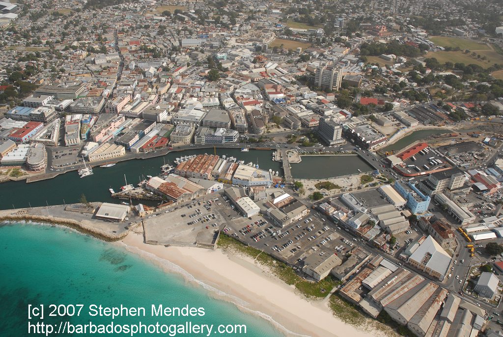
Bridgetown is located on a built-up southwestern coastal strip that stretches for several miles. The city's centre was originally a swamp.
Barbados has a tropical climate, with mostly sunny and fair weather. Temperatures in January range from 69.8°F (21°C) to 82.4°F (28°C), and in July from 73.4°F (23°C) to 86°F (30°C). Prevailing cool northeast tradewinds moderate the heat. The dry season occurs from January to June, and the hurricane season extends from June to October, although hurricanes usually miss Barbados. Instead, there are spectacular tropical rainstorms, which are short, heavy, and dry up quickly. Total mean annual rainfall is 32.6 inches (829.8mm).
The Constitution River draining the west coast lies about a half kilometer south of Bridgetown port. The Careenage, which has an obsolete dry dock and wharves, provides anchorage for pleasure craft or fishing boats, and has two main bridges near the city center.
The city of Bridgetown, and the wider Greater Bridgetown area, cover around 15 square miles (39 square kilometers). The Central Bank, Treasury Building, and National Insurance Building dominate the skyline.
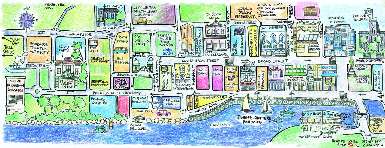
The main street is Broad St, which runs, parallel to the Careenage, directly through the centre of the city, past the Parliament Buildings, and is clustered with stores, restaurants, banks, and other services. Bay St is another traffic artery into the city. The Spring Garden Highway, which lies to the west of the city, plays host to over 85,000 bystanders and participants in the annual Grand Kadooment Carnival Parade. Ribbon development stretches inland and along the coasts. Numerous businesses have relocated to suburban malls.
History


The earliest inhabitants of Barbados were Native American nomads migrating toward North America. The first group, the Salodoid-Barrancoids, arrived by canoe from Venezuela's Orinoco Valley around 350 C.E., the second group, the Arawak people, arrived around 800 C.E., and the third wave, the Caribs, arrived in the 13th century, displacing both the Arawak and the Salodoid-Barrancoids.
Portuguese Conquistadors seized many Caribs on Barbados and used them as slave labor on plantations, while other Caribs fled. British sailors who landed on Barbados, at first to collect water in 1620, then permanently in 1625, at the site of present-day Holetown on the Caribbean coast, found the island uninhabited. On July 25, 1628, settlers financed by the Earl of Carlisle established a settlement at the mouth of the Constitution River, to stake a rival claim to that established at Jamestown (Holetown) by colonists representing the Earl of Pembroke.
Although the island was uninhabited when the British landed there, one of the few traces of indigenous pre-existence was a primitive, possibly Arawak, bridge constructed over the Careenage area's swamp. British settlers began to call what is now the Bridgetown area, “the Indian Bridge” or “the Indian Bridgetown”. It was also called St Michael’s town after the parish in which it was situated. Many of the streets of the city date back to their 17th century origins.
Starting in the 1620s, an increasing number of black slaves were brought to the island. Five thousand locals died of fever in 1647, and hundreds of slaves were executed by Royalist planters during the English Civil War (1642-1651), because they feared that the ideas of the Levellers might spread to the slave population if Parliament took control of Barbados.
As the sugar industry developed, Barbados was divided into large plantation estates that replaced the smallholdings of the early British settlers. The Bridgetown port in 1697 exported goods to England valued at some £196,532. Virginia and Maryland were the only colonies to exceed Barbados' trade with an export trade valued at £227,759.
Large numbers of Irishmen and Scots were shipped to Barbados as indentured servants and slaves. But increased emigration of Celtic servants and slaves, and increased importation of African slaves, meant Barbados turned from mainly Celtic in the seventeenth century to overwhelmingly black by the nineteenth century.
By 1712, Bridgetown’s population was 10,641, while Boston had 9500, Philadelphia 6500, and New York 5700. Bridgetown’s population included African slaves. A major portion of the slave trade from Africa to the English New World passed through Bridgetown at that time.
Bridgetown is the only city outside continental North America that George Washington (1732-1799), the first President of the United States, visited. George Washington House, the actual house where he stayed, is now part of the Garrison Historic Area.
The slave trade ceased in 1804. In 1816, the continuation of slavery caused the largest major slave rebellion in the island's history. One thousand people died in the revolt, with 144 slaves executed and 123 deported. Slavery was abolished in the British Empire 18 years later in 1834. A cholera epidemic killed about 20,000 people in 1854.
From 1800 until 1885, Bridgetown served as the main seat of Government for the former British colonies of the Windward Islands. During this period, the resident Governor of Barbados also served as the Colonial head of the Windward Islands.
After the Government of Barbados left the Windward Island union in 1885, the seat was moved from Bridgetown to St George's on the neighbouring island of Grenada.
A high income qualification excluded more than 70 percent of the population from voting. It was not until the 1930s that the descendants of emancipated slaves began a movement for political rights. Sir Grantley Adams (1898-1971), founded the Barbados Progressive League in 1938, which became the Barbados Labour Party. In 1942, the exclusive income qualification was lowered and women were given the right to vote. By 1949 governmental control was wrested from the planters and, in 1958, Adams became premier.
From 1958 to 1962, Barbados was one of the 10 members of the West Indies Federation. By 1961, Errol Walton Barrow (1920-1987) had replaced Adams as premier, and his Democratic Labour Party controlled the government. Barrow served as premier from 1961 until 1966, when Barbados achieved independence from Great Britain. From 1966, he served continuously as prime minister, as well as doing stints as Minister of Finance, and Minister of Foreign Affairs for the next 10 years.
In 2004, Bridgetown celebrated its 375th anniversary with a year of events and twinning agreements with Bridgetown, Canada, and with Wilmington, United States.
Government

Barbados is a parliamentary democracy within the British Commonwealth. The chief of state Queen Elizabeth II represented by a Governor General. The head of government is the prime minister. The bicameral parliament consists of the Senate, of 21 appointed seats, and the House of Assembly, of 30 members elected by direct popular vote to serve five-year terms.
Formerly, the Town of Saint Michael the city of Bridgetown, and the Greater Bridgetown area occupy most of the parish of Saint Michael. Parts of the Greater Bridgetown area lie along the borders of the neighbouring parishes Christ Church and St. James.
Barbados has been governed by the Barbados Labour Party, commonly called the "Owen Arthur Administration", for 13 years to 2008. Prime Minister Owen S. Arthur was chosen from among leaders around the globe to deliver the William Wilberforce lecture on the 200th Anniversary of the Abolition of the Atlantic Slave Trade.
Economy

Since independence, the island nation of Barbados has transformed itself from a low-income economy dependent upon sugar production, into an upper-middle-income economy based on tourism and the offshore sector. Barbados went into a deep recession in the 1990s after three years of steady decline brought on by fundamental macroeconomic imbalances. After a painful readjustment process, the economy began to grow again in 1993. Growth rates have averaged between three and five percent since then.
Bridgetown serves as the administrative centre of Barbados, houses most government ministries and departments, a principal center for wholesale and retail commerce and trade, as well as a central hub for the island's public transport system. Bridgetown has branches of some of the largest banks in the world, and is internationally recognised as an emerging financial domicile. The City of Bridgetown also has a well regulated stock exchange with securities of Barbadian and regional Caribbean companies.
Per capita GDP of Barbados was estimated at $US19,300 in 2007.
All seven of Barbados's primary Highways begin close to the City of Bridgetown. Public transport services in Barbados are operated by buses, mini-buses and by "route-taxis", or "ZRs", which are privately owned mini vans that are a cross between taxis and buses.
The Grantley Adams International Airport is located in Seawell, Christ Church. The city of Bridgetown and New York City in the United States, were the only cities in the western hemisphere to be served by the now retired British Airways Concorde flights, and the Grantley Adams airport is one of four global display sites for the retired supersonic aircraft.
The Bridgetown Port (or "Deep Water Harbour" as its known) is the port of entry for cruise and cargo ships docking in Barbados, and is one of the shipping and transhipment hubs for the entire Eastern Caribbean. The Deep Water Harbour lies a short distance across Carlisle Bay northwest of the Careenage Canal.
Demographics

Bridgetown's metropolitan population was 96,578 in 2006. Close to 90 percent of all Barbadians (also known colloquially as Bajan) are of African descent, mostly descendants of the slave laborers on the sugar plantations. The remainder of the population includes groups of Europeans (mainly from Britain, Ireland), Chinese, Bajan Hindus from India and Muslims from Bangladesh and Pakistan, and an influential "Arab-Bajans" group mainly of Syrian and Lebanese descent. There are many people of Creole descent, a mixture of Afro-Caribbean and European descent, and many Afro-Bajans do have some British or Scottish antecedents.
The country's official language is British English, the local dialect of which is referred to as Bajan, spoken by most.
Protestants make up 67 percent of the population (Anglican 40 percent, Pentecostal 8 percent, Methodist 7 percent, other 12 percent), Roman Catholic 4 percent, none 17 percent, other 12 percent.
The city serves as the seat of one of the three campuses of the University of the West Indies in the northern suburb of Cave Hill. The campus sits on a bluff offering a spectacular view of Bridgetown and its port. The Barbados Community College is located three miles east of the Central Business District in a suburb known as "The Ivy", while the sprawling campus of the Samuel Jackman Prescod Polytechnic is located just beyond the eastern limits of the city in a suburb known as "The Pine". In addition, the city houses the distinguished secondary schools Harrison College, Combermere, and The St Michael School.
Of interest

The Public Buildings or parliament, which stand at the heart of the city directly north of Heroes Square, house the third oldest continuous parliament in the British Commonwealth. Bridgetown was the most important city of all British possessions in the New World due to the city's easterly location in the Caribbean region.
The City of Bridgetown played host to the 1994 United Nations Global Conference on Sustainable Development of Small Islands States. The 2007 ICC Cricket World Cup tournament attracted thousands of visitors to the island and to the Kensington Oval.
Places of interest include:
- National Heroes Square (formerly Trafalgar Square) and Fountain Garden,
- The Cathedral Church of Saint Michaels and All Angels, the St Mary's Anglican Church, the St Patrick's Roman Catholic Cathedral, and the Bridgetown Synagogue,
- The Garrison Savannah and National Historic Area, and the Barbados Museum,
- The Pelican Village and Craft Centre,
- The Tom Adams Financial Complex, and the Pierhead Development Complex,
- The Frank Collymore Hall of the Performing Arts
- The Cathedral Plaza, Sagicor Plaza
ReferencesISBN links support NWE through referral fees
- Alleyne, Warren. 1978. Historic Bridgetown. [Bridgetown]: Barbados National Trust. OCLC 4468683
- Welch, Pedro L. V. 2003. Slave society in the city: Bridgetown, Barbados, 1680-1834. Kingston: I. Randle. ISBN 9780974215556
- Encyclopaedia Britannica Bridgetown Retrieved August 7, 2008.
- World Fact Book 2008 Barbados Retrieved August 7, 2008.
- World Heritage Bridgetown and its garrison UNESCO, retrieved August 8, 2008.
External links
- Barbados Postal Service Settlement of Bridgetown Retrieved August 8, 2008.
- Barbados Port Retrieved August 8, 2008.
- allinfoaboutbarbados.com Bridgetown Retrieved August 8, 2008.
- Bridgetown picture map Retrieved August 8, 2008.
- Bridgetown centre aerial view Retrieved August 8, 2008.
- Bridgetown map Retrieved August 8, 2008.
- Square on target Barbados Nation Newspaper, retrieved August 8, 2008.
Credits
New World Encyclopedia writers and editors rewrote and completed the Wikipedia article in accordance with New World Encyclopedia standards. This article abides by terms of the Creative Commons CC-by-sa 3.0 License (CC-by-sa), which may be used and disseminated with proper attribution. Credit is due under the terms of this license that can reference both the New World Encyclopedia contributors and the selfless volunteer contributors of the Wikimedia Foundation. To cite this article click here for a list of acceptable citing formats.The history of earlier contributions by wikipedians is accessible to researchers here:
The history of this article since it was imported to New World Encyclopedia:
Note: Some restrictions may apply to use of individual images which are separately licensed.