|
|
| Line 2: |
Line 2: |
| | [[Category:Geography and demographics]] | | [[Category:Geography and demographics]] |
| | | | |
| − | [[Image:Kingston Range from Emigrant Pass.jpg|300px|right|thumb|Mojave Desert]] | + | The '''Mojave Desert''' (Mojave is used for the desert while Mohave is used for the native people of the desert) occupies a significant portion of Southern California and parts of [[Utah]], [[Nevada]] and [[Arizona]], in the United States. Named after the [[Mohave]] tribe of [[Native Americans]], it occupies over 22,000 mi² (35,000 km²) in a typical [[Basin and Range]] topography. |
| | | | |
| − | The '''Mojave Desert''' (Mojave is used for the desert while Mohave is used for the native people of the desert.) occupies a significant portion of Southern [[California]] and parts of [[Utah]], [[Nevada]] and [[Arizona]], in the United States.<!-- I've researched this fact out in a book at the Palmdale City Library. The book inside covers show via a map that parts of Utah, Nevada and Arizona are indeed part of the Mojave Desert. If you like, I'll be glad to check it out again and cite it, listing it as a reference here. Thanks. —> Named after the [[Mohave]] tribe of [[Native Americans of the United States|Native Americans]], it occupies over 22,000 mi² (35,000 km²) in a typical [[Basin and Range]] topography.
| + | The Mojave Desert is bounded in part by the [[Tehachapi Mountains]] together with the [[San Gabriel]] and [[San Bernardino]] mountain ranges. The mountain boundaries are quite distinct since they are outlined by the two largest faults in California: the [[San Andreas Fault|San Andreas]] and the [[Garlock]]. Its northern and eastern boundaries are less distinct. One way to determine entry is by observing the presence of [[Joshua Tree]]s. The desert is believed to have between 1,750 and 2,000 species of plants. |
| − | | |
| − | The Mojave Desert is bounded in part by the [[Tehachapi Mountains|Tehachapi]] together with the [[San Gabriel Mountains|San Gabriel]] and [[San Bernardino Mountains|San Bernadino]] mountain ranges. The mountain boundaries are quite distinct since they are outlined by the two largest faults in [[California]]: the [[San Andreas Fault|San Andreas]] and the [[Garlock Fault|Garlock]]. Its northern and eastern boundaries are less distinct. One way to determine entry is by observing the presence of [[Joshua Tree]]s. The desert is believed to have between 1,750 and 2,000 species of [[plant]]s. | |
| | | | |
| | ==Climate== | | ==Climate== |
| − | The Mojave Desert receives less than 6 inches (150 mm) of rain a year and is generally between 3,000 and 6,000 feet (1,000 and 2,000 m) in elevation. The Mojave Desert also contains the [[Mojave National Preserve]] and the lowest and hottest place in [[North America]]: [[Death Valley National Park|Death Valley]], where the temperature normally approaches 120°F (50°C) in late [[July]] and early [[August]]. Despite its aridity, the Mojave (and particularly the [[Antelope Valley]] in its southwest) has long been a center of [[alfalfa]] production, fed by irrigation coming from [[groundwater]] and (in the 20th century) from the [[California Aqueduct]].
| + | [[Image:Kingston Range from Emigrant Pass.jpg|300px|right|thumb|Mojave Desert]] |
| | | | |
| − | The Mojave, like all deserts in general, is known for its [[summer]] heat; however, much less renowned is the Mojave's [[winter|wintertime]] cold. [[Snow]], although uncommon, does fall in parts of the Mojave. Amounts range from just a trace to a foot or more of heavy wet snow which can lead to freeway traffic closures and being "snowed in". The coldest wintertime temperature ranges have been below freezing yet above 0°F. That said, many parts of the Mojave typically range from highs of around 95–105°F in the summer to lows of around 20–30°F in the winter. | + | The Mojave Desert receives less than 6 inches (150 mm) of rain a year and is generally between 3,000 and 6,000 feet (1,000 and 2,000 m) in elevation. The Mojave Desert also contains the [[Mojave National Preserve]] and the lowest and hottest place in [[North America]]: [[Death Valley National Park|Death Valley]], where the temperature normally approaches 120°F (50°C) in late July and early August. Despite its aridity, the Mojave (and particularly the [[Antelope Valley]] in its southwest) has long been a center of alfalfa production, fed by irrigation coming from groundwater and (in the 20th century) from the [[California Aqueduct]]. |
| | | | |
| − | Wind is also a weather factor. Las Vegas, situated on the desert's east, may not have many winds, but the community of [[Mojave, California|Mojave]], situated at its western end, can have wind nearly every day — even winds surpassing fifty miles per hour. Nearby [[Tehachapi Pass]], due to the high likelihood of reliable wind, is home to an extensive electrical [[Wind turbine]] "[[Wind farm]]" which converts wind, a renewable-clean-resource, into electricity.
| + | The Mojave, like all deserts in general, is known for its summer heat; however, much less renowned is the Mojave's wintertime cold. Snow, although uncommon, does fall in parts of the Mojave. Amounts range from just a trace to a foot or more of heavy wet snow that can lead to freeway traffic closures and being "snowed in." The coldest wintertime temperature ranges have been below freezing yet above 0°F. That said, many parts of the Mojave typically range from highs of around 95–105°F in the summer to lows of around 20–30°F in the winter. |
| | | | |
| − | The Mojave Desert contains a number of [[ghost town]]s, the most significant of these being the silver-mining town of [[Calico, California]] and the old railroad depot of [[Kelso, California|Kelso]]. Some of the other ghost towns are of the more modern variety, created when [[Route 66]] (and the lesser-known [[United States Highway 91|US Highway 91]]) were abandoned in favor of the [[Interstate highway|Interstates]]. The Mojave Desert is crossed by major highways [[Interstate 15]], [[Interstate 40]], [[US Highway 395]] and [[US Highway 95]].
| + | Wind is also a weather factor. Las Vegas, situated on the desert's east, may not have many winds, but the community of Mojave, California, situated at its western end, can have wind nearly every day — even winds surpassing 50 miles per hour. Nearby [[Tehachapi Pass]], due to the high likelihood of reliable wind, is home to an extensive electrical [[Wind turbine]] "[[Wind farm]]" which converts wind, a renewable-clean-resource, into electricity. |
| | | | |
| − | Among the more popular and unique tourist attractions in the Mojave is the self described [[Bunboy|World's Largest Thermometer]] at 135 feet high, reportedly also the highest °F temperature ever recorded in the region, which is located along [[Interstate 15]] in [[Baker, California]]. [[Kelso Dunes]] is also a popular recreation spot.
| + | The Mojave Desert contains a number of ghost towns, the most significant of these being the silver-mining town of Calico, California, and the old railroad depot of Kelso, California. Some of the other ghost towns are of the more modern variety, created when Route 66 (and the lesser-known US Highway 91) were abandoned in favor of the [[Interstate highway|Interstates]]. The Mojave Desert is crossed by major highways Interstate 15, Interstate 40, US Highway 395 and US Highway 95. |
| | | | |
| − | The [[Mojave River]] is an important source of water in this arid land. A part of the [[Colorado River (U.S.)|Colorado River]] also traverses its far eastern portion. | + | The [[Mojave River]] is an important source of water in this arid land. A part of the [[Colorado River]] also traverses its far eastern portion. |
| | | | |
| − | The Mojave Desert is not entirely rural as a few cities do exist there. [[Las Vegas, Nevada]] is the Mojave's largest city and metropolitan area. [[Palmdale, California|Palmdale]] is the largest city by population<!-- but not by much! —> on the California side of the desert and is part of the ''[[Lancaster, California|Lancaster]]/Palmdale Urbanized Area,'' a [[U.S. Census Bureau]] defined term.<!-- OK folks. . . please refrain from saying Palmdale is a metropolitan area. I've researched this at great length and the US Census Bureau says it is part of an Urbanized Area, not a Metropolitan Area (MSA) or anything else. Thanks in advance for your kind cooperation. —> Other incorporated cities include; [[Henderson, Nevada|Henderson]], [[North Las Vegas, Nevada|North Las Vegas]], and [[Laughlin, Nevada|Laughlin]] in Nevada, and [[Victorville, California|Victorville]], [[Barstow, California|Barstow]], [[Ridgecrest, California|Ridgecrest]], and [[Needles, California|Needles]] in California. | + | The Mojave Desert is not entirely rural as a few cities do exist there. Las Vegas is the Mojave's largest city and metropolitan area. [[Palmdale, California]] is the largest city by population on the California side of the desert and is part of the ''[[Lancaster, California|Lancaster]]/Palmdale Urbanized Area,'' a [[U.S. Census Bureau]] defined term. Other incorporated cities include; [[Henderson, Nevada|Henderson]], [[North Las Vegas, Nevada|North Las Vegas]], and [[Laughlin, Nevada|Laughlin]] in Nevada, and [[Victorville, California|Victorville]], [[Barstow, California|Barstow]], [[Ridgecrest, California|Ridgecrest]], and [[Needles, California|Needles]] in California. |
| | | | |
| | [[Los Angeles#People|Angeleno]]s often refer to its southwestern portions, the [[Antelope Valley]] and the [[Victor Valley]], as the ''High Desert''. | | [[Los Angeles#People|Angeleno]]s often refer to its southwestern portions, the [[Antelope Valley]] and the [[Victor Valley]], as the ''High Desert''. |
| Line 28: |
Line 26: |
| | | | |
| | === Plants === | | === Plants === |
| − | * [[Joshua Tree]]
| + | Joshua Tree |
| − | * [[Jumping Cholla]]
| + | Jumping Cholla |
| − | * [[Teddy-bear Cholla]]
| + | Teddy-bear Cholla |
| − | * [[Mojave yucca]]
| + | Mojave yucca |
| − | * [[Mojave sage]]
| + | Mojave sage |
| | desert lily | | desert lily |
| | | | |
| | === Animals === | | === Animals === |
| | | | |
| − | * [[Chuckwalla]]
| + | Chuckwalla |
| − | * [[Desert horned lizard]]
| + | Desert horned lizard |
| − | * [[Desert iguana]]
| + | Desert iguana |
| − | * [[Desert kit fox]]
| + | Desert kit fox |
| − | * [[Desert tortoise]]
| + | Desert tortoise |
| − | * [[Fringe-toed lizard]]
| + | Fringe-toed lizard |
| − | * [[Rattlesnake]] (Mojave Green and Western Diamondback)
| + | Rattlesnake (Mojave Green and Western Diamondback) |
| − | * [[Zebra-tailed lizard]]
| + | Zebra-tailed lizard |
| | | | |
| | ==Photos from the Mojave Desert== | | ==Photos from the Mojave Desert== |
| Line 57: |
Line 55: |
| | Image:Mojave SummerStorm.jpg|Summer Storm | | Image:Mojave SummerStorm.jpg|Summer Storm |
| | </gallery> | | </gallery> |
| − |
| |
| | | | |
| | ==External links== | | ==External links== |
| | *[http://digital-desert.com/ Photo tours and maps of points of interest in the Mojave Desert] | | *[http://digital-desert.com/ Photo tours and maps of points of interest in the Mojave Desert] |
| − |
| |
| − | {{credit|[[Image:Kingston Range from Emigrant Pass.jpg|300px|right|thumb|Mojave Desert]]
| |
| − |
| |
| − | The '''Mojave Desert''' (Mojave is used for the desert while Mohave is used for the native people of the desert.) occupies a significant portion of Southern [[California]] and parts of [[Utah]], [[Nevada]] and [[Arizona]], in the United States.<!-- I've researched this fact out in a book at the Palmdale City Library. The book inside covers show via a map that parts of Utah, Nevada and Arizona are indeed part of the Mojave Desert. If you like, I'll be glad to check it out again and cite it, listing it as a reference here. Thanks. —> Named after the [[Mohave]] tribe of [[Native Americans of the United States|Native Americans]], it occupies over 22,000 mi² (35,000 km²) in a typical [[Basin and Range]] topography.
| |
| − |
| |
| − | The Mojave Desert is bounded in part by the [[Tehachapi Mountains|Tehachapi]] together with the [[San Gabriel Mountains|San Gabriel]] and [[San Bernardino Mountains|San Bernadino]] mountain ranges. The mountain boundaries are quite distinct since they are outlined by the two largest faults in [[California]]: the [[San Andreas Fault|San Andreas]] and the [[Garlock Fault|Garlock]]. Its northern and eastern boundaries are less distinct. One way to determine entry is by observing the presence of [[Joshua Tree]]s. The desert is believed to have between 1,750 and 2,000 species of [[plant]]s.
| |
| − |
| |
| − | ==Climate==
| |
| − | The Mojave Desert receives less than 6 inches (150 mm) of rain a year and is generally between 3,000 and 6,000 feet (1,000 and 2,000 m) in elevation. The Mojave Desert also contains the [[Mojave National Preserve]] and the lowest and hottest place in [[North America]]: [[Death Valley National Park|Death Valley]], where the temperature normally approaches 120°F (50°C) in late [[July]] and early [[August]]. Despite its aridity, the Mojave (and particularly the [[Antelope Valley]] in its southwest) has long been a center of [[alfalfa]] production, fed by irrigation coming from [[groundwater]] and (in the 20th century) from the [[California Aqueduct]].
| |
| − |
| |
| − | The Mojave, like all deserts in general, is known for its [[summer]] heat; however, much less renowned is the Mojave's [[winter|wintertime]] cold. [[Snow]], although uncommon, does fall in parts of the Mojave. Amounts range from just a trace to a foot or more of heavy wet snow which can lead to freeway traffic closures and being "snowed in". The coldest wintertime temperature ranges have been below freezing yet above 0°F. That said, many parts of the Mojave typically range from highs of around 95–105°F in the summer to lows of around 20–30°F in the winter.
| |
| − |
| |
| − | Wind is also a weather factor. Las Vegas, situated on the desert's east, may not have many winds, but the community of [[Mojave, California|Mojave]], situated at its western end, can have wind nearly every day — even winds surpassing fifty miles per hour. Nearby [[Tehachapi Pass]], due to the high likelihood of reliable wind, is home to an extensive electrical [[Wind turbine]] "[[Wind farm]]" which converts wind, a renewable-clean-resource, into electricity.
| |
| − |
| |
| − | The Mojave Desert contains a number of [[ghost town]]s, the most significant of these being the silver-mining town of [[Calico, California]] and the old railroad depot of [[Kelso, California|Kelso]]. Some of the other ghost towns are of the more modern variety, created when [[Route 66]] (and the lesser-known [[United States Highway 91|US Highway 91]]) were abandoned in favor of the [[Interstate highway|Interstates]]. The Mojave Desert is crossed by major highways [[Interstate 15]], [[Interstate 40]], [[US Highway 395]] and [[US Highway 95]].
| |
| − |
| |
| − | Among the more popular and unique tourist attractions in the Mojave is the self described [[Bunboy|World's Largest Thermometer]] at 135 feet high, reportedly also the highest °F temperature ever recorded in the region, which is located along [[Interstate 15]] in [[Baker, California]]. [[Kelso Dunes]] is also a popular recreation spot.
| |
| − |
| |
| − | The [[Mojave River]] is an important source of water in this arid land. A part of the [[Colorado River (U.S.)|Colorado River]] also traverses its far eastern portion.
| |
| − |
| |
| − | The Mojave Desert is not entirely rural as a few cities do exist there. [[Las Vegas, Nevada]] is the Mojave's largest city and metropolitan area. [[Palmdale, California|Palmdale]] is the largest city by population<!-- but not by much! —> on the California side of the desert and is part of the ''[[Lancaster, California|Lancaster]]/Palmdale Urbanized Area,'' a [[U.S. Census Bureau]] defined term.<!-- OK folks. . . please refrain from saying Palmdale is a metropolitan area. I've researched this at great length and the US Census Bureau says it is part of an Urbanized Area, not a Metropolitan Area (MSA) or anything else. Thanks in advance for your kind cooperation. —> Other incorporated cities include; [[Henderson, Nevada|Henderson]], [[North Las Vegas, Nevada|North Las Vegas]], and [[Laughlin, Nevada|Laughlin]] in Nevada, and [[Victorville, California|Victorville]], [[Barstow, California|Barstow]], [[Ridgecrest, California|Ridgecrest]], and [[Needles, California|Needles]] in California.
| |
| − |
| |
| − | [[Los Angeles#People|Angeleno]]s often refer to its southwestern portions, the [[Antelope Valley]] and the [[Victor Valley]], as the ''High Desert''.
| |
| − |
| |
| − | == Native Mojave plants and animals ==
| |
| − |
| |
| − | === Plants ===
| |
| − | * [[Joshua Tree]]
| |
| − | * [[Jumping Cholla]]
| |
| − | * [[Teddy-bear Cholla]]
| |
| − | * [[Mojave yucca]]
| |
| − | * [[Mojave sage]]
| |
| − | desert lily
| |
| − |
| |
| − | === Animals ===
| |
| − |
| |
| − | * [[Chuckwalla]]
| |
| − | * [[Desert horned lizard]]
| |
| − | * [[Desert iguana]]
| |
| − | * [[Desert kit fox]]
| |
| − | * [[Desert tortoise]]
| |
| − | * [[Fringe-toed lizard]]
| |
| − | * [[Rattlesnake]] (Mojave Green and Western Diamondback)
| |
| − | * [[Zebra-tailed lizard]]
| |
| − |
| |
| − | ==Photos from the Mojave Desert==
| |
| − | <gallery>
| |
| − | Image:Mojave_Pinnacles.jpg|Pinnacles National Natural Landmark
| |
| − | Image:Mojave_Kelso.jpg|Kelso Sand Dunes
| |
| − | Image:Mojave_AftonCanyon.jpg|Slot Canyon in Afton Canyon
| |
| − | Image:Mojave_DustDevil.jpg|Dust Devil, El Mirage Dry Lake
| |
| − | Image:Mojave_CoyoteDryLake.jpg|Water hole, Coyote Dry Lake
| |
| − | Image:Mojave_Rainbow2.jpg|Rainbow Canyon, near the city of Barstow
| |
| − | Image:Mojave_Amboy.jpg|Amboy Crater
| |
| − | Image:Mojave SummerStorm.jpg|Summer Storm
| |
| − | </gallery>
| |
| − |
| |
| − |
| |
| − | ==External links==
| |
| − | *[http://digital-desert.com/ Photo tours and maps of points of interest in the Mojave Desert]
| |
| − |
| |
| | | | |
| | {{credit|32332471}} | | {{credit|32332471}} |
The Mojave Desert (Mojave is used for the desert while Mohave is used for the native people of the desert) occupies a significant portion of Southern California and parts of Utah, Nevada and Arizona, in the United States. Named after the Mohave tribe of Native Americans, it occupies over 22,000 mi² (35,000 km²) in a typical Basin and Range topography.
The Mojave Desert is bounded in part by the Tehachapi Mountains together with the San Gabriel and San Bernardino mountain ranges. The mountain boundaries are quite distinct since they are outlined by the two largest faults in California: the San Andreas and the Garlock. Its northern and eastern boundaries are less distinct. One way to determine entry is by observing the presence of Joshua Trees. The desert is believed to have between 1,750 and 2,000 species of plants.
Climate
The Mojave Desert receives less than 6 inches (150 mm) of rain a year and is generally between 3,000 and 6,000 feet (1,000 and 2,000 m) in elevation. The Mojave Desert also contains the Mojave National Preserve and the lowest and hottest place in North America: Death Valley, where the temperature normally approaches 120°F (50°C) in late July and early August. Despite its aridity, the Mojave (and particularly the Antelope Valley in its southwest) has long been a center of alfalfa production, fed by irrigation coming from groundwater and (in the 20th century) from the California Aqueduct.
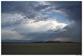
The Mojave, like all deserts in general, is known for its summer heat; however, much less renowned is the Mojave's wintertime cold. Snow, although uncommon, does fall in parts of the Mojave. Amounts range from just a trace to a foot or more of heavy wet snow that can lead to freeway traffic closures and being "snowed in." The coldest wintertime temperature ranges have been below freezing yet above 0°F. That said, many parts of the Mojave typically range from highs of around 95–105°F in the summer to lows of around 20–30°F in the winter.
Wind is also a weather factor. Las Vegas, situated on the desert's east, may not have many winds, but the community of Mojave, California, situated at its western end, can have wind nearly every day — even winds surpassing 50 miles per hour. Nearby Tehachapi Pass, due to the high likelihood of reliable wind, is home to an extensive electrical Wind turbine "Wind farm" which converts wind, a renewable-clean-resource, into electricity.
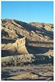
The Mojave Desert contains a number of ghost towns, the most significant of these being the silver-mining town of Calico, California, and the old railroad depot of Kelso, California. Some of the other ghost towns are of the more modern variety, created when Route 66 (and the lesser-known US Highway 91) were abandoned in favor of the Interstates. The Mojave Desert is crossed by major highways Interstate 15, Interstate 40, US Highway 395 and US Highway 95.
The Mojave River is an important source of water in this arid land. A part of the Colorado River also traverses its far eastern portion.
The Mojave Desert is not entirely rural as a few cities do exist there. Las Vegas is the Mojave's largest city and metropolitan area. Palmdale, California is the largest city by population on the California side of the desert and is part of the Lancaster/Palmdale Urbanized Area, a U.S. Census Bureau defined term. Other incorporated cities include; Henderson, North Las Vegas, and Laughlin in Nevada, and Victorville, Barstow, Ridgecrest, and Needles in California.
Angelenos often refer to its southwestern portions, the Antelope Valley and the Victor Valley, as the High Desert.
Native Mojave plants and animals
Plants
Joshua Tree
Jumping Cholla
Teddy-bear Cholla
Mojave yucca
Mojave sage
desert lily
Animals
Chuckwalla
Desert horned lizard
Desert iguana
Desert kit fox
Desert tortoise
Fringe-toed lizard
Rattlesnake (Mojave Green and Western Diamondback)
Zebra-tailed lizard
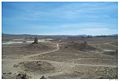
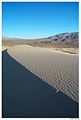
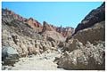
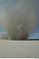
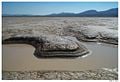
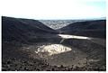
Photos from the Mojave Desert
Pinnacles National Natural Landmark
Slot Canyon in Afton Canyon
Dust Devil, El Mirage Dry Lake
Water hole, Coyote Dry Lake
Rainbow Canyon, near the city of Barstow
External links
Credits
New World Encyclopedia writers and editors rewrote and completed the Wikipedia article
in accordance with New World Encyclopedia standards. This article abides by terms of the Creative Commons CC-by-sa 3.0 License (CC-by-sa), which may be used and disseminated with proper attribution. Credit is due under the terms of this license that can reference both the New World Encyclopedia contributors and the selfless volunteer contributors of the Wikimedia Foundation. To cite this article click here for a list of acceptable citing formats.The history of earlier contributions by wikipedians is accessible to researchers here:
The history of this article since it was imported to New World Encyclopedia:
Note: Some restrictions may apply to use of individual images which are separately licensed.