Difference between revisions of "Sinai Peninsula" - New World Encyclopedia
John Willis (talk | contribs) (created, categorized & credited) |
John Willis (talk | contribs) (woops-wrong Wikip. article-fixed it) |
||
| Line 2: | Line 2: | ||
[[Category:Peninsulas]] | [[Category:Peninsulas]] | ||
| − | [[Image: | + | [[Image:Sinai_Peninsula_from_Southeastern_Mediterranean_panorama_STS040-152-180.jpg|thumb|right|[[Sinai Peninsula]], [[Gulf of Suez]] (west), [[Gulf of Aqaba]] (east) from [[Space Shuttle program|Space Shuttle]] [[STS-40]]]] |
| − | [[ | ||
| − | '' | + | :''Sinai redirects here. You might be looking for [[Mount Sinai]], or the Russian-American [[mathematician]] [[Yakov G. Sinai]].'' |
| − | + | The '''Sinai Peninsula''' (in [[Arabic language|Arabic]], ''Shibh Jazirat Sina'' شبه جزيرة سيناء) is a triangle-shaped [[peninsula]] lying between the [[Mediterranean Sea]] (to the north) and [[Red Sea]] (to the south), located in [[Egypt]] and has an area of about 60,000 square kilometers. Its land borders are the [[Suez Canal]] to the west and the [[Israel]]–[[Egypt]] border to the north-east. The Sinai Peninsula is in [[Southwest Asia]] (also called '''West Asia''' - the more geographically accurate term for the Western term [esp. American usage] of [[Middle East]]) while the rest of [[Egypt]] is in [[North Africa]]. For [[geopolitical]] purposes, the Sinai is often considered part of [[Africa]] (as the rest of Egypt is). | |
| − | + | The Sinai is almost entirely [[desert]], but is settled along the Sabah coast at [[Taba]] (near the Israeli town of [[Eilat]]), where there is a [[hotel]] and [[casino]]. Moving southwards along the coast, there lie: [[Nuweiba]], [[Dahab]] and [[Sharm el-Sheikh]]. The Sinai is also settled on the north coast near the [[Gaza Strip]] at [[El-Arish]]. | |
| − | + | [[Mount Sinai, Egypt|Mount Sinai]] in the Sinai is [[Bible|biblically]] significant as it is allegedly the site where [[Moses]] received the [[Ten Commandments]]. A [[monastery]] situated at [[Saint Catherine's Monastery, Mount Sinai|St. Catherine]] in the southern Sinai Peninsula claims to be at the site of Mount Sinai, though historians and archeologists generally reject this as the site. | |
| − | + | The eastern boundary of the peninsula is a [[geology|geological]] [[Geologic fault|fault]] zone known as the [[Great Rift Valley]], which can be seen from the upper [[Jordan River]] valley, extending southward through the Red Sea into [[Africa]]. | |
| − | + | == History == | |
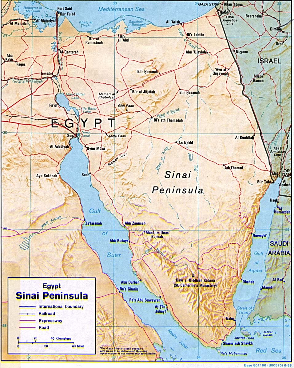
| − | + | [[Image:sinai_peninsula_topo.jpg|thumb|285px|Topography of Sinai Peninsula]] | |
| + | The Sinai was inhabited by the [[Monitu]] and was called ''Mafkat'' or ''Country of Turquoise''. From the time of the [[First dynasty of Egypt|First dynasty]] or before, the Egyptians mined [[turquoise]] in Sinai at two locations, [[Wadi Maghareh]] and [[Serabit el-Khadim]]. They were operated on and off on a seasonal basis for thousands of years. Modern attempts to exploit the deposits have been unprofitable. These may be the first known [[mining|mines]]. | ||
| − | + | === Modern history === | |
| + | Until the early 20th century, Sinai was under the control of the [[Ottoman Empire]]. In [[1906]] it became part of then [[British Empire|British]]-controlled Egypt, when the Turkish government yielded to British pressure to hand over the peninsula. The border imposed by the British runs in an almost straight line from [[Rafah]] on the [[Mediterranean Sea|Mediterranean]] shore to [[Taba]] on the [[Gulf of Aqaba]]. This line served as the eastern border of Sinai ever since, and is now the international border between Israel and Egypt. | ||
| − | + | In [[1948]], Egyptian forces passed through Sinai on their way to invade the newly-created state of [[Israel]] based on a [[United Nations]] mandate dividing the land between the [[Jews]] and the [[Christian]] and [[Muslim]] inhabitants. During the [[1948 Arab-Israeli War]], Israeli forces entered the north-eastern corner of Sinai, but withdrew shortly after, following British and American pressure. Under the terms of the [[1949 Armistice Agreement]], Sinai, together with the Gaza Strip, remained under Egyptian control, although parts of it were demilitarized. | |
| + | In [[1956]], Egypt used its control of Sinai to impose a blockade on the Israeli port of [[Eilat]]. Following this, Israeli forces, aided by Britain and France (which sought to regain control over the Suez Canal) invaded Sinai, and took control over the entire peninsula within several days (see [[Suez Crisis]]). Several months later, Israel withdrew its forces from Sinai, following strong American and Russian pressure. Following this, the [[United Nations Emergency Force]], the UNEF, was stationed in Sinai to prevent any military occupation of the Sinai. | ||
| − | + | In [[1967]], Egypt reinforced its military presence in Sinai, renewed the [[blockade]] on Eilat, and on [[May 16]] ordered the UNEF out of Sinai effective immediately. In the following [[Six-Day War]], the Egyptian army was defeated, and Israel took control over the entire peninsula. The [[Suez Canal]], whose east bank was now controlled by Israel, was closed. | |
| − | + | In the [[1973]] [[1973 Yom Kippur War|Yom Kippur War]], Egyptian forces built pontoon bridges to cross the Suez Canal and stormed the supposedly impregnable Barlev Line to gain control of most of the Eastern Bank. Some held positions and others were pushed back across the Suez Canal, the war ending with some of each side's forces on both sides of the canal. As part of the subsequent [[Sinai Disengagement Agreements]], Israel withdrew from west of the canal and pulled out of an additional strip in the western Sinai—while Egyptians held positions in Sinai—allowing for the later re-opening of the canal eventually under Egyptian control. | |
| − | |||
| − | + | In [[1979]] Israel and Egypt signed a [[Israel-Egypt Peace Treaty|Peace Treaty]], in which Israel agreed to transfer all control over Sinai to Egypt. Subsequently, Israel pulled out of Sinai in several stages, ending in [[1982]]. The Israeli pull-out involved the destruction of several Israeli settlements including the town of [[Yamit]] in north-eastern Sinai. | |
| − | + | ==Present== [[Image:Santa Catarina Sinai 2003.JPG|thumb|250px|[[Saint Catherine's Monastery, Mount Sinai|St Catherine Monastery]] is the oldest monastery in the world and the most popular tourist attraction on the peninsula]]. | |
| − | + | The Sinai Peninsula is currently divided among several [[governorates]], or provinces, of Egyptian administration. The southern portion of the Sinai is called [[Janub Sina']] in Arabic, literally "Sinai South." The northern portion is named [[Shamal Sina']], or "Sinai North." the other three governates converge on the [[Suez Canal]], including [[Al Isma'iliyah]] on its southern end and crosses into [[Egypt]]-proper. In the center is [[As Suways]], literally "the Suez;" and [[Bur Sa'id]] lies in the north with its capital at [[Port Said]]. | |
| − | {{credit| | + | Approximately 66,500 live in [[Janub Sina']] and 314,000 live in [[Shamal Sina']]. [[Port Said]] itself has a population of roughly 500,000, while the rest of the governorate ([[Bur Sa'id]]) itself. Portions of the populations of [[Al Isma'iliyah]] and [[As Suways]] live in Sinai, while the rest live on the western side of the [[Suez Canal]] in [[Egypt]]-proper. The combined population of these two governorates is roughly 1.3 million (only a part of that population live in the Sinai, while the rest live on the western side of the [[Suez]]). |
| + | |||
| + | == Other References == | ||
| + | |||
| + | The [[Israelites]] made one of their camps during [[the Exodus]] in an unspecified part of the Sinai desert. | ||
| + | {{ExodusStation|[[Rephidim]]|[[Kibroth Hattaavah]]}} | ||
| + | |||
| + | ==See also== | ||
| + | *[[Desert of Paran]] | ||
| + | |||
| + | == External links == | ||
| + | * [http://wikitravel.org/en/Sinai Wikitravel: Sinai] | ||
| + | * [http://ancientneareast.tripod.com/Sinai_Peninsula.html The History of the Ancient Near East] | ||
| + | * [http://www.geographia.com/egypt/sinai/ Geographia: Sinai] | ||
| + | * [http://us.aminet.net/pix/map/Sinai.jpg Map of the Sinai] | ||
| + | * [http://www.world-gazetteer.com/wg.php?x=1116651677&men=gadm&lng=en&gln=xx&dat=32&srt=npan&col=aohdq&geo=-69 Egypt Governates] | ||
| + | |||
| + | {{credit|31323985}} | ||
Revision as of 02:17, 16 December 2005

- Sinai redirects here. You might be looking for Mount Sinai, or the Russian-American mathematician Yakov G. Sinai.
The Sinai Peninsula (in Arabic, Shibh Jazirat Sina شبه جزيرة سيناء) is a triangle-shaped peninsula lying between the Mediterranean Sea (to the north) and Red Sea (to the south), located in Egypt and has an area of about 60,000 square kilometers. Its land borders are the Suez Canal to the west and the Israel–Egypt border to the north-east. The Sinai Peninsula is in Southwest Asia (also called West Asia - the more geographically accurate term for the Western term [esp. American usage] of Middle East) while the rest of Egypt is in North Africa. For geopolitical purposes, the Sinai is often considered part of Africa (as the rest of Egypt is).
The Sinai is almost entirely desert, but is settled along the Sabah coast at Taba (near the Israeli town of Eilat), where there is a hotel and casino. Moving southwards along the coast, there lie: Nuweiba, Dahab and Sharm el-Sheikh. The Sinai is also settled on the north coast near the Gaza Strip at El-Arish.
Mount Sinai in the Sinai is biblically significant as it is allegedly the site where Moses received the Ten Commandments. A monastery situated at St. Catherine in the southern Sinai Peninsula claims to be at the site of Mount Sinai, though historians and archeologists generally reject this as the site.
The eastern boundary of the peninsula is a geological fault zone known as the Great Rift Valley, which can be seen from the upper Jordan River valley, extending southward through the Red Sea into Africa.
History
The Sinai was inhabited by the Monitu and was called Mafkat or Country of Turquoise. From the time of the First dynasty or before, the Egyptians mined turquoise in Sinai at two locations, Wadi Maghareh and Serabit el-Khadim. They were operated on and off on a seasonal basis for thousands of years. Modern attempts to exploit the deposits have been unprofitable. These may be the first known mines.
Modern history
Until the early 20th century, Sinai was under the control of the Ottoman Empire. In 1906 it became part of then British-controlled Egypt, when the Turkish government yielded to British pressure to hand over the peninsula. The border imposed by the British runs in an almost straight line from Rafah on the Mediterranean shore to Taba on the Gulf of Aqaba. This line served as the eastern border of Sinai ever since, and is now the international border between Israel and Egypt.
In 1948, Egyptian forces passed through Sinai on their way to invade the newly-created state of Israel based on a United Nations mandate dividing the land between the Jews and the Christian and Muslim inhabitants. During the 1948 Arab-Israeli War, Israeli forces entered the north-eastern corner of Sinai, but withdrew shortly after, following British and American pressure. Under the terms of the 1949 Armistice Agreement, Sinai, together with the Gaza Strip, remained under Egyptian control, although parts of it were demilitarized.
In 1956, Egypt used its control of Sinai to impose a blockade on the Israeli port of Eilat. Following this, Israeli forces, aided by Britain and France (which sought to regain control over the Suez Canal) invaded Sinai, and took control over the entire peninsula within several days (see Suez Crisis). Several months later, Israel withdrew its forces from Sinai, following strong American and Russian pressure. Following this, the United Nations Emergency Force, the UNEF, was stationed in Sinai to prevent any military occupation of the Sinai.
In 1967, Egypt reinforced its military presence in Sinai, renewed the blockade on Eilat, and on May 16 ordered the UNEF out of Sinai effective immediately. In the following Six-Day War, the Egyptian army was defeated, and Israel took control over the entire peninsula. The Suez Canal, whose east bank was now controlled by Israel, was closed.
In the 1973 Yom Kippur War, Egyptian forces built pontoon bridges to cross the Suez Canal and stormed the supposedly impregnable Barlev Line to gain control of most of the Eastern Bank. Some held positions and others were pushed back across the Suez Canal, the war ending with some of each side's forces on both sides of the canal. As part of the subsequent Sinai Disengagement Agreements, Israel withdrew from west of the canal and pulled out of an additional strip in the western Sinai—while Egyptians held positions in Sinai—allowing for the later re-opening of the canal eventually under Egyptian control.
In 1979 Israel and Egypt signed a Peace Treaty, in which Israel agreed to transfer all control over Sinai to Egypt. Subsequently, Israel pulled out of Sinai in several stages, ending in 1982. The Israeli pull-out involved the destruction of several Israeli settlements including the town of Yamit in north-eastern Sinai.
==Present==

.
The Sinai Peninsula is currently divided among several governorates, or provinces, of Egyptian administration. The southern portion of the Sinai is called Janub Sina' in Arabic, literally "Sinai South." The northern portion is named Shamal Sina', or "Sinai North." the other three governates converge on the Suez Canal, including Al Isma'iliyah on its southern end and crosses into Egypt-proper. In the center is As Suways, literally "the Suez;" and Bur Sa'id lies in the north with its capital at Port Said.
Approximately 66,500 live in Janub Sina' and 314,000 live in Shamal Sina'. Port Said itself has a population of roughly 500,000, while the rest of the governorate (Bur Sa'id) itself. Portions of the populations of Al Isma'iliyah and As Suways live in Sinai, while the rest live on the western side of the Suez Canal in Egypt-proper. The combined population of these two governorates is roughly 1.3 million (only a part of that population live in the Sinai, while the rest live on the western side of the Suez).
Other References
The Israelites made one of their camps during the Exodus in an unspecified part of the Sinai desert. Template:ExodusStation
See also
- Desert of Paran
External links
- Wikitravel: Sinai
- The History of the Ancient Near East
- Geographia: Sinai
- Map of the Sinai
- Egypt Governates
Credits
New World Encyclopedia writers and editors rewrote and completed the Wikipedia article in accordance with New World Encyclopedia standards. This article abides by terms of the Creative Commons CC-by-sa 3.0 License (CC-by-sa), which may be used and disseminated with proper attribution. Credit is due under the terms of this license that can reference both the New World Encyclopedia contributors and the selfless volunteer contributors of the Wikimedia Foundation. To cite this article click here for a list of acceptable citing formats.The history of earlier contributions by wikipedians is accessible to researchers here:
The history of this article since it was imported to New World Encyclopedia:
Note: Some restrictions may apply to use of individual images which are separately licensed.