Difference between revisions of "Mount Hood" - New World Encyclopedia
m (→Climbing) |
(→Wildlife and Recreation: added info and reference) |
||
| Line 86: | Line 86: | ||
Mount Hood is home to more than 300 species of fish and wildlife. Deer, elk, coyotes, and black bear are just a few of the animals that make their home on the mountain. Along its rivers and little streams and mountain lakes, fishing for small mouth bass, rainbow trout, chinook salmon or steelhead is a popular sport. Some of the common birds found in the Mount Hood wetlands are herons, Canadian geese, and mallard ducks. Hummingbirds, Western Meadowlark, Towhees, Northern Flickers, Steller Jays, Pileated Woodpeckers and many species of hawks and owls, including the spotted owl are among the birds that build their nests in old snags and forest groves on Mount Hood. | Mount Hood is home to more than 300 species of fish and wildlife. Deer, elk, coyotes, and black bear are just a few of the animals that make their home on the mountain. Along its rivers and little streams and mountain lakes, fishing for small mouth bass, rainbow trout, chinook salmon or steelhead is a popular sport. Some of the common birds found in the Mount Hood wetlands are herons, Canadian geese, and mallard ducks. Hummingbirds, Western Meadowlark, Towhees, Northern Flickers, Steller Jays, Pileated Woodpeckers and many species of hawks and owls, including the spotted owl are among the birds that build their nests in old snags and forest groves on Mount Hood. | ||
Mount Hood Territory is defined by the borders of Clackamas County, Oregon. This scenic region includes the following incorporated cities: Canby, Clackamas, Damascus, Estacada, Gladstone, Happy Valley, Lake Oswego, Milwaukie, Molalla, Oregon City, Sandy, West Linn, Wilsonville, and the Villages of Mt. Hood (Government Camp, Welches, Brightwood, Rhododendron and Zigzag).http://www.mthoodterritory.com/. Mount Hood National Forest is managed mainly by the U.S. Forest Service and the Bureau of Land Management. Hood Territory is home to two major environmental educational sites, Inkeep Environmental Learning Center located at Clackamas Community College and the Cascade Streamwatch at the Wildwood Reacreation Center. The ladder site, focusses on watershed and wetland protection and provides a wetland boardwalk interpretive trail for visitors. Mount Hood offers recreation year round. It has one of the only ski resorts in the northwest that remains open year round. Biking, camping, fishing hiking, horseback riding, are popular. http://www.fs.fed.us/recreation/programs/nvum/reports/year4/R6_F6_mounthood_final.htm#_Toc75065186 One can also relax, which is the most popular pass time for visitors to the mountain. Hiking and walking was second and the third most popular activity at Mount Hood is downhill skiing. There are also many hot springs, other winter sports along with birdwatching and picniking but just enjoying the scenary made Mount Hood one of the most frequented National Forest in the United States. Oregonian Thursday Sept 20 edition. | Mount Hood Territory is defined by the borders of Clackamas County, Oregon. This scenic region includes the following incorporated cities: Canby, Clackamas, Damascus, Estacada, Gladstone, Happy Valley, Lake Oswego, Milwaukie, Molalla, Oregon City, Sandy, West Linn, Wilsonville, and the Villages of Mt. Hood (Government Camp, Welches, Brightwood, Rhododendron and Zigzag).http://www.mthoodterritory.com/. Mount Hood National Forest is managed mainly by the U.S. Forest Service and the Bureau of Land Management. Hood Territory is home to two major environmental educational sites, Inkeep Environmental Learning Center located at Clackamas Community College and the Cascade Streamwatch at the Wildwood Reacreation Center. The ladder site, focusses on watershed and wetland protection and provides a wetland boardwalk interpretive trail for visitors. Mount Hood offers recreation year round. It has one of the only ski resorts in the northwest that remains open year round. Biking, camping, fishing hiking, horseback riding, are popular. http://www.fs.fed.us/recreation/programs/nvum/reports/year4/R6_F6_mounthood_final.htm#_Toc75065186 One can also relax, which is the most popular pass time for visitors to the mountain. Hiking and walking was second and the third most popular activity at Mount Hood is downhill skiing. There are also many hot springs, other winter sports along with birdwatching and picniking but just enjoying the scenary made Mount Hood one of the most frequented National Forest in the United States. Oregonian Thursday Sept 20 edition. | ||
| + | |||
| + | http://www.mefeedia.com/feeds/22881/ An organization called BARK is calling on the Forest Service to protect the mountain from motor vehicles including OHV's. Mount Hood is the first National Forest in the Pacific Northwest to implement the Traveling Plan Rule. This rule designates the roads, trails and areas that are open to motorized vehicles. Mount Hood has approximately 4,000 miles of roads. Some of the roads which have not been maintained are causing problems with the watersheds that are a source of drinking water. They are also causing erosion and harm to the wildlife. By monitoring the access of these vehicles,less damage will result to the natural habitat on the mountain. | ||
==Geology== | ==Geology== | ||
Revision as of 15:01, 21 September 2007
| Mount Hood | |||
|---|---|---|---|
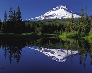 Mount Hood reflected in Trillium Lake | |||
| Elevation | 11,249 feet (3,429 meters) | ||
| Location | Oregon, USA | ||
| Mountain range | Cascade Range | ||
| Prominence | 7,706 ft (2,349 m)[1] | ||
| Geographic coordinates | {{#invoke:Coordinates|coord}}{{#coordinates:45|22|24.65|N|121|41|45.31|W|type:mountain_region:US | name=
}} | |
| Topographic map | USGS Mount Hood South 45121-C6 | ||
| Type | Stratovolcano | ||
| Geologic time scale | < 500,000 years[2] | ||
| Last eruption | 1790s[2] | ||
| First ascent | 1857-07-11 by Henry Pittock, W. Lymen Chittenden, Wilbur Cornell, and the Rev. T.A. Wood[3] | ||
| Easiest Climbing route | Rock and glacier climb | ||
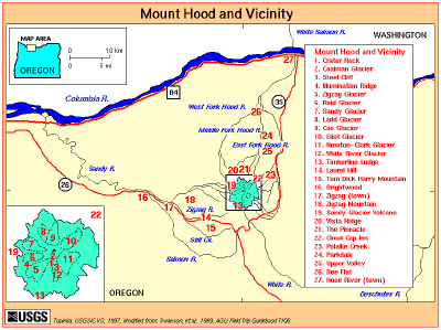
Mount Hood (called Wy'east by the Multnomah tribe, is a stratovolcano in the Cascade Volcanoes Arc in northern Oregon, in the Pacific Northwest region of the United States. It is located about 50 miles (80 km) east-southeast of the city of Portland, Oregon, on the border between Clackamas County, Oregon and Hood River County.
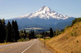
Mount Hood's snow-covered peak rises 11,249 ft (3,429 meters) and is home to twelve glaciers. It is the highest mountain in Oregon and the fourth-highest in the Cascade Range. Mount Hood is considered the most likely of the Oregon volcanos to erupt.[4] Although, based on its history, an explosive eruption is unlikely. Still, the odds of an eruption in the next 30 years are estimated at between 3 and 7 percent.[5] The USGS characterizes it as "potentially active".[6] The mountain is sometimes informally described as "dormant" ("asleep").
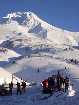
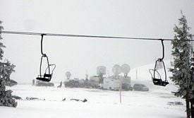
Timberline Lodge is a National Historic Landmark located on the southern flank of Mount Hood just below Palmer Glacier. The mountain has six ski areas: Timberline, Mount Hood Meadows, Ski Bowl, Cooper Spur, Snow Bunny and Summit. They total over 4,600 acres (7.2 mi², 18.6 km²) of skiable terrain; Timberline offers the only year-round lift-served skiing in North America. Mount Hood is part of the Mount Hood National Forest, which has 1.2 million acres (4,900 km²), four designated wilderness areas, and more than 1,200 mi (1,900 km) of hiking trails.
Origin of its name
The mountain was given its present name on October 29, 1792 by Lt. William Broughton, a member of Captain George Vancouver's discovery expedition. It was named after a British admiral, Samuel Hood.
The Multnomah name for Mount Hood is Wy'east. Legend has it that the name Wy'east comes from a chief of the Multnomah tribe, the tribe after which Multnomah County was named. The chief competed for the attention of a woman who was also loved by the chief of the Klickitat Tribe. The anger that the competition generated led to their transformations into volcanoes, with the Klickitat chief becoming nearby Mount Adams (Washington) and the target of their affection becoming Mount St. Helens. Their battle was said to have destroyed the Bridge of the Gods, a 200 feet high landslide that crossed the Columbia River around 300 years ago, and thus created the Great Cascades of the Columbia River.[7]
Wildlife and Recreation
Mount Hood is home to more than 300 species of fish and wildlife. Deer, elk, coyotes, and black bear are just a few of the animals that make their home on the mountain. Along its rivers and little streams and mountain lakes, fishing for small mouth bass, rainbow trout, chinook salmon or steelhead is a popular sport. Some of the common birds found in the Mount Hood wetlands are herons, Canadian geese, and mallard ducks. Hummingbirds, Western Meadowlark, Towhees, Northern Flickers, Steller Jays, Pileated Woodpeckers and many species of hawks and owls, including the spotted owl are among the birds that build their nests in old snags and forest groves on Mount Hood. Mount Hood Territory is defined by the borders of Clackamas County, Oregon. This scenic region includes the following incorporated cities: Canby, Clackamas, Damascus, Estacada, Gladstone, Happy Valley, Lake Oswego, Milwaukie, Molalla, Oregon City, Sandy, West Linn, Wilsonville, and the Villages of Mt. Hood (Government Camp, Welches, Brightwood, Rhododendron and Zigzag).http://www.mthoodterritory.com/. Mount Hood National Forest is managed mainly by the U.S. Forest Service and the Bureau of Land Management. Hood Territory is home to two major environmental educational sites, Inkeep Environmental Learning Center located at Clackamas Community College and the Cascade Streamwatch at the Wildwood Reacreation Center. The ladder site, focusses on watershed and wetland protection and provides a wetland boardwalk interpretive trail for visitors. Mount Hood offers recreation year round. It has one of the only ski resorts in the northwest that remains open year round. Biking, camping, fishing hiking, horseback riding, are popular. http://www.fs.fed.us/recreation/programs/nvum/reports/year4/R6_F6_mounthood_final.htm#_Toc75065186 One can also relax, which is the most popular pass time for visitors to the mountain. Hiking and walking was second and the third most popular activity at Mount Hood is downhill skiing. There are also many hot springs, other winter sports along with birdwatching and picniking but just enjoying the scenary made Mount Hood one of the most frequented National Forest in the United States. Oregonian Thursday Sept 20 edition.
http://www.mefeedia.com/feeds/22881/ An organization called BARK is calling on the Forest Service to protect the mountain from motor vehicles including OHV's. Mount Hood is the first National Forest in the Pacific Northwest to implement the Traveling Plan Rule. This rule designates the roads, trails and areas that are open to motorized vehicles. Mount Hood has approximately 4,000 miles of roads. Some of the roads which have not been maintained are causing problems with the watersheds that are a source of drinking water. They are also causing erosion and harm to the wildlife. By monitoring the access of these vehicles,less damage will result to the natural habitat on the mountain.
Geology
Mount Hood is estimated to be more than 500,000 years old. About 100,000 years ago there was a major eruption that scientist have identified. During this eruption, the North flank collapsed, levelling part of the mountains peak. As the laher moved down in the area of the Hood River Valley, it carried with it sediment more that 400 ft. deep. Moving north, down the Columbia River, the debris left a huge scare as evidence of its path. This scare has now been filled with lava.
The eroded volcano has had at least four major eruptive periods during the past 15,000 years. The last three occurred within the past 1,800 years. 1,500 years ago, vents high on the southwest flank produced deposits that were distributed primarily to the south and west along the Sandy River and Zigzag Rivers. During this eruption, a debris avalanche formed the ammphitheater around Crater Rock near the summit which is still visible today.http://pubs.usgs.gov/fs/2000/fs060-00/. Subduction of the Juan de Fuca Plate under the North American Plate controls the distribution of earthquakes and volcanoes in the Pacific Northwest.
The last eruptive period took place around 220 years ago, in 1781-1782. This episode ended shortly before the arrival of Lewis and Clark in 1805.
Now, the glacially eroded summit area consists of several andesitic or dacitic lava domes; These domes are formed when the slow moving lava flow piles up over the vents. This piling up can eventually cause more dangerous, pyroclastic flows. The "domes" on Hood, sometimes several hundred feet high, can collapse (Pleistocene collapses), producing avalanches and lahars (rapidly moving mudflows). .
In 1980, a lahar, caused by servere rainstorms, resulted in one death, destroyed a park, three bidges and 5 miles of highway. The most recent minor eruptive event occurred in August 1907. [8] Since 1950, there have been several earthquake swarms each year at Mount Hood, most notably in July 1980, and June 2002 [1][2]. Seismic activity is monitored by the USGS Cascades Volcano Observatory located in Vancouver, Washington, which issues daily updates[9].There are twelve glaciers on the mountain's upper slopes; these may be a source of potentially dangerous lahars if the mountain should erupt. Scientists say that Mount Hood will erupt again. To the UsGs monitor the active volcano and find that it has 1-4 small earthqueake swarms lasting 2-6 days every years. It the temperature neare the sevice gets hooter or there is more seimic activity than
Glaciers
Mount Hood is host to twelve named glaciers, the most visited of which is Palmer Glacier. This glacier is part of the Timberline Lodge ski area, a popular climbing route. The glaciers are almost exclusively above the 6,000 foot level, which also is about the level of the average tree line on Mount Hood.
The surface area of the glaciers totals about 145 million square feet (5.2 square miles) and contains a volume of about 12.3 billion cubic feet (0.084 cubic miles). Eliot Glacier is the largest by volume at 3.2 billion cubic feet, and has the thickest depth measured by ice radar at 361 feet. The largest surface area is the Coe-Ladd Glacier system at 23.1 million square feet.
| Glacier name | Area[10] millions of ft² |
Volume[10] billions of ft³ |
notes | GNIS location[11] |
|---|---|---|---|---|
| Palmer | 1.4 | 0.07 | upper slopes of the south side,feeds the White River | |
| Coalman (or "Coleman") | 0.9 | 0.04 | located between Crater Rock and the summit, drains into White River | |
| White River | 5.8 | 0.3 | feeds the White River | |
| Newton Clark | 21.4 | 1.4 | source of the East Fork Hood River | |
| Eliot | 18.1 | 3.2 | source of Tilly Jane Creek and Eliot Branch, tributaries of Middle Fork Hood River | |
| Langille | 4.3 | 0.3 | in Hood River watershed | |
| Coe | 13.4 | 1.9 | source of Coe Branch, a tributary of Middle Fork Hood River | |
| Ladd | 9.7 | 0.9 | source of McGee Creek, a tributary of West Fork Hood River | |
| Glisan | ||||
| Sandy | 12.8 | 0.08 | feeds Muddy Fork, a tributary of the Sandy River | |
| Reid | 8.1 | 0.6 | feeds the Sandy River | |
| Zigzag | 8.3 | 0.6 | feeds the Zigzag River | |
| (total) | 145.1 | 12.3 | ||
Climbing
Its status as Oregon's highest point, a prominent landmark visible up to a hundred miles away, convenient access, and relative lack of technical climbing challenges lure many to climb Mount Hood. About 10,000 people attempt to climb each year.[12]
There is some debate as to when the summit was first reached: either in 1845 or 1857. Since those early days, hundreds of thousands have scaled Oregon's highest peak, and today Mt. Hood is the most frequently climbed glaciated peak in North America.
The most popular route, dubbed the south route, begins at Timberline Lodge and proceeds up Palmer glacier to Crater Rock, the large prominence at the head of the glacier. Climbers then proceed around Crater Rock and cross Coalman glacier on the Hogsback, a ridge spanning from Crater Rock to the approach to the summit. The Hogsback terminates at a bergschrund where Coalman glacier separates from the summit rock headwall, and then to the Pearly Gates, a gap in the summit rock formation. Once through the Pearly Gates, climbers proceed to the right onto the summit plateau and then to the summit proper.[13]
As of Spring 2007, reported changes in the formation of the popular South Route has increased the difficulty of the climb. Reportedly, the Hogsback has shifted west. Also, a technical "ice chute" has formed in the Pearly Gates. Some climbers are opting to climb the "left chute" variation of the Pearly Gates route, but this has also increased the difficulty of the climb, as it is also a technical ice wall 30ft or greater in height, and with fall exposure of 500+ feet. Technical ice axes, fall protection, and experience are now recommended in order to attempt the "left chute" variation or Pearly Gates ice chute. The Forest Service is recommending several other route options due to these changes in conditions ("Old Chute," West Crater Rim, etc). [14]
Climbing accidents
More than 130 people have died in climbing-related accidents since records have been kept on Mount Hood.[15] Cascade Range weather patterns are unfamiliar to many, even nearby residents. Prior to the 1980 eruption of Mount St. Helens, the only known fatality related to volcanic activity in the Cascades occurred in 1934 when a climber suffocated in oxygen-poor air while exploring ice caves melted by fumaroles in the Coalman Glacier. There are vents near the summit that are known for emitting noxious gases such as carbon dioxide and sulfur dioxide.
Seduced by gentle wind and warm air at access points, many are surprised to encounter 60 °F temperature drops in less than an hour, sudden sustained winds of 60 mph and more, and visibility quickly dropping from hundreds of miles to an arm's length. This pattern is responsible for the most well known incidents of May 1986 and December 2006. One of the worst U.S. climbing accidents occurred in May 1986 when seven students and two faculty of the Oregon Episcopal School froze to death during an annual school climb.[15][16]
Despite a quadrupling of forest visitors since 1990, the number of people requiring rescue remains steady at around 25 to 50 per year, largely because of the increased use of cell phones and GPS devices.[17] Of those, 3.4 percent of last year's search and rescue missions were for mountain climbers. In comparison, 20% were for vehicles (including ATVs and snowmobiles), 3% were for mushroom collectors, the remaining 73.6 percent were for skiers, boaters, and participants in other mountain activities.[18]
Hazards
Avalanches are popularly regarded to be a major climbing hazard, but relatively few Mount Hood deaths are attributed to them. For the eleven year period from December 1994 ending in April 2006,[19] there was only one death on Mount Hood caused by an avalanche.[20] [21] Compared to other western states, Oregon has the fewest avalanche fatalities.[22]. Worldwide, between 100 and 200 people die each year from avalanches.[23]
The two major causes of climbing deaths on Mount Hood are falls and hypothermia.[24][25]
Incident history
According to Mount Hood: A Complete History by Jack Grauer, the first recorded climbing fatality on Hood's slopes occurred on July 121896, when Frederic Kirn eschewed his guide and attempted the trip to the summit alone.[26] Kirn's body was found on the Newton Clark Glacier on the east side of the mountain, after an apparent 40-story fall in connection with an avalanche.
In an unusual accident reported in Grauer's book, on August 27, 1934, Victor VonNorman successfully climbed the peak via the southern route, along with a group of fellow University of Washington students. He then ventured too close to a fumarole between Crater Rock and the "Hogsback" that connects Crater Rock with the summit ridge, was overcome by oxygen-barren gasses emanating from the fumarole, and fell about 50 feet to his death. A number of men who tried to retrieve the body were also nearly overcome by the fumes before finally succeeding in their efforts.[27]
Beginning on New Year's Eve in 1975, two 16-year-olds and an 18-year-old survived in a snow cave 13 days through a snow storm.[28]
One of the worst U.S. climbing accidents occurred in May 1986 when seven students and two faculty of the Oregon Episcopal School froze to death during an annual school climb.[15] Of the four survivors, three had life-threatening hypothermia; one had legs amputated.[29]
On May 31, 1998 during a graduation climb for The Mazamas mountaineering club, several were caught by an avalanche. One died, one had serious injuries.[30]
On May 23, 1999, an experienced pair of climbers summited successfully. Shortly after commencing their descent, one stumbled and both fell more than 2,000 feet to their deaths.[31]
On June 22, 1999, a 24-year-old medical student from Michigan apparently set out from a remote trailhead where his rental car was found. Temperatures dropped 15 degrees and more than an inch of rain fell beginning the next day. Ten days after his presumed disappearance, searching began with up to 70 rescuers combing the area. Additional searches included cadaver dogs and psychics. No sign of him was found.[17]
On September 8, 2001, rescuers abandoned a search for a 24-year-old Hungarian exchange student who had been missing for six days. He had been hiking with friends when he left the group with light clothing and no provisions. Two days after his disappearance, the weather turned cold and snowy.[32]
On May 24, 2002, a 30-year-old Argentine national attempted to snowboard off Mount Hood's summit along Cooper Spur ridge. He lost control after a few turns and tumbled over 2,000 feet to his death.[33]
On May 30, 2002, three climbers were killed and four others injured when they fell into a crevasse (The Bergschrund) in the "hogsback". Most unusual was the televised crash-and-roll of a rescue helicopter whose rotors clipped the sloping ice bridge.[34]
On March 7, 2003, the search for a man snowshoeing from Timberline Lodge was abandoned after more than four days in heavy winter weather. More than six feet of snow fell during the search.[35] An extensive search five months later for the man's body failed, but unexpectedly discovered the body of another man who was not identified.[36] On Thursday, December 7, 2006, three experienced climbers—Kelly James, Brian Hall, and Jerry Cooke—began what they expected to be a two-day expedition on the more-treacherous north slope of the mountain. On Sunday, December 10,2006, the climbers failed to rendezvous as scheduled with friends, and James made a cell phone call to family members indicating that the group was separated and in trouble.[37] Rescue attempts were forestalled by freezing rain, heavy snowfall, low visibility and winds of 100 to 140 mph, caused by the widespread, December 2006, Pacific Northwest storms. The last sign of them alive was a signal from James' cell phone late on the night of Tuesday, December 12, indicating it had been turned on.[38] Clear weather on the weekend of December 16 allowed almost 100 search and rescue personnel to scour the mountain. On Sunday, December 17, searchers found a snow cave and climbing equipment, approximately 300 feet from the summit.[39] Inside the snow cave, the rescuers found a rope, two ice axes and an insulating sleeping pad. At approximately 3:29 PM PST, the body of Kelly James was found in another snow cave near the first one. On Wednesday, December 20 2006, as good weather ended, the Hood River County sheriff announced that the mission was now being treated as a recovery rather than a rescue.[40] Brian Hall and Jerry Cooke remain missing and are presumed dead.[41]
On the morning of Saturday, February 17, 2007, eight experienced climbers from the Portland area ascended in sunny, mild weather. Observing worse weather mid-afternoon, they camped at the Template:Unit ft level of Illumination Saddle overnight. Sunday morning, they abandoned a summit attempt and descended in freezing rain and snow, visibility less than Template:Unit ft, and winds at 40 to 70 mph (64 to 120 km/h). At about noon, disoriented, three of the climbers and a black lab stepped off a cliff (at the Template:Unit ft foot level at the east edge of Palmer Glacier) while tethered together and tumbled down several hundred feet of steep slope into White River Canyon. One of the remaining five climbers was lowered by rope to search for the fallen group, but returned without seeing them. They called for help by cell phone, and were advised of even worse weather advancing. They dug in expecting another night, but rescuers arrived and evacuated them Sunday evening. The three fallen climbers were unable to dig into solid ice to build a snow cave, so they improvised a shelter and were in hourly cell phone contact with rescuers. They had a Mountain Locator Unit, sleeping bags, GPS, and a tarp. The dog, Velvet, helped keep them warm. Rescuers arrived Monday about 10:45 am. One was hospitalized for a head injury, the others were treated for minor injuries and released. The dog had broken nails and a cut on one of her back legs from cold exposure.[12] [42] [43] [44]
On May 12,2007, five climbers were stranded at the Template:Unit ft level by whiteout conditions. The climbers contacted rescuers by cell phone and obtained assistance to navigate to Illumination Saddle, on the south side of the mountain. Using their GPS navigation unit, the climbers traversed to the saddle and descended the mountain without further incident. The climbers carried a Mountain Locator Unit with them, which would have allowed rescuers to pinpoint their location, had they not been able to descend from the mountain on their own.[45]
See also
- Mount Hood Corridor
- Mount Hood Railroad
- Cascade Volcanoes
ReferencesISBN links support NWE through referral fees
- ↑ Mount Hood, Oregon, 11,239 feet, 3426 meters.
- ↑ 2.0 2.1 Mount Hood—History and Hazards of Oregon's Most Recently Active Volcano. U.S. Geological Survey Fact Sheet 060-00. USGS and USFS (June 13,2005). Retrieved 2007-01-16.
- ↑ Glaciers of Oregon. Departments of Geology and Geography at Portland State University. Retrieved 2007-02-24. quoting McNeil, Fred H. (1937). Wy'East The Mountain, A Chronicle of Mount Hood. Metropolitan Press. ASIN B000H5CB6E, ASIN B00085VH7W.
- ↑ Recent Mount Hood Earthquakes. Pacific Northwest Seismic Network. Retrieved 2006-12-15.
- ↑ W.E. Scott, T.C. Pierson, S.P. Schilling, J.E. Costa, C.A. Gardner, J.W. Vallance, and J.J. Major. Volcano Hazards in the Mount Hood Region, Oregon. USGS. Retrieved 2007-02-26.
- ↑ W.E. Scott, T.C. Pierson, S.P. Schilling, J.E. Costa, C.A. Gardner, J.W. Vallance, and J.J. Major (1997). Volcano Hazards in the Mount Hood Region, Oregon (pdf). USGS and US Dept of the Interior. Retrieved 2007-02-26.
- ↑ The Legend of Wy'east. Retrieved 2006-12-19. citing Ella E. Clark (1953). Indian Legends of the Pacific Northwest. University of California Press. ISBN 0520239261.
- ↑ Mount Hood Volcano, Oregon. USGS Cascades Volcano Observatory. Retrieved 2007-01-16.
- ↑ http://vulcan.wr.usgs.gov/Volcanoes/Cascades/CurrentActivity/current_updates.html Retrieved June 5, 2007.
- ↑ 10.0 10.1 Carolyn L. Driedger and Paul M. Kennard (1986). Ice Volumes on Cascade Volcanoes: Mount Rainier, Mount Hood, Three Sisters and Mount Shasta. Geological Survey Professional Paper 1365. USGS. Retrieved 2007-02-26.
- ↑ Portland State University Northwest GeoData Clearinghouse. Retrieved 2007-02-21.
- ↑ 12.0 12.1 Aimee Green, Mark Larabee and Katy Muldoon (February 19,2007). Everything goes right in Mount Hood search. The Oregonian/OregonLive.com. Retrieved 2007-02-26.
- ↑ Climbing Mount Hood. United States Forest Service. Retrieved 2007-02-02.
- ↑ Mount Hood Climbing Report, May 17th. United States Forest Service. Retrieved 2007-05-17.
- ↑ 15.0 15.1 15.2 Last Body Recovered From Mount Hood. CBS news (May 312002). Retrieved 2007-05-25.
- ↑ "Doctors Remove Legs Of Mount Hood Climber", New York Times, May 19,1986. Retrieved 2006-12-19.
- ↑ 17.0 17.1 Nigel Jaquiss (October 131999). Without A Trace. Willamette Week. Retrieved 2006-12-19.
- ↑ Kristi Keck (February 202007). Weighing the risks of climbing on Mount Hood. CNN. Retrieved 2007-02-20.
- ↑ according to the Westwide Avalanche Network
- ↑ [[Template:SpamD] Oregon - Avalanche History]. Oregon Mountaineering Association. Retrieved 2007-02-26.
- ↑ Previous Season Avalanche Accidents. Westwide Avalanche Network. Retrieved 2006-12-16.
- ↑ U.S. Avalanche Fatalities by State 1996-2002. Utah Avalanche Center. Retrieved 2006-12-16.
- ↑ Avalanche Fatalities in IKAR Countries 1976-2001. Utah Avalanche Center. Retrieved 2006-12-16.
- ↑ See incident history.
- ↑ GORP Mount Hood climbing description. Retrieved 2007-04-17.
- ↑ Jack Grauer (July 1975). Mount Hood: A Complete History. self published. ISBN 0-930584-01-5.
- ↑ Details at Charles H. Anderson Jr.. Deadly Fumaroles. International Glaciospeleological Survey. Retrieved 2007-02-26.
- ↑ Survivor of '76: If we made it, they can too. The Oregonian (2006). Retrieved 2006-12-19.
- ↑ "Doctors Remove Legs Of Mount Hood Climber", New York Times, May 19,1986. Retrieved 2006-12-19.
- ↑ Mount Hood avalanche proves fatal for members of climbing group. Traditional Mountaineering (2000). Retrieved 2006-12-19.
- ↑ Robert Speik and Jed Williamson (2000). Mount Hood Cooper Spur climb ends in tragedy. Traditional Mountaineering. Retrieved 2006-12-19.
- ↑ Missing Hungarian Not Found On Mount Hood. Portland Mountain Rescue (September 8,2001). Retrieved 2006-12-14.
- ↑ Snowboarder Dies on Mount Hood's North Face. Portland Mountain Rescue (May 242002). Retrieved 2006-12-14.
- ↑ Three Dead, Many Injured on Mount Hood After Nine Climbers Fall and an Air Force Helicopter Crashes - PMR Coordinates Massive Rescue Effort. Portland Mountain Rescue (August 172002). Retrieved 2006-12-14.
- ↑ Search for Missing Mount Hood Snowshoer Ends. Portland Mountain Rescue (March 72003). Retrieved 2006-12-19.
- ↑ PMR Joins Multi-Agency Search for Snowshoer's Remains - Body of Unidentified Person Found. Portland Mountain Rescue (August 3,2003). Retrieved 2006-12-14.
- ↑ "Search for 2 climbers scaled back", Dallas News, 20 December,2006.
- ↑ "Searchers say gear list shows Mount Hood climbers well equipped", USA Today, 16 December2006.
- ↑ "Rescuers find snow cave, equipment on Mount Hood", CNN News, December 172006. Retrieved 2006-12-17.
- ↑ Sheriff abandons hope of Mount Hood rescue. USA Today (2006December 21). Retrieved 2006-12-17.
- ↑ "Small teams of searchers return to Hood", KGW, December 21,2006. Retrieved 2007-01-24.
- ↑ Saved Oregon climber: Rescuers 'were amazing'. CNN / Associated Press (February 202007). Retrieved 2007-02-20.
- ↑ Kristi Keck (February 202007). Weighing the risks of climbing on Mount Hood. CNN. Retrieved 2007-02-20.
- ↑ Oregon bill would require climbers to carry beacons. CNN / Associated Press (February 192007). Retrieved 2007-02-20.
- ↑ Stranded Mount Hood climbers were ill-prepared, rescuers say. Seattle Times (May 152007). Retrieved 2007-05-25.
Sources and Further Reading
- Barstad, Fred. 1998. Hiking Oregon's Mount Hood & Badger Creek Wilderness. A Falcon guide. Helena, Mont: Falcon Pub. ISBN 0585253420 and ISBN 9780585253428
- Fisher, Timothy F. 2006. Surviving Mount Hood. Sault Ste. Marie, Ont: Moose Hide Books. ISBN 1894650522 and ISBN 9781894650526
- Poindexter, Joseph. 1998. To the summit: fifty mountains that lure, inspire and challenge. New York, N.Y.: Black Dog & Leventhal Publishers. ISBN 1579120415 and ISBN 9781579120412
- Bargar, Keith E., Terry E. C. Keith, and Melvin H. Beeson. 1993. Hydrothermal alteration in the Mount Hood area, Oregon. U.S. Geological Survey bulletin, 2054. Washington: U.S. G.P.O.
External links
- Mount Hood, Oregon. Volcano World. Retrieved June 15, 2007.
- Mount Hood, Oregon. America's Roof. Retrieved June 15, 2007.
- Mount Hood, Oregon. United States Geological Survey. Retrieved June 15, 2007.
| U.S. State Highest Points | 
|
|---|---|
| Alabama - Alaska - Arizona - Arkansas - California - Colorado - Connecticut - Delaware - Florida - Georgia - Hawaii - Idaho - Illinois - Indiana - Iowa - Kansas - Kentucky - Louisiana - Maine - Maryland - Massachusetts - Michigan - Minnesota - Mississippi - Missouri - Montana - Nebraska - Nevada - New Hampshire - New Jersey - New Mexico - New York - North Carolina - North Dakota - Ohio - Oklahoma - Oregon - Pennsylvania - Rhode Island - South Carolina - South Dakota - Tennessee - Texas - Utah - Vermont - Virginia - Washington - West Virginia - Wisconsin - Wyoming |
| Major Cascade Volcanoes | 
|
|---|---|
| Mount Silverthrone | Mount Meager | Mount Cayley | Mount Garibaldi | Mount Baker | Glacier Peak | Mount Rainier | Mount St. Helens | Mount Adams | Mount Hood | Mount Jefferson | Three Sisters | Newberry Volcano | Mount Mazama | Mount McLoughlin | Medicine Lake Volcano | Mount Shasta | Lassen Peak |
| Volcanoes of Oregon | |
|---|---|
| High Cascades | Mt. Hood · Olallie Butte · Mt. Jefferson · Three Fingered Jack · Hogg Rock · Hoodoo Butte · Hayrick Butte · Black Butte · Mt. Washington · Belknap Crater · Black Crater · Three Sisters · Broken Top · Tumalo Mtn. · Mt. Bachelor · Maiden Peak · Diamond Peak · Howlock Mtn. · Mt. Thielsen · Mt. Bailey · Mt. Mazama / Crater Lake · Mt. Scott · Union Peak · Pelican Butte · Mt. McLoughlin · Aspen Butte |
| Western Cascades | Boring Lava Field (Mt. Sylvania · Mt. Tabor · Rocky Butte · Powell Butte · Larch Mtn.) |
| Eastern Cascades | Pilot Butte · Lava Butte · Newberry Volcano · Yamsay Mtn. |
| Basin and Range | Big Hole · Hole-in-the-Ground · Fort Rock · Diamond Craters |
| Columbia Plateau | Columbia River Basalt Group |
Credits
New World Encyclopedia writers and editors rewrote and completed the Wikipedia article in accordance with New World Encyclopedia standards. This article abides by terms of the Creative Commons CC-by-sa 3.0 License (CC-by-sa), which may be used and disseminated with proper attribution. Credit is due under the terms of this license that can reference both the New World Encyclopedia contributors and the selfless volunteer contributors of the Wikimedia Foundation. To cite this article click here for a list of acceptable citing formats.The history of earlier contributions by wikipedians is accessible to researchers here:
The history of this article since it was imported to New World Encyclopedia:
Note: Some restrictions may apply to use of individual images which are separately licensed.
