Machu Picchu
Machu Picchu (Quechua: Old Peak; sometimes called the "Lost City of the Incas") is one of the most well known sites of the Incan empire. The ruin is located on the eastern slope of the Andes Mountians, at an elevation of approximately 2450 m (8000 ft). Forgotten for centuries by the outside world, it was brought to international attention by Yale archaeologist Hiram Bingham, who rediscovered it in 1911.
The Rediscovery
On July 24 1911, Hiram Bingham III, an American archaeologist from Yale University, was searching for Vilcabamba, the last stronghold of the Incas during the Spanish conquest of Peru. While hiking near Cuzco, the ancient capitol of the Incas, he came across some local farmers and was led to the ruins by their ten year old son. Bingham, along with his team, made several more trips and conducted excavations on the site through 1915, taking thousands of photographs of the ruins and writing a number of books and articles about his findings. Through agreement with the Peruvian government, Bingham borrowed hundreds of artifacts to bring back with him to Yale, agreeing on paper to return them eighteen months later. In 1916, Bingham even writes a letter stating that "they do not belong to us, but to the Peruvian government, who allowed us to take them out of the country on condition that they be returned in 18 months." [1] Despite a seemingly cut and dry breech of the original contract, Yale refused to return the artifacts, and has cited overlapping civil codes and the statute of limitations, as well as pointing out their excellent preservation of and research on the collection.
The collection of archaeological artifacts in the collection of Yale's Peabody Museum was the focus of an intensive reinvestigation by archaeologists Richard Burger and Lucy Salazar, who began looking at the Bingham collection in 1982. Their research has refuted many of the previously held beliefs concerning the purpose and function of the ancient Incan city, and has culminated in a travelling exhibit entitled "Machu Picchu: Unveiling the Mystery of the Incas, as well as the 2004 publication of a book of the same name.
History
Archaeologists believe the city was built around 1450 C.E. by the first Imperial Ruler of the Incas, Pachacuti Inca Yupanqui (also called Pachacutec), and was only inhabited for approximately one hundred years, abandoned around the time of the Spanish invasion of Peru in 1532. The intended purpose of the city has been a matter of debate. Research done by Bingham's team showed a male to female ratio of more than four to one, leading to the widely held belief that Machu Picchu may have been a training ground for Incan Sun Virgins. More recent examination of the bones by physical anthropologist John Verano has dispelled this idea, showing a more balanced ratio of women to men, as well as the presence of children and the elderly.
Archaeological evidence put forth by Burger and Salazar (together with research on early colonial documents) indicates that Machu Picchu was more likely a country retreat town for Inca nobility. It is estimated that a maximum of about twelve hundred people resided in Machu Picchu when the royal entourage was in residence, and probably only several hundred lived in the town otherwise. Machu Picchu is probably the most recognizable symbol of the Inca Empire. Archaeologists believe the city was built around 1450 c. e. by the first Imperial Ruler of the Incas, Pachacuti, and was only inhabited for approximately 100 years, abandoned around the time of the Spanish invasion of Peru in 1532.
Since 1983 the site has been designated as a UNESCO World Heritage Site, and has been the subject of concern about damage caused by tourism.
In 2003, some 400,000 people visited Machu Picchu, and UNESCO has expressed concern about the damage this volume of tourism is causing to the site. Peruvian authorities insist that there is no problem, and that the remoteness of the site will impose natural limits on tourism [2]. Periodically, proposals are made to install a cable car to the site, but such proposals have so far always been rejected [3].
Location
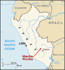
Machu Picchu is located 70 kilometers to the northwest of Cusco, on the crest of the mountain Machu Picchu, located about 2,350 meters above sea level. It is one of the most important archaeological centers in South America and as a consequence the most visited tourist attraction in Peru.
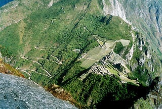
From the top, at the cliff of Machu Picchu, one can appreciate the vertical precipice of 600 meters ending at the foot of the Urubamba River. The location of the city was a military secret because its deep precipices and mountains were an excellent natural defense.
The Machu Picchu sanctuary
In 1981 an area of 325.92 square kilometres surrounding Machu Picchu was declared a "Historical Sanctuary" of Peru. This area, which is not only limited to the ruins themselves, also includes the regional landscape with its flora and fauna, highlighting the abundance of orchids.
The firmest theories maintain that it was an Incan "llacta": a settlement built up to control the economy of the conquered regions. It was the most beautiful llacta of the Incan empire, and would have been built with the specific purpose of protecting the most select of the Incan aristocracy in the event of an attack. It seems it was used in a particular moment as Zapa Inca's "resting place" and also as an "observatory".
Three sectors
According to the archaeologists, Machu Picchu was divided in three great sectors: the Sacred District, the Popular District, to the south, and the District of the Priests and the Nobility (royalty zone).
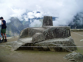
Located in the twentieth zone are the primary archaeological treasures: the Intiwatana, the Temple of the Colors and the Room of the Three Dirt Pebbles. These were dedicated to Inti, their sun god and greatest deity.
In the royalty area, a sector existed for the nobility: a group of houses located in rows over a slope; the residence of the Amautas (wise persons) was characterized by its reddish walls, and the zone of the Ñustas (princesses) had trapezoid-shaped rooms.
Inside the citadel existed a sector assigned as the gas chamber, where the prisoners were punished inside gas niches.
The Monumental Mausoleum is a carved statue with a vaulted interior and carved drawings. It was used for rites or sacrifices.
Architecture
All of the construction in Machu Picchu uses the classic Inca architectural style of polished dry-stone walls of regular shape. The Incas were masters of this technique, called ashlar, in which blocks of stone are cut to fit together tightly without mortar. Many junctions are so perfect that not even a knife fits between the stones.
The Incas never used the wheel in any practical manner. How they moved and placed enormous blocks of stones is a mystery, although the general belief is that they used hundreds of men to push the stones up inclined planes. The Incas did not leave any documentation about that process because they did not employ writing.
The space is composed of 140 constructions including temples, sanctuaries, parks and residences.
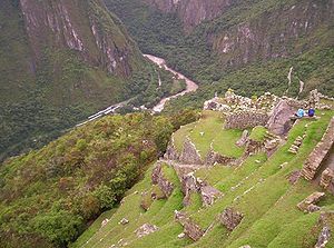
There are more than one hundred flights of stone steps – often completely carved in a single block of granite – and a great number of water fountains, interconnected by channels and water-drainages perforated in the rock, designed for the original irrigation system. Evidence has been found to suggest that the irrigation system was used to carry water from a holy spring, to each of the houses in turn, the order being dictated by the percieved holiness of the inhabitants. It is suspected that this holy spring was at least a factor in the inca's decision to build the city in such a remote location and could hint at the city's true purpose.[citation needed]
Inca road system
Among the thousands of roads constructed by the pre-Columbian cultures in South America, the roads of the Inca were some of the most interesting. This network of roads converged at Cusco, the capital of the Inca Empire. One of them went to the city of Machu Picchu. The Incas distinguished between coastal roads and mountain roads, the former was called Camino de los llanos (road of the levels) and the latter was called Cápac Ñam.
Today, thousands of tourists walk the Inca roads – particularly The Inca Trail – each year, acclimatising at Cusco before starting on a two to four day journey on foot from the Urubamba valley up through the Andes mountain range.
Simone Waisbard, a long-time researcher of Cusco, claims Enrique Palma, Gabino Sánchez and Agustín Lizárraga left their names engraved on one of the rocks there on July 14 1901, having re-discovered it before Bingham. If this is true, however, no word of their finding ever made it to the outside world; Bingham's work brought Machu Picchu to the world's attention.
Visiting Machu Picchu
All visits to Machu Picchu at some point leave from Cusco, which can be reached via a domestic flight from Lima, or international flight from La Paz, in Bolivia. Taking the tourist train from Cusco (which takes 3.5 hours to get to Machu Picchu), you have several options.
The most common way is to take the train to Machu Picchu in the morning, explore the ruins for a few hours and return to Cusco in the afternoon. The train terminates at Puente Ruinas station, where buses take tourists up the mountain to Machu Picchu. Strangely, Machu Picchu station is at Aguas Calientes (2km before Puente Ruinas station) but is not the station used by tourists on a day trip.
Another option is to hike the Inca Trail, on either a four-day or two-day version, both of which are controlled by the government. They require travelers to be reasonably fit. The trip takes a few days, and involves sleeping in tents.
Another option is to stay overnight near the ruins themselves, rather than return on the same day. There are many hotels at nearby Aguas Calientes, or the more expensive Machu Picchu Sanctuary Lodge, the only hotel located at Machu Picchu itself. Buses run from Aguas Calientes to the ruins throughout the day, an 8km ride up the mountain.
A helicopter service from Cusco to Aguas Calientes, via a 24 passenger Russian Mi-8 helicopter, is also available. Helicopter flights direct into Machu Picchu stopped in the 1970s due to concern about their damage to the ruins.
ReferencesISBN links support NWE through referral fees
- ↑ Andrew Mangino (2006-04-12). Elections could avert Peru's lawsuit. Yale Daily News Publishing Company, Inc.. Retrieved June 26, 2006.
- ↑ Hannah Hennessy (2003-12-27). Row erupts over Peru's tourist treasure. BBC Online. Retrieved June 26, 2006.
- ↑ Malcolm Brabant (1999-08-23). World: Americas Inca site cable car plan sparks anger. BBC Online. Retrieved June 26, 2006.
- This article draws heavily on the corresponding article in the Spanish-language Wikipedia, which was accessed in the version of 8 August 2005. It was translated by the Spanish Translation of the Week collaboration.
Image sources
- This article includes images from PromPerú
External links
- Map of Machu Picchu
- Machu Picchu on Google Maps
- Inca Land; Explorations in the Highlands of Peru by Hiram Bingham, available for free via Project Gutenberg
- Inca Show Pits Yale Against Peru (The NY Times, February 2006. Registration required)
- "Rediscovering Machu Picchu" by Bruce Fellman, Yale Alumni Magazine (December 2002)
- Machu Picchu on the Web (directory)
- Quechua Language and Linguistics an extensive site on the language spoken by the people who built of Machu Picchu.
Guides, descriptions, photos
- Machu Picchu on National Geographic
- Machu Picchu from Geometry Step by Step from the Land of the Incas
- Machu Picchu Guide in spanish
- Machu Picchu and Cusco Guide
- A pictorial guide to Machu Picchu
- 360° panoramic video of Machu Picchu - requires Quicktime
- QuickTime Virtual Tour of Machu Picchu and Peru from destination360.com
Credits
New World Encyclopedia writers and editors rewrote and completed the Wikipedia article in accordance with New World Encyclopedia standards. This article abides by terms of the Creative Commons CC-by-sa 3.0 License (CC-by-sa), which may be used and disseminated with proper attribution. Credit is due under the terms of this license that can reference both the New World Encyclopedia contributors and the selfless volunteer contributors of the Wikimedia Foundation. To cite this article click here for a list of acceptable citing formats.The history of earlier contributions by wikipedians is accessible to researchers here:
The history of this article since it was imported to New World Encyclopedia:
Note: Some restrictions may apply to use of individual images which are separately licensed.


