Difference between revisions of "Kumgangsan" - New World Encyclopedia
Anne Inoue (talk | contribs) (temples) |
Anne Inoue (talk | contribs) (added images) |
||
| Line 133: | Line 133: | ||
Image:Geumgangsanpagoda.jpg|<!--金剛山の神渓寺に残る新羅時代後期の塔と金剛山。神渓寺は朝鮮戦争時にこの塔を残して焼失するが、韓国と北朝鮮が共同で再建工事が行われた。2006年2月20日、金剛山にて投稿者写す—>Late Silla period pagoda on the grounds of Kumgansan's Shingyesa Temple. The rest of the temple was destoryed by fire during the Korea War. | Image:Geumgangsanpagoda.jpg|<!--金剛山の神渓寺に残る新羅時代後期の塔と金剛山。神渓寺は朝鮮戦争時にこの塔を残して焼失するが、韓国と北朝鮮が共同で再建工事が行われた。2006年2月20日、金剛山にて投稿者写す—>Late Silla period pagoda on the grounds of Kumgansan's Shingyesa Temple. The rest of the temple was destoryed by fire during the Korea War. | ||
Image:KimIlSungsvisit.JPG|<!--金剛山の岩に刻まれた金日成の漢詩。金正日の満50歳を記念して作った詩で、実の息子を褒めちぎった内容。なお右側には朝鮮文字(ハングル)で同じ内容の詩が刻まれている。2006年8月27日、金剛山にて投稿者写す—>Poem by Kim Il Sung praising his son Kim Jong Il, on Kim Jong Il’s 50th birthday. Written in Hanja, and again in Hangul on the right. | Image:KimIlSungsvisit.JPG|<!--金剛山の岩に刻まれた金日成の漢詩。金正日の満50歳を記念して作った詩で、実の息子を褒めちぎった内容。なお右側には朝鮮文字(ハングル)で同じ内容の詩が刻まれている。2006年8月27日、金剛山にて投稿者写す—>Poem by Kim Il Sung praising his son Kim Jong Il, on Kim Jong Il’s 50th birthday. Written in Hanja, and again in Hangul on the right. | ||
| + | Image:Changansa.gif | ||
| + | Image:Cheongseokjeong.gif | ||
| + | Image:Devilsface.gif | ||
| + | Image:Jipseonbong.gif | ||
| + | Image:Manmulsang.gif | ||
| + | Image:Podukam.gif | ||
| + | Image:Pyohunsa.gif | ||
| + | Image:Singyesa.gif | ||
</gallery> | </gallery> | ||
Revision as of 20:08, 6 December 2007
| KŭGeumgangsan ("Diamond Mountain") | |
|---|---|
| Korean Name | |
| McCune-Reischauer | Kŭmgangsan |
| Revised Romanization | Geumgangsan |
| Hangul | 금강산 |
| Hanja | 金剛山 |
| Statistics | |
| Height | 1,638 meters |
| Location | Kŭmgangsan Tourist Region, North Korea |

| |
Kŭmgangsan or The Diamond Mountains are named for their hard sparkling cliffs, which look like Kŭmgangsǒk (금강석), the Korean word for 'diamond'. Kŭmgangsan is the second highest mountain in North Korea, with its highest peak, Pirobong, reaching 1,638 m. Kŭmgangsan, part of the Taebaek mountain range which runs along the east of the Korean peninsula, is located at 38.58 N latitude, 128.17 E longitude, in the recently created Kŭmgangsan Tourist Region, formerly part of Kangwŏn Province. Kŭmgangsan was the first place in North Korea opened up to allow visits by South Korean tour groups, beginning in 1998.
Natural Beauty
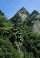
Kŭmgangsan has been known for its beauty since antiquity. It is covered in forests, and the area around Kŭmgangsan has some of the highest levels of precipitation in Korea. The mountain not only features a landscape formed by erosion, but also a great number of deep ponds and waterfalls.
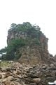
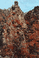
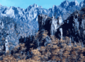
The mountain consists almost entirely of Granite and diorite, which have been weathered over centuries to create a wide variety of shapes. It is estimated that there are over 12,000 picturesque stone formations, ravines, cliffs, stone pillars and peaks.
Kŭmgangsan is commonly divided into three areas: Outer Kŭmgang, Inner Kŭmgang, and Sea Kŭmgang, each with different geological and topographical features. Oekŭmgang, or Outer Kŭmgang with its rough terrain and plummeting waterfalls is considered Kŭmgangsan's masculine manifestation, and is noted for the large number of peaks, such as Jipson Peak (rock of ten thousand formations). Naekŭmgang, or Inner Kŭmgang manifests a softer side of the mountains with hundreds of streams and pools, valleys and breathtaking views. Inner Kŭmgang's Manpok ravine is popular with tourists. Haekŭmgang or Sea Kŭmgang is known for its lagoons and stone pillars. The mountain is called by different names as the seasons turn. Kŭmgangsan, Diamond Mountain, in the spring; Bongraesan, verdant mountain in the summer; Pungaksan, autumn foliage mountain in the autumn and Gaegolsan, skeleton mountain in the winter.
There are many old temples around Kŭmgangsan, although not all are preserved in good condition. Probably the best known temples are Jangan-sa and Maha-yon. Other features of the area include: Sea Manmulsang, Kŭmgang Gate, Samil Lagoon, Piro Peak, Myongyong rock, the Baektap ravine, Manmulsang, Kuryong pond, the Upper Pal pools, Sujong Peak, Ongnyu ravine, the Hanha Stream, and the Sibi waterfalls.
Kŭmgangsan Tourist Region
Since the Korean war in the early 1950's, there has been no surface traffic permitted between North and South Korea, and the few South Korean tourists who were permitted to visit the North had to fly there via a third country, usually China or Japan. Since 1998, South Korean tourists have been allowed to visit Kŭmgangsan, initially traveling by cruise ship, but recently more commonly by. In 2002, the area around the mountain was separated from Kangwŏn Province and organized as a separately administered Tourist Region. The land route connecting the region to South Korea was re-opened in 2003. A rail link exists on the North Korean side up to the border, but no tracks are laid between Gangneung and the border in South Korea.
The Kŭmgangsan Tourist Region is thought to be one way for the North Korean government to receive hard currency from abroad. Therefore the official currency of the tour is neither the South Korean won nor the North Korean won, but the US Dollar. Since 2003 the food and lodging services for the South Korean tourists have been provided by North Koreans staff. The area is being developed by Hyundai Asan, who operate the tours and aho have plans to expand the site with a proper ski resort to complement the current sleigh course, and complete golf courses. Many plans for expansion, however, are in their earliest stages. Since 1998 an average of approximately 200,000 tourists a year have visited the Kŭmgangsan area. In June 2005 Hyundai Asan announced the 1 millionth South Korean visitor to the area.
Natural wonders of Kǔmgangsan
The Diamond Mountains are one of the most spectacular tourist sights in Korea, including ragged cliffs, waterfalls, lagoons and mineral springs, rock formations, peaks and valleys. The mountain
Outer Kǔmgangsan
- Okryudong Valley the most picturesque vally in Outer Kǔmgang, containing Okryudam, Kǔmgangsan's largest mountain lake.
- Kuryong Falls (Nine Dragons Waterfall), with a drop of 74 meters, are an impressive site, one of Korea's three most famous waterfalls. Legend says that nine dragons once inhabited Kuryong Lake, the pool at the foot of the falls. Hiking further up from Kuryong Lake, you can reach Kuryong Rock, with a spectacular view of deep valleys and high elevation lakes.
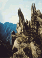
- Manmulsang (Ten Thousand Things) is an area of fantastically shaped cliffs and rocks. At the entrance to Manmulsang is a group of three enormous standing rocks named the Three Fairies (Samsǒn). Other rock formations of every size and shape include Ansimdae (Peace of Mind Lookout), at the opening of the Manmulsang area, Mangjangcheon Spring, with its intoxicatingly tasty water and Haneulmun Gate (Heaven's Gate), a round hole in the stones, that looks like a gate to heaven.
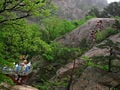
- Sangpaldam (Upper Eight Pools) - across the Yeondamgyo bridge above the Kuryong Falls and up 370 steep steel stairs is the Kuryongdae Cliff observation point, 880 meters above sea level, givin a spectacular vies of the Upper Eight Pools.
- Sejongbong Peak appears to the left as you move from Okryudong Valley to Kuryong Falls, and gives a clear good view of Outer Kǔmgang and Birobong Peak.
- Sujǒngbong Peak High above to the northwest of Onjǒngri, Sujǒngbong sparkles with granite and rock crystals after each rain. There is a large plateau at the peak where one thousand people can rest after their climb and enjoy the view.
- Cheonseondae Cliff offers a stunning view of Outer Kǔmgang
- Mangyangdae Cliff shows several of Kǔmgang's peaks, including Birobong Peak and also offers a bird's eye view of Sea Kǔmgang.
- Dongsǒkdong Valley, between Jipsǒnbong Peak and Sejonbong Peak can be found the Yǒnchundae area where spring first arrives in Kǔmgangsan every year. Dongsǒkdong Valley also offers a view of the East sea.
Inner Kǔmgangsan
- Naegangdong Valley (Inner East River Valley), about 43 kilometers from Outer Kǔmgang's Onjǒngri, marks the beginning of Inner Kǔmgang, with its rich natural resources.
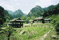
Naegeumgang is the site of Jangansa Temple, one of the four great temples in Mt. Geumgangsan. The temple was established in the 6th century but destroyed during the Korean War. Sambulam, a relief of a standing Buddhist triad, displays a agnificent stone sculpture which was typical in the Goryeo period. Another famous temple in Naegeumgang is Pyohunsa , the last surviving among the four great temples. The temple is located at the entrance to Manpokdong Valley, which is known as presenting the best sceneries in Naegeumgang. The valley s beauty is comparable to Okryudong Valley in Oegeumgang. Bodeokam , the last remaining hermitage in Mt. Geumgangsan, looks amazing with the hermitage hanging on a 150-meter-high cliff in Beopgibong Peak by being propped up by a single copper pole. Last but not least is Birobong Peak, the highest and most famous peak in Mt. Geumgangsan. The Naegeumgang District officially opened in June of 2007, and now its beauty can be enjoyed by all visitors.
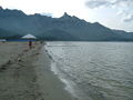
Sea Kǔmgangsan
- Samilpo Lagoon. According to legend, a king once came to the lagoon for a one-day visit but was so amazed by its beauty that he stayed there for three days, hence the name Samil (three days). You can rent a boat at Samilpo.
As the name Haegeumgang or Sea Diamonds indicates, the area is beautiful as if Mt. Geumgangsan were taken out into the sea. The seascape stretching about 40 kilometers includes Haemanmulsang, the Stone Images of Ten Thousand Things in the Sea, Ipseok Rock, and Chilseongseok Rock. The Haegeumgang course is divided into three districts which are Samilpo Lake, Haegeumgang Seashore, and Chongseokjeong Pavilion. Samilpo Lake District Samilpo is a lake with the circumference of about 8 kilometers, and the depth of 9 to 13 meters. The north of the lake is surrounded by 36 low peaks of Mt. Geumgangsan. To the right at the district’s entrance is a trail leading to Janggundae and Chungseonggak pavilion which offers a full view of Samilpo Lake. Below is a 56-meter long suspension bridge, the longest one in Mt. Geumgangsan. The district’s major tourist attractions include Waudo Islet in the shape of a big cow lying on the ground, Bongraedae where tourists can enjoy an unobstructed view of the lake at the highest point, and Yeonhwadae Pavilion where the highest Birobong Peak can be seen. Haegeumgang’s Seashore District Located 4 kilometers east of Samilpo Lake, Haegeumgang Seashore features an amazing scenery with breathtaking rock formations stretching out to the sea. Taking a cue from Manmulsang in the outer mountains, the oddlyshaped rocks are called Haemanmulsang, which means the Stones Images of Ten Thousand Things in the Sea. A must-see in this district is Songdo, a rocky islet rising about 50 meters above sea level. Chongseokjeong Pavilion District A 36-kilometer drive north along a seaside road from Goseonghang Port brings tourists to Chongseokjeong in Gojeo-eup, Tongcheongun. As the name, Chong-seokjeong, means clusters of rocks, this district features a kilometer-long stretch of cliffs along the coastline with thousands of high rock columns in various shapes rising above the sea. Chongseokjeong Pavilion used to mark this spot, though it is long gone. This district is not yet open to tourists.
Buddhist temples and Hermitages
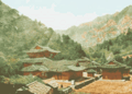
Although clear statistics are not available, it is likely that since Kǔmgangsan is located in Communist North Korea, the majority of the Buddhist temples are no longer active, and have not been kept in repair to the same extent as mountain temples on the mountains in South Korea. There are four major temples recorded as being located on Kǔmgangsan, and up to one hundred or more smaller temples during the Buddhism's peak in the Silla and Goryeo periods. Even during the Joseon Dynasty, when Confucianism was favored over Buddhism, the Buddhist temples on Kǔmgangsan remained active. However, after the effects of the Japanese occupation, the Korean war and the Communist regime in North Korea, reports show that only one temple on Kǔmgangsan remains active today.
There were Probably the best known temples on Kǔmgangsan are Jangan-sa and Maha-yon.
- Pyohunsa Temple, in the Inner Kǔmgang area, was built in 670 C.E., located about two hours by bus from the Onjunggak tourist complex and the Outer Kǔmgang Hotels, is said to be the only active temple remaining on Kǔmgangsan. Once one of the most important Seon (Zen) monasteries in Korea, the temple now is inhabited by two monks. Many of the temple's cultural assets were lost during the period of Japanese rule.
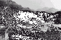
- Changansa Temple, built during the Unified Silla period, was used during the Korean war as the headquarters for North Korea's Fifth Army and to house several hundred South Korean and about one hundred American prisoners of war. By the end of the war, the temple was entirely destroyed.
- Yujomsa Temple was destroyed during the Korean war and not rebuilt.
- Singyesa Temple, built during the Silla Kingdom in 519, one of the temples on Kǔmgangsan that was destroyed during the Korean war, is being reconstructed by a joint North-South initiative organized by the Jogye Order of Buddhism in South Korea and the Joseon Buddhist Federation, along with government bodies from both Koreas. Reconstruction work began in 2004. When finished, it is expected that the temple will be a cultural tourist site, rather than an active worshiping temple.
- Podukam, a small Buddhist temple only 3.3 meters by 5.3 meters in size, built in 627 during hte Goguryeo Dynasty, is located in Inner Kǔmgang at the top of a 20-meter-high cliff. Although the temple is still intact, it is structurally unsafe, so nobody goes inside it any more.
- Mahayonsa, another temple formerly on Kǔmgangsan, but destroyed during the Korean war
Pyohunsa Temple, a Buddhist temple sitting at the bottom of Naekumgang. It takes nearly two hours by bus to arrive at Pyohunsa from Onjunggak, a sprawling tourist complex located next to the Oekumgang Hotel.
The view from the temple and the setting behind it is exquisite. Among the four famous temples in Mount Kumgang, Pyohunsa is the only one that remains standing as it was when originally built.
The rest ― Changan, Yujom and Singye temples ― were, according to North Korean guides, destroyed as a result of bombing by the U.S. air force during the Korean War. Visitors can see the site where Changan temple once stood, as it not far from Pyohunsa, which was built in 670 C.E., during the Silla Dynasty. Pyohunsa has two Buddhist monks.
Kumgang Jeondo

|
| Geumgang jeondo (General View of Mt. Geumgansan or The Diamond Mountains) |
| Jeong Seon, 1734 |
| Ink and light colors on paper |
| 130.7 × 94.1 cm |
| Hoam Art Museum |
Kǔmgang Jeondo (General view of Mt. Kǔmgang) is a famous landscape painting by Jeong Seon during the reign of King Yeongjo. It was classified as the 217th National Treasure of Korea on August 6th, 1984. The painting is currently in the collection of the Hoam Art Museum in Yongin, Gyeonggi Province on loan by the owner, Yi Geohui.
While many of his contemporaries painters imitated the latest art trends imported from China, Jeong Seon ignored them, creating unique themes based on Korean landscapes. His catalogue of paintings of Kǔmgansan made him famous and the preeminent painter of his time at the age of 37. He eventually painted around 100 images of the mountains which still exist to this day. The artist’s love of the mountains influenced other artists to depict the Kǔmgansan and even encouraged mapmakers to make maps of the area.
Although Jeong Seon made many paintings of Kǔmgangsan, this painting is the largest and considered his best. Like many of his paintings, Jeong Seon painted this landscape while actually viewing the mountains. The painting is 130.7 centimeters in height and 94.1 centimeters in width. It is painted with India ink. The painting is of Naekǔmgang, Inner Kǔmgang. The painting depicts Kǔmgangsan's twelve thousand peaks. The highest peak, Birobong, lies in the background and water flows from it toward a valley called Manpokdong which is divided from the left and right. The high sharp peaks are depicted by the artist with lines painted up and down while he used a dotting brush method to depict the earthen peaks, making them appear relatively soft and lush. This composition harmonizes the contrasting sharp edges of the rocky peaks with the softer earthen peaks.
Jeong Seon included the title of the painting, some comments, and his pen name, Gyeomjae, in the upper right hand corner. The inscription also dates the painting to 1734 when he was 59 years old. The artist’s comments reads:
Even if you visit the mountain yourself and tread on its every nook and cranny, how can your joy be compared with what you feel upon viewing this picture from your bedside?
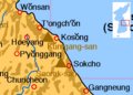
Location of Kumgangsan
- Gumgang2.jpg
High elevation cliffs on Kumgangsan
Kumgangsan rock formations
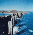
A view of Kŭmgangsan from the coast at Sea Kŭmgang
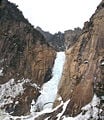
Kuryong (Nine Dragons) Waterfall
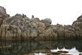
A view of Sea Kumgang from the sea.
The path to Nine Dragons Waterfall
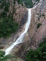
Nine Dragons Waterfall from japanese article
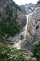
Nine Dragons Waterfall on Kŭmgangsan
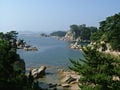
A view of Sea Kumgang.
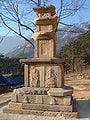
Late Silla period pagoda on the grounds of Kumgansan's Shingyesa Temple. The rest of the temple was destoryed by fire during the Korea War.
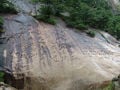
Poem by Kim Il Sung praising his son Kim Jong Il, on Kim Jong Il’s 50th birthday. Written in Hanja, and again in Hangul on the right.


See also
- List of Korea-related topics
- List of mountains in Korea
- Geography of North Korea
Notes
External links
- Korean Buddhism - Inner Kumgang. Retrieved December 6, 2007.
- Mt. Kumgang Tour. Retrieved November 9, 2007. Tel+82-2-739-1090, organizes tours from South Korea to Kumgangsan.
- Hyundae Asan's North Korea tour department. Tel. +82-2-3669-3000, the company behind the tours; some information in English. Retrieved November 9, 2007.
- GOnSEE, official travel agency handling international visitors to Kǔmgangsan. Retrieved November 9, 2007.
- POW report.
- Travel guide to Kumgangsan from Wikitravel
Credits
New World Encyclopedia writers and editors rewrote and completed the Wikipedia article in accordance with New World Encyclopedia standards. This article abides by terms of the Creative Commons CC-by-sa 3.0 License (CC-by-sa), which may be used and disseminated with proper attribution. Credit is due under the terms of this license that can reference both the New World Encyclopedia contributors and the selfless volunteer contributors of the Wikimedia Foundation. To cite this article click here for a list of acceptable citing formats.The history of earlier contributions by wikipedians is accessible to researchers here:
The history of this article since it was imported to New World Encyclopedia:
Note: Some restrictions may apply to use of individual images which are separately licensed.