Difference between revisions of "Honolulu, Hawaii" - New World Encyclopedia
Mike Butler (talk | contribs) |
Mike Butler (talk | contribs) |
||
| Line 136: | Line 136: | ||
In the [[Hawaiian language]],''Honolulu'' means "sheltered bay" or "place of shelter." | In the [[Hawaiian language]],''Honolulu'' means "sheltered bay" or "place of shelter." | ||
| − | Honolulu | + | Honolulu extends about 10 miles (16km) along the southeast coast of the island of Oahu, and goes four miles (six kilometers) inland across a plain into the foothills of the Koolau Range. The closest location on the mainland of the [[United States]] to Honolulu is the [[Point Arena]], [[California]] [[Lighthouse]], at 2353 miles or (3787 kilometers). |
Within Honolulu proper can be found several [[volcanic cone]]s: [[Punchbowl Crater|Punchbowl]], [[Diamond Head, Hawaii|Diamond Head]], [[Koko Head]] (includes [[Hanauma Bay]]), Koko Crater, Salt Lake, and Aliamanu being the most conspicuous. | Within Honolulu proper can be found several [[volcanic cone]]s: [[Punchbowl Crater|Punchbowl]], [[Diamond Head, Hawaii|Diamond Head]], [[Koko Head]] (includes [[Hanauma Bay]]), Koko Crater, Salt Lake, and Aliamanu being the most conspicuous. | ||
Revision as of 21:22, 1 December 2008
| Honolulu, Hawaii | |||
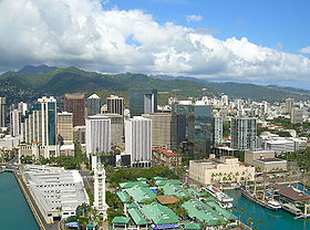
| Aerial view of downtown from Honolulu Harbor | |||
|
|||
| Nickname: Crossroads of the Pacific, Sheltered Bay | |||
| Motto: Ha’aheo No ‘O Honolulu (Honolulu Pride)[1] | |||
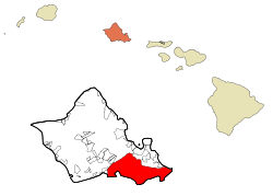
| Location in Honolulu County and the state of Hawaii | |||
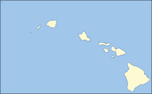
| Location in Hawaii | |||
| Coordinates: {{#invoke:Coordinates|coord}}{{#coordinates:21|18|32|N|157|49|34|W|type:city | |||
|---|---|---|---|
| name= }} | |||
| Country | United States | ||
| State | Hawaii | ||
| County | Honolulu | ||
| Government | |||
| - Mayor | Mufi Hannemann | ||
| Area | |||
| - CDP | 105 sq mi (272.1 km²) | ||
| - Land | 85.7 sq mi (222.0 km²) | ||
| - Water | 19.3 sq mi (50.1 km²) | ||
| Elevation | 0 ft (Sea Level 0 m) | ||
| Population (2000) | |||
| - CDP | 371,657 | ||
| - Metro | 909,863 | ||
| Time zone | Hawaii-Aleutian Standard Time (UTC-10) | ||
| Zip Code | 96801-96825 | ||
| Area code(s) | 808 | ||
| FIPS code | 15-17000 | ||
| GNIS feature ID | 0366212 | ||
| Website: http://www.honolulu.gov/ | |||
Honolulu is the capital and most populous census-designated place (CDP) in the U.S. state of Hawaii. Although Honolulu refers to the urban area on the southeastern shore of the island, the city and the county are consolidated, known as the City and County of Honolulu, and the city and county is designated as the entire island of Oahu.
Geography
In the Hawaiian language,Honolulu means "sheltered bay" or "place of shelter."
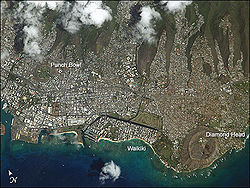
Honolulu extends about 10 miles (16km) along the southeast coast of the island of Oahu, and goes four miles (six kilometers) inland across a plain into the foothills of the Koolau Range. The closest location on the mainland of the United States to Honolulu is the Point Arena, California Lighthouse, at 2353 miles or (3787 kilometers).
Within Honolulu proper can be found several volcanic cones: Punchbowl, Diamond Head, Koko Head (includes Hanauma Bay), Koko Crater, Salt Lake, and Aliamanu being the most conspicuous.
While the city is clearly in the tropics, the climate (temperature and humidity) is moderated by its mid-ocean location, and has a warm semi-arid climate. The average maximum daytime temperature in January of 80°F (27°C), rising to an average maximum of around 88°F (31°C) in July. Temperatures exceed 90°F (32°C) only rarely, with lows in the 50's°F (15°C) occurring perhaps once or twice in a year. Mean annual precipitation is 22 inches (558mm).
Rivers and canals Size – land area, size comparison Environmental issues Districts
The Honolulu District is located on the southeast coast of Oahu between Makapuu and Halawa. The District boundary follows the Koolau crestline, so Makapuu Beach is in the Koolaupoko District. On the west, the district boundary follows Halawa Stream, then crosses Red Hill and runs just west of Aliamanu Crater, so that Aloha Stadium, Pearl Harbor (with the USS Arizona Memorial), and Hickam Air Force Base are actually all located in the island's Ewa District.
Most of the city's commercial and industrial developments are located on a narrow but relatively flat coastal plain, while numerous ridges and valleys located inland of the coastal plain divide Honolulu's residential areas into distinct neighborhoods: some spread along valley floors (like Manoa in Manoa Valley) and others climb the interfluvial ridges.
- Downtown Honolulu is the financial, commercial, and governmental center of Hawaii. On the waterfront is Aloha Tower, which for many years was the tallest building in Hawaii. Currently the tallest building is the 438-foot (134 m)-tall First Hawaiian Center, located on King and Bishop Streets. Hawaii Pacific University-downtown campus is also located there.
- The Arts District Honolulu in downtown/Chinatown is on the eastern edge of Chinatown. It is a 12-block area bounded by Bethel & Smith Streets and Nimitz Highway and Beretania Street - home to numerous arts and cultural institutions. It is located within the Chinatown Historic District.[1]
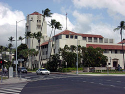
- The Capitol District is the eastern part of Downtown Honolulu. It is the current and historic center of Hawaii's state government, incorporating the Hawaii State Capitol, Iolani Palace, Honolulu Hale (City Hall), State Library, and the statue of King Kamehameha I, along with numerous government buildings.
- Kakaʻako is a light-industrial district between Downtown and Waikīkī that has seen a large-scale redevelopment effort in the past decade. It is home to two major shopping areas, Ward Warehouse and Ward Centre. The John A. Burns School of Medicine, part of the University of Hawaiʻi at Manoa is also located there. A Memorial to the Ehime Maru Incident victims is built at Kakaako Waterfront Park.
- Waikīkī is the world famous tourist district of Honolulu, located between the Ala Wai Canal and the Pacific Ocean next to Diamond Head. Numerous hotels, shops, and nightlife opportunities are located along Kalakaua and Kuhio Avenues. World-famous Waikīkī Beach attracts millions of visitors a year. Just west of Waikīkī is Ala Moana Center, the world's largest open-air shopping center. A majority of the hotel rooms on Oahu are located in Waikīkī.
- Manoa and Makiki are residential neighborhoods located in adjacent valleys just inland of downtown and Waikīkī. Manoa Valley is home to the main campus of the University of Hawaiʻi.
- Nuʻuanu and Pauoa are upper-middle-class residential districts located inland of downtown Honolulu. The National Memorial Cemetery of the Pacific is located in Punchbowl Crater fronting Pauoa Valley.
- Palolo and Kaimuki are neighborhoods east of Manoa and Makiki, inland from Diamond Head. Palolo Valley parallels Manoa and is a residential neighborhood. Kaimuki is primarily a residential neighborhood with a commercial strip centered on Waialae Avenue running behind Diamond Head. Chaminade University is located in Kaimuki.
- Waialae and Kahala are the upper-class districts of Honolulu located directly east of Diamond Head, where there are many high-priced homes. Also found in these neighborhoods are the Waialae Country Club and The Kahala Hotel & Resort.
- East Honolulu includes the residential communities of ʻĀina Haina, Niu Valley, and Hawaiʻi Kai. These are considered upper-middle-class neighborhoods. The upscale gated communities of Waiʻalae ʻiki and Hawaiʻi Loa Ridge are also located here.
- Kalihi and Palama are working-class neighborhoods with a number of government housing developments. Lower Kalihi, toward the ocean, is a light-industrial district.
- Salt Lake and Aliamanu are (mostly) residential areas built in extinct tuff cones along the western end of the Honolulu District, not far from the Honolulu International Airport.
- Moanalua is two neighborhoods and a valley at the western end of Honolulu, and home to Tripler Army Medical Center.
History
It is not known when Honolulu was first settled by the original Polynesian migrants to the archipelago. Oral histories and artifacts indicate that there was a settlement where Honolulu now stands in the 12th century. However, after Kamehameha I conquered Oʻahu in the Battle of Nuʻuanu at Nuʻuanu Pali, he moved his royal court from the Island of Hawaiʻi to Waikīkī in 1804. His court later relocated, in 1809, to what is now downtown Honolulu.
Captain William Brown of England was the first foreigner to sail, in 1794, into what is now Honolulu Harbor. More foreign ships would follow, making the port of Honolulu a focal point for merchant ships traveling between North America and Asia.
In 1845, Kamehameha III moved the permanent capital of the Hawaiian Kingdom from Lahaina on Maui to Honolulu. He and the kings that followed him transformed Honolulu into a modern capital, erecting buildings such as St. Andrew's Cathedral, ʻIolani Palace, and Aliʻiōlani Hale. At the same time, Honolulu became the center of commerce in the Islands, with descendants of American missionaries establishing major businesses in downtown Honolulu.
Despite the turbulent history of the late 19th century and early 20th century, which saw the overthrow of the Hawaiian monarchy, Hawaiʻi's subsequent annexation by the United States, and the Japanese attack on Pearl Harbor, Honolulu would remain the capital, largest city, and main airport and seaport of the Hawaiian Islands.
An economic and tourism boom following statehood brought rapid economic growth to Honolulu and Hawaiʻi. Modern air travel would bring thousands, eventually millions (per annum) of visitors to the Islands. Today, Honolulu is a modern city with numerous high-rise buildings, and Waikīkī is the center of the tourism industry in Hawaiʻi, with thousands of hotel rooms.
Government
The state government of Hawaii is modeled after the U.S. federal government with adaptations originating from the kingdom era of Hawaiian history. The Governor of Hawaii and assisted by the lieutenant governor, both elected. The Hawaii State Senate comprises 25 members, and the Hawaii State House of Representatives comprises 51 members.
The City and County of Honolulu is the only incorporated city in Hawaii, as all other local government entities are administered at the county level.
Honolulu is administered under a consolidated city-county form of government employing a strong mayor-council system. The Mayor of Honolulu holds executive privilegesTemplate:Mdashas opposed to mayors with only ceremonial powersTemplate:Mdashand the Honolulu City Council serves as the legislature. Mufi Hannemann currently serves as Mayor of Honolulu. His term ends January 2, 2010.
The city and county works with an annual operating budget of over USD 1.6 billion (2008 fiscal year.)[2] The Honolulu Fire Department and Honolulu Police Department are administered by the mayor and city council through appointed officials.
Economy
eastbound into Honolulu CDP]]
Overview – Any specialization: For instance, is a manufactured product is associated with particular cities a. Milwaukee—cheese and beer b. Los Angeles—entertainment industry c. Sheffield—coal d. top 20 cities in the U.S. are highly specialized
Per capita GDP, rank Financial and business services sector Tourism Manufacturing Transport: Road, rail, air, sea The city is a hub for Germany’s and Europe’s high-speed passenger rail network. Autobahns radiate from Cologne's ring road. Cologne's international airport is Cologne Bonn Airport, also called Konrad Adenauer Airport. The Rhine harbor is one of the larger inland ports in Germany. Public transport within the city includes buses, a subway system, and the Rheinseilbahn aerial tramway crossing the Rhine. Cologne has pavement-edge cycle lanes linked by cycle priority crossings.
The median income for a household in the CDP was $45,112, and the median income for a family was $56,311. Males had a median income of $36,631 versus $29,930 for females. The per capita income for the CDP was $24,191. About 7.9% of families and 11.8% of the population were below the poverty line, including 14.6% of those under the age of 18 and 8.5% of those 65 and older.
Air
Located on the western end of Honolulu proper, Honolulu International Airport (HNL) is the principal aviation gateway to the state of Hawaii.
Highways
Several freeways serve Honolulu:
- Interstate H-1, which, coming into the city from the west, passes Hickam Air Force Base and Honolulu International Airport, runs just north of Downtown and continues eastward through Makiki and Kaimuki, ending at Waialae/Kahala. H-1 connects to Interstate H-2 from Wahiawa and Interstate H-3 from Kaneohe, west of the city proper.
- Interstate H-201—also known as the Moanalua Freeway and formerly numbered Hawaii State Rte. 78—connects two points along H-1: at Aloha Stadium and Fort Shafter. Close to H-1 and Aloha Stadium, H-201 has an exchange with the western terminus of Interstate H-3 to the windward side of Oahu (Kaneohe). This complex of connecting ramps, some directly between H-1 and H-3, is in Halawa.
- Interstate H-2 runs from Pearl City, through Waipio and Mililani, to Wahiawa and dissolves into a highway (Wilikina Drive) near the military base, U.S. Army base Schofield Barracks and Army Airfield Wheeler. The interstate is a convenient way to get to the island's North Shore.
- Interstate H-3 is also known as the John A. Burns Freeway, and runs from the H-1 in Honolulu to the community of Kane'ohe.
Other major highways that link Honolulu proper with other parts of the Island of Oahu are:
- Pali Highway, State Rte. 61, crosses north over the Koolau range via the Pali Tunnels to connect to Kailua and Kaneohe on the windward side of the Island.
- Likelike Highway, State Rte. 63, also crosses the Koolau to Kaneohe via the Wilson Tunnels.
- Kalanianaole Highway, State Rte. 72, runs eastward from Waialae/Kahala to Hawaii Kai and around the east end of the island to Waimanalo Beach.
- Kamehameha Highway, State Rte. 99, runs westward from near Hickam Air Force Base to Aiea and beyond, eventually running through the center of the island and ending in Kaneohe.
Like most major American cities, the Honolulu metropolitan area experiences heavy traffic congestion during rush hours, especially to and from the western suburbs of Kapolei, Ewa, Aiea, Pearl City, Waipahu, and Mililani. Land for expanding road capacity is at a premium everywhere on Oahu.
Public transportation
Bus
Established by former Mayor Frank F. Fasi, Honolulu's TheBus system has been twice honored by the American Public Transportation Association bestowing the title of "America's Best Transit System" for 1994–1995 and 2000–2001. TheBus operates 107 routes serving Honolulu and outlying areas on Oahu with a fleet of 531 buses, and is run by the non-profit corporation Oahu Transit Services in conjunction with the city Department of Transportation Services. Honolulu is ranked 4th for highest per-capita use of mass transit in the United States.[3]
Rail
{{#invoke:Message box|ambox}}
Currently, there is no urban rail transit system in Honolulu, although electric street railways were once used during the early days of Honolulu's history. The first major attempt was called the Honolulu Area Rail Rapid Transit project, popularly known as HART. Originally proposed in 1968 by Mayor Neal S. Blaisdell and supported by his successor, Frank Fasi, HART was originally envisioned as a 29-mile line from Pearl City to Hawaii Kai. By 1980, however, the project's length was cut to an 8-mile segment between the University of Hawaii at Manoa and Honolulu International Airport.
In the wake of proposed budget cuts by President Ronald Reagan, including the elimination of all funding for transit projects by 1985, newly elected Mayor Eileen Anderson cancelled the project in 1981 and returned grants and funding to their sources,[4][5] arguing the project would break her vow of fiscal responsibility.[6].[7]
After defeating Anderson in 1984 to regain the mayorship, Fasi started plans to revive the HART project. Funding avenues that Fasi explored included a substantial (66 percent) increase in the gasoline tax and diversion of money earmarked for then-stalled nterstate H-3 to be used for the project. In 1990, Governor John Waihee proposed allowing counties to collect a 0.5% increase in the excise tax to be used for transportation projects, and the state legislature approved the plan in May 1990. The counties would have until October 1, 1992 to enact the increase.
In October 1991, the Fasi administration chose Oahu Transit Group to develop the rail line, which was based on cars by AEG Westinghouse similar to those used in the Bay Area Rapid Transit system. The U.S. House amended a transit bill to include $618 million for Honolulu's project, about one-third of the cost, and the Council in November entered into a joint funding agreement with the state.
On September 23, 1992, the City Council voted 5-4 against enacting the tax increase, which effectively killed the project. Fasi made unsuccessful attempts to have a rail referendum (which was struck down by the courts), and to have private investors fund part of the line. The House revoked funding for the project on May 11, 1993, citing lack of guaranteed local funding.
In 2005, under the administration of Mufi Hannemann, the city, county and state approved development of an action plan for a unspecific rapid transit system, known as the Honolulu High-Capacity Transit Corridor Project, to be built in several phases. The initial line proposed linking Kapolei in West Oahu to the University of Hawaii at Manoa. Then on December 22, 2006 the city council approved a fixed-guideway system meant to accommodate a rapid transit system of rail or buses, running from Kapolei in West Oahu to Ala Moana, with spurs into Waikiki and Manoa.[8]
Opponents of the proposed rail system attempted to place a measure on the Honolulu ballot which would have prohibited any rail system from being used, but failed to gather the required signatures in time. In response, the Honolulu City Council voted to put a question on the Honolulu ballot which would direct the city transportation department to create a steel-wheel-on-steel-rail transit system.
On November 4th, 2008, the residents of Honolulu voted to allow the process of developing the rail project to continue. The trains will be approximately 200 feet long, electric, steel wheel to steel rail technology and will capable of carrying more than 300 passengers each.[9][10] The measure passed with 52% of the vote.[11]
Demographics
The population of the census designated place was 371,657 at the 2000 census, while the population of the City and County was 909,863. Race/ethnicity - historical background of ethnic groups Language Religion
Colleges and universities in the Honolulu community include University of Hawaii at Manoa, Chaminade University, and Hawaii Pacific University.
Hawaii Department of Education operates public schools in Honolulu.Punahou School , Kalani High School and President Theodore Roosevelt High School serve the Honolulu community.
As of the censusGR2 of 2000, there were 371,657 people, 140,337 households, and 87,429 families residing in the CDP. The population density was 4,336.6 people per square mile (1,674.4/km²). There were 158,663 housing units at an average density of 1,851.3/sq mi (714.8/km²). The racial makeup of the CDP was 19.67% White, 1.62% Black or African American, 0.19% Native American, 55.85% Asian, 6.85% Pacific Islander, 0.89% from other races; and 14.93% from two or more races. Hispanic or Latino of any race were 4.37% of the population.
There were 140,337 households out of which 23.7% had children under the age of 18 living with them, 45.5% were married couples living together, 12.1% had a female householder with no husband present, and 37.7% were non-families. 29.7% of all households were made up of individuals and 10.0% had someone living alone who was 65 years of age or older. The average household size was 2.57 and the average family size is 3.23.
In the CDP the population was spread out with 19.2% under the age of 18, 8.9% from 18 to 24, 29.9% from 25 to 44, 24.1% from 45 to 64, and 17.8% who were 65 years of age or older. The median age was 40 years. For every 100 females there were 96.6 males. For every 100 females age 18 and over, there were 94.5 males.
Cultural institutions
Performing arts
Established in 1900, the Honolulu Symphony is the oldest US symphony orchestra west of the Rocky Mountains. Other classical music ensembles include the Hawaii Opera Theatre. Honolulu is also a center for Hawaiian music. The main music venues include the Neal Blaisdell Center Concert Hall, the Waikiki Shell, and the Hawaii Theatre.
Honolulu also includes several venues for live theater, including the Diamond Head Theatre.
Visual arts
There are various institutions supported by the state and private entities for the advancement of the visual arts. The Honolulu Academy of Arts is endowed with the largest collection of Asian and Western art in Hawaii. It also has the largest collection of Islamic art, housed at the Shangri La estate. The academy hosts a film and video program dedicated to arthouse and world cinema in the museum's Doris Duke Theatre, named for the academy's historic patroness Doris Duke.
The Contemporary Museum is the only contemporary art museum in the state. It has two locations: main campus in Makiki and a multi-level gallery in downtown Honolulu at the First Hawaiian Center.
The Hawaii State Art Museum is also located in downtown Honolulu at No. 1 Capitol District Building and boasts a collection of art pieces created by local artists as well as traditional Hawaiian art. The museum is administered by the Hawaii State Foundation on Culture and the Arts.
Natural museums
Recognized internationally as the premier cultural institution of Hawaii, the Bishop Museum is the largest of Honolulu's museums. It is endowed with the state's largest collection of natural history specimens and the world's largest collection of Hawaiiana and Pacific culture artifacts. The Honolulu Zoo is the main zoological institution in Hawaii while the Waikiki Aquarium is a working marine biology laboratory. The Waikiki Aquarium is partnered with the University of Hawaii and other universities worldwide. Established for appreciation and botany, Honolulu is home to several gardens: Foster Botanical Garden, Liliuokalani Botanical Garden, Walker Estate, among others.
Sports
Currently, Honolulu has no professional sports teams. However, Honolulu hosts the NFL's annual Pro Bowl each February in addition to the NCAA football Hawaii Bowl. Honolulu also supports the Hawaii Winter League annually from late September to late November, hosting minor league players from MLB, NPB, and Korea. Games are hosted at Les Murakami and Hans L'Orange Park. Fans of spectator sports in Honolulu generally support the football, volleyball, basketball, and baseball programs of the University of Hawaii at Manoa. High school sporting events, especially football, are especially popular. Venues for spectator sports in Honolulu include:
- Les Murakami Stadium at UH-Manoa (baseball)
- Stan Sheriff Center at UH-Manoa (basketball and volleyball)
- Neal Blaisdell Center Arena (basketball)
Aloha Stadium, a venue for American football and soccer (football), is located in nearby community of ʻAiea.
Honolulu's mild climate lends itself to year-round fitness activities as well. In 2004, Men's Fitness magazine named Honolulu the fittest city in the U.S. Honolulu is also home to three large road races:
- The Great Aloha Run is held annually on Presidents' Day.
- The Honolulu Marathon, held annually on the second Sunday in December, draws more than 20,000 participants each year, about half to two thirds of them from Japan.
- The Honolulu Triathlon is an Olympic distance triathlon event governed by USA Triathlon. Held annually in May since 2004, there is an absence of a sprint course.
Former professional franchises
- Hawaii Islanders (Pacific Coast League, 1961-1987)
- Hawaiian Islanders (af2, 2002-2004)
- Team Hawaii (North American Soccer League, 1977)
- The Hawaiians (World Football League, 1974-1975)
Media
Tourist attractions
- Ala Moana
- Aloha Tower
- Bishop Museum
- Diamond Head
- Hanauma Bay
- Honolulu Academy of Arts
- ʻIolani Palace
- Lyon Arboretum
- National Memorial Cemetery of the Pacific
- USS Arizona Memorial
- Waikiki Aquarium
- Waikiki Beach
- See also: Oahu
Gallery
- Honolulu port.jpg
View of Honolulu from an aircraft departing from Honolulu International Airport
- Honoluluviewfromhnlairport.JPG
View of Honolulu skyline from Honolulu International Airport
ReferencesISBN links support NWE through referral fees
- ↑ "Events, Official Web Site for The City and County of Honolulu." City and County of Honolulu. Accessed October 14, 2008.
- ↑ City and County of Honolulu Department of Budget and Fiscal Services, FY 2008 Operating Budget (p. 17)
- ↑ National Transit Database, Top Transit Cities (2006)
- ↑ "Honolulu: trains at last?", 'Railway Age', November, 1990. Retrieved 2008-01-19.
- ↑ "Honolulu's mayor ends proposal for rail line in downtown area", 'New York Times', June 28, 1981. Retrieved 2008-01-20.
- ↑ Leavitt, Judith A. (1985). American Women Managers and Administrators. Greenwood Press, pp. 8-9. ISBN 0313237484.
- ↑ "Will rail fly this time?", 'Honolulu Star-Bulletin', December 16, 1998. Retrieved 2008-10-12.
- ↑ Kua, Crystal, "All Aboard!", Honolulu Star-Bulletin, December 23, 2006. Retrieved 2008-11-21. (written in English)
- ↑ http://www.khnl.com/Global/story.asp?S=9295785 Honolulu - Rail transit passes
- ↑ http://www.honoluluadvertiser.com/apps/pbcs.dll/article?AID=/20081106/NEWS01/811060369/1001/NEWS05 Honolulu rail might be rerouted to airport
- ↑ "Voters on Oahu say 'yes' to rail", 'Honolulu Advertiser', November 5, 2008. Retrieved 2008-11-05.
External links
- Travel guide to Honolulu, Hawaii from Wikitravel
- Encyclopaedia Britannica Honolulu Retrieved December 1, 2008.
- City & County of Honolulu official site
- Hawaii Vistors and Convention Bureau
Credits
New World Encyclopedia writers and editors rewrote and completed the Wikipedia article in accordance with New World Encyclopedia standards. This article abides by terms of the Creative Commons CC-by-sa 3.0 License (CC-by-sa), which may be used and disseminated with proper attribution. Credit is due under the terms of this license that can reference both the New World Encyclopedia contributors and the selfless volunteer contributors of the Wikimedia Foundation. To cite this article click here for a list of acceptable citing formats.The history of earlier contributions by wikipedians is accessible to researchers here:
The history of this article since it was imported to New World Encyclopedia:
Note: Some restrictions may apply to use of individual images which are separately licensed.
